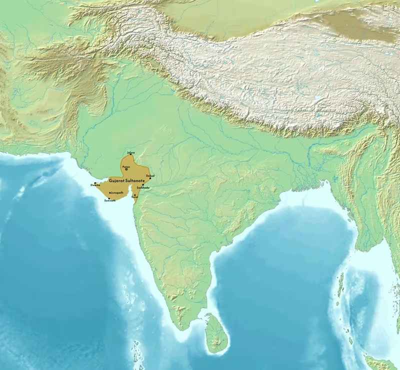
Gujarat Sultanate, 1394–1573
Introduction
The Gujarat Sultanate emerged when Zafar Khan, governor of Gujarat under the weakening Tughlaq dynasty, declared independence in 1394. Its political geography developed around the fertile plains and long western coastline of Gujarat, but its influence repeatedly extended toward Rajput territories, Malwa, Khandesh, the Deccan, and the ports of the Arabian Sea. This map follows that changing landscape from the late fourteenth-century break with Delhi to Akbar's annexation of Gujarat in 1573.
The movement of the capital from Anhilwada Patan to Ahmedabad in 1411 marked a decisive reorientation of the sultanate. Ahmedabad became the principal seat of government and a major centre of architecture, administration, and royal life. Later rulers expanded the kingdom through campaigns against regional chiefs and neighbouring states. Under Mahmud Begada, the sultanate reached a particularly prosperous phase and captured the forts of Girnar and Champaner. Under Bahadur Shah, its territorial extent became greatest, although Mughal and Portuguese pressure soon transformed the political map.
The map should be read as a historical reconstruction of political influence rather than a claim that every listed region was continuously governed in the same way. The Gujarat administration distinguished between crown lands under direct authority and feudatory territories whose rulers retained internal control while paying tribute or providing military service.
Historical Context
From Tughlaq province to independent sultanate
The political weakening of Delhi after Timur's invasion created the circumstances in which Gujarat's governor could establish an independent state. Zafar Khan had been appointed governor in 1391 by Sultan Nasir-ud-Din Muhammad bin Tughluq and received the title Muzaffar Khan. In 1392, he defeated Farhat-ul-Mulk at the battle of Kamboi near Anhilwada Patan and occupied the city.
The chronology of Muzaffar's transition from governor to sovereign contains two related stages. Independence was declared in 1394, while in 1407 Muzaffar Shah I formally assumed royal insignia and issued coins in his own name. These actions placed the Muzaffarid dynasty on an independent political footing.
A succession crisis followed. Tatar Khan, Muzaffar's son, urged an advance toward Delhi, but Muzaffar declined. Tatar later imprisoned his father at Ashawal, the settlement that would become Ahmedabad, and adopted the title Muhammad Shah I. After Tatar's death, Muzaffar was released and resumed control. He died in 1411, and his grandson Ahmad Shah I succeeded him.
Ahmad Shah I and the foundation of Ahmedabad
Ahmad Shah I's reign was shaped by rebellion, frontier warfare, and urban foundation. Soon after his accession, his uncle Firuz Khan assembled rebels at Vadodara and marched toward Nadiad. The insurgents later secured Khambhat and took Bharuch in January 1411. Ahmad Shah advanced from Patan and attempted to end the revolt through letters and offers of amnesty.
The disturbance coincided with intervention by Hoshang Shah of Malwa. Malwa invaded Gujarat during the rebellion and again in 1417, when it acted with Nasir Khan of Khandesh. The invaders occupied Sultanpur and Nandurbar, but the Gujarat army defeated them. Ahmad Shah subsequently led expeditions into Malwa in 1419, 1420, 1422, and 1438.
Ahmad Shah also confronted the Bahmani Sultanate. In 1429, Kanha Raja of Jhalawad, supported by the Bahmani sultan Ahmad Shah, ravaged Nandurbar. The Gujarat army defeated the Bahmani force near Daulatabad, and further reinforcements from the Bahmani and Khandesh sides were also defeated. Gujarat eventually annexed Thana and Mahim from the Bahmani Sultanate.
In 1411, Ahmad Shah founded Ahmedabad on the banks of the Sabarmati River and moved the capital there from Anhilwada Patan. The city's Jami Masjid, completed in 1423, formed part of the architectural and religious landscape of the new capital.
The rulers after Ahmad Shah I
Muhammad Shah II continued the policy of extending Gujarat's authority over regional chiefs. He campaigned against Idar and compelled its ruler, identified as Raja Hari Rai or Bir Rai, to submit. He also exacted tribute from the Rawal of Dungarpur. His expedition against Champaner in 1449 was unsuccessful because Raja Kanak Das received assistance from Mahmud Khilji of Malwa.
Muhammad Shah II died in 1451 and was succeeded by Qutb-ud-Din Ahmad Shah II. The new ruler defeated Mahmud Khilji at Kapadvanj and supported Firuz Khan of Nagaur against Rana Kumbha of Chittor. After Ahmad Shah II's death in 1458, the nobles briefly placed Daud Khan, son of Ahmad Shah I, on the throne.
Mahmud Begada and territorial expansion
The nobles soon deposed Daud Khan and raised Fath Khan, son of Muhammad Shah II, to the throne. He adopted the title Abu-al Fath Mahmud Shah and became widely known as Mahmud Begada. His reign is associated with the sultanate's prosperity and major territorial expansion.
Mahmud Begada subdued many Gujarati Rajput chieftains and conquered the forts of Girnar near Junagadh and Champaner at Pavagadh. The title Begada is traditionally explained as referring to the conquest of these two forts. He also developed a navy off the coast of Diu, demonstrating the importance of maritime power to the sultanate's western frontier.
Rajput pressure and the succession of Bahadur Shah
Mahmud Begada died in 1511. His son Khalil Khan succeeded him as Muzaffar Shah II. During Muzaffar Shah II's reign, the balance of power in western and central India was challenged by Rana Sanga of Chittor. In 1519, Rana Sanga defeated a joint army of Malwa and Gujarat and took Mahmud Shah II of Malwa captive. Gujarat sent an army toward Malwa, but its assistance was no longer required because Rana Sanga restored Mahmud Shah II to the throne.
Rana Sanga later invaded Gujarat, plundered the sultanate's treasuries, and annexed northern Gujarat, appointing a Rajput vassal to govern there. After Rana Sanga's death, Gujarat recovered its position and the sultans later sacked Chittor fort in 1535.
Muzaffar Shah II died in 1526. After the short reign and murder of Sikandar Shah, a younger brother was placed on the throne as Mahmud Shah II. The nobles eventually joined Bahadur Khan, another son of Muzaffar Shah II. Bahadur captured Champaner, executed the noble Imad-ul-Mulk, and in 1527 became sultan as Bahadur Shah.
Mughal and Portuguese intervention
Bahadur Shah expanded the kingdom but faced pressure from both land and sea. In 1509, the Portuguese Empire wrested Diu from the sultanate in the Battle of Diu. The conflict altered Gujarat's maritime position and placed Portuguese power directly against the western coast.
In 1532, the Mughal emperor Humayun attacked Gujarat and briefly occupied the sultanate. During this period, Bombay, Bassein, and Daman became Portuguese colonies. Bahadur Shah regained Gujarat in 1536, but he was killed by the Portuguese in 1537 while negotiating with them aboard a ship.
The succession after Bahadur Shah's death was uncertain because he left no son. The nobles eventually selected Mahmud Khan, son of Bahadur's brother Latif Khan, who became Mahmud Shah III in 1538. His reign was marked by conflict with nobles seeking greater independence. He was killed in 1554. Ahmad Shah III succeeded him but was assassinated in 1561, after which Muzaffar Shah III came to the throne.
Akbar annexed Gujarat to the Mughal Empire in 1573, creating the Mughal subah of Gujarat. Muzaffar Shah III was taken prisoner to Agra but escaped in 1583 and briefly recovered the throne with the support of Gujarat's nobles. He was defeated by Akbar's minister Abdul Rahim Khan-i-Khanan in January 1584. His later flight and the Battle of Bhuchar Mori in 1591 belong to the aftermath of the sultanate's annexation rather than to its independent period.
Territorial Extent and Boundaries
The central Gujarat heartland
The sultanate's principal territorial base lay in Gujarat. Its political centres included Anhilwada Patan, Ahmedabad, Baroda, Bharuch, Surat, Godhra, Champaner, and the districts of Sunt and Nadaut. Ahmedabad became the central capital after 1411, while Champaner later served as a capital in the sixteenth century.
The map's core area represents the territories most closely connected with the sultan's administration. These areas were not necessarily governed through identical institutions. Some were crown lands, while others were assigned to nobles or governed through arrangements with local chiefs.
Northern frontier
The northern and northeastern sphere included Jodhpur, Jalor, Nagor, Sirohi, Dungarpur, and Banswada in the administrative list associated with the sultanate. These regions connected Gujarat with Rajputana and the political world of Chittor, Nagaur, and Malwa.
Control in this direction was often contested. Muhammad Shah II compelled Idar to submit and exacted tribute from Dungarpur. Firuz Khan of Nagaur received Gujarat's support against Rana Kumbha of Chittor. Rana Sanga later invaded Gujarat and annexed northern territory, showing that the northern frontier was a zone of shifting authority rather than a fixed boundary.
Eastern frontier
The eastern side of the sultanate faced Malwa and the Deccan powers. Patan, Ahmedabad, Baroda, Godhra, Champaner, and Nandurbar formed part of a corridor of political and military importance. Malwa invaded Gujarat during Ahmad Shah I's reign and occupied Sultanpur and Nandurbar in 1417 before being defeated.
The districts of Nandurbar, Mulher, and Ramnagar marked the sultanate's connection with Khandesh and the Deccan. Gujarat's struggle with the Bahmani Sultanate also brought Thana and Mahim into its territory. These acquisitions reveal the importance of the eastern and southeastern approaches to the coast and the inland plateau.
Southern and coastal frontier
The southern districts listed for the sultanate included Daman, Bassein, Mumbai, and Danda Rajapuri, alongside Surat and Bharuch. The coastline was strategically and economically significant, linking the inland political centre with maritime commerce.
Diu occupied a particularly important position. Mahmud Begada built a navy off its coast, but Portuguese forces took Diu in 1509. The loss of Diu did not immediately end Gujarat's political power, yet it demonstrated that the sultanate's western frontier could no longer be understood only through inland forts and tributary chiefs.
Portuguese occupation also affected Bombay, Bassein, and Daman during Humayun's invasion of Gujarat in 1532. These changes created a new political geography in which European maritime power held coastal bases alongside the sultanate's remaining territories.
Direct rule and tributary authority
Gujarat's territory was divided into a direct administrative zone and a sphere of tributary or feudatory states. The crown domain, known as the khalsah, was administered by the central authority. Other territories remained under former rulers who paid tribute in money or service.
The amount of tribute depended on the terms under which a chief accepted the sultan's authority rather than simply on the size or value of the territory. Tribute could be collected through military expeditions led personally by the sultan. These circuits were called mulkgiri, or country-seizing expeditions.
This arrangement explains why a political map of the Gujarat Sultanate should not be read as showing uniform bureaucratic control everywhere. A region could acknowledge the sultan, provide troops, and pay tribute while retaining its own internal administration.
Administrative Structure
Sarkars and district government
The Ahmedabad rulers divided directly governed territory into districts called sarkars. The administrative list includes twenty-five sarkars: Jodhpur, Jalor, Nagor, Sirohi, Dungarpur, Banswada, Patan, Ahmedabad, Baroda, Broach, Surat, Godhra, Champanir, Sunt, Nadaut, Sorath, Navanagar, Kutch, Nandurbar, Mulher, Ramnagar, Daman, Bassein, Mumbai, and Danda Rajapuri.
The list should be understood as an administrative framework rather than a single unchanging map for every year between 1394 and 1573. The sultanate's territory expanded, contracted, and changed political status over time, particularly under pressure from Malwa, Rajput rulers, the Mughals, and the Portuguese.
Some districts were assigned to nobles who were expected to maintain a contingent of troops. Others were retained as crown domains and managed by paid officers. The officer responsible for a crown district was called a mukti. His duties included preserving peace and collecting revenue.
Military outposts
Each crown district contained fortified outposts known as thanas. Their number varied according to the terrain and the political condition of the region. A thanadar commanded each post and reported to the district governor.
The garrisons consisted partly of local soldiers. Land near the outpost could be assigned for their maintenance, in addition to money payments. When a tribute-collecting army passed through a district, the governor was expected to join it with local troops. At other times, however, district governors had limited control over nearby feudatory chiefs.
This arrangement produced a layered military geography. Major forces were concentrated at the capital and in the ruler's field army, while fortified outposts maintained order and protected revenue collection across the districts.
Revenue and village administration
Each sarkar was divided into parganas. A paid officer called an amil or tahsildar collected the state's demand with the assistance of village headmen.
In northern Gujarat, village headmen in shareholding and simple villages were known as patels or, in Muslim administrative terminology, muqaddams. In southern Gujarat, the corresponding officials were called desais. They distributed the total assessment among village shareholders or individual cultivators.
The revenue demand was nominally one-half of the produce, although the actual share varied. In different localities, the chief's share could range from one-sixth to one-third. Revenue was collected in kind and supplemented by special cesses, trade dues, and transit charges.
An accountant worked alongside each district governor. Ahmad Shah I established a system intended to prevent either official from exercising unchecked authority: when the governor was a royal slave, the accountant was to be a free man, and when the accountant was a slave, the governor was to come from another social category.
Later changes weakened this system. During the reign of Muzaffar Shah II, revenue administration was increasingly contracted and the former checks on accounts were abandoned. The historical account associates these changes with growing disorder, mutiny, and administrative confusion.
Infrastructure and Communications
Capitals and urban centres
The strongest identifiable elements of Gujarat's communication network were its capitals, forts, district headquarters, and ports. Anhilwada Patan was the early political centre. Ashawal, near the future Ahmedabad, was associated with the dynastic succession crisis before Ahmedabad's foundation.
Ahmedabad became the main capital in 1411. Its location on the Sabarmati River connected the royal city with the inland districts of Gujarat. The city contained the Jami Masjid and later a concentration of mosques, forts, gateways, stepwells, and royal structures.
Champaner became especially prominent under Mahmud Begada and served as the sixteenth-century capital. Its archaeological remains preserve an urban landscape associated with the sultanate's late political history.
Forts and strategic movement
The sultanate's territorial expansion depended heavily on the capture and maintenance of fortified sites. Girnar and Champaner-Pavagadh were central to Mahmud Begada's reputation. Bhadra Fort and Teen Darwaza formed part of Ahmedabad's defensive and ceremonial architecture.
District thanas served as smaller fortified posts. Their role was not only military. They helped maintain order, secure revenue collection, and connect local garrisons with district governors and the army headquarters at Ahmedabad.
The surviving account does not provide a complete list of roads, distances, or a formal postal system. It does, however, indicate repeated movement between capitals, districts, forts, and frontier regions. Campaigns from Patan to Bharuch, from Gujarat toward Malwa, and toward Nandurbar and the Deccan reveal the principal axes of political communication.
Maritime capacity
The coast was an active zone of state policy. Mahmud Begada built a navy off Diu, and the sultanate's coastal districts included Surat, Daman, Bassein, Mumbai, and Danda Rajapuri. Portuguese seizure of Diu in 1509 and the later Portuguese presence at Bombay, Bassein, and Daman transformed the balance of power.
The map therefore includes a maritime layer even though the surviving historical account does not detail the full route network, cargoes, or organization of port customs. It does establish that naval power and coastal fortifications were essential to the sultanate's security and prosperity.
Economic Geography
Agriculture and land revenue
Agriculture formed the fiscal base of the sultanate. Revenue was assessed as a share of the crop and collected through district and village officials. The division of produce varied by locality, reflecting differences in landholding, cultivation, and administrative practice.
Crown districts supplied revenue directly to the central authority. Feudatory regions contributed through tribute or service. This difference shaped the economic geography of the state: areas under direct administration supported regular fiscal extraction, while tributary areas were incorporated through negotiated political relationships.
The account identifies Gujarat's fertile plains, river valleys, and agricultural villages as the foundation of government but does not provide quantified production totals or population estimates. No reliable population figure or comprehensive commodity list is established here.
Trade and transit dues
Trade and transit dues supplemented agricultural revenue. Their presence shows that the sultanate's fiscal system depended on movement as well as cultivation. Inland routes connected Ahmedabad and other administrative centres with Patan, Baroda, Bharuch, Surat, Champaner, and the districts toward Malwa and Khandesh.
The ports of the western coast linked Gujarat to maritime exchange. Diu's naval and strategic importance is particularly clear under Mahmud Begada. Surat, Daman, Bassein, Mumbai, and Danda Rajapuri also belonged to the coastal administrative and political landscape at different points.
The historical record summarized here does not specify particular exports, imports, merchant communities, or annual trade volumes. It is therefore safer to describe Gujarat as a commercially active coastal sultanate without assigning it commodities or numerical trade estimates not securely attested in this account.
Revenue farming and fiscal change
By the reign of Muzaffar Shah II, ministers increasingly farmed revenue on contract. The account records dramatic increases in the sums obtained from some areas, with places formerly yielding one rupee producing ten, while other areas produced seven, eight, or nine times their earlier amount. It also states that no place saw an increase of less than ten to twenty percent, although the context and accounting basis of these figures require caution.
Such changes may have increased short-term state income while weakening administrative oversight. The abandonment of the earlier system of checks contributed to disorder and mutiny, illustrating how fiscal policy could alter the stability of the territorial state.
Cultural and Religious Geography
Gujarat's Indo-Islamic architectural tradition
The Gujarat Sultanate developed a distinctive Indo-Islamic architectural style. It drew on micro-architectural elements associated with earlier Maru-Gurjara architecture and adapted them for mosques, gateways, minarets, facades, roofs, and mihrabs.
Local stone-carving traditions were incorporated into Islamic buildings. The most characteristic features included elaborately carved minarets, often placed in pairs at mosque entrances, and perforated stone screens known as jalis. Chhatris, or domed pavilion forms, also became part of the architectural vocabulary.
This synthesis is especially visible in Ahmedabad and Champaner. The style later presaged architectural elements associated with Mughal buildings, including ornate mihrabs, carved screens, minarets, and chhatris.
Ahmedabad's religious and civic landscape
The Jami Masjid of Ahmedabad, built during Ahmad Shah I's reign and completed in 1423, was a major congregational and architectural centre. Other structures associated with Gujarat's capital include the Qutbuddin Mosque, Rani Rupamati Mosque, Sidi Bashir Mosque, Sidi Sayyed Mosque, Nagina Mosque, Pattharwali Masjid, Sarkhej Roza, Teen Darwaza, Bhadra Fort, and the Dada Harir Stepwell.
These buildings served different religious, civic, defensive, funerary, and water-management functions. Together they reveal the relationship between royal authority, urban planning, public worship, elite patronage, and local craftsmanship.
Champaner and Pavagadh
The Champaner-Pavagadh Archaeological Park preserves the remains of the sixteenth-century capital. Its significance lies in the survival of an early Islamic and pre-Mughal urban landscape with relatively little later alteration.
Champaner also illustrates the relationship between a fortified highland site and an urban capital. Its capture by Mahmud Begada was both a military achievement and a political statement. The city became a centre of royal life, while Pavagadh's fortifications anchored the surrounding landscape.
Court culture and historical writing
Persian was an important language of court historiography. The Mir'at-i-Sikandari, written by Sikander ibn Manjhu after Akbar's conquest of Gujarat, presents a history of the sultanate and draws on earlier historical works and oral testimony from authoritative persons.
Other Persian historical works include the Tarikh-i-Muzaffar Shahi, Tarikh-i-Ahmad Shah, Tarikh-i-Mahmud Shahi, Tabaqat-i-Mahmud Shahi, Maathi-i-Mahmud Shahi, Tarikh-i-Bahadur Shahi, Tarikh-i-Gujarat, and Mirat-i-Ahmadi. Arabic historical writing includes Zafarul-Walih bi Muzaffar wa Alih by Hajji Dabir. Tarikh-i-Sorath, written in Persian by Ranchod Amarji in 1825, focuses on the Sorath region.
Accounts of the dynasty's origins remain debated. Sikander's chronicle describes Zafar Khan as belonging to the Tank subdivision of the Khatris. Some modern historians identify the family with Tank Rajputs, while others connect it with the Kalal caste or describe Zafar Khan as the son of a peasant convert to Islam. Some writers identify his father, Saharan, as a Jat convert. The precise social background is therefore contested, although the accounts agree that the dynasty's ancestors were originally non-Muslims and later converted to Islam.
Military Geography
Forts, field armies, and local contingents
The sultanate's military system combined the central army, district garrisons, noble contingents, local soldiers, and feudatory forces. District governors joined the ruler's army when a tribute-collecting expedition passed through their territory. Fortified thanas maintained permanent or semi-permanent military positions in the districts.
The state also made extensive use of gunpowder weapons and artillery. The Gujarat Sultanate is described as the second empire in the Indian subcontinent, after the Bahmani Sultanate, to utilize and invent firearms and gunpowder artillery extensively.
The army associated with Muzaffar Shah III was described in later historical tradition as including free soldiers, mercenaries, and slaves from Africa and across Asia, with the exception of China. Habshi, or African, soldiers were particularly associated with stealth, bodyguard duties, and skirmish combat. The scale and composition of forces varied over time, and no single army size can be applied to the entire sultanate.
Campaigns against Malwa
Malwa was one of Gujarat's most persistent inland rivals. Its armies invaded Gujarat during the early reign of Ahmad Shah I and again in 1417 with Khandesh forces. Gujarat repelled these incursions and later sent expeditions into Malwa in 1419, 1420, 1422, and 1438.
The conflict continued during the reigns of later rulers. Muhammad Shah II's attack on Champaner was frustrated by Malwa's assistance to the local ruler. Ahmad Shah II defeated Mahmud Khilji at Kapadvanj. In 1519, the strategic relationship was reversed when Rana Sanga defeated a combined Malwa-Gujarat army.
Conflicts with Khandesh and the Bahmani Sultanate
Nandurbar and the surrounding eastern districts were important military corridors. Khandesh forces joined Malwa in the 1417 invasion. In 1429, Khandesh and Bahmani forces supported an attack on Nandurbar, but Ahmad Shah I's army defeated them.
Gujarat also fought the Bahmani Sultanate over Thana and Mahim. Ahmad Shah's forces defeated Bahmani reinforcements near Daulatabad and subsequently annexed both territories. These campaigns extended Gujarat's influence beyond its central plain and brought it into direct competition with Deccan power.
Rajput warfare
Rajput rulers were central to the military geography of northern and eastern Gujarat. Gujarat's rulers subdued many Gujarati Rajput chiefs, while Idar, Dungarpur, Nagaur, Chittor, and Jhalawad remained connected to the wider struggle for regional power.
Rana Sanga's invasion weakened Gujarat and led to the plunder of its treasuries and the annexation of northern territory. After his death, the Gujarat sultans recovered their strength and sacked Chittor fort in 1535. These events reveal the frontier as a zone of alternating conquest, tribute, alliance, and retaliation.
Portuguese and Mughal warfare
The Portuguese conquest of Diu in 1509 introduced a powerful maritime rival. Bahadur Shah's death while negotiating with the Portuguese in 1537 further illustrates the danger posed by diplomacy conducted under naval and military pressure.
Humayun's invasion in 1532 briefly brought Gujarat under Mughal occupation. Although Bahadur Shah regained the kingdom in 1536, the invasion exposed the sultanate's vulnerability to a major north Indian empire. Akbar's conquest in 1573 ended independent Muzaffarid rule.
Political Geography
Relations with Delhi
The Gujarat Sultanate began as a provincial breakaway from Delhi. Its independence was enabled by the devastation and weakening of Delhi following Timur's invasion. From that point onward, Gujarat operated as an independent sultanate rather than as a provincial government of the Tughlaq dynasty.
The memory of Delhi remained politically significant. Tatar Khan's proposed march toward Delhi shows that the old imperial centre still shaped political ambition, even when Gujarat's rulers were consolidating an independent state.
Malwa and Khandesh
Gujarat's eastern diplomacy was dominated by rivalry and temporary cooperation with Malwa and Khandesh. These states contested Nandurbar, Sultanpur, and the routes toward the Deccan. Military alliances could be rapidly rearranged, as when Malwa and Khandesh acted together against Gujarat or when Gujarat intervened in Malwa's succession and conflicts.
Rajput states
The sultanate's dealings with Rajput rulers ranged from forced submission and tribute to open warfare. Idar and Dungarpur acknowledged Gujarat's authority at particular moments. Nagaur became connected with Gujarat's support for Firuz Khan against Chittor. Rana Sanga's intervention demonstrated that Rajput power could threaten both Gujarat's territory and its prestige.
The Bahmani Sultanate
The Bahmani Sultanate was both a rival and a neighbouring power. Its support for Kanha Raja of Jhalawad and its campaigns toward Nandurbar brought the two states into direct conflict. Gujarat's annexation of Thana and Mahim represented an important success against Bahmani influence.
The Portuguese and the Mughals
Portuguese expansion changed the political meaning of the coast. Diu, Daman, Bassein, and Mumbai became sites where European colonial power intersected with the sultanate's maritime world.
The Mughal invasions were more decisive on land. Humayun's temporary occupation in 1532 was reversed, but Akbar's annexation in 1573 was lasting. The later escape of Muzaffar Shah III and his brief restoration show that Mughal conquest did not instantly remove all local resistance. His defeat in 1584 and the Battle of Bhuchar Mori in 1591 belong to the final struggle over the former sultanate's political legacy.
Legacy and Decline
The Gujarat Sultanate lasted from the declaration of independence in 1394 until Mughal annexation in 1573, with Muzaffarid resistance continuing for several years afterward. Its territorial configuration changed repeatedly as rulers expanded into Rajputana, Malwa, Khandesh, the Deccan, and the western coast.
Several factors shaped its decline. The sultanate faced simultaneous pressure from neighbouring states, Rajput expansion, Mughal imperial ambition, and Portuguese naval power. Internal succession disputes also weakened central authority. After Bahadur Shah's death, uncertainty over succession allowed nobles to exercise increasing influence. Under Mahmud Shah III and Ahmad Shah III, noble factions became especially powerful, and the authority of the crown deteriorated.
Administrative changes contributed to instability. The contracting of revenue collection and the abandonment of earlier accounting checks increased short-term fiscal extraction but encouraged disorder and mutiny. A state that depended on negotiated tribute, local contingents, district garrisons, and powerful nobles required effective coordination from the centre. When royal authority weakened, these arrangements could become sources of fragmentation.
The sultanate's enduring legacy is especially visible in Ahmedabad, Champaner, Junagadh, and the surviving monuments of Gujarat. Its architecture brought together Islamic forms and local Maru-Gurjara craftsmanship. Its mosques, minarets, carved stone screens, gateways, forts, mausoleums, palaces, gardens, and stepwells established a regional style that influenced later Mughal architecture.
The map's most important lesson is that Gujarat's medieval state was simultaneously inland and maritime, centralised and negotiated, agricultural and commercial, regional and connected to wider imperial struggles. Its history cannot be represented by a single static outline. The political landscape moved with campaigns, tribute agreements, changing capitals, naval competition, and the rise of the Mughal Empire.
Reading the Map
The map uses the following distinctions:
- Core territory indicates areas most closely associated with the sultanate's central administration.
- Tributary or feudatory zones indicate territories whose rulers retained internal authority while acknowledging the sultan through tribute or military service.
- Political centres include capitals and major cities named in the historical record.
- Military sites identify battles, invasions, and contested frontier regions.
- Maritime zones show the importance of Diu and the southern and western coastal districts.
The boundaries should not be interpreted as identical for every year from 1394 to 1573. The sultanate's greatest extent was achieved under Bahadur Shah, while earlier rulers controlled a smaller and more contested sphere. Portuguese occupation, Humayun's invasion, Rajput campaigns, and Akbar's annexation each altered the map.
Frequently Asked Questions
When was the Gujarat Sultanate established?
Muzaffar Shah I declared independence from the Tughlaq dynasty in 1394. In 1407, he formally adopted royal insignia and issued coins in his own name.
What was the capital of the Gujarat Sultanate?
The early capital was Anhilwada Patan. Ahmad Shah I founded Ahmedabad on the Sabarmati River and moved the capital there in 1411. Champaner later became a capital during the sixteenth century.
Which ruler expanded the Gujarat Sultanate most significantly?
Mahmud Begada is associated with major expansion, including the conquest of Girnar near Junagadh and Champaner-Pavagadh. The greatest territorial extent, however, was achieved under Bahadur Shah.
What happened to Diu?
Portuguese forces wrested Diu from the Gujarat Sultanate in the Battle of Diu in 1509.
When did the Gujarat Sultanate end?
Akbar annexed Gujarat in 1573. Muzaffar Shah III briefly recovered the throne after escaping from Agra in 1583 but was defeated in January 1584.
How was Gujarat governed?
Directly governed territory was divided into sarkars and parganas. Crown districts were administered by officials, while other regions remained under former rulers who paid tribute or provided military service. Fortified thanas and local contingents supported the administration.
What architectural style is associated with the sultanate?
Gujarat's Indo-Islamic architecture combined Islamic forms with local Maru-Gurjara stone-carving traditions. Notable features include carved minarets, jalis, ornate mihrabs, chhatris, mosques, forts, stepwells, and ceremonial gateways.
Which states competed with Gujarat?
The sultanate confronted Malwa, Khandesh, the Bahmani Sultanate, Rajput states including Chittor, the Mughal Empire, and the Portuguese Empire.