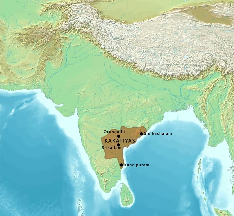
Kakatiya Empire at Its 13th-Century Zenith
Introduction
From the dry uplands of northern Telangana, the Kakatiyas extended their authority toward the fertile Telugu-speaking deltas of the Godavari and Krishna. This geographic connection is the central feature of the map: it represents not simply an expanding kingdom, but the political integration of upland and lowland regions that had previously developed through different social and economic patterns.
The map is set during the 13th-century expansion associated especially with Ganapati Deva, who ruled approximately from 1199 to 1262 CE. During the 1230s, he brought the lowland delta regions around the Godavari and Krishna under Kakatiya control. The dynasty’s power was centred on Orugallu, the city now known as Warangal, while Anumakonda—modern Hanamkonda—had earlier served as an important Kakatiya centre and hereditary fief.
Kakatiya territory at this height covered much of present-day Telangana and Andhra Pradesh, with influence or territorial claims extending into parts of eastern Karnataka, northern Tamil Nadu, and southern Odisha. The precise line between directly governed land, subordinate territories, military influence, and tributary relationships cannot always be drawn with certainty. The map therefore presents a broad historical configuration rather than a modern-style border fixed at every point.
Historical Context
From feudatories to sovereign rulers
The Kakatiya dynasty emerged within the political world of the eastern Deccan, where authority was divided among major imperial powers, regional kingdoms, and local chiefs. The earliest Kakatiya rulers served as feudatories of the Rashtrakutas and later of the Western Chalukyas, also known as the Kalyani Chalukyas, for more than two centuries.
The dynasty’s early history is known mainly through inscriptions, and the regnal dates of several early chiefs remain approximate. Venna or Vanna, who ruled around 800–815 CE, is identified in Kakatiya records as an ancestor descended from the legendary chief Durjaya. His successors included Gunda I, Gunda II, Gunda III, Erra, Betiya, and Gunda IV. The 9th- and 10th-century record connects these early chiefs with military service and territorial administration in the Telugu-speaking region.
A 956 CE inscription from Mangallu indicates that the Kakatiyas were connected with Rashtrakuta military power. The exact nature of that connection is debated. One interpretation holds that the term “Rashtrakuta” attached to the names of early Kakatiya chiefs indicated subordination to the Rashtrakuta state. Another interpretation sees the Kakatiyas as a branch of the Rashtrakuta family. The surviving evidence does not resolve the question conclusively.
The decline of Rashtrakuta power changed the political framework of the Deccan. The Kakatiyas then served the Kalyani Chalukyas. Beta I accepted Chalukya suzerainty and received Anumakonda as a fief. His successor Prola I consolidated Kakatiya authority around that centre and participated in Chalukya military campaigns. Later chiefs held territories such as Sabbi-1000, a historical region centred around Vemulavada.
The move toward sovereignty
Prola II was the last Kakatiya ruler whose surviving inscription clearly presents him as a feudatory. His reign is generally placed around 1116–1157 CE, although the chronology of the period is not uniform in all historical reconstructions. His efforts to expand Kakatiya influence brought him into conflict with other regional powers. He died in a battle against the Velanati Choda ruler Gonka II around 1157 or 1158.
Prola II’s son Rudradeva, also known as Rudra Deva and Prataparudra I, marked the decisive transition from subordinate chiefdom to independent monarchy. His 1163 inscription at Anumakonda is the earliest known record describing the Kakatiyas as a sovereign power. From this period onward, Kakatiya inscriptions were increasingly written in Telugu rather than Kannada, reflecting the dynasty’s political and cultural orientation in the Telugu-speaking region.
Rudradeva ruled approximately from 1158 or 1163 until 1195 CE, depending on the chronology followed. He suppressed other Chalukya subordinates in the Telangana region and established the political basis for later Kakatiya expansion. Mahadeva succeeded him and ruled for a short period, probably from about 1195 to 1199.
Ganapati Deva and the territorial high point
Ganapati Deva’s long reign, conventionally dated approximately 1199–1262 CE, was the principal period of Kakatiya territorial expansion. During the 1230s, Kakatiya armies and administrators moved beyond the dynasty’s traditional Telangana base and brought the lowland delta regions around the Godavari and Krishna under their control.
This expansion gave the Kakatiya kingdom a broader geographic and economic foundation. The uplands around Orugallu and Anumakonda were comparatively dry and required substantial investment in reservoirs and irrigation. The deltas, by contrast, were more densely settled and agriculturally productive. Their incorporation connected different agrarian and social systems within a single political framework.
Ganapati Deva also strengthened Orugallu. The capital had been established there around 1195 CE, and he organised the construction of a massive granite wall, ramps, bastions, and a moat. The city became both a royal residence and a military centre from which the expanded kingdom could be administered.
His policy was not confined to warfare. Ganapati encouraged long-distance commerce, abolished taxes other than a fixed duty, and supported merchants who travelled abroad. The available historical record does not identify a complete list of overseas destinations, ports, commodities, or formal trade roads, but these policies indicate that commercial activity formed part of the kingdom’s political economy.
Rudrama Devi
Rudrama Devi succeeded Ganapati Deva and ruled approximately from 1262 to 1289 CE, although alternative dates place her reign somewhat differently. She was one of the few queen regnants in Indian history. Her position demonstrates that succession and sovereignty within the Kakatiya dynasty could take forms that did not conform to the usual pattern of male kingship.
The exact relationship between Rudrama Devi and Ganapati Deva is described differently in historical accounts: some identify her as his daughter, while others have treated her as his widow. She was married to Virabhadra, an Eastern Chalukyan prince of Nidadavolu selected for the marriage by Ganapati Deva.
Rudrama continued the fortification of Orugallu. She raised the height of Ganapati’s granite wall and added a second earthen curtain wall approximately 1.5 miles, or 2.4 kilometres, in diameter. This outer defensive system was accompanied by an additional moat about 150 feet, or 46 metres, wide.
Her reign also involved conflict with the Yadavas, or Seunas, of Devagiri. A fragmentary Kannada inscription records that the Kakatiya general Bhairava defeated a Yadava army, probably during or after 1263 CE. Rudrama successfully resisted Yadava attacks into Kakatiya territory, preserving the kingdom’s position in the Deccan.
Prataparudra II and the end of the dynasty
Prataparudra II succeeded Rudrama Devi. His reign began in 1289 or, according to an alternative chronology, 1295, and ended with the fall of the Kakatiya kingdom in 1323. During his reign, the kingdom confronted the expanding power of the Delhi Sultanate.
The first major Delhi Sultanate expedition into Kakatiya territory took place in 1303. Malik Chajju and Fakhruddin Jauna led the invasion, but the campaign ended in disaster for the invading army because of Kakatiya resistance, particularly at the Battle of Upparapalli.
A further campaign led by Malik Kafur produced a different result. After a month-long siege, Orugallu fell in February 1310. Prataparudra was not removed from power, but he was compelled to acknowledge a subordinate position and pay annual tribute to Delhi. The tribute reportedly included horses and elephants, and the transfer of the Koh-i-Noor diamond from Kakatiya possession to Alauddin Khalji is associated with this submission.
Prataparudra later failed to provide the required tribute, explaining that the journey was unsafe because of the risk of attack. In 1318, forces under Khusrau Khan were sent against Orugallu. Prataparudra submitted again, and the tribute was altered to 100 elephants and 12,000 horses.
When political upheaval removed the Khalji dynasty and Ghiyasuddin Tughlaq became sultan, Prataparudra again asserted independence. Tughlaq sent his son, Jauna Khan, against the Kakatiyas in 1321. Internal dissension and rumours of the king’s death initially weakened the expedition, and the invading army withdrew to Devagiri. Jauna Khan returned in 1323 with a reinforced army. After a five-month siege, Orugallu fell. The city was renamed Sultanpur, and the Kakatiya dynasty came to an end.
Some accounts state that Prataparudra died near the Narmada River while being taken prisoner to Delhi, possibly by suicide. The precise circumstances remain tied to differing historical accounts.
Territorial Extent and Boundaries
The Kakatiya heartland
The Kakatiya political base lay in the dry uplands of northern Telangana on the Deccan Plateau. Orugallu was the principal capital, while Anumakonda-Hanamkonda represented an earlier centre of Kakatiya authority. This upland core formed the administrative, military, and ideological centre of the dynasty.
The dry character of the region made water management crucial. Kakatiya rulers and subordinate warrior families constructed reservoirs, often called tanks, to retain water and support agriculture. These works were not peripheral to territorial control. They helped make the uplands more productive, anchored settlements, and tied local elites to the dynasty.
Northern and northeastern reach
The broadest 13th-century description of Kakatiya territory extends toward Kalyani in the north or northeast and into southern Odisha, including the Ganjam district region. The exact status of every area within this wider zone is not uniform in the surviving record. Some territories may have been directly controlled, while others were connected through subordinate chiefs, military campaigns, or tribute.
The map uses a graduated territorial treatment for these areas rather than implying a sharply surveyed frontier. Medieval political authority often depended on personal allegiance, military capacity, tribute, and control of strategic centres rather than on a continuous boundary line.
Eastern and southeastern expansion
The most significant expansion under Ganapati Deva was toward the lowlands around the Godavari and Krishna rivers. These delta regions formed the eastern extension of the Kakatiya kingdom toward the Bay of Bengal.
The deltas were not merely additional territory. They contained established settlements, agricultural communities, religious institutions, and networks of local power. Their integration required the Kakatiyas to bind powerful regional figures into allegiance. The relationship between upland capital and lowland society helped create a wider political identity among Telugu speakers.
The kingdom’s territory also extended toward northern Tamil Nadu, according to broad descriptions of Kakatiya rule. The available record does not provide a detailed sequence of every conquest or a complete list of administrative districts in that direction. The map therefore marks this extension as part of the dynasty’s wider sphere rather than presenting a precise internal boundary.
Southern and western reach
At its widest 13th-century extent, Kakatiya power reached close to Anagondi in the west and toward Kanei and Ganjam district in the south and southeast. These points describe the broad geographical range of the kingdom during its height.
Parts of eastern Karnataka and northern Tamil Nadu are included in descriptions of Kakatiya territory. The western Deccan was also a zone of interaction with the Yadavas of Devagiri and other regional powers. Kakatiya authority in such frontier areas could be affected quickly by warfare, changing alliances, and the strength of local chiefs.
Direct territory, subordinate chiefs, and tributaries
The Kakatiya state grew through several forms of political relationship. In the early period, the dynasty itself was subordinate to the Rashtrakutas and Kalyani Chalukyas. After sovereignty was declared in the 12th century, Kakatiya rulers continued to govern through local chiefs, military commanders, and hereditary elites.
Inscriptions reveal the importance of subordinate families and warrior leaders. The Kakatiyas integrated local powers by granting titles, land, offices, and opportunities for military service. The nayaka title could be acquired regardless of birth and denoted warrior status. This helped extend the dynasty’s influence into areas where direct bureaucratic administration may not have been practical.
The relationship with the Delhi Sultanate after 1310 illustrates another form of political connection. Prataparudra remained ruler of the region but paid annual tribute to Delhi. The kingdom was therefore not immediately annexed after the first successful siege. Its political status changed from independent monarchy to tributary subordination before the final conquest of 1323.
Administrative Structure
The capital at Orugallu
Orugallu, now Warangal, was the centre of Kakatiya political power. The city was also called Kakati-pura, or “Kakati town,” in some inscriptions. Its fortifications show that the capital served as a major military stronghold as well as a royal and ceremonial centre.
Ganapati Deva developed a massive granite wall around the city. The wall included ramps designed to give defenders access to the ramparts from within the city, together with bastions and a moat. Rudrama Devi later strengthened the existing fortifications and added a second earthen curtain wall with another moat.
This layered defensive design reflects the political importance of Orugallu. The capital protected the royal household, military stores, administrative offices, and the symbolic centre of Kakatiya sovereignty. Its fall in 1323 therefore represented more than the capture of a city: it marked the collapse of the dynasty’s central political structure.
Anumakonda and regional administration
Anumakonda, modern Hanamkonda, was granted to Beta I as a fief by the Kalyani Chalukyas. It became an important Kakatiya centre before the development of Orugallu as the principal capital. The Thousand Pillar Temple at Hanamkonda remains a prominent reminder of the region’s importance during the dynasty’s period of sovereignty.
The Kakatiya kingdom was not governed solely from the capital. Local chiefs, military commanders, temple authorities, and landed elites played important roles in managing territory. The state’s growth depended on incorporating locally powerful figures into a hierarchical political order.
Kakatiya inscriptions record donations, grants, military achievements, genealogies, and religious endowments. Around 1,000 stone inscriptions and 12 copper-plate inscriptions are associated with the period, although many records have been lost through the destruction or decay of buildings and monuments. The surviving epigraphic evidence is especially abundant for approximately 1175–1324 CE.
Warrior families and the nayaka system
The Kakatiya political order was closely connected with military recruitment. Peasants were recruited into the army, helping create a new warrior class and offering a degree of social mobility. The nayaka title denoted warrior status and was not restricted entirely by birth.
This system helped the dynasty govern a geographically varied kingdom. Warrior families could maintain local influence while remaining connected to the central monarchy through military obligations, grants, and political allegiance. The dilution of older landed nobility was encouraged by royal gifts of land to people of lower status.
The result was a more fluid political society than the rigid model sometimes used to describe pre-colonial India. Kakatiya inscriptions suggest that occupation was an important marker of social position, but people were not necessarily bound to the occupation of their birth. Caste identities existed, yet they do not appear to have operated as the sole basis of political or military organisation.
Temples, tanks, and authority
Temples were important institutions in both the uplands and lowlands. In the densely settled delta areas, well-established temples could support social networks linked to domestic and overseas trade, landholding, and grazing rights. In the uplands, temple endowment was connected with the creation and maintenance of reservoirs and with the development of political hierarchies.
The construction of a temple and the construction of a tank could therefore be part of the same process of territorial development. Reservoirs supported settlement and agriculture; temples helped organise patronage, authority, and social relationships. The Kakatiya state expanded not only through conquest but also through these interlocking institutions.
Infrastructure and Communications
Irrigation tanks
The most clearly documented Kakatiya infrastructure was the construction of irrigation reservoirs in the uplands. Around 5,000 tanks are associated with the period, many built by warrior families subordinate to the dynasty. Large examples include the reservoirs at Pakhal and Ramappa.
These tanks transformed the productive possibilities of dry areas. By retaining water, they supported agricultural settlement in landscapes where cultivation was more difficult and uncertain. Their construction also strengthened the relationship between the Kakatiya state and local military families, whose authority was tied to the creation and maintenance of productive landscapes.
Many of these reservoirs remained in use long after the Kakatiya period. Their survival gives the dynasty’s territorial history a material dimension: the boundaries of Kakatiya influence can be studied not only through inscriptions and forts but also through water systems that continued to shape rural life.
Fortifications
Orugallu’s defensive works were the most ambitious expression of Kakatiya military infrastructure. Ganapati Deva’s granite wall, ramps, bastions, and moat were later reinforced by Rudrama Devi. The second curtain wall and its broad moat created a further defensive perimeter around the capital.
The design allowed access to the ramparts from inside the city, suggesting attention to the practical movement of defenders. The fortifications also communicated royal power. A heavily defended capital demonstrated the dynasty’s ability to mobilise labour, stone, engineering knowledge, and military organisation.
Warangal Fort and the wider Orugallu complex became central targets in the campaigns of the Delhi Sultanate. The long sieges of 1310 and 1323 show how the city’s defences shaped the course of warfare.
Trade and merchant policy
Ganapati Deva encouraged merchants to trade abroad. He abolished taxes other than a fixed duty and supported those who travelled long distances at personal risk. These measures indicate an attempt to create a predictable commercial environment across the kingdom.
The surviving account does not provide a complete map of Kakatiya roads, ports, shipping routes, or commercial commodities. It also does not identify a formal postal service. For this reason, the map does not draw speculative highways or maritime routes. Instead, it presents the Godavari and Krishna lowlands as important geographic corridors within the expanded kingdom and identifies the general commercial orientation of Ganapati’s policies.
The location of the Kakatiya kingdom between the Deccan interior and the Bay of Bengal gave it access to both inland and lowland networks. The integration of uplands and deltas would have connected different economic zones, although the precise mechanisms and volume of trade are not established by the available record.
Communications and political integration
Communication across the kingdom depended on the movement of rulers, armies, officials, merchants, religious specialists, and local chiefs. Military recruitment extended Kakatiya influence into communities that had previously remained outside the effective reach of the dynasty. Temple endowments and reservoir construction created additional links between the capital and the countryside.
The shift from Kannada to Telugu in Kakatiya inscriptions after sovereignty was declared in 1163 also reflects a change in political communication. Written records increasingly addressed the linguistic and cultural world of the Telugu-speaking region. This did not erase local variation, but it helped express the dynasty’s relationship with Telugu lands.
Economic Geography
Upland agriculture
The Kakatiya core was located in the dry uplands of the Deccan Plateau. Agricultural development there depended heavily on water management. The construction of reservoirs made it possible to support more settled communities and expand cultivation.
The tanks associated with the Kakatiya period were therefore economic as well as engineering projects. Their construction affected settlement, land use, local authority, and military organisation. Warrior families who built or maintained reservoirs gained a role in the political economy of the kingdom.
The expansion of agriculture also contributed to the growth of a settled peasant class. Many tribal communities that had previously been nomadic became incorporated into settled agrarian society. This transformation changed the demographic and political geography of the uplands.
Godavari and Krishna deltas
The lowlands around the Godavari and Krishna rivers formed the most important economic addition to the Kakatiya kingdom during Ganapati Deva’s expansion. These delta regions were more densely populated than the uplands and contained long-established centres of agrarian and religious activity.
The Kakatiya achievement lay partly in connecting these environments. The uplands supplied the political and military base, while the lowlands offered fertile agricultural regions and established networks of settlement. Cultural influence moved in both directions: innovations that began in the uplands could be refined in the lowlands and then return to the Deccan.
The record characterises the Godavari lowlands as associated with peasants, artisans, and warriors, while the Krishna and Godavari delta areas also contained significant Brahmanical institutions. These distinctions should not be treated as absolute, but they show that the kingdom contained different social landscapes.
Commerce
Ganapati Deva’s removal of most taxes and retention of a fixed duty was designed to encourage trade. Merchants who travelled abroad were supported, suggesting that the state recognised the value and danger of long-distance commerce.
No securely documented list of principal Kakatiya ports or export commodities is available here. It is therefore more accurate to describe the kingdom as commercially connected than to assign it a detailed maritime network. The eastern orientation of the Godavari and Krishna regions placed the Kakatiyas in a position to interact with coastal and overseas trade, but the exact routes require evidence beyond the material considered for this map.
Land grants and temple economies
Land grants were important instruments of Kakatiya rule. Inscriptions frequently record religious donations, especially gifts to Hindu temples. Such grants helped establish political relationships and supported the ritual institutions that legitimised royal authority.
In the lowlands, temples could assist in organising networks connected with trade, land, and grazing rights. In the uplands, temple endowments were often connected with the building and maintenance of reservoirs. Economic geography was therefore inseparable from religious and political patronage.
Cultural and Religious Geography
Telugu cultural integration
The Kakatiyas unified distinct upland and lowland cultures within the Telugu-speaking region. This integration helped produce a broader cultural affinity among Telugu speakers, a development described as one of the dynasty’s most significant political achievements.
The process was not simply linguistic. It involved the movement of people, military service, temple patronage, agricultural settlement, and political allegiance. The Kakatiya state brought together communities with different economic roles and regional histories.
The use of Telugu in inscriptions after the dynasty’s declaration of sovereignty in 1163 is a visible sign of this political reorientation. Sanskrit continued to be used in inscriptions and literary works, but Telugu became increasingly important for expressing royal authority in the kingdom’s regional context.
Architecture
Kakatiya architecture developed distinctive forms by improving and innovating upon existing modes. Major examples include:
- The Thousand Pillar Temple at Hanamkonda.
- The Ramappa Temple at Palampet.
- Warangal Fort.
- Golconda Fort.
- Kota Gullu at Ghanpur.
These monuments should be understood within a wider landscape of temples, reservoirs, forts, and settlements. The architectural style was supported by royal patronage, local donors, military elites, and temple institutions.
The relationship between architecture and water management is particularly important. In the uplands, the construction and maintenance of temples could be linked to reservoirs. Religious buildings were therefore part of the infrastructure through which political authority and agrarian society were organised.
Jainism and Shaivism
The religious history of the Kakatiyas involved both Jain and Shaiva traditions. Historian P. V. P. Sastry proposed that the early Kakatiya chiefs may have followed Jainism. This interpretation draws on accounts involving the goddess Padmavati or Padmakshi and on possible connections between the Kakatiyas, the Rashtrakutas, and Jain religious traditions.
The evidence is not decisive. Kakatiya inscriptions also record a later association with Shaivism. According to tradition, Prola II was initiated into Shaivism by the Kalamukha preceptor Ramesvara Pandita, after which Shaivism became the family’s religion. The Shaiva names of later rulers—including Rudra, Mahadeva, Harihara, and Ganapati—are consistent with this shift.
The historical record therefore suggests religious change and complexity rather than a single unaltered dynastic identity. A 15th-century commentary associated the family name with a tutelary goddess named Kakati, identified as a form of Durga. The worship of Kakatamma, or “Mother Kakati,” is also attested in literary and inscriptional evidence. One theory proposes that Kakati may originally have been a Jain goddess, possibly Padmavati, later regarded as a form of Durga. This remains a theory rather than an established conclusion.
Orugallu as a sacred and political centre
Orugallu was not only the administrative capital. Inscriptions and later literary references associate it with the worship of Kakatamma and with the symbolic identity of the Kakatiya kingdom. The name Kakati-pura, “Kakati town,” links the capital to the dynasty’s political and religious traditions.
The city’s temples, fortifications, royal institutions, and ritual associations made it the central expression of Kakatiya sovereignty. When the city fell and was renamed Sultanpur in 1323, the change represented the replacement of the dynasty’s political and symbolic centre.
Military Geography
The upland capital and defensive depth
The location of Orugallu in the dry Telangana uplands gave the Kakatiyas a defensible base in the Deccan Plateau. The city’s extensive fortifications created multiple layers of defence. A massive granite wall, bastions, ramps, and a moat were supplemented under Rudrama Devi by a second earthen curtain wall and another broad moat.
The defensive system was designed to withstand prolonged attack. The campaigns of the Delhi Sultanate demonstrate its importance. Malik Kafur’s siege in 1310 lasted a month, while Jauna Khan’s final siege in 1323 lasted five months. The length of the latter siege was influenced by the condition of the attacking and defending armies, the availability of supplies, and the changing strength of the besieging force.
The army and warrior society
Kakatiya military power depended on local warrior families and the recruitment of peasants. The ability to acquire the nayaka title regardless of birth helped create a warrior class with links to the royal state. This military organisation also promoted social mobility and extended Kakatiya control into regions that might otherwise have remained outside the dynasty’s effective authority.
The kingdom’s army was not a detached institution separate from society. Military recruitment helped transform the population of the uplands, incorporating settled peasants and formerly nomadic groups into a wider political order. Subordinate chiefs and commanders connected local power to the central monarchy.
The historical record does not provide a reliable general estimate of the Kakatiya army’s total size. It does, however, record tribute demands imposed by the Delhi Sultanate after the conquest of Orugallu: at one stage, 20,000 horses and 100 elephants were associated with the transfer of wealth, while later annual tribute was fixed at 100 elephants and 12,000 horses. These figures describe tribute and military resources, not the complete size of the Kakatiya army.
Conflict with the Yadavas
The Yadavas, or Seunas, of Devagiri were among the Kakatiyas’ principal western and northwestern rivals. Rudrama Devi successfully repelled Yadava attacks into Kakatiya territory. A fragmentary Kannada inscription records a victory by the Kakatiya general Bhairava over a Yadava army, probably in or after 1263 CE.
The conflict demonstrates the strategic importance of the Deccan frontier. The Kakatiyas had to defend their upland base while maintaining control over the routes and subordinate regions linking Telangana with the broader Deccan.
The Delhi Sultanate campaigns
The 1303 invasion led by Malik Chajju and Fakhruddin Jauna ended in failure for the Delhi Sultanate. Kakatiya resistance at Upparapalli prevented the expedition from achieving its objective.
Malik Kafur’s campaign of 1309–1310 was more successful. The month-long siege of Orugallu compelled Prataparudra II to accept subordination and tribute. The Kakatiya state survived, but its political independence was restricted.
Prataparudra’s refusal or inability to pay tribute led to another campaign in 1318. Khusrau Khan’s army used advanced siege technology, including trebuchet-like machines previously unfamiliar in the region. Prataparudra submitted again.
The final campaign began in 1321 under Jauna Khan, later associated with the Tughlaq dynasty. Internal dissension initially forced the besieging army to retreat to Devagiri. Its return in 1323, with greater strength and renewed supplies, produced the fall of Orugallu. The Kakatiya kingdom was absorbed into the expanding political order of the Delhi Sultanate.
Political Geography
Relations with the Rashtrakutas and Chalukyas
The Kakatiyas first rose as subordinate chiefs within larger Deccan empires. Their early links with the Rashtrakutas are visible in inscriptions that associate Kakatiya ancestors with military command and administration. Whether the Kakatiyas were a branch of the Rashtrakuta family or merely served the Rashtrakutas remains debated.
After the decline of Rashtrakuta power, the Kakatiyas served the Kalyani Chalukyas. Beta I’s receipt of Anumakonda as a fief shows how the dynasty’s territorial base developed through service to a superior power. Prola I participated in Chalukya campaigns and strengthened Kakatiya authority around Anumakonda.
The eventual decline of Chalukya power allowed the Kakatiyas to assert sovereignty. Rudradeva’s 1163 inscription marks the public expression of this change.
The Velanati Chodas and other regional powers
The Kakatiyas competed with the Velanati Chodas and other regional dynasties for control of the eastern Deccan. Prola II died in conflict with the Velanati Choda ruler Gonka II while attempting to expand Kakatiya influence eastward.
Ganapati Deva’s later expansion into the Godavari and Krishna lowlands changed the balance of power in the Telugu region. The Kakatiyas connected the uplands and lowlands by bringing local political figures into allegiance and extending military and administrative influence beyond the original Telangana core.
Yadavas and the Deccan balance
The Yadavas of Devagiri were a major neighbouring power. Their attacks during Rudrama Devi’s reign were successfully resisted. The frontier between the two kingdoms was therefore a zone of active military competition rather than a stable line.
The Kakatiya kingdom was one of four major Hindu monarchies that dominated much of South India and the Deccan during the 13th century. These states were in continual conflict with one another. The Kakatiyas’ territorial height must be understood within this competitive regional system.
Subordination to Delhi
The relationship with the Delhi Sultanate changed in stages. The failed invasion of 1303 was followed by the successful siege of 1310. Prataparudra remained on the throne but became a subordinate ruler obligated to pay tribute.
The tribute arrangement preserved a degree of local royal authority for a time. It also exposed the Kakatiya state to repeated intervention from Delhi. When Prataparudra attempted to restore independence after changes in Delhi’s ruling dynasty, the Tughlaq state responded with renewed military campaigns.
The final conquest in 1323 ended Kakatiya sovereignty. Yet Delhi’s control of the region lasted only around a decade. The political structure left by the Kakatiyas disintegrated, and the territory soon came under the control of multiple local families and successor powers.
Legacy and Decline
The collapse of the kingdom
The fall of Orugallu in 1323 ended the Kakatiya dynasty and brought the territory into the Delhi Sultanate’s sphere. The collapse produced political confusion and cultural disarray. The earlier system of royal authority, local warrior allegiance, temple patronage, and regional administration broke apart.
Delhi’s control did not remain permanent. By about 1330, Musunuri Nayaks, who had served as Kakatiya army chiefs, united Telugu clans and recovered Warangal from the Delhi Sultanate. They ruled for roughly half a century.
The former Kakatiya lands then became divided among new political formations, including the Reddies and Velamas. By the 15th century, these entities had ceded territory to the Bahamani Sultanate and the Sangama dynasty, which later developed into the Vijayanagara Empire.
Memory and political legitimacy
The memory of the Kakatiya kingdom continued to shape later political claims. A 1330 inscription presents Prolaya Nayaka as a restorer of order in the manner of Prataparudra. This portrayal gave a successor ruler legitimacy by connecting him with the last independent Kakatiya king.
Later traditions also linked the Kakatiyas with the ruling family of Bastar. The historical basis of this connection is uncertain, and the genealogy supporting it was published much later, in 1703. Such claims could legitimise the right to rule and reinforce warrior status.
The 16th-century Prataparudra Caritramu developed an even more elaborate memory of Prataparudra II. Contrary to accounts that place his death during captivity, it portrays him as returning to Orugallu after meeting the sultan and being recognised as an incarnation of Shiva. It also presents him as the founder of the Padmanayaka warrior class. These claims are not consistent with the broader historical evidence, but they show how the Kakatiya past was adapted to later political needs.
Enduring landscapes
The most durable legacy of the Kakatiyas lies in the landscapes they reshaped. Tanks and reservoirs altered agriculture in the dry uplands. Forts and temples preserved the political and artistic character of the dynasty. Warangal and Hanamkonda remained closely associated with Kakatiya history, while the Ramappa Temple, Thousand Pillar Temple, Warangal Fort, Golconda Fort, and Kota Gullu represent the architectural achievements of the period.
The dynasty also left a cultural legacy in the integration of Telugu-speaking uplands and lowlands. Its political project helped create a stronger sense of affinity among Telugu speakers, even though the kingdom itself was later divided among successor states.
This map should therefore be read as a reconstruction of a political moment rather than a depiction of a permanent national boundary. Kakatiya authority expanded through conquest, tribute, land grants, military service, irrigation, temple patronage, and relationships with local chiefs. At its 13th-century height, the kingdom joined the Telangana plateau to the Godavari and Krishna lowlands and connected regional political power with a wider Telugu cultural geography.