Madurai Nayaka Kingdom, 1529–1736
Introduction
The Madurai Nayaka map is defined by a political transition: a former Vijayanagara provincial command in the far south became a largely independent kingdom centred on Madurai. The dynasty began when Viswanatha Nayaka was appointed governor of Madurai and the other Tamil provinces in 1529. Over the next two centuries, its territory and political influence extended across much of modern southern and western Tamil Nadu, while its rulers negotiated with, fought, or paid tribute to Vijayanagara, Mysore, Travancore, Thanjavur, Gingee, Kandy, Golconda, Bijapur, and the Mughal power advancing into southern India.
The boundaries shown on a historical map of the Madurai Nayakas must therefore be read as changing political zones rather than as fixed modern-style frontiers. Direct administration, tribute, military protection, local chieftainship, and temporary occupation all formed part of the kingdom’s geography. Madurai was the principal capital, although Muttu Virappa Nayaka shifted the capital to Tiruchirappalli in 1616, and Tirumala Nayaka later returned it to Madurai, completing the transfer in 1635.
The dynasty is associated especially with Viswanatha Nayaka, Krishnappa Nayaka, Muttu Krishnappa Nayaka, Tirumala Nayaka, Rani Mangammal, Chokkanatha Nayaka, and Queen Meenakshi. Its political history ended in 1736, when Chanda Sahib seized Tiruchirappalli, imprisoned Meenakshi, and displaced the last effective Nayaka government.
Historical Context
From Vijayanagara province to Nayaka rule
The southern Tamil country had long been difficult for the Vijayanagara Empire to control because of its distance from the imperial centre. It was brought more fully under imperial authority in the early sixteenth century. The first Nayaka associated with the region was Nangama Nayaka, a Telugu-speaking Balija warrior and general sent south by Krishnadevaraya with a large army to restore imperial authority over Pandya Nadu.
Nangama was regarded as an able administrator, but his harsh rule alienated local chieftains. He also began to resist central orders while continuing to claim authority as the emperor’s deputy. Krishnadevaraya responded by sending Nangama’s son, Viswanatha Nayaka, with another army. Viswanatha defeated his father and sent him to the imperial court as a prisoner. Krishnadevaraya later pardoned Nangama because of his earlier service and appointed Viswanatha governor of Madurai and the surrounding Tamil provinces in 1529.
A different account says that Nangama had been sent to restore the Pandya king after a Chola attack, but instead took the throne for himself. That version lacks epigraphic support and should be treated as a later or competing tradition rather than a confirmed explanation.
Viswanatha Nayaka and territorial consolidation
Viswanatha initially ruled as a governor rather than as an independent monarch. His authority included Chola Nadu for a time, but that area was later transferred to the Thanjavur Nayakas. In 1544, he assisted Rama Raya’s army in suppressing Travancore’s refusal to pay tribute.
Within the Madurai region, Viswanatha rebuilt fortifications and made travel safer. He cleared jungle along the Kaveri near Tiruchirappalli and destroyed robber hideouts there. By the end of his life, his authority had expanded to include most of modern southern and western Tamil Nadu, although many local chiefs remained reluctant to accept centralized rule.
To manage this difficult political landscape, Viswanatha and his chief minister Ariyanatha Mudaliar developed the palayam, or poligar, system. The Pandyan country was divided into 72 palayams, each governed by a palaiyakkarar. These local warrior-chiefs retained substantial autonomy in return for revenue and military obligations. The system gave the Nayaka state reach across a large and varied territory, but it also left the centre dependent on local power-holders.
The early succession
Viswanatha’s son Krishnappa was crowned in 1564. He immediately faced opposition from nobles dissatisfied with the palayam arrangement. A revolt led by Tumbichchi Nayaka was suppressed. In the same year, Krishnappa sent a contingent to the Battle of Talikota, although it arrived too late to affect the outcome. The defeat of Rama Raya at Talikota weakened Vijayanagara authority and made the Nayakas substantially more independent.
Krishnappa also intervened in Kandy when its ruler stopped sending tribute. He invaded the island kingdom, killed its king, transferred the royal family to Anuradhapura, and installed his brother-in-law Vijaya Gopala Naidu as viceroy. This episode demonstrates that the political geography of Madurai extended beyond the mainland through military and tributary connections.
After Krishnappa’s death in 1572, Virappa Nayaka ruled during a period of relative stability. His relations with the weakened Vijayanagara court varied according to the strength of the imperial government but were generally cordial. He also suppressed a revolt by polygars claiming descent from the Pandyas. Krishnappa Nayaka II followed him in 1595, occupied Travancore, and recognized Venkatapati Raya as emperor of Vijayanagara.
Coastal organization and the road to independence
A succession crisis followed the death of Krishnappa Nayaka II in 1601. Kasturi Rangappa seized the throne but was assassinated after about a week. Muttu Krishnappa Nayaka, the son of Krishnappa’s second brother, then became ruler. His reign focused especially on the southern coast, where fishing and pearl diving created important revenue opportunities.
The coast had been neglected by earlier Nayakas and had become increasingly lawless. Portuguese authority also expanded there. When Portuguese officials claimed the coast and began collecting taxes, Muttu Krishnappa sent Sethupathis to the Ramanathapuram region. Their responsibilities included protecting pilgrims travelling to Rameswaram and compelling the Portuguese to recognize Nayaka authority. Muttu Krishnappa is credited with establishing the Sethupathi dynasty in Ramnad.
Muttu Virappa Nayaka succeeded his father in 1609. Seeking greater independence from Vijayanagara, he stopped paying tribute regularly. The succession crisis that followed the murder of Sriranga II and his family in 1614 drew Madurai into a wider conflict. Madurai, Gingee, and the Portuguese supported Jagga Raya, while Thanjavur and Kalahasti supported Rama Deva Raya. At the Battle of Toppur in 1616, Jagga Raya’s forces were defeated. Muttu Virappa was compelled to pay a substantial tribute and moved his capital to Tiruchirappalli, partly to facilitate an attack on Thanjavur.
Tirumala Nayaka and the height of power
Muttu Virappa died in 1623 and was succeeded by his brother Tirumala Nayaka. Tirumala moved the capital back to Madurai, both because it offered better protection against invasion and because of Madurai’s religious importance. The transfer took ten years and was completed in 1635. He also expanded the army to approximately 30,000 men.
Mysore invaded in 1625, but Tirumala and his generals Ramappayya and Ranganna Nayaka defeated the invasion and counterattacked, laying siege to Mysore. In 1635, Travancore stopped paying tribute, prompting another Nayaka campaign that forced the resumption of payments. Tirumala also sent Ramappayya against the Sethupathi of Ramnad after a dispute over succession. Portuguese support helped Tirumala in this campaign, and in return he permitted the Portuguese to construct a fortress and station a small garrison wherever they wished.
As Vijayanagara declined, Tirumala cancelled tribute payments altogether. Sriranga III attempted to reassert imperial authority and assembled an army against Madurai. Tirumala allied with Thanjavur and Gingee, although Thanjavur later defected. Madurai then allied with Golconda, whose forces besieged Vellore and defeated Sriranga III. When Sriranga appealed to the Nayakas, they refused to support him, and Vijayanagara fell as an effective political power.
Golconda conquered Vellore around 1646 and joined Bijapur in besieging Gingee. Tirumala’s army arrived too late to save the fortress. In 1655, Mysore again invaded while Tirumala was ill. He entrusted the defence to the Sethupathi of Ramnad, and Ragunatha Thevar drove the Mysorean army back. The tribute obligation of Ramnad was cancelled in recognition of this service.
Territorial Extent and Boundaries
The Madurai Nayaka kingdom occupied the southern Tamil region, but its precise limits changed across the two centuries of its existence. The broadest description supported by the historical record is that Viswanatha Nayaka’s authority came to include most of modern southern and western Tamil Nadu. The kingdom’s political geography included the Madurai heartland, the Kaveri corridor around Tiruchirappalli, the southern coast and Ramanathapuram region, and inland areas organized through the 72 palayams.
Northern and eastern zones
The northern limit was not permanent. The kingdom’s relationship with Thanjavur, Gingee, and the remaining Vijayanagara territories shifted repeatedly. Chola Nadu was initially under Viswanatha’s control but was transferred to the Thanjavur Nayakas. Muttu Virappa later fought in the Thanjavur succession and moved his capital to Tiruchirappalli partly to make an invasion of Thanjavur easier.
Gingee and Vellore were especially important in the wider political geography of the seventeenth century. They were not simply permanent parts of the Madurai kingdom. Instead, they were connected to the succession struggles and military alliances surrounding the disintegration of Vijayanagara. Golconda’s conquest of Vellore and its siege of Gingee revealed how quickly authority in the eastern and northern Tamil zones could move beyond Madurai’s control.
Southern and coastal zones
The southern coast was a major concern of the Nayaka state. Fishing and pearl diving generated revenue, while the route to Rameswaram carried pilgrims. The establishment of Sethupathi authority around Ramanathapuram was both a fiscal and military measure. Sethupathis were expected to protect pilgrims and defend Nayaka claims against Portuguese taxation.
The coastal zone was not uniformly administered from Madurai. Portuguese influence was strong in places, and Tirumala’s agreement permitting a Portuguese fortress and garrison shows that European commercial and military presence formed part of the regional balance. Dutch and Portuguese merchants conducted much of the foreign trade associated with the kingdom; British and French influence had not yet become established in the region during the period described here.
Western frontier
The western frontier touched the political worlds of Travancore and Mysore. Travancore repeatedly withheld tribute and was attacked or compelled to resume payments. Mysore invaded the Madurai sphere in 1620, 1625, and 1655. These campaigns show that the western boundary was a militarized zone rather than a fixed line.
The natural geography included uplands, forested tracts, and routes across the Tamil interior. Viswanatha’s clearing of jungle near the Kaveri and Tirumala’s large army indicate the importance of securing movement through these landscapes.
Tributary and dependent regions
The Nayaka kingdom depended on several different forms of political connection. Some areas were directly governed through provincial officials and local bureaucracies. Others were assigned to palaiyakkarars, who possessed significant autonomy but owed revenue and military support. Travancore, Kandy, and Ramnad could be treated as tributary or dependent powers, although their relationship with Madurai changed over time.
This makes it misleading to colour every connected region as identical core territory. A historically careful map should distinguish the Madurai heartland from palayam territories, tributary areas, temporary occupations, and regions influenced through alliance.
Administrative Structure
The Madurai Nayakas used a decentralized system that combined royal authority with military localism. The king was the supreme ruler, but the dalavai acted as chief minister and commander of the army. Ariyanatha Mudaliar, Ramappayya, and Narasappayya are identified as especially effective dalavais.
The pradhani served as finance minister, while the rayasam directed the bureaucracy. The kingdom was divided into provinces and smaller local areas, each with its own governor and administrative personnel. The village was the basic unit of administration, and land taxes formed the principal source of revenue.
The palayam system operated alongside this formal hierarchy. The 72 palayams were not ordinary districts administered uniformly by royal officials. Each was placed under a palaiyakkarar, or poligar, who exercised powers of law enforcement and judicial administration. In return, one-third of the palayam’s revenue was assigned to the Nayaka ruler and another third to maintaining an army. The remaining arrangements gave the local chief resources and autonomy.
This structure allowed Madurai to govern a wide territory without maintaining a fully centralized bureaucracy in every locality. It also created recurring instability. Some polygars stood outside effective central control and raided neighbouring territories. Revolts by local chiefs, including Tumbichchi Nayaka’s rebellion and Bangaru Tirumalai’s later uprising, show the limits of royal authority.
Madurai was the principal capital and the main symbolic centre of the kingdom. Tiruchirappalli became the capital for a period under Muttu Virappa, while Madurai regained that role under Tirumala Nayaka. Dindigul, Ramanathapuram, Ramnad, and other local centres gained importance through military, coastal, or administrative functions.
Infrastructure and Communications
The surviving account emphasizes fortifications, safer travel, irrigation, and public works rather than a fully documented road or postal network. Viswanatha Nayaka rebuilt the fortifications of Madurai and cleared jungle along the Kaveri near Tiruchirappalli. Destroying robber hideouts made movement through the region safer and strengthened the state’s ability to collect revenue and move troops.
The capital’s relocation also had a communications dimension. Muttu Virappa shifted the court to Tiruchirappalli in 1616 because the city offered a more convenient base for a possible attack on Thanjavur. Tirumala later returned the capital to Madurai because of its defensive and religious advantages. These decisions show that royal geography was shaped by military access as well as ceremonial importance.
Irrigation canals formed part of the public works attributed to the Nayakas. The administrative and agricultural value of such works was especially significant in a landscape containing both river valleys and dry zones. The Kaveri corridor around Tiruchirappalli was an important area of intervention, while the 72-palayan structure provided a framework for managing land revenue across a broader territory.
The kingdom’s maritime communications were connected to the southern coast and to Rameswaram. Sethupathi officers protected pilgrims travelling to the island and coastal pilgrimage zone. Portuguese and Dutch trade linked the coast to overseas commerce, although the surviving record does not provide a complete list of ports, routes, or shipping schedules.
Economic Geography
Agriculture was the foundation of state revenue. Taxes on land were collected through the provincial, local, and palayam administrations. The kingdom’s landscapes included fertile river zones, dry interiors, and coastal regions, and the palayam system was especially important in organizing the dry-zone country.
The southern coast had a distinct economy based on fishing and pearl diving. Muttu Krishnappa regarded these activities as a valuable source of revenue and attempted to bring the region more firmly under Nayaka authority. Portuguese taxation threatened this arrangement, prompting the creation of Sethupathi authority in Ramanathapuram.
Foreign trade was conducted mainly with the Portuguese and Dutch. Their presence was not limited to peaceful commerce: Portuguese officials claimed coastal authority, collected taxes, and received permission from Tirumala Nayaka to build a fortress and maintain a small garrison. The ability of European traders to operate on the coast was therefore tied to negotiations with the Nayaka state and local coastal authorities.
Madurai itself was an economic and ceremonial centre. Its temple complex attracted royal patronage and helped concentrate political resources. Tiruchirappalli was important as a strategic and administrative centre, while Rameswaram connected pilgrimage, coastal movement, and political protection.
The state’s decentralized fiscal structure divided revenue among the centre, the palayam, and military maintenance. In theory, one-third of a palayam’s revenue went to the Nayaka ruler and another third supported its army. In practice, the autonomy of polygars could weaken the regular flow of revenue and contribute to conflict between local and central authorities.
Cultural and Religious Geography
The Madurai Nayakas were Telugu-speaking Balija warriors whose political base was in the Tamil country. Telugu and Tamil were both important languages under their rule. Tamil was the principal language of the common population, while the ruling Nayakas spoke Telugu as their mother tongue and could also speak Tamil. Telugu cultivators were present in the region as well.
The dynasty supported literature in Telugu, Tamil, and Sanskrit. Telugu prose flourished under Nayaka patronage, while many rulers primarily patronized poetry. A complete Tamil translation of the Persian Book of One Thousand Questions was presented at the Madurai court in 1572, demonstrating the court’s connection to wider literary and intellectual worlds.
Religious patronage was concentrated especially in temple rebuilding and expansion. The Nayakas revitalized temples that had suffered during the period of the Madurai Sultanate and added substantially to older Vijayanagara and pre-Vijayanagara foundations.
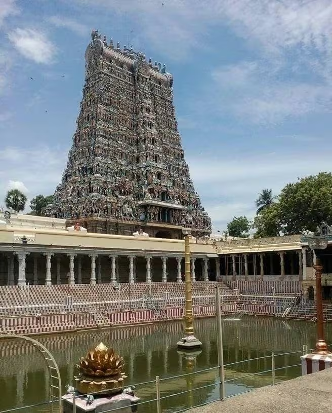
The Meenakshi-Sundareswarar complex in Madurai was the most extensive example. Successive rulers, queens, and ministers enlarged the complex, whose dimensions reached approximately 254 by 238 metres. Four towering gopurams, some reaching about 50 metres, define its monumental scale. The Nayakas followed the Dravidian architectural tradition, emphasizing gopurams, elaborate carving, and large columned mandapas.
The Azhagar Kovil and Tiruparankundram Murugan temple near Madurai were also expanded. At Srirangam, Nayaka patrons enlarged the Ranganathaswamy temple into a complex of seven concentric enclosures, each associated with towering gopurams. The work remained incomplete when the dynasty fell and continued afterward.
Royal architecture developed alongside temple construction. Tirumala Nayaka is associated with the Thirumalai Nayakar Mahal in Madurai. The surviving dance hall and audience hall combine indigenous elements with features associated with Bahmani architecture, including arches, cusps, geometric designs, plaster sculpture, and large columns. The palace expressed the political power of the court even though only two sections survive.
Nayaka coins also reflected a multilingual and multi-symbolic political culture. Coins could show the king, a bull, animals such as bears, elephants, and lions, or religious figures including Hanuman and Garuda. Inscriptions appeared in Tamil, Telugu, Kannada, and Nagari scripts.
The Madurai connection extended to Sri Lanka. Marital alliances between the Nayaka rulers of Madurai and the Kandyan court became increasingly important in the seventeenth and eighteenth centuries. In 1739, the Madurai-born brother-in-law of the last ethnically Sinhalese king of Kandy became Sri Vijaya Rajasinha, beginning the Kandy Nayak dynasty, which ruled until 1815.
Military Geography
The military organization of the kingdom rested on the relationship between the central army and the palaiyakkarars. The dalavai directed both civil and military affairs, while poligars maintained forces in their own palayams. The arrangement allowed the Nayakas to respond to threats across a large territory but also made military loyalty dependent on local interests.
Tirumala Nayaka increased the army to approximately 30,000 men. He used it against Mysore, Travancore, the Sethupathi of Ramnad, and the forces of Sriranga III. The palayam structure supplied additional local military resources, although poligars could revolt or act independently.
Madurai’s fortifications were rebuilt under Viswanatha. Tiruchirappalli became a key strategic capital because of its position in relation to Thanjavur and the Kaveri region. Dindigul was another important military location, associated with Mysorean invasion and the later rebellion of Bangaru Tirumalai. Vellore and Gingee belonged to the wider strategic theatre of the declining Vijayanagara Empire.
The Battle of Toppur in 1616 involved Madurai, Gingee, Thanjavur, Portuguese interests, and rival claimants to the Vijayanagara succession. Muttu Virappa’s support for Jagga Raya ended in defeat, forcing Madurai to pay a large tribute. Later, Tirumala allied with Golconda against Sriranga III. Golconda’s conquest of Vellore and the siege of Gingee demonstrated that the fall of Vijayanagara transformed the entire political map of southern India.
Mysore was the most persistent western military threat. It invaded Dindigul in 1620 but was repelled after the loyalty of the Pandyan vassals held. A larger invasion in 1625 was defeated by Tirumala’s forces, which then laid siege to Mysore. Another invasion in 1655 was stopped by Ragunatha Thevar of Ramnad while Tirumala was ill.
The coast required a different military strategy. Sethupathis protected the pilgrimage route to Rameswaram and contested Portuguese claims. The coastal defence system linked revenue collection, religious travel, local military authority, and overseas competition.
Political Geography
The Madurai Nayakas began as agents of Vijayanagara but gradually moved toward independence. Their relationship with the imperial court changed according to military circumstances. Early rulers provided troops and tribute, while later rulers withheld tribute as Vijayanagara weakened. Tirumala Nayaka’s cancellation of tribute was treated by Sriranga III as rebellion.
Relations with Thanjavur were particularly unstable. Thanjavur had received Chola Nadu when it was transferred from Viswanatha’s control. It later joined Madurai in an alliance against Sriranga III but defected before the conflict ended. During Chokkanatha’s reign, Madurai invaded Thanjavur after a revolt and placed his brother Muddu Alagiri on the throne. Alagiri soon declared independence, and the Marathas under Venkoji conquered the province in 1675.
Travancore alternated between tributary dependence and resistance. Its refusal to pay tribute led to campaigns under Viswanatha, Tirumala, and other rulers. Kandy was also connected through tribute, conquest, military intervention, and later marriage alliances.
Golconda and Bijapur became decisive powers in the later Vijayanagara crisis. Madurai’s alliance with Golconda contributed to the defeat of Sriranga III, but Golconda’s conquest of Vellore and its siege of Gingee also revealed that outside powers could reshape the territory around Madurai.
By the time of Rani Mangammal, Mughal power was approaching southern India. She judged it preferable to pay tribute rather than face invasion. She supported the Mughal capture of Gingee from Rajaram, who might otherwise have attacked Madurai and Thanjavur, and governed the fort as a Mughal vassal. Her policy shows how diplomacy and tribute could preserve the kingdom when direct military resistance was uncertain.
Legacy and Decline
Tirumala Nayaka was succeeded in 1659 by a son who ruled for only four months. Chokkanatha Nayaka then became ruler. His reign began with a rebellion by his army commander and chief minister, supported by Thanjavur. After suppressing the revolt, Chokkanatha invaded Thanjavur, but Madurai soon lost control when Muddu Alagiri declared independence. Mysore also took territory before Muttu Virappa III recaptured it.
After Muttu Virappa III died in 1689, his infant son inherited the throne, and Rani Mangammal governed as regent. Her recognition of Mughal authority was a pragmatic effort to protect Madurai from invasion. When Vijayaranga Chokkanatha reached maturity in 1704, he showed greater interest in scholarship than in government. Practical authority passed to a chief counsellor and army commander whose abuses weakened the state.
After Vijayaranga’s death in 1732, Queen Meenakshi adopted the son of Bangaru Tirumalai Nayaka. Bangaru Tirumalai rebelled against her. In 1734, the Nawab of Arcot sent an expedition to demand tribute and fealty from the southern kingdoms. Meenakshi sought assistance from Chanda Sahib, the Nawab’s son-in-law, and paid tribute to him.
Bangaru Tirumalai assembled a force of discontented polygars in the far south and captured Dindigul. At Ammayanayakkanur near Dindigul, Meenakshi and Chanda Sahib defeated his army. Bangaru Tirumalai fled to Sivaganga. After he was admitted into Tiruchirappalli fort, Chanda Sahib declared himself king and imprisoned Meenakshi in the palace. This ended the Madurai Nayaka dynasty in 1736. Tradition says that Meenakshi later poisoned herself in 1739, although the political end of Nayaka rule had already occurred.
The dynasty’s territorial configuration therefore lasted in changing forms for more than two centuries. Its most enduring legacy lies in the landscape it helped create: Madurai’s monumental temple complex, the palace of Tirumala Nayaka, expanded temples at Srirangam and elsewhere, fortified and irrigated centres, coastal institutions associated with the Sethupathis, and the long-lived political memory of the palayam and poligar system. The map of the Madurai Nayakas is consequently not only a record of changing boundaries. It is also a map of how military authority, pilgrimage, temple patronage, local chieftainship, and overseas commerce shaped southern Tamil Nadu.