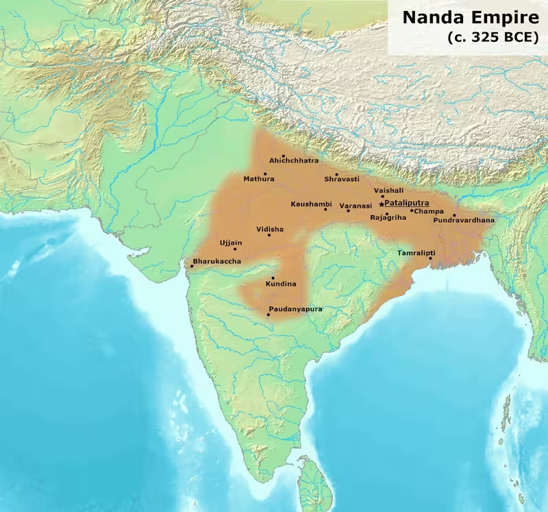
Nanda Empire at Its Greatest Extent, c. 344–322 BCE
Introduction
Alexander's soldiers reached the Beas River in 326 BCE and refused to continue eastward. Greek accounts attributed their decision partly to reports of a powerful kingdom beyond the river, ruled by a king known as Agrammes or Xandrames. Modern historians generally identify this ruler with the last Nanda king, usually called Dhana Nanda in Indian traditions. The map therefore captures more than a territorial outline: it shows the eastern power that shaped the limits of Alexander's Indian campaign.
At the centre of this political system stood Pataliputra, the capital of Magadha, near present-day Patna. From this eastern Gangetic base, the Nandas appear to have inherited and expanded the authority built by the Haryanka and Shaishunaga dynasties. Their strongest and most securely attested territory lay across Magadha and the Gangetic plain. Historical traditions also associate them with areas extending westward toward the Punjab frontier, south-westward into Avanti and the Narmada region, and eastward and southward toward Kalinga. The map distinguishes between the core of Nanda power and regions where control is inferred from indirect or later evidence.
The chronology of the dynasty is not settled. A commonly used reconstruction places Nanda rule around c. 344–322 BCE, while other traditions place its beginnings earlier and assign the dynasty reigns of very different lengths. The Nanda state ended when Chandragupta Maurya, supported by Chanakya in later accounts, overthrew the last Nanda ruler and established the Maurya Empire.
Historical Context
Magadha before the Nandas
The Nandas rose in Magadha, a kingdom in eastern India whose political centre lay near the junction of the Ganges and Son rivers. This location connected the capital to fertile agricultural districts, river transport, forest resources, elephants, and routes running across the northern plains. The Haryanka and Shaishunaga rulers had already expanded Magadhan authority before the Nandas came to power.
Buddhist traditions describe the Nandas as rulers who gained the throne through open conquest. Other traditions preserve stories of dynastic displacement and low-status origins. Greek and Jain accounts describe the founder through a barber-ancestry narrative, while the Puranas identify the founder as Mahapadma and connect him to the Shaishunaga line through a mother of Shudra status. Buddhist texts call the dynasty “of unknown lineage.” These accounts disagree, and the map does not treat any one origin story as a settled description of Nanda ancestry.
The Nandas' historical importance lies less in a secure genealogy than in the political consolidation associated with their rule. They appear to have transformed Magadha from a major eastern kingdom into a state claiming authority over a much wider zone. The Puranas describe Mahapadma as a ruler who destroyed or subordinated several Kshatriya lineages and established undisputed sovereignty. This language may express imperial ideology rather than the literal elimination of every local ruling family.
The Nanda kings
Indian traditions generally remember nine Nanda kings, but the names and succession lists vary. The Sri Lankan Buddhist Mahavamsa describes nine brothers ruling successively for twenty-two years. The Puranas also describe a founder followed by eight sons, although they name only a small number of these rulers. Greek writers, by contrast, usually mention only one Nanda ruler contemporary with Alexander.
This difference matters for the map's date. The political entity shown here is not a single campaign state created by one monarch. It represents a broad period during which the Nanda dynasty controlled or claimed authority over a large portion of northern and eastern India. The names Mahapadma Nanda and Dhana Nanda are useful markers for the beginning and end of the dynasty's expansion, but the exact sequence of territorial changes cannot be reconstructed with confidence.
Expansion and inherited territories
The Nandas built on earlier Magadhan expansion. The Shaishunagas are said in Puranic traditions to have subdued rulers in Avanti, while Magadhan authority had already reached regions such as Mithila and Kashi at earlier points. The Nandas may therefore have inherited a territory that already included important parts of the middle and eastern Gangetic world.
Later traditions attribute further conquests to Mahapadma. The territories named in these accounts include the Maithalas of Mithila, the Kasheyas around Kashi, the Ikshvakus of Kosala, the Panchalas, Shurasenas around Mathura, the Kurus, the Haihayas of the Narmada valley, the Kalingas, and the Ashmakas of the Godavari valley. These references are valuable for identifying the regions remembered as targets of Nanda expansion, but they do not prove that each area was governed in the same way or at the same time.
The map consequently uses different shades for the Magadhan core, probable or reported control, and disputed frontiers. A solid imperial boundary would imply a level of evidence that the surviving records do not provide.
Territorial Extent and Boundaries
The eastern Gangetic heartland
The most secure zone on the map is Magadha and the adjoining Gangetic plain. Pataliputra served as the capital, and Buddhist, Jain, Sanskrit, and Greek traditions connect the Nandas with this city. Greek accounts call the eastern power the kingdom of the Prasii and place its capital at Palibothra, generally identified with Pataliputra.
The Ganges and its tributaries formed the principal geographic framework of Nanda power. The river system supported agriculture, movement, and communication between the capital and the wider plain. The eastern region was also associated with the Gangaridai, a name traced to the Gangetic plain. Greek writers sometimes mention the Gangaridai and Prasii separately while describing them as under a common sovereign. This may indicate two political regions within one imperial system, a confederated arrangement, or differing Greek descriptions of the same broad power.
The map therefore treats the lower and middle Gangetic regions as part of the reported Nanda sphere, while avoiding the assumption that every local community was directly administered from Pataliputra.
The northern frontier
The Nanda realm bordered or included territories north of the Ganges, particularly Mithila and areas associated with the Maithalas. Mithila lay near the frontier of present-day northern Bihar and Nepal. Magadhan kings had already exerted authority there before the Nandas, and the Nandas may have subdued local chiefs who retained some independence.
The Himalayan foothills do not appear as a clearly fixed Nanda administrative boundary. The available traditions identify the Maithala region but do not define a continuous frontier line. The northern edge on a historical map should therefore be read as a zone of political influence rather than a surveyed border.
The western frontier
The western extent is connected most directly with Alexander's invasion. In 326 BCE, Alexander's army reached the Beas River after campaigning in the north-west. Greek writers placed the kingdom of the Gangaridai and Prasii beyond the Beas and described it as a formidable military power. This evidence suggests that the Nanda-ruled or Nanda-associated political world extended at least toward the western Gangetic plain, possibly as far as regions occupied by the Kurus and Panchalas.
The Panchalas occupied part of the Ganges valley north-west of Kosala. The Greek account of Alexander's expected eastern opponent has been interpreted as evidence that Nanda power reached the western Uttar Pradesh region. The Kurus, associated with the area around Kurukshetra, are also linked in Greek descriptions with the authority of the eastern king.
The map should not be read as proving direct Nanda occupation of the entire Punjab. The Nanda heartland lay far to the east, and Greek writers describe the eastern kingdom from the perspective of an invading army that did not enter it. The western shading therefore indicates a claimed or probable political horizon rather than a firmly established provincial boundary.
Kosala, Kashi, and Mathura
The Nanda relationship with Kosala is suggested by literary evidence. A passage in the Kathasaritsagara refers to a Nanda camp at Ayodhya, implying a military campaign in the Kosala region. The reference does not establish the date, duration, or administrative result of the campaign, but it supports the association of Nanda power with the middle Gangetic zone.
Kashi, centred on present-day Varanasi, had earlier been connected with Shaishunaga authority. The Nandas may have taken it from a successor of the Shaishunagas. The Shurasenas, whose centre lay around Mathura, are described in Greek accounts as subordinate to the king of the Prasii. This language may indicate tributary dependence, political submission, or a Greek interpretation of a wider imperial relationship.
Central India and Avanti
The southern and south-western extent of Nanda power is less certain. Jain tradition states that the Nandas followed Palaka, the son of the Avanti ruler Pradyota, and captured Ujjayini. Other historical reconstructions consider Nanda control of Avanti probable because the Shaishunagas are said to have subdued the region and the Mauryas later ruled in Central India.
The Haihayas occupied the Narmada valley and were associated with Mahishmati. Their territory is geographically plausible as part of a wider Central Indian sphere, but the evidence does not demonstrate the same degree of direct control attested for Magadha. The Vitihotras, linked with the Haihayas in Puranic traditions, present an additional chronological problem. Some accounts place their political end before the rise of the Nandas, while others make them contemporaries of the Shaishunagas.
For this reason, the map marks Avanti and the Narmada valley as probable or reported territory rather than an unquestioned part of a centrally administered Nanda empire.
Kalinga and the eastern coast
Kalinga occupied the coastal region corresponding broadly to present-day Odisha and parts of Andhra Pradesh. The strongest evidence connecting the Nandas with Kalinga comes from the later Hathigumpha inscription of Kharavela. It states that a Nanda king excavated a canal in Kalinga and removed a Jain image from the region.
The inscription refers to the canal as having been constructed a stated number of years earlier, but the expression is interpreted in different ways. It may mean three hundred years or one hundred and three years, and the chronological implications are therefore uncertain. Even so, the inscription preserves a memory of Nanda activity in Kalinga and is an important reason for showing the region within the Nanda sphere.
Kalinga's coastal position made it strategically and economically significant, but the available evidence does not describe a Nanda navy or a permanent coastal administration. The map indicates the region as a probable Nanda possession or dependency, not necessarily as a fully integrated province.
The southern frontier
The Nanda extension south of the Vindhya range remains debated. The Ashmakas occupied the Godavari valley in the Deccan. One theory connects the name of Nanded with “Nau Nand Dehra,” interpreted as the abode of the nine Nandas. This has been proposed as evidence of Nanda control, but it is not concrete proof.
Some inscriptions from Kuntala, including territory in present-day northern Karnataka, state that the region was ruled by the nine Nandas, Gupta rulers, and Mauryas. These inscriptions are very late, dating to around the twelfth century CE, and cannot securely establish the political geography of the fourth century BCE. The Mauryas did rule parts of southern India, but there is no satisfactory surviving account explaining whether that authority was inherited directly from the Nandas or acquired later.
The southern edge of the map therefore stops short of presenting the Deccan as securely Nanda-administered. The strongest imperial case remains north of the Vindhyas, with Kalinga as an important eastern coastal extension.
Administrative Structure
Little direct information survives about the Nanda administrative system. The Puranas call the Nanda king ekarat, or “single ruler,” suggesting an integrated monarchy. This description supports the image of a centralised state based on Pataliputra rather than a loose collection of unrelated kingdoms.
Greek evidence presents a more complicated picture. Arrian refers to aristocratic authority beyond the Beas, while other Greek accounts distinguish between the Gangaridai and the Prasii even as they place them under a common sovereign. These descriptions may indicate a layered political structure in which the capital exercised firm authority over the Magadhan core and accepted submission, tribute, or military support from frontier regions.
Buddhist legends concerning Chandragupta Maurya also imply a difference between the core and the periphery. They state that Chandragupta initially failed to defeat the Nandas by attacking their capital but later succeeded by conquering frontier areas first. Although this is a literary account rather than an administrative report, it suggests that the Nanda state may have combined strong control in the centre with more flexible authority at its margins.
No reliable provincial list survives. Territories such as Kosala, Panchala, Shurasena, Avanti, and Kalinga should not automatically be represented as provinces with uniform institutions. Some may have been directly governed; others may have retained local rulers under Nanda supremacy. The tradition that ministerial offices could be hereditary, preserved in Jain accounts about Shakatala and his sons, suggests the importance of elite families within the political system, but it does not provide a complete administrative structure.
Pataliputra was the central political and economic node. Its position near the Ganges and Son allowed the royal court to connect with the riverine plain. Greek identification of Palibothra with Pataliputra confirms that the city was recognised beyond India as the capital of a major eastern kingdom.
Infrastructure and Communications
The rivers of the Gangetic basin were the most important known communications system associated with the Nanda state. The Ganges and its tributaries connected Magadha with the eastern and central plain, while the Son gave Pataliputra access toward the south-west. River movement would have supported the movement of people, agricultural goods, armies, and officials, although the surviving accounts do not describe a formal transport department or postal network.
A canal in Kalinga is attributed to a Nanda king by the Hathigumpha inscription. Its purpose and exact location are not explained in the surviving evidence, but the reference demonstrates at least one major hydraulic work associated with Nanda rule. It also indicates an interest in infrastructure outside the immediate Magadhan heartland.
There is no securely documented Nanda road network comparable to later descriptions of imperial routes. The political geography nevertheless depended on corridors through the Gangetic plain, the approaches to Kosala and Panchala, routes toward Avanti, and the coastal zone of Kalinga. These should be understood as broad movement corridors rather than precisely mapped roads.
A Nanda-era currency or measurement reform may have supported communications and administration. The Kashika commentary on Panini mentions a Nanda measuring standard, while the existence of large punch-marked coin hoards has been connected with the dynasty. These developments could have helped the state assess taxes and move goods, although their exact date and administrative reach remain uncertain.
Economic Geography
Agriculture and riverine wealth
Magadha's power rested partly on its fertile alluvial environment. The Ganges and Son rivers supported agriculture and made Pataliputra a natural centre for collecting and redistributing resources. The adjoining forests supplied timber and elephants, both valuable for construction and warfare.
The Chota Nagpur Plateau, near the Magadhan heartland, was rich in minerals and raw materials. Earlier theories proposed that a Magadhan monopoly over iron ore drove imperial expansion, but this has been disputed. The region's wider mineral resources and access to raw materials nevertheless would have been significant assets.
The map's economic core is therefore not simply a political centre. It represents a landscape in which agriculture, river transport, forest products, elephants, and mineral resources reinforced one another.
Taxation and wealth
Ancient accounts consistently portray the Nandas as exceptionally wealthy. The Sri Lankan Buddhist tradition describes the last Nanda king as a treasure hoarder who accumulated vast riches. It also attributes taxes on a wide range of goods, including skins, gums, trees, and stones. These accounts may exaggerate royal wealth, but they preserve the memory of an extensive fiscal system.
The Nandas are associated with a new currency or measurement system. The phrase Nandopakramani manani in the Kashika has been interpreted as a Nanda-era standard of measurement. Punch-marked coins found at sites connected with Magadha, including a hoard from ancient Pataliputra, have also been linked with the period, though dating and attribution are not always certain.
A Tamil poem attributed to Mamulanar refers to the “untold wealth of the Nandas” and associates it with the Ganges. The verse has been interpreted either as describing wealth swept away by floods or treasure hidden in the river. Neither interpretation should be treated as a literal financial record, but the poem shows how Nanda wealth remained memorable beyond the Gangetic heartland.
Trade and commercial centres
Pataliputra was the principal known centre of Nanda economic geography. Its position on the Ganges–Son river system made it a meeting point for inland routes. Kashi, Kosala, Panchala, Mathura, Avanti, and Kalinga were connected to wider zones of production and exchange, although the available records do not provide a detailed list of Nanda markets or commodities.
The eastern coast and Kalinga may have provided access to maritime connections, but no specific Nanda port or naval organisation is securely documented. It is therefore safer to show Kalinga as a coastal economic region than to draw named maritime routes unsupported by the surviving evidence.
Cultural and Religious Geography
The Nanda realm occupied a region where Jainism, Buddhism, and Ajivikism were influential. The Greater Magadha area east of the Ganges–Yamuna confluence was associated with the rise of Jainism and Buddhism and with the wider Śramaṇa religious environment. Later interpretations differ over the relationship between the Nandas and Brahmanical traditions.
Some historians argue that the Nandas and Mauryas patronised religions associated with Greater Magadha, including Jainism and Ajivikism, and that the expansion of Magadhan power created opportunities for these traditions to spread westward. Other scholars have challenged a sharp cultural divide between eastern Magadha and the Brahmanical west, warning that the evidence does not justify a simple opposition between “Magadhan” and “Brahmanical” religious worlds.
Jain traditions preserve several stories about Nanda ministers. Kalpaka is described as a minister who promoted an aggressive expansionist policy. Shakatala's son Sthulabhadra is said to have refused a ministerial office and entered the Jain order, while his brother Shriyaka accepted the position. These narratives connect the Nanda court with Jain intellectual and monastic traditions, but they were recorded later and combine history with religious memory.
The literary traditions associated with Pataliputra also portray the city as a centre of learning. The Brihatkatha tradition places grammarians such as Panini, Katyayana, Vararuchi, and others in the Nanda period, although much of the account is regarded as unreliable folklore. It remains reasonable to present Pataliputra as a major intellectual and political centre, while avoiding a definitive list of scholars who certainly lived under Nanda patronage.
Military Geography
The army reported by Greek writers
The Nanda army is central to the map's historical significance. According to Curtius, the king identified with Dhana Nanda commanded 200,000 infantry, 20,000 cavalry, 3,000 elephants, and 2,000 four-horse chariots. Diodorus gives 4,000 elephants. Plutarch reports still larger numbers, including 200,000 infantry, 80,000 cavalry, 6,000 elephants, and 8,000 chariots.
These figures are probably exaggerated. Local populations may have had reasons to overstate the strength of the eastern kingdom in order to discourage Alexander's advance, and Greek writers often transmitted inflated numbers. Nevertheless, the agreement that the Nanda power possessed a very large army is historically significant.
The reported forces were not tested against Alexander. His soldiers mutinied at the Beas in 326 BCE, refusing to march farther east. Their decision followed years of campaigning and difficult fighting in north-western India. The prospect of facing an army several times the size of the Macedonian force contributed to the withdrawal.
Strategic geography
The Beas functioned as the practical limit of Alexander's campaign, not necessarily as the western boundary of the Nanda Empire. The river marked the point at which an invading army encountered the psychological and strategic weight of the eastern kingdom. Beyond it lay the Gangetic plain, the political world of the Prasii and Gangaridai, and ultimately Pataliputra.
The Nanda military system likely drew strength from the geography of Magadha. Rivers supported movement, fertile plains supplied provisions, forests provided elephants and timber, and Pataliputra's position offered protection at the junction of major waterways. Greek descriptions of a large elephant force are consistent with the importance of the eastern forests, although the exact numbers cannot be verified.
Literary accounts also refer to Nanda military operations in Kosala and to expansion into Kalinga and possibly Avanti. The tradition of Chandragupta's later campaigns against the Nandas describes a violent conflict, but the figures in the Milinda Panha—including enormous losses of elephants, horses, chariots, and infantry—are clearly exaggerated. They nevertheless preserve the memory of a major war rather than a peaceful transfer of power.
Political Geography
The Nandas inherited a political landscape containing older kingdoms, local lineages, and regional centres. Their relationship with these territories was not uniform.
Magadha was the core monarchy. Mithila, Kashi, Kosala, Panchala, and the Shurasena region appear in traditions that associate them with Magadhan or Nanda supremacy. The degree of direct rule is less certain. Local chiefs may have continued to exercise authority, particularly in frontier regions.
Avanti and Ujjayini represent the western and south-western political horizon. Jain accounts connect the Nandas with the fall or subordination of Avanti, while broader historical reasoning links Nanda authority with Central India. Kalinga represents an eastern coastal zone with a distinct political identity and a later inscriptional memory of Nanda intervention.
The Greek distinction between the Gangaridai and Prasii may indicate regional political organisation under a common ruler. It could also reflect the way foreign observers divided a large kingdom into separate geographic names. The map therefore presents these names as interpretive labels rather than as securely defined administrative units.
Relations with the north-west were shaped by Alexander's invasion. The Nanda state did not fight Alexander directly, but its reported strength affected the campaign's outcome. The Macedonian soldiers' refusal to proceed prevented a direct encounter and left the Nanda kingdom intact until the rise of Chandragupta Maurya.
Legacy and Decline
The Nanda dynasty was overthrown by Chandragupta Maurya, who founded the Maurya Empire. Later traditions connect Chanakya with Chandragupta's rise and describe the last Nanda king as unpopular because of low-status ancestry, excessive taxation, greed, and unrighteous conduct. Greek and Buddhist accounts similarly portray the final ruler as despised by his subjects.
These reports should be read critically. They were written or compiled after the dynasty's fall and may reflect the political needs of its successors. The Mauryan tradition had an obvious reason to portray the Nanda regime as oppressive and illegitimate. Even so, the repeated memory of heavy taxation and royal wealth suggests that the Nandas were associated with an unusually centralised and extractive state.
The transition from Nanda to Maurya rule did not erase the geographic foundations of Magadhan power. Pataliputra remained the capital of the Maurya Empire. The riverine core, agricultural base, access to forests and elephants, and connections across the Gangetic plain continued to support imperial expansion. The Mauryas may also have inherited territories or political claims established during the Nanda period, although the precise process by which southern and western regions came under Mauryan control is not fully recorded.
The map's most important historical message is therefore continuity as well as change. The Nandas created or consolidated a large Magadhan empire before the Mauryas, and their power was already recognised by Greek observers as a decisive factor in the politics of northern India. Yet the boundaries were not uniform lines. The secure centre lay in Magadha and the Gangetic plain; the western, southern, and coastal extensions rested on a mixture of literary traditions, indirect evidence, later inscriptions, and historical inference.
Reading the Map
The darkest area marks the Magadhan and Gangetic core centred on Pataliputra. A second zone extends toward Kosala, Kashi, Panchala, Mathura, and the western Gangetic plain, reflecting traditions of Nanda conquest or subordination. Central India and Avanti are shown more cautiously because the evidence for direct Nanda administration is less explicit. Kalinga appears as an important eastern region associated with Nanda hydraulic and political activity in the Hathigumpha inscription.
The western marker at the Beas is not a capital or battle site. It identifies the limit reached by Alexander's army and the point beyond which Greek accounts placed the formidable eastern kingdom. The southern shading should not be interpreted as proof that the Nandas controlled the whole Deccan. Late inscriptions and place-name theories suggest possible connections, but they do not securely establish a fourth-century BCE Nanda frontier south of the Vindhyas.
In this form, the map represents the Nanda Empire as a powerful but unevenly documented state: centralised around Pataliputra, dominant across the Gangetic heartland, influential across neighbouring kingdoms, and remembered as the eastern power whose military reputation helped bring Alexander's Indian campaign to an end.