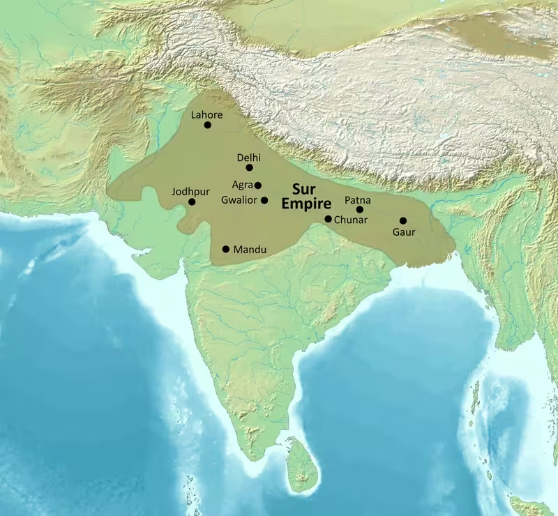
The Sur Empire on the Map, 1540–1545
Introduction
The decisive map moment for the Sur Empire came after the Battle of Kannauj in 1540, when Sher Khan defeated Humayun and captured Delhi. From this victory, an Afghan-origin dynasty briefly controlled much of the Mughal dominion across the Indo-Gangetic Plain. Its authority extended westward towards the Indus frontier and eastern Balochistan, while Sur power reached through Bengal towards the eastern regions described as modern-day Rakhine, Myanmar. Sasaram, in present-day Bihar, served as the imperial capital.
The Sur Empire lasted for roughly sixteen to eighteen years, depending on whether its beginning is dated from Sher Shah's effective rise in 1538 or his formal assumption of imperial power in 1540. The strongest phase belongs to Sher Shah Suri's reign, from 1540 until his death in 1545. This map therefore focuses on the territorial configuration created by his conquests, while also showing the contested frontiers and military corridors that continued to shape Sur rule under his successor, Islam Shah Suri.
The map is not simply a picture of a single, uniform block of territory. It brings together directly governed provinces, military commands, recently conquered regions, frontier zones, and areas where authority remained difficult to enforce. Bengal, the Punjab, Malwa, Rajasthan, Sindh, and the lands around the Ganges were connected by roads, forts, administrative divisions, and military garrisons, but their political conditions were not identical.
Historical Context
From Afghan service to imperial power
The Sur dynasty identified itself with Afghan lineage and traced its ancestry to Muhammad Sur, associated with the Ghurian house. The family entered Hindustan from Afghanistan and settled in the Punjab before entering the service of Afghan nobles. Sher Shah's early career developed within the political world of the Delhi Sultanate and the Afghan aristocracy. His rise took place during the weakening of Mughal control after Babur's conquest and during Humayun's difficulties in maintaining authority across northern India.
Sher Shah first directed his campaigns against the Bengal Sultanate. His pressure on Bengal led its ruler to seek assistance from Humayun. The Mughal emperor advanced towards Chunar in July 1537 and began a siege in November. Chunar resisted for more than six months before falling. While Humayun was occupied with the fort, Sher Shah invaded Bengal again and besieged Gauda. Afghan forces captured Gauda in April 1538. Rohtasgarh also came under Sher Shah's control in March 1538 and was used to place Afghan families and secure the wealth taken during the war.
Sher Shah offered Humayun terms that would have exchanged Bihar for control of Bengal. Humayun rejected the arrangement, partly because Bengal's resources were valuable and partly because he did not wish to leave the region in the hands of a hostile power. Humayun later occupied Gauda on 8 September 1538, but the city had been abandoned and its treasury removed. Monsoon conditions damaged his baggage and slowed his communications between Patna and Monghyr. His long stay at Gauda allowed Sher Shah to recover the initiative.
During Humayun's isolation in Bengal, Sher Shah moved through Bihar and Varanasi, recovered Chunar, and placed Jaunpur under siege. Afghan detachments reached as far as Kannauj. The Mughal army was therefore separated from its principal lines of communication. The resulting confrontation near the Karmanasa River became the Battle of Chausa. Sher Shah's forces surprised the Mughal army and routed it. Humayun escaped with his life, while more than 7,000 Mughal soldiers were reported killed.
Humayun returned to Agra and gathered another army. Sher Shah assembled a smaller force, and the two armies met at Kannauj in 1540. After Humayun crossed the Ganges and fighting began, Mughal nobles reportedly concealed their insignia or fled. The Mughal army was defeated, and Humayun retreated towards Sindh. Sher Khan was crowned for a second time on 17 May 1540 as Sher Shah and took the title Sultan Adil, meaning “Just King.” Delhi then came under his control.
Consolidation after 1540
Sher Shah did not treat the conquest of Delhi as the end of the war. Bengal required administrative reorganisation, the Punjab required military protection, and the western and central Indian states could potentially support a Mughal return. The Sur Empire therefore expanded through a combination of direct conquest, negotiated submission, garrisons, roads, and fortified positions.
In Bengal, Khijir Khan, the governor appointed under Sher Shah, revolted in March 1541. Sher Shah led the campaign personally, defeated him, and restored Bengal to Sur suzerainty. He divided Bengal into forty-seven smaller administrative units and placed them under shiqdars. Kazi Fajilot supervised the muqtars. This structure strengthened the position of Afghan officials and encouraged further Afghan settlement in the region.
Sher Shah next secured the Punjab. Lahore was captured in November 1540, and Afghan armies advanced towards the Khyber Pass. The empire did not extend beyond the Indus, because Sher Shah did not wish to absorb large numbers of Afghan groups whose independence could make them difficult to govern. Multan was taken in 1541, although it was later overrun by Baloch tribes. These developments led to another western campaign in 1543.
The Gakhars were a persistent challenge in the Punjab hills. They had maintained friendly relations with the Mughals since Babur's time and resisted Sher Shah's authority. Sher Shah attempted diplomacy with their chief, Sarang Khan, but the Gakhar response signalled defiance. Sher Shah then marched against them, devastated parts of the countryside, and ordered the construction of Rohtas Fort to control the region. He left 50,000 men in the Punjab while returning towards Bengal. The Gakhar conflict continued beyond Sher Shah's lifetime and remained unresolved during the later Sur period.
Campaigns in central and western India
In 1542 Sher Shah moved towards Gwalior and Malwa. He feared that Malwa might ally with Humayun, who was attempting to establish a base in Gujarat. Gwalior was subjugated under Afghan authority under the command of Shujaat Khan. The Afghan army then advanced towards Sarangpur. Qadir Khan, ruler of Malwa, found that his vassals would not support him and sought Sher Shah's mercy. Sher Shah treated him generously and granted him a jagir in Bengal, but Qadir Khan fled to Gujarat and later attempted to recover his lost territory.
Sher Shah consolidated Malwa before returning to Agra and received the submission of the ruler of Ranthambore. Shujaat Khan became governor of Malwa and defeated coalitions associated with Qadir Khan, despite numerical disadvantages. The appointment of a powerful governor and the distribution of military rewards show how Sur expansion depended on provincial commanders as well as the emperor's personal campaigns.
Raisen followed in 1543. Puran Mall had recovered the city after its earlier annexation by Bahadur Shah of Gujarat. Sher Shah offered Varanasi in exchange for Raisen, but Puran Mall refused. An Afghan army under Jalal Khan joined Sher Shah at Vidisha and advanced on Raisen. The siege lasted six months before artillery destroyed the city's defences and Puran Mall surrendered under negotiated terms.
The settlement promised safe passage for Puran Mall and his family, while Sher Shah agreed to withdraw two marches from the fort. The agreement collapsed after appeals from widows and survivors associated with Chanderi, who accused Puran Mall of severe oppression. Sher Shah ordered a forced march under Isa Khan Hajjab, and the retreating Rajput detachment was overtaken and destroyed.
Sher Shah's campaign against Marwar began in 1543. He marched with a force reported at 80,000 cavalry against Maldeo Rathore, who commanded approximately 50,000 men. The armies faced one another near Sammel in the pargana of Jaitaran, about ninety kilometres east of Jodhpur. After a month of skirmishing, food shortages threatened the Afghan army. Sher Shah used forged letters to create suspicion among Maldeo's commanders. Maldeo withdrew towards Jodhpur, leaving Jaita and Kumpa to fight with a smaller force.
The resulting Battle of Sammel, also called the Battle of Giri Sumel, ended in an Afghan victory, although Sher Shah's army suffered heavy casualties and several commanders died. Khawas Khan Marwat then occupied Marwar from Ajmer to Mount Abu, including Jodhpur. This conquest was short-lived in its fullest form. After Sher Shah's death, Maldeo recovered Jodhpur by July 1545 and restored the rest of his territories by 1546.
Territorial Extent and Boundaries
Western frontier
The western extent of Sur power reached towards eastern Balochistan and the Indus River. Multan was taken in 1541, but control there was not permanent. Baloch groups later overran the city and surrounding routes, prompting Sher Shah's 1543 campaign. Haibat Khan defeated or neutralised hostile forces and extended Sur authority through upper Sindh as far as Sehwan.
The Indus formed a practical limit to Sher Shah's westward expansion. Afghan armies reached the Khyber Pass, but the empire did not cross the Indus. This was a political decision as much as a geographical one. Sher Shah wanted to avoid incorporating Afghan groups whose independent traditions could create a new and difficult frontier problem.
The Punjab was therefore both a province and a military borderland. Lahore represented an important urban centre, while Rohtas Fort was built to monitor the Gakhars and guard against a Mughal return. The western frontier cannot be understood as a single fixed line: authority was stronger around garrisoned cities and roads and less secure in hill country and areas held by autonomous or semi-autonomous groups.
Northern frontier
The northern zone included Lahore, the Punjab, the approaches to the Khyber Pass, and the hill country associated with the Gakhars and the Kumaon Hills. Sher Shah's authority reached into the Punjab after Humayun withdrew towards Kabul. Kamran Mirza, Humayun's brother, did not risk confronting Sher Shah and retreated from the region.
Islam Shah later built a chain of fortresses north of Sialkot. These forts were intended both to deter a Mughal invasion and to keep the Gakhars and other hill communities under surveillance. The northern frontier thus remained a defensive system of forts, commanders, and garrisons rather than a quiet boundary.
Eastern frontier
Eastern India was a major centre of Sur power. Bengal had been the initial focus of Sher Shah's campaigns, and Gauda was the key city in the struggle against Humayun. Although Humayun briefly occupied Gauda in 1538, he found the city abandoned and its treasury removed. Sher Shah later restored Bengal to his authority and divided it into forty-seven administrative divisions.
The broad description of the Sur realm places its eastern reach as far as modern-day Rakhine, Myanmar. This does not mean that every eastern area was governed in the same manner or that the boundary was uniformly surveyed. The surviving political account distinguishes between a broad imperial sphere and the territories directly reorganised by Sur officials. Eastern India was nevertheless central to the empire's political economy. Eight of Sher Shah's sixteen silver mint cities were located between Chunar and Fathabad, demonstrating the concentration of monetary activity in the eastern and middle Ganges region.
Southern and central frontiers
Sur power extended southward from the Ganges plain into Malwa, Raisen, and parts of Rajasthan. Gwalior was subdued in 1542, followed by the advance towards Sarangpur and the submission of Qadir Khan. Raisen was conquered after a long siege in 1543. In Rajasthan, the victory at Sammel allowed Afghan forces to occupy territory from Ajmer to Mount Abu and to hold Jodhpur temporarily.
The southern frontier was not a single continuous border. Malwa had its own ruling tradition and political elite, while Marwar remained under a powerful Rajput ruler. Ranthambore submitted to Sher Shah, but the later recovery of Marwar by Maldeo shows how quickly control could weaken when imperial garrisons were removed or central leadership changed.
Core and contested territories
The core of the empire lay across the Indo-Gangetic Plain, where Delhi, Agra, Varanasi, Jaunpur, Bihar, Bengal, and the routes connecting them could be reached by armies and administrators. The Punjab, Sindh, Malwa, Marwar, and the hill country were more visibly military zones. Some rulers submitted after defeat, some received jagirs, and some continued to resist.
The map therefore differentiates between the imperial heartland and contested frontier regions. A Sur colour across a region indicates the assertion or exercise of authority, not necessarily identical levels of taxation, settlement, or administrative penetration.
Administrative Structure
Imperial centres
Sasaram served as the capital and remained closely associated with Sher Shah's identity. The city stood in Bihar, near the eastern theatre where he first built his power. Sher Shah's mausoleum was constructed there in the middle of an artificial lake. The monument rises to approximately 122 feet and was completed on 16 August 1545, three months after his death.
Delhi was captured after Humayun's defeat and represented the recovered imperial centre of northern India. Agra remained an important Mughal city and appeared in the political and military movements of the period. The Sur state therefore had a capital at Sasaram while also controlling older centres of imperial power in the upper Indo-Gangetic Plain.
Iqtas and military governors
The empire was divided into units known as iqtas. Some were governed by military commanders who combined administrative authority with control over troops. Haibat Khan governed the Punjab and commanded more than 30,000 men. Khawas Khan governed Rajasthan and assembled more than 20,000 men. Other commanders held titles such as hakim, faujdar, or momin.
These governors were not merely ceremonial officials. They possessed bodies of soldiers, distributed jagirs, maintained order, and conducted campaigns. Their strength also created a potential political problem. The later history of the Sur dynasty shows rebellions among amirs and military commanders, including Haibat Khan and Khawas Khan.
Sarkars and parganas
Iqtas were divided into districts called sarkars. Each sarkar had a shiqdar and a munsif. The shiqdar dealt with civil administration and could command between 200 and 300 soldiers for law and order. The munsif collected revenue and administered civil justice. Chief shiqdars could also handle criminal cases.
Sarkars were divided into two or three parganas. A pargana included a moderately sized town and its surrounding villages. It had a shiqdar, a munsif, a treasurer known as the fotdar, and a karkun who could write in Hindi and Persian. The pargana shiqdar operated under the sarkar shiqdar and assisted with the measurement of land, revenue collection, and local stability.
Villages retained a measure of autonomy. Village assemblies, or panchayats, dealt with local needs and punishments according to community custom. Sher Shah respected these institutions. Village chiefs acted as intermediaries between local communities and higher government, giving the administrative system a layered structure rather than replacing every local authority with imperial officials.
Bengal's reorganisation
Bengal received especially close attention because it had been the centre of Sher Shah's earliest major campaigns and possessed considerable resources. After defeating Khijir Khan's revolt in 1541, Sher Shah reorganised the province into forty-seven smaller divisions. Afghan officials became prominent, and Afghan settlement increased. Some settlers later founded the Muhammad Shahi dynasty, which ruled Bengal from 1553 to 1563, and the Karrani dynasty, which ruled from 1563 to 1576.
The Bengal arrangement demonstrates the difference between conquest and consolidation. Sher Shah had to return personally to the province after a governor rebelled. Administrative division, supervision, and settlement were intended to make the region more dependable after years of war.
Infrastructure and Communications
The Grand Trunk Road
Sher Shah rebuilt and modernised the Grand Trunk Road, described as a major artery running from modern-day Bangladesh towards Afghanistan. The road connected the eastern provinces with the imperial centres of northern India and the western frontier. Its importance was administrative as well as commercial: armies, officials, merchants, and postal riders could move along a more dependable corridor.
Caravanserais were built along the route to provide shelter for travellers. Mosques marked the road's religious and institutional landscape. Trees were planted on both sides to offer shade, and wells were dug, particularly along the western section. These improvements addressed the practical problems of travel across a large and environmentally varied empire.
Postal communications
Sher Shah established an organised postal system in which messages were carried by relays of horse riders. The arrangement supported a state whose governors and commanders were separated by long distances. It also helped the court monitor provincial conditions and coordinate military responses.
The need for such a system is clear from the campaigns of the period. Humayun's prolonged isolation at Gauda, the disturbances around Agra, the rebellion in Bengal, and the unrest in the Punjab all show how quickly communication could affect political outcomes. A relay system could not remove the difficulties created by monsoon weather or hostile territory, but it gave the Sur administration a more regular means of transmitting information.
Roads, forts, and military movement
Roads and forts worked together. The Lahore–Multan route was important enough for Sher Shah to plan a new road and to respond to raids by Fateh Khan Jat. Haibat Khan pursued the raider to a mud fort near Fatehpur, while the later campaign in upper Sindh secured the route as far as Sehwan.
Rohtas Fort watched the Gakhar frontier. Rohtasgarh protected a strategic position in Bihar and was used to secure Afghan families and war booty. Forts at Kalinjar, Raisen, Chunar, Gwalior, and other locations shaped the movement of armies and the political geography of the empire.
Maritime connections
The historical record described here does not establish a major Sur maritime programme or a distinct naval system. The empire's communications and trade infrastructure were overwhelmingly land-based, centred on roads, caravanserais, wells, fortified towns, and mounted postal relays.
Economic Geography
Coinage and mints
Sher Shah's monetary reforms formed one of the most enduring elements of his rule. The silver coin called the rupee was struck to a standard weight of 178 grains. The term had earlier been used generically for silver coinage, but under Sher Shah it became associated with a standard silver currency that preceded the modern rupee.
Gold coins called mohurs weighed 169 grains, while copper coins were known as paisa. Together, these coins formed a tri-metallic system of gold, silver, and copper. The system helped connect imperial revenue, military payments, market exchange, and long-distance commerce.
Sixteen silver mint cities are associated with Sher Shah's reign. Eight were located between Chunar and Fathabad, highlighting the economic significance of the middle and eastern regions. The placement of these mints also suggests that eastern India was not a peripheral possession but a central part of the Sur monetary system.
Trade and taxation
Sher Shah sought to encourage internal trade by abolishing taxes collected at provincial borders. Only two principal levies remained: one on goods brought into the country and another when goods were sold. Customs barriers between provinces were removed.
This policy complemented the Grand Trunk Road. Merchants could move between regions without facing repeated internal border charges, while caravanserais, wells, trees, and postal stations made the main land routes more usable. The reputation of Sher Shah's administration for protecting travellers also supported commercial movement. Accounts describe merchants travelling and sleeping in exposed areas without fear of bandits, because soldiers were tasked with policing routes and pursuing robbers.
The record identifies goods brought into the country and goods sold within the empire as taxable categories, but it does not provide a complete list of commodities. Bengal's wealth and resources are repeatedly emphasised, while the monetary evidence points to strong fiscal activity between Chunar and Fathabad. The map therefore marks trade corridors and mints rather than assigning unsupported commodity zones.
Agricultural and revenue regions
The administrative structure depended on land measurement and revenue collection. Munsifs worked at both sarkar and pargana levels, while local officials recorded and managed fiscal obligations. The Indo-Gangetic Plain provided the broad agricultural setting for this system, but the surviving account does not give a uniform revenue assessment for every province.
Bengal, Bihar, the upper Ganges region, the Punjab, Malwa, and Rajasthan differed in climate, terrain, and political organisation. The administrative network had to operate across these differences. The heavy emphasis on roads, wells, and local officials reflects the practical requirements of governing a large agrarian empire connected by long-distance routes.
Cultural and Religious Geography
A debated religious policy
Sher Shah's religious policy remains debated. One interpretation presents him as broadly tolerant towards Hindus. Another emphasises his personal devotion, regular prayer, and the language of religious struggle used in accounts of campaigns against Rajput rulers. The war against Puran Mall was described as a jihad in some narratives, while other accounts stress Sher Shah's comparatively accommodating treatment of Hindu subjects.
A balanced interpretation sees a ruler who upheld Islamic sovereignty while permitting Hindu communities and local institutions to continue. The administrative record indicates that panchayats were respected in village affairs and that Hindus settled disputes through their own assemblies. At the same time, criminal law applied across the empire, and Islamic officials such as qadis presided over courts.
Languages and administration
The administrative world of the Sur Empire was multilingual. Persian was used in official writing alongside Hindi. Karkuns in the parganas were expected to write in both languages. Sher Shah also valued Pashto as a sign of Afghan identity and offered higher salaries to soldiers who could speak it.
These linguistic patterns reflect the empire's political composition. Afghan commanders and settlers held prominent positions, Persian provided a language of administration, and Hindi remained important in local record-keeping and communication. The spread of Afghan officials in Bengal helped create new political communities that influenced the region after the Sur dynasty itself declined.
Monuments and architectural geography
Sher Shah's building programme extended across the empire. Rohtas Fort in present-day Pakistan was built to control the Gakhar frontier and is now recognised as a UNESCO World Heritage Site. At Rohtasgarh in Bihar, he constructed and maintained structures within an older fortified setting. In Patna, the Sher Shah Suri Masjid commemorates his reign.
Delhi's Purana Qila complex contains the Qila-i-Kuhna Mosque and the octagonal Sher Mandal. The latter later served as Humayun's library. These buildings place Sur architectural patronage within an older imperial landscape that was subsequently used by the Mughals.
The most monumental memorial is Sher Shah's tomb at Sasaram. Built in the middle of an artificial lake, the mausoleum is described as one of India's most impressive monuments. Its location in the capital rather than in Delhi or Agra reinforces Sasaram's role as the symbolic centre of Sher Shah's state.
Military Geography
The army and its organisation
Sher Shah's army relied heavily on cavalry. In 1540, it was reported to include more than 150,000 cavalrymen, 25,000 infantrymen, and over 5,000 war elephants. These figures come from historical accounts and should be treated as reported totals rather than precise modern censuses.
Infantry carried muskets, while cavalry formed the main striking force. Sher Shah divided the army into divisions under commanders and maintained strict discipline. Banjaras accompanied the army with provisions, reducing the danger of supply failure during long campaigns. The dagh system assigned identifying marks and roles to troops and helped officials detect false musters or concealed identities. Spies supported the enforcement of discipline.
Sher Shah recruited Afghans from across the empire and rewarded them with high office. Merit also played a role in advancement. The army was therefore both an instrument of conquest and a political network linking Afghan military households to the imperial state.
Chunar, Chausa, and Kannauj
The eastern theatre produced the victories that created the empire. Chunar controlled an important position on the Ganges route and resisted Humayun for more than six months. Gauda, the Bengal capital, fell to Sher Shah's Afghan forces in 1538. Rohtasgarh secured wealth and families away from the immediate theatre.
At Chausa, the Karmanasa River region became the setting for a surprise attack that destroyed Humayun's army. At Kannauj, the Mughal defeat became decisive. The map connects these sites to show how Sher Shah moved from control of eastern strongholds to the capture of Delhi.
The Punjab and Rohtas Fort
The Punjab campaign secured Lahore and Multan and pushed Afghan forces towards the Khyber Pass. The Gakhars remained a major problem because their power was rooted in difficult hill country and because they had longstanding ties with the Mughals.
Rohtas Fort was intended to contain this threat. Sher Shah left a large force in the Punjab after campaigning against Sarang Khan. The fort and its garrison were part of a wider strategy: hold the roads, watch the hills, prevent a Mughal return, and keep military pressure on communities that resisted central authority.
Malwa, Raisen, and Marwar
Gwalior was subdued before the advance into Malwa, preventing the Sur army from being flanked while it moved south. Sarangpur became a stage in the campaign, and Qadir Khan's submission brought Malwa temporarily into the Sur political system.
Raisen demonstrated the importance of artillery. Its defences held for six months but were destroyed by Sher Shah's guns. The siege also showed how political agreements could be overturned when competing claims of justice, religious duty, and military pressure intervened.
The Marwar campaign displayed a different kind of warfare. Sher Shah's army was large, but food shortages created a crisis. The forged letters that caused Maldeo to suspect his commanders were a psychological manoeuvre rather than a direct assault. Jaita and Kumpa then fought against overwhelming Afghan numbers at Sammel. The victory opened the route from Ajmer to Mount Abu and allowed the temporary occupation of Jodhpur.
Kalinjar and the end of Sher Shah's reign
After the conquest of Marwar, Sher Shah besieged Kalinjar in 1544. During the siege, a cannon's gunpowder exploded and mortally wounded him. He survived for two days and received news that the fort had fallen before dying on 22 May 1545. Accounts differ over his age, giving either fifty-nine or seventy-three.
His death illustrates the vulnerability of a conquest-based empire whose ruler personally directed campaigns across widely separated frontiers. Sher Shah had built roads, forts, revenue systems, and provincial commands, but the political balance among Afghan nobles remained fragile.
Political Geography
Relations with the Mughals
The Sur Empire was created through conflict with the Mughal Empire. Humayun's defeat at Chausa and Kannauj removed Mughal power from Delhi and the Indo-Gangetic heartland. Humayun fled towards Sindh, while his brother Kamran Mirza withdrew from the Punjab towards Kabul.
Sher Shah continued to prepare for a Mughal return. The Punjab garrisons, Rohtas Fort, and the chain of fortresses later built north of Sialkot all served defensive purposes. Yet Mughal claims did not disappear. They remained a constant factor in Sur strategy and contributed to the militarisation of the northern frontier.
Bengal and eastern power
Bengal was both a conquered kingdom and a foundation of Sur power. Sher Shah's campaigns began there, and the region remained important after the conquest. The revolt of Khijir Khan showed that the governor could not be left without supervision. Sher Shah's personal intervention and the subsequent division into forty-seven units strengthened imperial oversight.
Afghan settlement in Bengal produced political consequences beyond Sher Shah's reign. The Muhammad Shahi and Karrani dynasties later emerged from this Afghan presence, linking the Sur period to the subsequent history of Bengal.
Malwa, Gujarat, and Rajput states
Malwa was brought under Sur control because Sher Shah feared an alliance between Qadir Khan and Humayun's efforts in Gujarat. Qadir Khan's flight to Gujarat shows the continuing importance of neighbouring sultanates as possible bases for resistance.
Ranthambore submitted during Sher Shah's return to Agra. Marwar, however, remained a more difficult Rajput frontier. The temporary occupation of Jodhpur and the later recovery of the region by Maldeo demonstrate that submission and occupation did not necessarily equal permanent integration.
Afghan factions
The Sur political order depended heavily on Afghan commanders, but their military strength could also threaten the dynasty. After Sher Shah's death, his son Jalal Khan succeeded him as Islam Shah. Islam Shah faced rebellion from the amirs, including Kutb Khan, Haibat Khan, and Khawas Khan. Niazi nobles sought refuge with the Gakhars, and the conflict between the Afghan factions and Islam Shah continued.
Islam Shah defeated the Niazis at Ambala and Dhankot, but he could not decisively defeat the Gakhars or capture Haibat Khan for two years. In 1550, Niazi attempts to enter Kashmir were defeated by Mirza Haidar Dughlat at Sambla. These conflicts transformed the map from a unified imperial conquest into a field of rival Afghan military networks.
Legacy and Decline
Sher Shah's reign lasted only until 1545, but his administrative influence outlived the dynasty. The standard silver rupee, the tri-metallic coinage system, the organisation of iqtas, sarkars, and parganas, the road improvements, the postal relays, and the emphasis on disciplined military administration all became associated with his rule.
The Mughal restoration did not erase these developments. When the Mughals returned, especially under Akbar, they drew upon administrative practices associated with the Sur period. The Sur Empire therefore occupies an important place between the first Mughal conquest and the later consolidation of Mughal rule.
The dynasty's decline was accelerated by succession disputes, rebellion among Afghan nobles, and the difficulty of holding distant conquests together. Islam Shah ruled from 1545 to 1553, but the state became increasingly divided after his death. Rival Sur rulers competed for power, while Mughal forces prepared to reconquer the territories lost by Humayun.
One of the final episodes was the siege of Mankot in the summer of 1557. Sikandar Shah Suri had taken refuge there and resisted for six months with artillery and matchlocks. He surrendered to Mughal forces led by Bairam Khan on 25 July 1557. Although he was pardoned and entered Akbar's service, he soon lost favour. By this point, the political geography created by Sher Shah had been absorbed into the Mughal reconquest.
The map's central lesson is therefore one of rapid imperial formation and equally rapid political change. Between 1540 and 1545, Sher Shah transformed a successful Afghan military career into a state stretching across much of northern India. His power linked Bengal, Bihar, the Ganges plain, Delhi, the Punjab, Malwa, Sindh, and Rajasthan through campaigns, forts, officials, roads, and currency. Yet the same breadth made the empire dependent on strong leadership and reliable provincial loyalty. After his death, contested frontiers and rival commanders reopened the way for the Mughals.
The Sur Empire was short-lived, but its geographic and administrative legacy was not. Its roads continued to connect the subcontinent, its coinage supplied a model for later currency, its forts marked strategic frontiers, and its governing arrangements influenced the Mughal state that ultimately replaced it.