Overview
At an elevation of about 2,300 feet on the Deccan Plateau, Bidar developed into a fortified capital whose history stretches from the Mauryan period to the present day. The city stands in the far north of Karnataka, close to Maharashtra and Telangana, and its monuments preserve the political and cultural history of several Deccan powers. Bidar Fort, the Mahmud Gawan Madrasa, royal palaces, mosques, tomb complexes, and gateways form the most visible part of this heritage.
Bidar is particularly associated with the Bahmani Sultanate. Sultan Ahmad Shah I shifted the Bahmani capital from Gulbarga to Bidar in 1427, encouraging the rebuilding of the old fort and the construction of palaces, mosques, gardens, and educational institutions. The city remained a center of power under the Bahmanis and later the Barid Shahi rulers. Its position on a high plateau offered both defensibility and a climate that was considered more favorable than that of Gulbarga.
The historical city is also an example of how infrastructure shaped urban life. Its medieval karez system carried water through underground channels in terrain where drilling wells was difficult. Its craft traditions produced Bidriware, a dark metalwork decorated with silver inlay. Together, the fortifications, waterworks, monuments, and craft traditions explain why Bidar is often described as the “City of Whispering Monuments.”
Etymology and Names
The modern name Bidar is generally associated with the Kannada word bidiru, meaning bamboo. The city was also known as Bhadrakote. Other names belong partly to legend and tradition rather than to securely documented political history.
Some traditional accounts connect Bidar with the ancient kingdom of Vidarbha, which appears in early Hindu literary works including Malavikagnimitra, the Mahabharata, the Harivamsa, and several Puranas. The proposed connection rests largely on the similarity between the names Vidarbha and Bidar. This association was also mentioned in the writings of the historian Firishta.
Local tales further connect the place with Vidura, giving it the traditional name Viduranagara. Another story associates it with the meeting of Nala and Damayanti, described as the daughter of Raja Bhima, the king of Vidarbha. These traditions contribute to Bidar’s cultural memory, but they do not establish a continuous political identity between the ancient Vidarbha of literary references and the medieval city.
During Bahmani rule, Bidar was known as Muhammadabad. The name reflects the city’s transformation into a major Islamic royal center after the capital was moved there. In the modern period, Bidar became part of Mysore State in 1956 when Kannada-speaking areas were reorganized, and it is now in Karnataka.
Geography and Location
Bidar lies at approximately 17.9° north latitude and 77.5° east longitude. The present-day district covers about 5,448 square kilometres and extends between 17°35' and 18°25' north latitudes and 76°42' and 77°39' east longitudes. Its location places it near the meeting zone of Karnataka, Maharashtra, and Telangana.
Maharashtra lies to the west and north-west, with Latur, Nanded, and Osmanabad among the neighboring districts identified in the geographical record. Telangana lies to the east, including Nizamabad and Medak. Gulbarga district, now Kalaburagi, lies to the south. This position made Bidar part of the wider political and cultural world of the Deccan rather than an isolated northern Karnataka settlement.
The city occupies the edge of a plateau. This elevated setting helped shape the defensive character of Bidar Fort, whose citadel stands on the brink of the plateau. The elevation also influences the climate. Bidar is considered one of the coldest places in Karnataka by southern Indian standards. During December, winter night temperatures regularly hover around 11–12°C, while the mean daily maximum for the month is 27.3°C and the mean daily minimum is 13.4°C.
The seasonal pattern changes rapidly after the middle of February, when both daytime and nighttime temperatures rise. May is the hottest month, with a mean daily maximum of 38.8°C and a mean daily minimum of 25.9°C. The highest recorded temperature given for Bidar is 44°C on 8 May 1931. The lowest was 2.9°C on 5 January 1901, described as the lowest temperature ever recorded in Karnataka. During the cold wave of 2025–2026, Bidar recorded new November and December records and reached 5.3°C in January.
Geology, Soil, and Water
Bidar’s geology is central to understanding both its landscape and its historic water systems. The upper crust of the plateau consists of laterite, a relatively soft and porous rock with a limonitic surface. This layer varies considerably in depth, from about 100 feet to 500 feet. Beneath it lies trap, a much harder and less permeable rock.
During the monsoon, water filters downward through the laterite. The harder trappean layer arrests some of this movement, producing springs near the contact between the two geological strata. Over time, water erodes openings in the rock. Small orifices can widen into rifts, rifts into ravines, and ravines into valleys. The resulting landscape combines plateau edges, cliffs, and channels shaped by the movement of groundwater.
The Bidar karez systems follow geological fractures formed where laterite and basalt meet. These fractures create lineaments or spring-bearing zones. Medieval engineers used this natural structure to build underground channels that collected and distributed water.
The local soils are deep, well-drained, gravelly red clayey soils formed on laterite plateaus. They are more than 100 centimetres deep, slightly acidic to neutral, with a recorded pH of about 6.6. Their cation exchange capacity is low, and the gravel content is high near the surface, decreasing with depth. These conditions influenced both agriculture and settlement.
The karez was particularly valuable because the rocky ground made ordinary well construction difficult. The underground channels supplied drinking water to civilian settlements and to the garrison within Bidar Fort. Three systems are identified in the historical documentation: Naubad, Shukla Theerth, and Jamna Mori. Shukla Theerth is the longest, while Jamna Mori functioned mainly as a distribution system in the old city, with channels crossing beneath the streets.
Restoration work began in 2014 with desilting and excavation at Naubad. In 2015, twenty-seven vertical shafts connected with the karez were discovered. A seventh line of the system was uncovered in 2016 during excavation for a sewage line. The revival of these channels has been valuable for a city that faces water scarcity and has renewed attention to a form of engineering associated with the Bahmani period.
Ancient History
Bidar’s recorded history reaches back to the third century BCE, when the territory formed part of the Mauryan Empire. The available historical account does not provide a detailed description of the settlement during Mauryan rule, but the association places the region within the political sphere of one of the earliest large imperial formations in the subcontinent.
After the Mauryas, the territory passed through the hands of the Satavahanas, Kadambas, and Chalukyas of Badami. The Rashtrakutas later ruled the area, followed by the Chalukyas of Kalyana and the Kalachuris of Kalyani. These successive dynasties connected Bidar to the broader political history of the Deccan, where power shifted between regional courts and larger imperial formations.
For a shorter period after the Kalyani Chalukyas, the region was controlled by the Seunas of Devagiri and the Kakatiyas of Warangal. By the early fourteenth century, the political order of the Deccan was being reshaped by the expansion of the Delhi Sultanate.
The literary traditions surrounding Bidar add another layer to its early identity. References to Vidarbha in Sanskrit literature, stories of Vidura, and the tale of Nala and Damayanti have encouraged attempts to identify the city with older legendary places. These accounts are important as traditions associated with Bidar, but the securely recorded political history begins with its incorporation into successive Deccan empires.
Historical Timeline
The Delhi Sultanate first invaded the region under Alauddin Khilji. Later, Muhammad bin Tughluq brought the entire Deccan, including Bidar, under his control. The early fourteenth-century political setting is also associated with Prince Ulugh Khan, around 1322, when Bidar is described as possessing a small but strong fort.
In 1347, officers of the Delhi Sultanate stationed in the Deccan rebelled. Their revolt led to the establishment of the Bahmani dynasty at Gulbarga, also known as Hasanabad and now called Kalaburagi. Bidar was occupied by Ala-ud-Din Bahman Shah, the founder of the Bahmani dynasty.
The city’s decisive transformation came under Ahmad Shah I, who ruled from 1422 to 1486. In 1427 he moved the capital from Gulbarga to Bidar. The reasons given include the city’s better climate and its fertile, fruit-bearing land. The existing fort was rebuilt, and the new capital acquired royal residences, mosques, gardens, educational institutions, and stronger defenses.
Bidar remained under the Bahmani political tradition until the rise of the Barid Shahi dynasty. It was later conquered by the Bijapur Sultanate in 1619. The city then became part of the conflicts among the Deccan powers and the expanding Mughal Empire.
Aurangzeb visited Bidar during his Deccan campaigns. In 1635, the city was ravaged by Khan Dauran. In 1656, after a twenty-one-day war, Aurangzeb seized Bidar Fort from the Adil Shahis. Bidar was incorporated into the Mughal Empire for the second time and was made a subah, or imperial top-level province. The Telangana Subah was merged into it the following year.
The Mughal assault had a lasting effect on the Mahmud Gawan Madrasa. Gunpowder stored in rooms near the left minar exploded accidentally, destroying the tower and entrance and damaging approximately one-fourth of the building. Contemporary accounts describe Aurangzeb entering the city and ordering the khutba to be read in the name of his father, Shah Jahan, at a mosque associated with the Bahmani period.
In 1724, Bidar became part of the Asaf Jahi Kingdom of the Nizams. Mir Sa'id Muhammad Khan, the third son of Asaf Jah I, ruled from Bidar Fort between 1751 and 1762. His brother, Mir Nizam Ali Khan, later imprisoned him in the fort; Salabat Jang was killed there on 16 September 1763.
Bidar was connected to Hyderabad by rail in the early twentieth century. After independence, the reorganization of states in 1956 brought Kannada-speaking areas together in Mysore State, later renamed Karnataka. This placed Bidar within the modern state whose northern boundary and Deccan heritage it continues to represent.
Bahmani Period
The Bahmani period gave Bidar its most recognizable historic character. When Ahmad Shah I made the city his capital, the old fort was rebuilt and the urban landscape expanded. The city was not simply a royal enclosure. It included a citadel for the court and a separate fortified area for the wider population.
The Bahmani capital required institutions that could serve administration, religion, military organization, and education. Palaces, mosques, gardens, and a major madrasa were raised. The fort’s location along the plateau edge added a natural advantage to its walls and gateways. The karez network addressed the practical problem of supplying water to the court, residents, and garrison.
Mahmud Gawan, who became prime minister in 1466, was a major figure in Bidar’s history. His madrasa was planned as a multidisciplinary university and possessed a library said to contain around 3,000 valuable manuscripts. Its scale and design reflect the intellectual and political ambitions of the Bahmani capital.
Barid Shahi Period
Bidar remained under the Barid Shahi dynasty after the decline of unified Bahmani power. Several monuments within the fort were built or altered during this period. The Rangeen Mahal, for example, was rebuilt under the Barid Shahis and combines decorative features associated with Hindu and Muslim architectural traditions.
Barid Shahi influence is also visible in the tombs and palace interiors. The Tarkash Mahal is traditionally said to have been built for a Turkish wife of the sultan. Decorative remains suggest that Barid Shahi rulers built or expanded it while maintaining a large and diverse harem. Stucco decoration was used across its rooms.
The period therefore did not merely preserve the Bahmani city. It added new layers of palace decoration, tomb architecture, and courtly design to an already established capital.
Mughal and Nizam Periods
The Mughal capture of Bidar in 1656 ended Adil Shahi control and brought the city into the Mughal administrative system. The fort’s capture followed a sustained twenty-one-day campaign. The damaged Mahmud Gawan Madrasa became associated with the military occupation and the explosion of stored gunpowder.
Bidar’s incorporation into the Mughal Empire did not end its importance. It became a subah, and its fort continued to serve as a place of military and political authority. In 1724, the city passed into the Asaf Jahi dominions. The imprisonment and death of Salabat Jang in Bidar Fort in 1763 demonstrate that the fort retained a role in dynastic politics long after the Bahmani capital had disappeared.
Political and Military Significance
Bidar’s political importance rested on the combination of geography, fortification, water supply, and capital functions. The city was located on a high plateau with a fortified edge, and its citadel was separated from the wider urban settlement. This arrangement allowed the royal complex and civilian city to be defended as related but distinct spaces.
The fort’s plan is described as pentagonal, with five gateways serving the city. The main citadel was stronger than the fortification enclosing the broader settlement. Within it were royal palaces, halls, mosques, and administrative spaces. The city fortifications were topped with battlements, while the citadel provided the principal center of defense.
The Bahmani decision to move the capital from Gulbarga to Bidar gave these defenses a new political purpose. The city became the seat of a court that required large palaces, religious buildings, gardens, educational institutions, and facilities for soldiers. Its underground water system ensured that defense did not depend solely on exposed surface sources.
Bidar also became a contested point in the struggles between the Bahmani and Vijayanagara kingdoms. Later, the city was drawn into conflicts involving the Bijapur Sultanate and the Mughals. The twenty-one-day Mughal campaign of 1656 shows that Bidar Fort was a substantial military objective, not merely a ceremonial royal residence.
Religious and Cultural Importance
Bidar contains a wide range of Islamic religious and funerary monuments, including mosques, tomb complexes, and the Mahmud Gawan Madrasa. The density of tombs around the city is reflected in the nickname “City of Whispering Monuments.” According to the Karnataka archaeology department’s listing, about 30 of 61 monuments in and around Bidar are tombs.
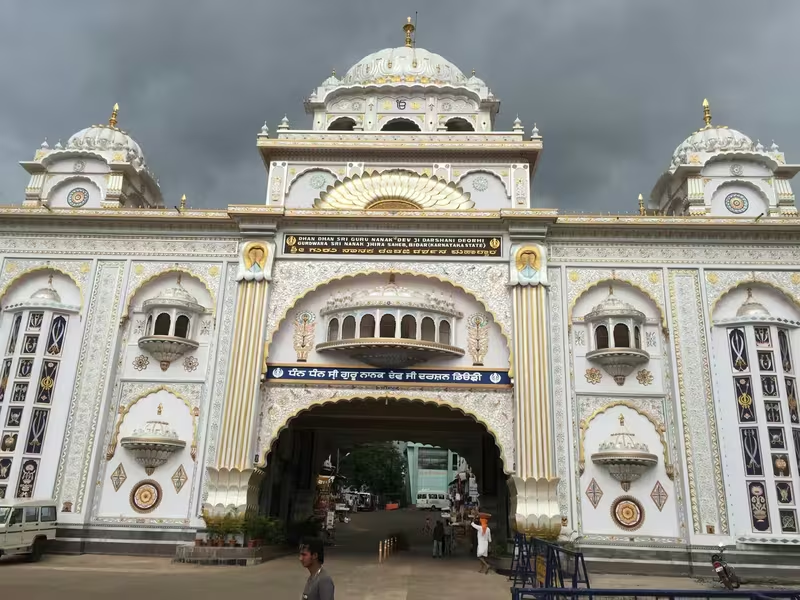
The city also has an important Sikh association. Gurudwara Nanak Jhira Sahib is considered one of the holiest Sikh pilgrimage places in India. Tradition holds that the first Sikh Guru, Shri Guru Nanak Dev Ji, visited the site during a famine in the region. This association gives Bidar a religious identity that extends beyond its Bahmani and Deccan Islamic heritage.
Bidar’s architecture is similarly plural in character. The Rangeen Mahal, for instance, is described as blending Hindu and Muslim architectural elements. Its decoration includes colored tiles, wood carving, mother-of-pearl inlay set into jet-black stone, floral designs, calligraphy, stone carving, and stucco work. These details show how courtly architecture in the Deccan brought together multiple artistic practices.
Economy and Craft
Bidar once supported a number of cottage industries, including cotton and oil-ginning mills. The city’s economy has changed, and relatively few industries now draw directly on local raw materials or traditional skills. The Kolar industrial area is the major industrial zone identified in the modern account.
The city’s most distinctive craft is Bidriware, a metalwork tradition known for intricate silver inlay against a dark surface. Bidriware has received a Geographical Indications registration and is regarded as unique to Bidar. Artisans from the city have produced objects that are now held in institutions including the Victoria and Albert Museum in London, the National Museum in New Delhi, and the Indian Museum in Kolkata.
The craft has also been used for ceremonial and international presentation. Bidriware and Bidri artisans were featured on the Karnataka tableau at the 2011 Republic Day Parade in New Delhi. Handcrafted Bidri objects were presented as mementos to dignitaries and guests at the 2010 Commonwealth Games. The craft was also selected for souvenirs at the World Economic Forum in Davos.
Despite this recognition, Bidri production faces serious difficulties. Rising material costs, especially the price of silver, and declining sales have reduced employment among hereditary artisans. The survival of Bidriware therefore depends not only on its reputation in museums and official events but also on sustaining the workshops and skills that produce it.
Monuments and Architecture
Bidar Fort
Bidar Fort is the central monument of the city’s historic landscape. Its present form is associated with Sultan Ahmad Shah Wali Bahmani, who rebuilt the fort after shifting the capital from Gulbarga. The fort stands on the edge of the plateau and contains the royal citadel, palaces, mosques, and other structures.
The wider city was planned alongside the citadel. The citadel complex housed royal buildings, while the southern side contained the fortified urban settlement. The fort’s pentagonal plan and five gateways structured access to the city. Engineers and architects from different countries were employed in its design and construction, reflecting the cosmopolitan character of the Bahmani court.
A museum within the fort displays old armor, sculptures, and ancient stones. The palace complex includes the Rangeen Mahal, Tarkash Mahal, Gagan Mahal, and Takht Mahal.
Rangeen Mahal
Near Gumbad Darwaza, the Rangeen Mahal is distinguished by its colored tiles and elaborate surface decoration. Its wood carving is described as both precious and unusual. Mother-of-pearl is inlaid into jet-black stone, while floral patterns and calligraphic text decorate the walls. Stone carving and stucco work add to its appearance.
The building was rebuilt during the Barid Shahi period. Its design is identified as a blend of Hindu and Muslim architectural forms. Rooms are also present in the basement, adding to the palace’s layered plan.
Tarkash Mahal
Tarkash Mahal is traditionally associated with a Turkish wife of the sultan. The surviving decorative work indicates that the Barid Shahi rulers built or expanded the palace. The building’s ornamented walls and stucco work reflect the courtly environment of a palace used by women from different national backgrounds.
Gagan Mahal
Gagan Mahal was originally constructed by the Bahmani kings, with alterations and additions under the Barid Shahis. It contains two courts. The outer court was used by male staff and guards, while the inner court included rooms on either side of a covered passage for guards. The main building served the sultan and his harem.
Takht Mahal
Takht Mahal, also called the Royal Palace, was built by Ahmad Shah. It served as a royal residence and was decorated with colored tiles and stone carvings, some of which remain. The palace included two royal pavilions with tall arches and a spacious hall leading to the sultan’s room.
Several Bahmani and Barid Shahi coronations were held there. From the royal pavilion behind the throne palace, it was possible to view the valley and lower land below the plateau.
Mahmud Gawan Madrasa
The Mahmud Gawan Madrasa was built in the late fifteenth century by Mahmud Gawan, the Bahmani prime minister. It was an imposing institution and a distinctive monument of the Bahmani period. Its plan and architectural style are described as unusual in India.
The madrasa functioned as a multidisciplinary university and housed a library of approximately 3,000 manuscripts. Its later history was marked by severe damage during Aurangzeb’s 1656 campaign. Gunpowder stored near the left minar exploded, destroying the tower and entrance and damaging around one-fourth of the building. The monument is protected by the Archaeological Survey of India.
Solah Khamba Mosque
The Solah Khamba Mosque, or Solah Sutoon Ki Masjid, was built by Qubil Sultani in 1423–1424. Its popular name refers to the sixteen pillars arranged at the front. The mosque is approximately 90 metres long and 24 metres wide.
It has columns, arches, and domes, and is described as one of the largest mosques in India. A large well lies behind its southern wall. The building is also popularly called the Zanana Masjid.
Chaubara
Chaubara is a cylindrical tower standing in the center of Bidar. It is approximately 22 metres high and faces in four directions. Its position gave observers a broad view of the plateau, making it useful as a watchtower.
A winding staircase of eight steps leads to the top, where a clock was placed. The clock could be viewed from all four directions. Nearby is the Jama Masjid, a large mosque without minarets.
Tombs and Other Structures
The Bahmani tombs at Ashtur, the Barid Shahi tombs, and the Chaukhandi of Hazrat Khalil Ullah extend Bidar’s historic landscape beyond the fort. Habshi Kot, on a hillock outside the city, contains the tombs of Abyssinian noblemen who served in the Bahmani and Barid Shahi courts.
Together, these structures explain the city’s reputation as a place of whispering monuments. The tombs, gateways, towers, mosques, palaces, and fortification walls do not form a single building complex; they create a broad historical landscape in and around the city.
Famous Personalities
Mahmud Gawan is the most prominent figure directly associated with Bidar’s Bahmani intellectual and architectural history. He became prime minister in 1466 and established the madrasa that bears his name. His institution combined higher learning, a substantial library, and monumental architecture.
Ahmad Shah I, also known as Ahmad Shah Wali Bahmani, transformed Bidar by moving the capital there in 1427. His reign is associated with the rebuilding of the fort and the construction of several important royal structures. Takht Mahal is attributed to him.
Aurangzeb is associated with the Mughal capture of Bidar in 1656. His campaign brought the fort into Mughal control and caused extensive damage to the Mahmud Gawan Madrasa when stored gunpowder exploded.
Salabat Jang, the third son of Asaf Jah I, ruled from Bidar Fort between 1751 and 1762. His imprisonment and death in the fort on 16 September 1763 connect the monument to the dynastic politics of the Nizam period.
The city’s cultural history also includes generations of Bidri artisans. Although the historical record does not identify all individual makers, their collective work has carried Bidar’s artistic name to major museums, national ceremonies, international forums, and private collections.
Decline, Conservation, and Revival
Bidar’s political centrality declined as the capital functions of the Bahmani kingdom ended and the region passed among the Barid Shahi, Bijapur, Mughal, and Asaf Jahi powers. Its monuments remained, but the city no longer served as the capital of a major independent Deccan sultanate.
Modern pressures have created new challenges. Bidar was placed on the World Monuments Watchlist in 2014. The concerns identified for the historic city include a lack of integrated conservation and maintenance, environmental pollution, and new development and roads encroaching on the historic fabric. Land-use regulations can also affect the economic livelihoods of residents. The conservation challenge is therefore not limited to repairing individual monuments; it involves managing the relationship between heritage, infrastructure, and the living city.
The watchlisting encouraged documentation, analysis, planning, and applied conservation. Its stated goal was to protect Bidar’s historic assets while supporting local residents and a sustainable tourism economy.
Water restoration offers a different kind of revival. Desilting and excavation of the Naubad karez began in 2014, leading to the discovery of vertical shafts and renewed attention to the underground network. Because Bidar continues to face water scarcity, the karez is not only an archaeological curiosity. It is also evidence of a historic solution to a persistent environmental problem.
Bidriware faces a parallel form of decline. The craft has achieved national and international recognition, but increasing silver prices and reduced sales have pushed many hereditary artisans out of production. Protecting Bidar’s heritage therefore requires attention to both monuments and living skills.
Modern City
Bidar remains the headquarters of Bidar district in Karnataka. In the 2011 census, the city had a population of 216,020, a literacy rate of 85.90 percent, and a sex ratio of 938 females per 1,000 males. Scheduled Castes accounted for 14.11 percent of the population and Scheduled Tribes for 4.73 percent.
Kannada was the first language of 52.23 percent of residents, followed by Urdu at 33.32 percent, Marathi at 5.54 percent, Hindi at 3.67 percent, and Telugu at 3.33 percent. These figures reflect Bidar’s location near linguistic boundaries and its long history within the multilingual Deccan.
The city is known for its comparatively cool climate, historical monuments, Bidriware, and Sikh pilgrimage. It has also served as a location for film shooting, attracting both Bollywood and the Kannada film industry. In 2009–10, Bidar was ranked twenty-second among India’s cleanest cities and fifth in Karnataka.
Bidar has educational institutions including Bidar Institute of Medical Sciences, Guru Nanak Dev Engineering College, Karnataka Veterinary, Animal and Fisheries Sciences University, and the Shaheen Group of Institutions. The city also contains a large industrial area known as Kolar industrial area.
In February 2025, Bidar was officially upgraded from a City Municipal Council to a City Corporation, although the final notification process was still underway. The Karnataka cabinet had initially approved the change in September 2024 and gave final approval in February 2025. The upgrade followed the incorporation of surrounding villages to meet a population threshold of more than three lakh people. A thirty-day period for objections was set before the corporation was to formally come into existence.
Transport and Access
Bidar is connected by road, rail, and air. State Highway 4 passes through the city, and the urban area is integrated with a four-lane road. Karnataka State Road Transport Corporation buses connect Bidar with Kalaburagi, Hyderabad, Latur, Udgir, Nanded, and Solapur. Volvo services connect it with Bengaluru, Hubli, Belagavi, Davangere, Mumbai, Mangaluru, and Pune.
The railway network provides links with Bengaluru, Hyderabad, Sainagar Shirdi, Parbhani Junction, Aurangabad, Latur, Nanded, Manmad, Mumbai, Visakhapatnam, Machilipatnam, Vijayawada, and Renigunta. The Gulbarga–Bidar rail link was completed and inaugurated by Prime Minister Narendra Modi. Bidar–Hyderabad inter-city services began in September 2012, followed by services to Yeshwantpur and Mumbai.
Bidar Airport, also known as Bidar Air Force Station, is a military airbase and domestic airport. Star Air operates a flight between Bidar and Bengaluru three days a week. The airbase is also associated with advanced jet training for prospective fighter pilots on BAe Hawk aircraft. Bidar is home to the country’s second-largest Indian Air Force training centre, according to the city’s historical and civic description.
Tourism and Heritage
Bidar’s tourism appeal comes from the concentration and variety of its heritage. The fort provides the main setting for royal palaces, the Solah Khamba Mosque, the museum, and the defensive architecture of the Bahmani capital. Nearby monuments expand the story to include tombs, madrasa architecture, watchtowers, mosques, and the residences of later Deccan courts.
The city’s heritage has international visibility through its 2014 World Monuments Watchlisting. It was selected from 741 proposals submitted from 166 countries; 67 sites from 41 countries were ultimately included. Two other Indian sites on the list were the house of Sheikh Salim Chisti at Fatehpur Sikri and Juna Mahal in Rajasthan.
A visit to Bidar also connects architecture with technology. The karez channels reveal how medieval engineers responded to the plateau’s geology. Bidriware demonstrates how a craft tradition became a regional identity. Gurudwara Nanak Jhira Sahib places the city within the geography of Sikh pilgrimage. The result is a heritage landscape made up not only of palaces and fort walls, but also of water, workshops, sacred memory, and a multilingual urban population.
Bidar’s continuing challenge is to make these elements work together. The survival of the historic city depends on conservation that protects monuments without severing them from residents, artisans, roads, water systems, and economic life. Its future as a heritage destination will therefore be shaped as much by planning and maintenance as by the fame of its fort.