Overview
On the southern fringes of modern Bhubaneswar, a broad quadrangular enclosure preserves the remains of Sisupalgarh, an early historic city of Kalinga. Its ramparts enclosed an area with a perimeter of about 4.8 kilometres, making it one of the largest and best-preserved early historic fortifications in India.
The settlement was occupied from around the 7th or 6th century BCE and may have continued well after the 4th century CE. Its scale is especially important because it shows that substantial urban communities existed in eastern India before, or at least before the full expansion of, the Mauryan Empire. The city is also identified by some historians with Kalinganagara associated with Kharavela and with Tosali associated with Ashoka, though these identifications are not presented as certain.
Sisupalgarh is now surrounded by modern development. The remains are nationally protected, yet encroachment and construction have placed important parts of the ancient enclosure under continuing pressure.
Etymology and Names
The site is known as Sisupalgarh or Sisupalagada. It has also been connected with two ancient place names: Kalinganagara and Tosali. Kalinganagara is associated with the Kalinga ruler Kharavela, while Tosali is linked with the Mauryan emperor Ashoka. These identifications help explain the site's historical importance, but the surviving archaeological record does not conclusively settle which ancient name belonged to the settlement.
Geography and Location
Sisupalgarh lies in Khurda District, near Bhubaneswar, the present capital of Odisha. In antiquity, the settlement stood within the historical region of Kalinga. Its defences formed a roughly quadrangular plan, oriented approximately 10 degrees clockwise from north, a layout comparable in this respect to the fortification at contemporary Jaugada.
The enclosure measured about 1,125 metres by 1,115 metres along the crest of the ramparts. Its defences are described as the highest known from this period in India. Archaeological observations suggest that the settlement may not have been densely built throughout. There may have been open areas inside the fortifications, including space for grazing.
Ancient History
Excavations and dating have pushed the origins of Sisupalgarh further back than early interpretations suggested. B. B. Lal, whose excavations began in 1948, concluded from architectural patterns and artefacts that the city flourished between the 3rd century BCE and the 4th century CE.
Later work by M. L. Smith and R. Mohanty proposed an earlier beginning, around the 5th century BCE, with the settlement probably surviving beyond the 4th century CE. Excavations conducted between 2005 and 2009 reached bedrock or natural soil in several parts of the settlement. Samples from five locations placed the earliest occupation around the 7th to 6th centuries BCE. The earliest radiocarbon date from inside the city was 804–669 BCE; a date from outside the enclosure was 793–555 BCE. The northern rampart was dated to 510–400 BCE.
These results indicate that the fortified settlement developed before the Mauryan Empire, although the exact sequence between early occupation, city planning, and the construction of the ramparts remains a subject of archaeological investigation.
Historical Timeline
Earliest occupation
Archaeological dating places the earliest occupation around the 7th to 6th centuries BCE.
Northern rampart
Dating places the northern rampart broadly between 510 and 400 BCE.
First excavation
B. B. Lal began the first excavations at Sisupalgarh.
New archaeological project
An American-Indian team began renewed investigation of the site.
Geophysical survey
Ground-penetrating radar revealed the probable position of the southern moat.
Mauryan and Early Historic Context
Sisupalgarh originated before the Mauryan Empire and may have remained an important centre during the period associated with Ashoka. Its proposed identification with Tosali connects it with Mauryan history, while its possible identification with Kalinganagara links it to Kharavela. The evidence does not establish a complete political history or identify every dynasty that controlled the city.
Later History
The settlement probably continued beyond the 4th century CE, but the available archaeological account does not provide a detailed narrative of its later rulers, decline, or abandonment. It is therefore safer to understand Sisupalgarh primarily through its fortifications, occupation layers, and architectural remains rather than through a continuous dynastic history.
Political and Military Significance
The size and construction of Sisupalgarh indicate organised labour, planning, and the ability to maintain a substantial defensive enclosure. Eight gateways are believed to have pierced the ancient fortifications. Today, only the northern gateway of the western wall survives in visible form, and even it is in ruins.
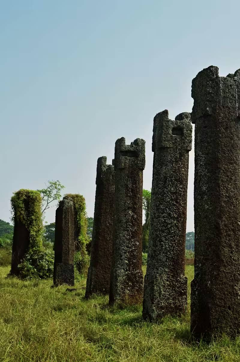
The gateway was once a large structure with guard houses and watchtowers. In 2005, researchers also recorded a disturbed and incomplete 19-column structure near the centre of the fortress. Two gates pierced each glacis of its quadrangular plan, adding to the impression of a carefully designed urban and defensive system.
Architecture and Archaeology
The Shola Khamba complex—literally “sixteen pillars”—is also called Rani Mahal. It may have formed part of a royal palace, although the precise function of the structure remains uncertain. An excavation in 2008 revealed additional pillars, but archaeologists could not determine what larger building they belonged to.
Researchers have combined geophysical survey, systematic surface collection, selected excavation, three-dimensional laser scanning, and the study of domestic and civic architecture. Together, these methods have helped reconstruct the city's scale and internal organisation without implying that the entire settlement has been excavated.
Population and Urban Life
Archaeologists have proposed that Sisupalgarh may have housed between 20,000 and 25,000 people. This would have made it a substantial urban centre; the comparison offered by researchers is with classical Athens, whose population is given as 10,000.
The estimate remains provisional. Only part of the city has been excavated, and the settlement may have included open land rather than continuous dense housing. Its population, therefore, is best treated as an archaeological reconstruction rather than a precise historical count.
Modern Status and Preservation
When Lal worked at Sisupalgarh, the area was described as wilderness. Much of the land within the ancient enclosure later passed into private possession, despite the site's status as a nationally protected monument under the Archaeological Survey of India.
Documentation in 2005 recorded considerable illegal building. Satellite images from 2002 onward showed house construction, particularly in the north-western quarter, accelerating after 2010. Encroachment has also extended into the southern city wall. The gateway and Shola Khamba complex are now threatened by construction only a short distance from the surviving remains.
Concerns have also been raised about the loss of excavated objects. Gold coins and terracotta pottery found during the first excavation in the late 1940s were subsequently lost. Sisupalgarh therefore represents both an exceptional archaeological archive and an urgent preservation challenge.