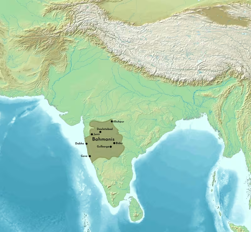
Bahmani Sultanate at Its Maximum Extent, 1466–1481
Introduction
The Bahmani Sultanate reached the greatest territorial extent associated with its history during the tenure of Mahmud Gawan, vizier and regent from 1466 until his execution in 1481. The map’s central subject is therefore not a single permanent boundary, but the late fifteenth-century expansion of a Deccan state whose frontiers were repeatedly tested by Vijayanagara, Malwa, Gujarat, and the Gajapati powers.
Founded in 1347 during the rebellion of Ismail Mukh and the Deccan amirs against Muhammad bin Tughlaq, the Bahmani Kingdom became the first independent Muslim sultanate of the Deccan. Its headquarters were initially at Hasanabad, generally identified with Gulbarga. Under Ahmad Shah I, the capital moved to Bidar, where the court developed a strongly Persianate political and cultural character. The sultanate survived for roughly 180 years, although effective authority weakened before its formal dissolution in 1527.
The map is best read as a representation of political reach during the period of Mahmud Gawan’s influence. It shows the Bahmani state as a major power of the Deccan Plateau, but it should not be interpreted as evidence of completely uniform administration across every region touched by Bahmani armies. Medieval frontiers were fluid, and the surviving historical record does not define all boundaries with equal precision.
Historical Context
From Delhi’s southern provinces to an independent kingdom
The Bahmani state emerged from the political crisis of the Tughlaq empire. Zafar Khan, also known as Hasan Gangu, had served as a governor and military commander under Muhammad bin Tughlaq. The movement of officials, soldiers, religious figures, and scholars from Delhi and northern India into the Deccan formed an important background to the creation of an independent sultanate.
On 3 August 1347, Ismail Mukh, who had been placed on the throne at Daulatabad by the rebel amirs, abdicated in favour of Zafar Khan. The rebels recognised Zafar Khan as the effective leader of the moment, and he was crowned Alauddin Bahman Shah Sultan. His new state established an independent political authority in the southern provinces of the former Delhi Sultanate.
The early capital was Hasanabad, identified with Gulbarga. The city became the centre of royal administration and coin production. Sufi legitimacy was also important. Chishti shaikhs supported the new ruler and bestowed on him a robe said to have been worn by the Prophet Muhammad. Such acts linked political sovereignty with spiritual authority and helped legitimise the transfer of Indo-Muslim rule from the Delhi region to the Deccan.
The origins of Bahman Shah himself remain debated. Abd-al-Malek Esami described him as born in Ghazni, while other historical interpretations have associated him with Afghan, Turkic, or Khorasani backgrounds. The medieval historian Ferishta considered a claimed descent from the Persian hero-king Bahram Gur implausible, suggesting that later poets had used the genealogy to flatter the dynasty. The map therefore represents a Deccan kingdom with northern and Persianate connections, but its founder’s precise ancestry should not be treated as settled.
The first phase of expansion
The Bahmani rulers quickly became involved in the political struggles of the southern Deccan. Their principal rival was the Vijayanagara Empire, while Warangal was another major power in the region. The two Bahmani–Vijayanagara states contested the Godavari basin, the Tungabhadra Doab, and Marathwada. These conflicts were not isolated incidents. Warfare recurred throughout the period, and the rivalry continued for as long as both kingdoms remained powerful.
Under Muhammad Shah I, Bahmani armies fought Vijayanagara and the southern Deccan kingdoms in particularly severe campaigns. Ferishta later wrote that the population of the Carnatic suffered such devastation that recovery took many generations. This description comes from a later chronicler and may reflect the conventions of medieval war writing, but it illustrates the remembered intensity of the conflict.
Muhammad Shah II’s reign was marked by relative peace in comparison with the wars of his predecessor. Administrative and military institutions established under Muhammad Shah I developed further during Muhammad Shah II’s rule. The contrast between these reigns demonstrates that the map’s territorial form was shaped not only by conquest, but also by periods of consolidation.
Firuz Shah and Ahmad Shah I
Taj ud-Din Firuz Shah became sultan in November 1397 after a succession crisis. He defeated the forces of Taghalchin, who had controlled the court and placed Shamsuddin on the throne as a puppet ruler. Firuz Shah fought Vijayanagara repeatedly. The Bahmani victories of 1398 and 1406 were followed by defeat in 1417. One victory resulted in Firuz Shah’s marriage to the daughter of Deva Raya, the Vijayanagara emperor.
Firuz Shah also expanded the composition of the nobility by granting Hindus high office. His reign saw the prominence of Sufis such as Gesudaraz, a Chishti saint who had migrated from Delhi to Daulatabad. The Dakhni dialect of Urdu gained wider use across the court, Sufi circles, and urban society. It became a lingua franca among Muslims of the Deccan and an expression of regional religious identity.
Ahmad Shah I Wali succeeded Firuz Shah and moved the capital to Bidar. Bidar’s importance in the map is therefore both political and architectural. Ahmad Shah built Bidar Fort and made the city the centre of the sultanate. He also led campaigns against Vijayanagara, Malwa, and Gujarat. His 1423 campaign against Vijayanagara included a siege of the imperial capital and ended in Bahmani expansion.
Ahmad Shah’s reign was also marked by campaigns against the remnants of Warangal. The movement of the court to Bidar placed the Bahmani administration closer to the central and eastern Deccan while retaining access to the plateau’s contested zones.
The later fifteenth century
Alauddin Ahmad II succeeded Ahmad Shah I in 1436. The Chand Minar at Daulatabad was constructed under his reign and commemorated his victory over Deva Raya II of Vijayanagara in 1443. This conflict was described as the last major war between the two powers during this phase, although military rivalry did not disappear.
The political elite changed during the fifteenth century. The original North Indian settlers and their descendants had initially occupied many senior positions. Later sultans recruited foreign immigrants from the west, including Persians, Afghans, and Turks. These newcomers were commonly described as Afaqis, while the established Deccani elite were known as Dakhanis.
The division was political, social, linguistic, and sectarian. Dakhanis generally spoke Dakhni, while Afaqis favoured Persian. Many Afaqis were Shi‘i or had Shi‘i affiliations, while the Dakhani elite were predominantly Sunni. These distinctions did not always determine political behaviour, but they contributed to factional competition at court.
Mahmud Gawan became the most influential figure of the late Bahmani period. He served as vizier and regent from 1466. A scholar, poet, administrator, and military leader, he directed campaigns against Malwa, Vijayanagara, and the Gajapatis. His campaigns are associated with the greatest extent of Bahmani authority, which is why this map uses 1466–1481 as its principal date range.
Gawan also reorganised the administrative structure. Earlier divisions numbered four; he increased them to eight in an effort to govern the enlarged kingdom more effectively. His reforms sought to reduce the power of provincial nobles and strengthen the central state. That objective brought him into conflict with factions at court.
In 1481, opponents produced a forged letter supposedly addressed to Purushottama Deva of Orissa. Muhammad Shah III ordered Mahmud Gawan’s execution. The sultan later regretted the decision, but the political damage was lasting. Gawan’s death removed the administrator most closely associated with late Bahmani expansion and reform.
Territorial Extent and Boundaries
The character of the frontier
The Bahmani Sultanate occupied the Deccan Plateau and extended through regions whose control varied according to military success, provincial authority, and the strength of neighbouring states. The map’s shaded territory should therefore be understood as a broad reconstruction of Bahmani political reach rather than as a modern-style border.
The core of the kingdom lay in the interior Deccan around Gulbarga and Bidar. From this central zone, Bahmani power was projected toward the Tungabhadra and Godavari basins, Marathwada, the eastern Deccan, and the territories linked to the campaigns of Mahmud Gawan.
Northern frontier
The northern political environment included the sultanates of Malwa and Gujarat. Ahmad Shah I campaigned against both powers, and Mahmud Gawan later led campaigns toward Malwa. These conflicts indicate that the Bahmani northern frontier was not merely an internal Deccan boundary. It was connected to the wider network of Indo-Muslim states extending across central and western India.
The northern edge of Bahmani influence should not be shown as a fixed line running across the plateau. Campaigns could extend beyond the regular administrative core without producing permanent annexation. The map marks this zone as a contested frontier wherever the political record associates Bahmani rulers with military action.
Southern frontier
The southern frontier was dominated by rivalry with Vijayanagara. The Tungabhadra Doab was one of the most persistent areas of contest. The riverine and agricultural landscape made the region strategically valuable, while its position between the two states ensured repeated military pressure.
Bahmani armies fought Vijayanagara throughout the dynasty’s history. Ahmad Shah I’s 1423 campaign reached the Vijayanagara capital, and Ahmad Shah II’s victory in 1443 was commemorated by the Chand Minar at Daulatabad. These campaigns demonstrate that Bahmani military geography was oriented toward the south as much as toward the north.
The map does not represent all southern territories as continuously administered by the Bahmani court. Rather, it distinguishes the central sultanate from zones repeatedly entered, occupied, or contested during wars with Vijayanagara.
Eastern frontier
The eastern Deccan and the territories associated with Warangal and the Gajapati rulers formed another important direction of expansion. Earlier Bahmani rulers fought Warangal, and Ahmad Shah I captured its remnants after campaigns marked by destruction and slaughter. Mahmud Gawan later led campaigns against the Gajapatis.
The eastern frontier connected the plateau to the political world of the Telugu-speaking regions and the successor states of the eastern Deccan. The historical record supplied for this map does not establish a continuous eastern boundary or identify every district under direct Bahmani administration. Accordingly, the map marks the area as an expansion and campaign zone rather than presenting every eastern limit as equally certain.
Western frontier
The western frontier faced the sultanate of Gujarat and the routes leading toward the western coast. Ahmad Shah I campaigned against Gujarat, and the Bahmani state’s western connections brought it into contact with broader Persianate networks. Nevertheless, the available record does not provide a detailed list of ports, coastal provinces, or maritime possessions.
The map’s western boundary should therefore be read conservatively. It identifies the Bahmani core in the interior Deccan and indicates military and political connections toward Gujarat without assigning unsupported coastal territories to the sultanate.
Direct rule, provincial authority, and contested zones
The Bahmani state was divided into provinces governed by tarafdars. The number of administrative divisions increased from four to eight under Mahmud Gawan. This reform reflects the challenge of governing a rapidly expanded territory in which provincial governors possessed substantial authority.
The later revolt of five provincial governors exposed the weakness of central control. Yusuf Adil Shah, Malik Ahmad Nizam Shah I, and Fathullah Imad-ul-Mulk declared independence in 1490, while Qasim Barid I followed in 1492. Their territories became the foundations of Bijapur, Ahmadnagar, Berar, and Bidar. Golkonda also became practically independent, and the five successor states came to be known collectively as the Deccan Sultanates.
The distinction between the royal heartland, provincial territory, campaign zones, and dependent or contested regions is essential when interpreting the maximum-extent map. The political colour indicates the reach of Bahmani power, but not an identical degree of administrative integration everywhere.
Administrative Structure
The sultan and the court
The Bahmani sultan stood at the head of the political order, but effective power depended on the court, the provincial governors, military commanders, and competing noble factions. The succession crises of the fourteenth and fifteenth centuries reveal the importance of powerful officials and military households.
Several rulers were unable to exercise full authority. Ghiyasuddin was blinded and imprisoned by Taghalchin, while Shamsuddin became a puppet king. During the minority of Nizam-Ud-Din Ahmad III and Muhammad Shah III Lashkari, Mahmud Gawan governed as regent until Muhammad Shah III reached maturity. After Gawan’s death, factional struggle increasingly weakened the monarchy.
The taraf system
The sultanate’s provinces were governed by tarafdars. Mahmud Gawan expanded the number of administrative divisions from four to eight. The measure was intended to distribute administrative responsibility and reduce the burden created by territorial expansion.
Provincial government was nevertheless a source of danger. Tarafdars possessed local military resources and could turn provincial office into the basis of independent rule. The revolts beginning in 1490 showed that the state’s administrative structure could become the mechanism through which the kingdom fragmented.
Deccani and Afaqi elites
The conflict between Dakhanis and Afaqis shaped the geography of power as much as the geography of territory. Dakhanis were the established Muslim elite descended from earlier northern immigrants, while Afaqis were more recent arrivals from western regions. Their differences included language, religious affiliation, patronage networks, and access to office.
Mahmud Gawan, himself associated with the Afaqis, attempted to reconcile the two groups. His reforms restricted the privileges of some nobles, intensifying opposition. The forged letter that led to his execution was part of this larger struggle. The crisis demonstrates that territorial expansion required political integration, and that administrative reform could provoke resistance among those whose authority depended on older arrangements.
Capitals and political centres
Gulbarga served as the first capital and remained a major Bahmani centre. Its fort, Jama Masjid, and Haft Gumbaz are among the architectural remains associated with the dynasty. The city was also the place where the early Bahmani coins were minted.
Bidar became the capital under Ahmad Shah I. Bidar Fort symbolised the relocation of royal power, while the Mahmud Gawan Madrasa represented the city’s educational and cultural importance. The two capitals should not be viewed as interchangeable points on a map: Gulbarga represents the first phase of Bahmani state formation, while Bidar reflects the later court and its Persianate institutional culture.
Daulatabad retained military and symbolic importance. It had been the site of the rebellion that produced the sultanate, and the Chand Minar was erected there during the fifteenth century. Golconda and Raichur were important strategic locations in the eastern and southern Deccan, although their precise administrative status changed over time.
Infrastructure and Communications
The surviving historical account gives more information about political centres, military campaigns, and administrative divisions than about roads, postal stations, or formal communication systems. It would therefore be misleading to draw a complete road or postal network on the map.
Movement across the Deccan
The Deccan Plateau provided the broad geographical setting for the kingdom. Armies, officials, merchants, religious figures, and scholars moved between northern India and the Deccan. The establishment of Bahmani rule encouraged further movement of Turkish or Indo-Turkish troops, explorers, saints, and scholars from Delhi and North India.
The capitals at Gulbarga and Bidar served as nodes of political communication. Daulatabad remained connected to the history of northern Deccan politics, while forts such as Bidar Fort and the strongholds of Golconda and Raichur anchored military movement.
Military communications
The administrative reform from four to eight divisions was itself a response to the problem of distance and communication. Dividing the kingdom into more manageable provinces could ease the transmission of orders and the mobilisation of troops, even though the available record does not describe a formal postal service.
Military campaigns followed the major political corridors of the Deccan: toward the Tungabhadra Doab and Vijayanagara in the south, toward the Godavari basin and eastern territories, and toward Malwa and Gujarat in the north and west. These directions are represented as campaign axes rather than as surveyed highways.
Maritime connections
The historical record identifies contact with overseas and western regions through the arrival of foreign nobles and the Persianate orientation of the court. It does not, however, provide sufficient information to map a Bahmani maritime network, a defined list of ports, or a naval system. The map consequently focuses on the plateau and its land-based political geography.
Economic Geography
Agriculture and the plateau
The Deccan Plateau supplied the territorial base of the Bahmani state. The Godavari basin, Tungabhadra Doab, and Marathwada were repeatedly contested, indicating the importance of their land and strategic position. The record does not provide quantified agricultural output or a detailed regional distribution of crops, so economic interpretation must remain general.
Control of agricultural regions supported the court, provincial administrations, and armies. Campaigns against Vijayanagara and other neighbours were therefore contests over productive territory as well as political prestige.
Trade and urban wealth
Afanasy Nikitin, a Russian merchant and traveller who passed through the Bahmani Sultanate, contrasted the great wealth of the nobility with the poverty of the peasantry and the frugality of Hindu communities. His observation provides a valuable glimpse of social inequality and elite consumption, although it does not establish precise trade volumes or commodity routes.
Gulbarga and Bidar were major political and cultural centres. Daulatabad, Golconda, and other fortified locations connected administration with military movement. The available record does not securely identify a complete list of markets or commodities, and no unsupported trade-route lines are included in the map.
Coinage and state authority
The early Bahmani state minted coins at Hasanabad, identified with Gulbarga. Coin production at the capital expressed political independence and distinguished the new sultanate from the Delhi Sultanate. It also demonstrates that the capital was an administrative and economic centre, not merely a royal residence.
Bidriware
Bidriware developed at Bidar during the fourteenth century under Bahmani rule. The craft used white brass that was blackened and inlaid with silver. Bidar remained its principal centre, and the name of the craft derives from the city.
Bidriware illustrates the relationship between political capitals and specialised cultural production. The craft was developed in an urban environment shaped by Bahmani patronage and the movement of artisans. It remains associated with Bidar and received a geographical indication registration on 3 January 2006.
Cultural and Religious Geography
Persianate court culture
The Bahmani dynasty patronised Persian language, culture, and literature from northern India and the Middle East. Members of the ruling house became proficient in Persian, and musicians travelled to the court from Lahore, Delhi, Persia, and Khorasan.
This cultural geography was not confined to the royal household. The movement of scholars, saints, soldiers, and administrators created links between the Deccan, northern India, Iran, Afghanistan, and other western regions. The court’s Persianate character coexisted with Dakhni language and local Deccani traditions.
Dakhni and regional identity
During Firuz Shah’s reign, Dakhni gained importance as a language of courtly and religious life. Gesudaraz and other Sufi figures were part of the environment in which regional Islamic identity developed. Dakhni’s spread across several social milieus shows that cultural integration did not depend solely on Persian.
The contrast between Dakhni-speaking Dakhanis and Persian-favouring Afaqis later became part of elite factional politics. Language was thus both a cultural marker and a political resource.
Sufi authority
Chishti Sufis helped legitimise the foundation of the Bahmani state. Their recognition of Bahman Shah gave spiritual support to the new political order. Sufis also remained visible in courtly and urban life, especially during Firuz Shah’s reign.
The political geography of the sultanate therefore included not only forts and capitals but also networks of religious authority. Daulatabad, Gulbarga, Bidar, and the routes connecting northern India with the Deccan were shaped by the movement of saints and scholars.
Shi‘i and Sunni affiliations
Several Bahmani nobles identified as Shi‘i or had strong Shi‘i inclinations, while many established Deccani nobles were Sunni. Ahmad Shah I converted to Shi‘ism after making Bidar his capital. Sectarian divisions became particularly violent during the reign of Alauddin Ahmad II, when a massacre of Persian Shi‘i sayyids was carried out by Sunni Dakhani nobles and their Abyssinian slaves.
The surviving narratives may exaggerate elements of these events, especially because some chroniclers were foreign immigrants connected with Safavid Persia. The episode nevertheless demonstrates the importance of religious affiliation within the political geography of the Bahmani court.
Architecture
Bahmani architecture combined local Deccan forms with influences from Persia, Turkey, and Arabia. Major works include:
- Gulbarga Fort
- Jama Masjid at Gulbarga
- Haft Gumbaz at Gulbarga
- Bidar Fort
- Mahmud Gawan Madrasa at Bidar
- Chand Minar at Daulatabad
- Bahmani tombs near the former capitals
Many buildings were destroyed or altered over time, but the surviving monuments preserve the geographical relationship between the dynasty’s two capitals and its major fortified centres.
The Bahmani tombs contain Arabic, Persian, and Urdu inscriptions. Some early constructions at Gulbarga display a Sasanian-style insignia of two open wings with a crescent and, occasionally, a circle. This design may have strengthened claims of Sasanian lineage, although the political meaning of individual examples should be treated carefully.
Military Geography
A kingdom shaped by war
The Bahmani Sultanate was perpetually at war with its neighbours. Its military geography centred on the southern rivalry with Vijayanagara, but also included campaigns against Warangal, Malwa, Gujarat, and the Gajapatis.
The Godavari basin, Tungabhadra Doab, and Marathwada were repeatedly fought over. The location of Raichur within the southern Deccan reflects the strategic importance of the region. Daulatabad, Bidar, Golconda, and other forts served as defensive and offensive positions.
Campaigns against Vijayanagara
The Bahmani–Vijayanagara rivalry lasted across the reigns of multiple rulers. Muhammad Shah I fought severe wars against the empire. Firuz Shah won campaigns in 1398 and 1406 but suffered defeat in 1417. Ahmad Shah I’s 1423 campaign included a siege of the Vijayanagara capital and ended with Bahmani expansion.
Alauddin Ahmad II’s victory over Deva Raya II in 1443 was commemorated through the Chand Minar at Daulatabad. Mahmud Gawan later led further campaigns against Vijayanagara. These wars shaped the political map of the southern Deccan and prevented the establishment of a stable frontier between the two states.
Campaigns toward Malwa, Gujarat, and the east
Ahmad Shah I campaigned against Malwa and Gujarat, while Mahmud Gawan also led campaigns in these directions. Gawan’s eastern campaigns included conflict with the Gajapatis. Earlier Bahmani rulers had fought Warangal, and Ahmad Shah I captured the remnants of that power.
The map uses campaign symbols in these regions because military activity did not necessarily create lasting direct rule. A campaign could secure tribute, alter a frontier, or strengthen a ruler’s reputation without permanently incorporating every place reached by an army.
Gunpowder and artillery
The Bahmani military was associated with early use of gunpowder weapons in the Indian subcontinent. The first recorded use described in the historical account occurred at the Battle of Adoni in 1368, when Muhammad Shah I used a train of artillery against Vijayanagara forces led by Harihara II.
This interpretation is debated. Iqtidar Alam Khan argued that a different translation of Ferishta may indicate that the Delhi Sultanate and non-Muslim Indian states already possessed gunpowder weapons, and that the Bahmanis may have acquired them from Delhi. Klaus Rötzer further suggested that early pyrotechnic weapons were primarily intended to frighten cavalry and elephants.
The use of cannons at the siege of Machal Fort in 1470 or January 1471 is described as the first known use of gunpowder in siege weaponry on the Deccan Plateau. The event marks an important transition in the military geography of forts, where artillery could be used directly against defensive works.
Captivity and military society
Wars between the Bahmanis and Vijayanagara involved the capture and enslavement of civilians and soldiers. Captives from Vijayanagara were converted to Islam and integrated into Bahmani society, where some began military careers. The army was therefore not only an institution of royal power; it was also a mechanism through which populations were displaced and incorporated.
The historical record does not provide reliable army totals for the period represented here. No numerical estimate is included on the map because the available evidence does not establish a secure figure.
Political Geography
Vijayanagara
Vijayanagara was the Bahmani Sultanate’s principal southern rival. The two states contested territory, resources, and political influence across the central and southern Deccan. Their conflicts were frequent, severe, and often connected with control of the Tungabhadra Doab and other strategic regions.
The relationship was not exclusively military. Firuz Shah’s marriage to a daughter of Deva Raya followed a Bahmani victory, demonstrating that warfare could lead to dynastic diplomacy. Yet marriage did not end the structural rivalry between the two states.
Malwa and Gujarat
The Bahmani state faced the sultanates of Malwa and Gujarat along its northern and western horizons. Ahmad Shah I and Mahmud Gawan campaigned against both. These campaigns placed the Deccan kingdom within the political system of the wider Indo-Islamic world rather than isolating it as a southern power.
The record does not define stable tributary arrangements with Malwa or Gujarat. The map therefore presents them as neighbouring and contested political zones, not as permanent Bahmani dependencies.
Warangal and the Gajapatis
Warangal was an important eastern rival during the earlier Bahmani period. Ahmad Shah I eventually captured the remnants of Warangal after campaigns involving destruction and slaughter. Mahmud Gawan later campaigned against the Gajapatis, whose territories lay in the eastern political world beyond the central Deccan.
These conflicts helped push Bahmani influence toward the eastern Deccan, while also exposing the limits of central authority over distant regions.
Delhi and northern India
The Bahmani state began as a rebellion within the southern provinces of the Delhi Sultanate. Its founding was therefore a direct consequence of the weakening of Tughlaq authority in the Deccan. After independence, the sultanate continued to receive people, ideas, and political influences from Delhi and northern India.
The movement of immigrants from northern India was particularly important during the foundation and early development of the kingdom. Later, western and Persian immigrants became increasingly prominent at court, contributing to the Afaqi–Dakhani conflict.
Legacy and Decline
The weakening of central power
Mahmud Gawan’s execution in 1481 marked a decisive weakening of the Bahmani state. Muhammad Shah III regretted the decision, but the factional conflict that had produced it continued. The monarchy became increasingly dependent on competing nobles and provincial governors.
Mahmood Shah Bahmani II succeeded Muhammad Shah III and was the last Bahmani ruler to possess real power. In 1490, Yusuf Adil Shah, Malik Ahmad Nizam Shah I, and Fathullah Imad-ul-Mulk asserted independence in Bijapur, Ahmadnagar, and Berar. Qasim Barid I followed in 1492 at Bidar. Golkonda became practically independent by 1518.
The five successor states—Ahmadnagar, Berar, Bidar, Bijapur, and Golkonda—became known collectively as the Deccan Sultanates. They preserved and transformed many political, cultural, architectural, and military traditions associated with Bahmani rule.
The final dissolution
After 1518, the last Bahmani sultans were puppet monarchs under the Barid Shahi prime ministers, who exercised effective authority. The sultanate formally dissolved in 1527, ending approximately 180 years of Bahmani rule over the Deccan.
The map’s 1466–1481 frame is therefore significant because it captures the kingdom near its maximum extent before the final phase of political fragmentation. It should not be confused with the boundaries of the later Deccan Sultanates, although many of those states emerged directly from Bahmani provincial structures.
Enduring influence
The Bahmani legacy survived in several forms:
- Political succession: The Deccan Sultanates emerged from the fragmentation of Bahmani provincial power.
- Urban centres: Gulbarga and Bidar remained central to the historical identity of the medieval Deccan.
- Architecture: Forts, mosques, tombs, madrasas, and minarets preserved a Persianate Indo-Islamic style later adopted by successor states.
- Language: Dakhni developed as a major regional language of Muslim society.
- Craft production: Bidriware continued the association between Bidar and metal inlay.
- Military change: Artillery and gunpowder weapons became increasingly important in Deccan warfare.
- Cultural circulation: Persian, Central Asian, northern Indian, and local Deccani influences met within the Bahmani court and its cities.
How to Read the Map
The map’s central shaded area represents the Bahmani Sultanate during the period associated with its maximum expansion under Mahmud Gawan. Gulbarga and Bidar should be read as successive capitals, while Daulatabad, Golconda, and Raichur represent important military or political locations.
The campaign zones extend beyond the most secure core because Bahmani armies operated across a wide area. The northern and western directions point toward Malwa and Gujarat; the eastern direction includes the Gajapati and former Warangal zones; and the southern frontier follows the long-running contest with Vijayanagara.
Because medieval sovereignty was layered and changeable, the map does not imply that every shaded region experienced identical administration. Some areas were directly governed through provincial divisions, while others were contested, temporarily occupied, or reached through campaigns. The greatest extent is consequently a historical interpretation of political power at its height, not a modern cadastral boundary.
Conclusion
The Bahmani Sultanate transformed the political geography of the Deccan after its foundation in 1347. From Gulbarga and later Bidar, its rulers built an independent kingdom that competed with Vijayanagara, confronted Malwa and Gujarat, fought Warangal and the Gajapatis, and supported a distinctive Indo-Persianate culture.
The period between 1466 and 1481, when Mahmud Gawan served as vizier and regent, represents the clearest moment of Bahmani territorial ambition. Gawan’s campaigns extended the sultanate’s reach, while his administrative reforms attempted to make the enlarged kingdom governable. His execution exposed the factional divisions that expansion had intensified.
By the sixteenth century, the Bahmani state had fragmented into the Deccan Sultanates. Yet the political centres, languages, monuments, administrative practices, and military traditions developed under Bahmani rule continued to shape the history of the Deccan long after the dynasty formally disappeared in 1527.