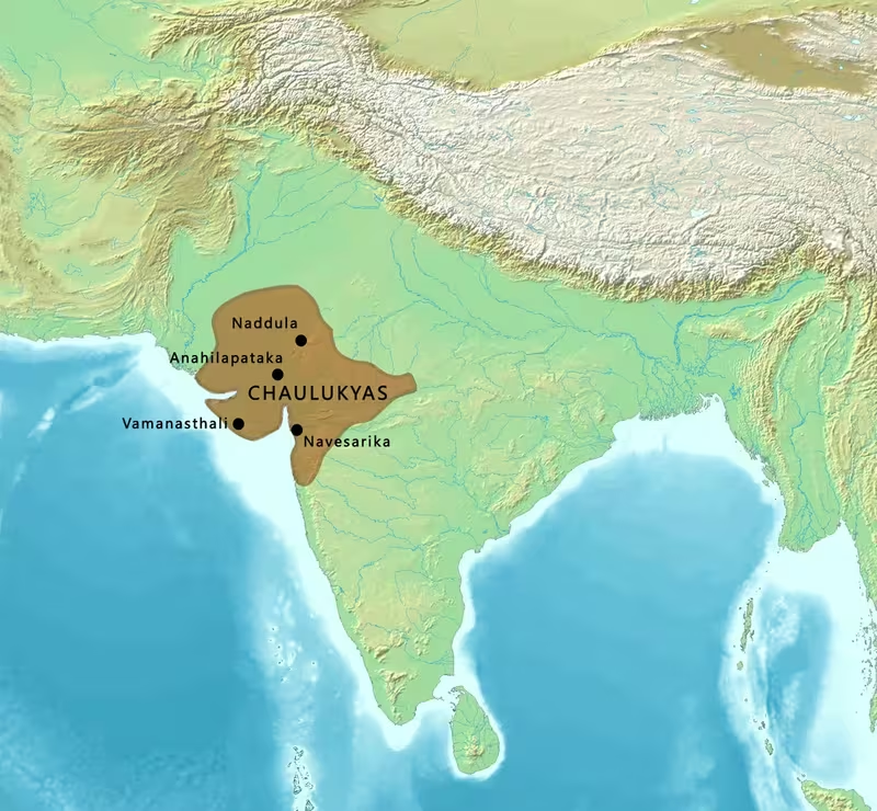
Chaulukya Kingdom at Its Zenith, c. 1143–1170 CE
Introduction
From Anahilapataka, the city identified with modern Patan, the Chaulukya rulers organised a kingdom that at its 12th-century height reached across Gujarat and into Rajasthan and Malwa. The map marks the period associated with Jayasimha Siddharaja and his successor Kumarapala, when Chaulukya authority extended from the north-western regions of Chittor and Jaisalmer to the Vindhyas and the Tapti River. It also shows a political landscape in which direct royal control existed alongside the authority of feudatories and subordinate dynasties.
The Chaulukyas, also called the Solankis in vernacular literature, ruled parts of present-day Gujarat and Rajasthan from approximately 940 to 1244 CE. Their greatest territorial expansion belonged to the 12th century, but their power was never static. Saurashtra, Lata, Malwa, the northern frontier, and the regions near the Aravalli zone repeatedly changed hands or became subjects of military contest. A boundary on this map should therefore be understood as an approximation of political influence rather than a modern fixed border.
This map focuses on the imperial phase beginning with Jayasimha Siddharaja's reign, conventionally dated c. 1092–1142 CE, and continuing through the period of Kumarapala. The chronology of Kumarapala's accession is transmitted inconsistently: one account gives 1043 CE, but the surrounding chronology places his accession after Jayasimha's death, generally around 1143 CE. The map uses the latter dating while recognising that medieval narrative traditions do not always agree.
Historical Context
The Chaulukya kingdom emerged during the weakening of the Gurjara-Pratihara and Rashtrakuta empires. Around 940 CE, Mularaja displaced Samantasimha, the last ruler of the Chavda dynasty, and established the political house that later became known as the Chaulukya or Solanki dynasty. Early expansion required repeated conflict with neighbouring powers, including the Chudasamas of Saurashtra, the Paramaras of Malwa and Arbuda, the Chahamanas of Shakambhari, and the Lata Chalukyas.
Mularaja's reign is associated in later accounts with campaigns against Graharipu of Saurashtra and the Lata Chalukya chief Barapa. His successor Chamundaraja ruled from approximately 996 CE. During this period, the Paramara king Sindhuraja appears to have invaded Lata, while the Chalukyas of Kalyani captured the region sometime before 1007 CE. Durlabharaja, who succeeded Chamundaraja around 1008 CE, briefly defeated the Lata ruler Kirtiraja or Kirtipala, although control soon returned to the Lata Chalukyas before the Paramara king Bhoja intervened.
The reign of Bhima I brought one of the most famous crises in Chaulukya history. In 1024–1025 CE, Mahmud, the Ghaznavid ruler, entered Chaulukya territory and raided the Somnath temple. Bhima withdrew to Kanthkot while the invasion proceeded, but restored Chaulukya authority after Mahmud's departure. The raid was a severe interruption, not the end of the kingdom. Bhima later subdued Paramara chiefs in Arbuda and defeated Krishnadeva, a ruler of the Paramara branch at Bhinmal. His conflicts with the Naddula Chahamanas show how the northern and north-eastern approaches remained contested.
Bhima's successor Karna ruled from approximately 1064 CE. His reign included warfare in Malwa, Lata, and the northern frontier. Karna recovered Lata from the Kalachuris around 1074 CE, although the region was lost again within a few years. The Naddula Chahamanas defeated him, and Jojalladeva reportedly occupied Anahilapataka while Karna was absent. Accounts of Karna's victories over Bhil and Koli groups are preserved in legendary chronicles and should be treated cautiously. These accounts also connect him with the foundation of Karnavati, although the identification of Karnavati with modern Ahmedabad is not certain.
Jayasimha Siddharaja
Jayasimha Siddharaja transformed the Chaulukya kingdom into a major regional power. His reign, generally dated c. 1092–1142 CE, saw campaigns against the Chudasama ruler Khangara or Navaghana in Saurashtra, the Chahamanas of Shakambhari, and the Paramaras of Malwa. The Naddula Chahamana ruler Asharaja, after losing his throne to Ratnapala, became Jayasimha's vassal before 1143 CE. Jayasimha also defeated the Shakambhari ruler Arnoraja, though the relationship later shifted from conflict to alliance.
Between 1135 and 1136 CE, Jayasimha annexed the Paramara kingdom of Malwa. The Paramara rulers Naravarman and Yashovarman were defeated, and Chaulukya power moved eastward. Jayasimha's forces reached the Chandela kingdom ruled by Madanavarman, although the outcome of that conflict was inconclusive: both sides claimed victory. The map therefore treats the eastern advance as an area of military reach rather than an uncontested permanent frontier.
Jayasimha's diplomacy was closely connected with his warfare. Arnoraja later married Jayasimha's daughter Kanchanadevi, and their son Someshvara was raised at the Chaulukya court. Someshvara's sons included Prithviraja III, better known as Prithviraj Chauhan, and Hariraja. These family connections linked the Chaulukya court with the Chahamana political world of Rajasthan.
Kumarapala
Kumarapala succeeded Jayasimha after spending part of his early life in exile. He returned to Anahilapataka and took the throne with the support of his brother-in-law Kanhadadeva. Arnoraja opposed his accession but was defeated. Kumarapala's rule consolidated much of the territory associated with the Chaulukya zenith.
After Jayasimha's death, the Paramara king Jayavarman I recovered Malwa, but an usurper named Ballala soon displaced him. Kumarapala then captured Malwa from Ballala. Ballala was killed in battle by Yashodhavala, a Paramara feudatory of Arbuda who served Kumarapala. Kumarapala also suppressed a rebellion by the Paramara chief Vikramasimha of Arbuda, while the Paramara branch at Kiradu continued to acknowledge his suzerainty.
Kumarapala extended his authority into northern Konkana through a campaign against Mallikarjuna, the Shilahara ruler. The campaign may have followed a Shilahara raid into southern Gujarat and ended with Mallikarjuna's death. In Saurashtra, Kumarapala relied on the Naddula Chahamana feudatory Alhana to suppress disturbances. These episodes show that the kingdom's apparent extent included several different forms of rule: direct possession, military occupation, subordinate dynasties, and locally governed feudatories.
Territorial Extent and Boundaries
The map's territorial outline follows the broadest extent attributed to Kumarapala's empire. In the north, Chaulukya authority reached toward Chittor and Jaisalmer. These regions lay within a politically complex zone where the Chaulukyas interacted with the Chahamanas, local chiefs, and other Rajput houses. The northern limit was therefore not a single fortified line. It represented overlapping claims, alliances, subordinate rulers, and periods of military success.
The western portion of the kingdom included Kachchha and Saurashtra. Saurashtra was both a strategic peninsula and a region of repeated conflict. Mularaja, Bhima I, Jayasimha, and Kumarapala all appear in campaigns or political interventions connected with the area. The Somnath temple, located on the Saurashtra coast, became particularly prominent in the history of Bhima I because of Mahmud's raid in 1024–1025 CE. The map marks Somnath as a religious and political centre, not as the capital of a separate Chaulukya province.
To the south, Kumarapala's territory extended to the Tapti River. The southern frontier included Lata, a historical region in southern Gujarat. Lata was often disputed. It came under the influence of the Lata Chalukyas, the Kalachuris, and the Chaulukyas of Gujarat at different times. Karna recovered the region from the Kalachuris around 1074 CE but lost it again within three years. This recurring instability explains why the map should show Lata as a zone of contest rather than a permanently fixed southern province.
The eastern frontier extended at least to Vidisha, also known as Bhilsa, in the Malwa region. Malwa was among the most important areas of Chaulukya expansion. Jayasimha conquered it from the Paramaras in the 1130s, and Kumarapala later captured it from Ballala. Yet Paramara rulers repeatedly attempted to recover the region. The Vindhyas formed a broad geographical reference for the southern and south-eastern extent, but the historical record does not establish a uniform natural boundary throughout the kingdom.
The map distinguishes core territory from extended or contested zones because political control was layered. Anahilapataka and the principal territories of Gujarat formed the central base. Malwa, Arbuda, Lata, Saurashtra, and parts of Rajasthan were connected to the kingdom through different combinations of conquest, tribute, feudatory allegiance, and military intervention. The Chaulukya state was not a compact territorial nation in the modern sense.
Administrative Structure
Anahilapataka was the political centre of the dynasty. The city, identified with modern Patan, served as the royal capital and the point from which campaigns and alliances were organised. When foreign armies or regional rivals threatened the kingdom, control of Anahilapataka carried enormous political significance. The Ghurid general Qutb al-Din Aibak captured the capital in 1197 CE, and the event inflicted a major defeat on the Chaulukyas even though their generals later recovered the city.
The administrative structure combined royal authority with the autonomy of subordinate houses. The Naddula and Jalor Chahamanas appear among the most important feudatories. Paramara chiefs of Arbuda and Kiradu also served within the Chaulukya political system. Their status could change over time. A ruler might be defeated and displaced, restored as a subordinate, or allowed to govern while acknowledging Chaulukya suzerainty.
The relationship between the central court and feudatories was particularly visible in military affairs. Kumarapala requested Alhana of Naddula to suppress disturbances in Saurashtra. At the battle of Kasahrada in 1178 CE, the Chaulukya army included Kelhanadeva of Naddula, Kirtipala of Jalor, and Dharavarsha of Arbuda. Such participation indicates that the kingdom's military capacity depended partly on the ability of the central ruler to mobilise subordinate chiefs.
The evidence does not provide a complete administrative list of provinces, nor does it define a uniform system of taxation, governors, or official districts across the entire empire. The map therefore avoids presenting every region as an identically governed unit. Direct royal control was strongest around the capital and the principal Chaulukya territories, while frontier areas were often administered through allied or subordinate rulers.
Infrastructure and Communications
The surviving historical record used here does not provide a detailed account of Chaulukya roads, postal stations, bridges, or a formal communications network. It is therefore not possible to reconstruct a complete infrastructure map without moving beyond the documented evidence. Nevertheless, the military and political history shows that the kingdom was connected by routes capable of carrying armies between Anahilapataka, Saurashtra, Lata, Malwa, Arbuda, and the northern frontier.
The movement of armies between Gujarat and Malwa required communication across the plains and upland approaches of western India. Jayasimha's eastward campaigns, Kumarapala's operations in Malwa, and the movement of feudatory forces to Kasahrada all reveal the importance of these corridors. The map marks such connections as campaign relationships rather than as precisely surveyed roads.
The capital's repeated recovery after invasion also suggests the importance of political communication between the court and regional commanders. After the Ghurid attack on Anahilapataka in 1197 CE, Lavanaprasada and Shridhara forced the invaders to retreat, and the capital returned to Chaulukya control by 1201 CE. This response depended on the mobilisation of forces outside the immediate capital region, although the record does not specify the communication mechanisms used.
The kingdom possessed access to the Arabian Sea through Gujarat and Saurashtra, but the available account does not describe a Chaulukya navy, port administration, or maritime trade system in detail. Nor does it identify particular commercial roads or shipping routes. The map therefore shows the coastal position of the kingdom geographically while avoiding unsupported claims about naval organisation or specific trade corridors.
Economic Geography
The economic geography of the Chaulukya kingdom can be inferred only in broad terms from its territorial and political history. Gujarat, Saurashtra, Kachchha, Lata, and the Malwa region formed a connected western Indian zone with different landscapes and strategic resources. The kingdom's reach from the north-western drylands to the Tapti and from the coast to the Vindhyas gave it access to varied agricultural and commercial environments.
Lata was especially significant because it occupied southern Gujarat and repeatedly attracted the attention of the Lata Chalukyas, Kalachuris, and Chaulukyas of Gujarat. Its changing political status reflects its strategic value. Saurashtra likewise mattered not only for its religious centres but also because control of the peninsula strengthened the Chaulukya position along the western coast.
The record does not specify the principal commodities traded from these regions, nor does it provide population estimates, revenue figures, or market statistics. No securely documented list of major Chaulukya ports is established in the material considered here. It is therefore safer to describe Gujarat and Saurashtra as economically important coastal zones without assigning them a fully documented commercial network.
Agriculture would have supported the kingdom's core areas, but the surviving account does not identify particular crops or irrigation systems. The location of the capital in Gujarat, the possession of Saurashtra and Kachchha, and the extension toward Malwa indicate that the dynasty governed a geographically diverse economic base. The political importance of feudatories also suggests that local elites played a major role in collecting resources and raising forces, although the precise mechanisms are not detailed.
Cultural and Religious Geography
The Chaulukya period is strongly associated with the development of Māru-Gurjara architecture, also called the Chaulukya style. This form of north Indian temple architecture originated in Gujarat and Rajasthan between the 11th and 13th centuries. It later became especially prominent in Jain temples and spread beyond the region, including through Jain communities elsewhere in India and in diaspora settings.
Religious patronage crossed sectarian boundaries. Mularaja is said to have built the Mulavasatika temple for Digambara Jains and the Mulanatha-Jinadeva temple for Svetambara Jains. The earliest Dilwara Temples and the Modhera Sun Temple were constructed during the reign of Bhima I. Popular tradition also attributes the construction of the Queen's step-well to Bhima's queen Udayamati.
Kumarapala became a patron of Jainism at some point during his life. Later Jain accounts portray him as the last great royal patron of the faith, although such accounts naturally emphasise his relationship with Jain institutions. The Chaulukya rulers also endowed mosques in an effort to maintain good relations with Muslim traders. This indicates that religious geography was connected with political and commercial relationships rather than being limited to a single royal tradition.
Somnath remained one of the most important religious locations associated with the kingdom. Mahmud's raid in 1024–1025 CE made the temple central to later historical memory, but the Chaulukya kingdom recovered after the attack. The map treats Somnath as a major religious landmark within the wider Saurashtra landscape.
The dynasty used the self-designation “Chaulukya” in most surviving records, while “Solanki” or “Solankhi” became a vernacular form. The court also employed titles such as “Gurjararāja” and “Gurjareśvara.” These titles referred to rule over territory known as Gurjara in the period; they do not by themselves prove that the dynasty belonged to a foreign-origin Gurjara tribe. The Agnikula origin story linking the Chaulukyas with fire-born Rajput clans appears in later tradition and was not claimed by the Chaulukya rulers themselves.
Military Geography
The Chaulukya military landscape was defined by several recurring fronts. Saurashtra was contested by the Chudasamas and later stabilised through Chaulukya intervention. Lata formed a southern corridor where the dynasty confronted Lata Chalukyas and Kalachuris. Malwa was the principal eastern theatre, contested with the Paramaras. The northern and north-eastern approaches brought the Chaulukyas into conflict with the Chahamanas of Naddula and Shakambhari.
Bhima I's response to Mahmud's raid demonstrates the vulnerability of the kingdom's western religious centres and the resilience of its political core. Bhima withdrew to Kanthkot during the invasion and restored Chaulukya authority after Mahmud's departure. His later conflicts with Paramara chiefs and the Naddula Chahamanas show that the kingdom's recovery involved renewed campaigning across the frontier.
Karna faced pressure from several directions. The Paramaras and Chahamanas challenged him in Malwa and the north, while the Kalachuris disputed Lata. His occupation of Lata was temporary, and the occupation of Anahilapataka by Jojalladeva exposed the vulnerability of the capital when the king was away.
Jayasimha's campaigns produced the broadest expansion. His conquest of Malwa gave the Chaulukyas influence over a major plateau region, while his campaigns against the Chudasamas and Chahamanas strengthened the western and northern fronts. The inconclusive conflict with the Chandelas shows that expansion toward central India had limits.
Kumarapala relied heavily on feudatory military power. At Kasahrada or Kayadara in 1178 CE, Muhammad of Ghor was defeated by a large army that included the Naddula Chahamana ruler Kelhanadeva, the Jalor Chahamana ruler Kirtipala, and the Arbuda Paramara ruler Dharavarsha. The victory illustrates how the Chaulukya political system could combine forces from several subordinate houses against an external invasion.
The map does not specify troop numbers or a standard army organisation because those details are not securely established in the historical record considered here. It instead highlights the network of feudatory participation that made Chaulukya defence possible.
Political Geography
The Chaulukya kingdom was surrounded by rival dynasties and connected to them through warfare, marriage, vassalage, and shifting alliances. The Paramaras were both major rivals and occasional subordinate allies. Their branches in Arbuda and Kiradu acknowledged Chaulukya authority at different points, while the Paramara rulers of Malwa repeatedly challenged Chaulukya control.
The Chahamanas occupied an equally complex position. Jayasimha defeated Arnoraja of Shakambhari, but later accepted him as an ally and arranged his marriage to Kanchanadevi. The Naddula Chahamanas served as Chaulukya feudatories, although they also fought the Chaulukya rulers at various moments. The Jalor Chahamanas likewise appear as subordinate allies during the 1178 CE campaign.
Relations with the Chudasamas of Saurashtra were more directly competitive. Jayasimha defeated Khangara or Navaghana, while Kumarapala later relied on Alhana of Naddula to suppress disturbances in the region. The political history of Saurashtra therefore combined conquest with continued local resistance.
The Chaulukyas also confronted powers farther away. The Shilahara ruler of northern Konkana was defeated during Kumarapala's southern campaign. The Yadavas later invaded the southern part of the kingdom, while the Ghurids attacked from the north-west. These pressures became increasingly damaging after Kumarapala's death.
The marriage network linking the Chaulukyas and Chahamanas had long-term significance. Someshvara, grandson of Jayasimha through Kanchanadevi, was raised at the Chaulukya court. His sons included Prithviraja III and Hariraja, connecting the Chaulukya political world with the later history of northern India.
Legacy and Decline
Kumarapala's territorial configuration did not survive unchanged after his death. Ajayapala retained his territories but ruled only briefly. His young sons Mularaja II and Bhima II succeeded him in turn, and the minority of Bhima II created opportunities for provincial governors and feudatories to seek independence.
The Ghurid invasion of 1178 CE was defeated at Kasahrada, but later Ghurid pressure proved more serious. During the 1190s, the Ghurids defeated Prithviraja III and other major rulers of northern India. On 4 February 1197 CE, Qutb al-Din Aibak invaded Anahilapataka and inflicted a massive defeat on the Chaulukyas. Lavanaprasada and Shridhara later forced the Ghurids to retreat, and the capital returned to Chaulukya control by 1201 CE.
The kingdom also faced attacks from the Paramaras and Yadavas. Subhatavarman of Malwa invaded Lata around 1204 CE and may have sacked Anahilapataka. Chaulukya generals again forced him to withdraw. Between 1205 and 1210 CE, Bhima's relative Jayantasimha or Jayasimha usurped the throne. In the early 1210s, Subhatavarman's successor Arjunavarman defeated Jayantasimha and later formed a matrimonial alliance with him. Bhima eventually recovered the throne between 1223 and 1226 CE.
The northern feudatories of Marwar rebelled during Yadava invasions, while the Guhilas of Medapata, associated with Mewar, declared independence sometime between 1207 and 1227 CE. Lavanaprasada and Viradhavala, originally powerful Vaghela feudatories, defended the kingdom against the Yadavas and subdued some rebellions. By the end of Bhima's reign they assumed titles such as Maharajadhiraja and Maharaja, although they continued nominally to acknowledge Bhima and his successor Tribhuvanapala.
After Tribhuvanapala, Lavanaprasada and Viradhavala seized the throne and established the Vaghela dynasty in the 1240s. The political map of the Chaulukya kingdom thus gave way to a new ruling house that had risen from within the existing system of generals and feudatories.
The dynasty's cultural legacy endured beyond its political fall. Māru-Gurjara architecture continued to shape temple building, especially in Jain communities. Later princely states whose rulers called themselves Solanki claimed descent from the Chaulukyas, including the rulers of Lunavada State. These later claims demonstrate the continuing prestige of the dynasty, even though genealogical descent was not always independently verifiable.
The map's central lesson is therefore not simply the size of the Chaulukya kingdom. It shows how power in medieval western India was assembled through a capital, regional conquests, feudatory alliances, dynastic marriages, religious patronage, and repeated military recovery. Its greatest extent was real, but it was also negotiated and contested. The boundaries around Malwa, Lata, Saurashtra, Rajasthan, and the Vindhyan approaches were zones of political movement rather than permanent lines on the ground.