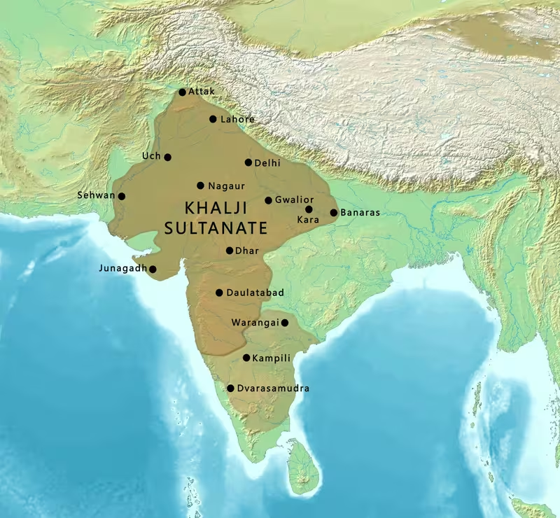
Khalji Sultanate at Its Greatest Extent, c. 1311
Introduction
The Khalji map is defined by a striking contrast: a Delhi-centred sultanate in the north and a rapidly expanding sphere of military power stretching through Gujarat, Rajputana, Malwa, the Deccan, and parts of southern India. The dynasty ruled from 1290 to 1320, but its most extensive territorial phase came during the twenty-year reign of Alauddin Khalji, whose generals carried campaigns far beyond the political heartland around Delhi.
The map therefore shows more than a single uniform empire. It brings together the Delhi Sultanate’s core territory, provinces conquered in northern and western India, and regions reached through raids, military occupation, or the extraction of tribute and war booty. The surviving historical record does not always distinguish clearly between directly administered provinces, temporarily occupied territories, and kingdoms compelled to submit. That uncertainty is especially important in the Deccan and the far south.
The dynasty began with Jalal-ud-din Firuz Khalji’s accession in January 1290 and ended after a succession crisis in 1320. Between those dates, the Khalji state experienced a transfer of power from the older Turkish ruling elite, major campaigns against Rajput and regional kingdoms, repeated Mongol attacks, administrative centralisation, and a final collapse into palace coups.
Historical Context
The Khaljis had served as vassals of the Mamluk dynasty of Delhi. Their rise followed the weakening of the Turkish nobility under the last major Mamluk ruler, Ghiyas ud din Balban. Balban’s struggle against insubordinate Turkish officers destroyed the power of the Forty, a group of influential nobles, but it also weakened the cohesion of the Turkish ruling elite. After a sequence of killings, the young Mamluk ruler Muiz ud din Qaiqabad was killed at the Kailu-gheri Palace.
Jalal-ud-din Firuz Khalji then seized power and became sultan in January 1290. His accession is often described as the Khalji Revolution because authority passed from a Turkish ruling elite to a non-Turkish one. The identity of the Khaljis themselves remains debated. Medieval and modern interpretations have described them variously as Turkic, Turkicized, Afghanized, or a distinct group associated with the Khalaj. The historical record indicates that contemporary observers distinguished them from the Turks, while later accounts connected them with the Afghan population and the ancestors of the Ghilji or Ghilzai Pashtuns.
Jalal-ud-din was around seventy when he became sultan. He was regarded as mild and conciliatory toward the general population, but his position was not secure. Balban’s nephew revolted, and the new ruler had to overcome opposition from commanders and Turkish nobles. He suppressed the revolt, executed some commanders, and led an unsuccessful expedition against Ranthambhor. He also resisted Mongol attacks, including the destruction of a Mongol force on the banks of the Sind River in central India with the help of his nephew Juna Khan.
Jalal-ud-din used Kilokhri, an Afghan enclave near Delhi, as his de facto capital. His reign ended in 1296 when he was assassinated in a plot involving his nephew, Muhammad Salim of Samana. Alauddin Khalji, Jalal-ud-din’s nephew and son-in-law, then returned to Delhi after raiding Deogiri, murdered his uncle, and assumed the sultanate.
Alauddin’s accession began the period represented by the map’s greatest expansion. In 1298 he defeated a major Mongol invasion at the Battle of Jaran-Manjur. This victory strengthened his position and helped consolidate his authority in Delhi. He then appointed commanders including Zafar Khan, Nusrat Khan, Ayn al-Mulk Multani, Malik Kafur, Malik Tughlaq, and Malik Nayk to carry out military and administrative work.
The sequence of expansion was rapid. Ayn al-Mulk Multani defeated the Paramara kingdom of Malwa, partly to secure access to Gujarat’s trading ports. In 1299, Nusrat Khan conquered Gujarat, defeated its Solanki king, and plundered its principal cities and temples, including Somnath. Malik Kafur was captured during this campaign and later became one of Alauddin’s leading commanders.
Alauddin’s forces also attacked Rajputana. Jaisalmer was seized in 1299, Ranthambhor in 1301, Chittorgarh in 1303, and Malwa in 1305. The sultanate also conquered Gujarat and raided Deogiri. From 1308, Malik Kafur led campaigns into the Deccan and the south. He captured Warangal, overthrew the Hoysala Empire south of the Krishna River, and raided Madurai in Tamil Nadu. He returned to Delhi in 1311 with substantial war booty.
Alauddin died in January 1316. The political configuration shown on a map of the greatest Khalji reach did not survive intact for long. Malik Kafur became sultan but was killed within months. Three further rulers followed amid coups and assassinations. In 1320, Ghazi Malik, the army commander in Punjab, marched on Delhi, defeated Khusrau Khan, and became sultan as Ghiyath al-Din Tughluq, founding the Tughlaq dynasty.
Territorial Extent and Boundaries
The northern core of Khalji power was the Delhi Sultanate. Delhi was the political centre, while Kilokhri served as Jalal-ud-din’s de facto capital. The map’s central zone should therefore be understood as the area where the sultan and his officials exercised the strongest and most continuous authority.
To the west, Khalji campaigns reached Gujarat. The campaign of 1299 was linked to the strategic objective of securing a route to Gujarat’s trading ports. Gujarat’s principal cities were plundered, and the conquest connected the Delhi Sultanate to a wealthy western region with important commercial significance. The account identifies the Solanki king as the ruler defeated by Nusrat Khan.
The north-western frontier was also shaped by the threat of Mongol invasion. Jalal-ud-din destroyed a Mongol force on the banks of the Sind River, while Alauddin defeated a major invasion at Jaran-Manjur and withstood two Mongol raids. These events show that the Sultanate’s western and north-western geography was not simply an imperial frontier; it was also a zone of repeated military pressure.
Rajputana formed a contested belt between the Delhi heartland and western India. Jaisalmer, Ranthambhor, and Chittorgarh were attacked and seized at different moments. These conquests should not be read as evidence of a single uniform administrative boundary. They indicate the extension of Khalji military power over particular Rajput states and strategic locations.
Malwa lay to the south of the Delhi-centred heartland and was conquered in 1305, after Ayn al-Mulk Multani defeated its Paramara ruler. The conquest had a wider strategic purpose because the campaign was connected to access toward Gujarat’s ports.
The southern frontier extended into the Deccan peninsula and beyond. Deogiri, then the capital of a state in Maharashtra, was raided by Alauddin before his accession. Warangal was captured by Malik Kafur in 1308. The Hoysala Empire south of the Krishna River was overthrown, and Madurai in Tamil Nadu was raided. The Krishna River is therefore a significant geographical reference in the map: the account specifically places the Hoysala conquest south of it.
The southernmost reach described here should be represented cautiously. A raid on Madurai and the seizure of wealth from southern capitals and temples demonstrate military penetration, but they do not by themselves establish permanent direct rule over all the regions reached by the armies. The historical record summarised for this map does not provide a precise southern boundary or a complete list of provincial administrations.
Administrative Structure
Alauddin Khalji sought to strengthen the central state by increasing the treasury, controlling officials, and maintaining a large army. Revenue policy was closely tied to territorial expansion. Agricultural taxes were raised from 20 percent to 50 percent, payable in grain, agricultural produce, or cash. The state also eliminated payments and commissions retained by local chiefs and cancelled revenue assignments held by Muslim jagirdars.
The administration relied on both central officials and local intermediaries. Revenue officers based in Delhi worked with khuts, mukkadims, chaudharis, zamindars, and other local figures. These intermediaries were made responsible for collecting taxes, but the central government imposed strict controls and used force when payments were delayed. The policy aimed to transfer a large share of agricultural surplus to the state and prevent local elites from accumulating resources that could support rebellion.
Alauddin also confiscated landed property held by courtiers and officers. The cancellation of revenue assignments brought income under central administration. These measures reduced the autonomy of officials and military elites, while increasing the resources available to the sultan.
The map should distinguish between the capital zone, conquered provinces such as Malwa and Gujarat, and areas reached by expeditionary armies. The available historical account names governors in some cases, including Ayn al-Mulk Multani’s appointment as governor of Malwa, but it does not provide a complete provincial map for the dynasty. Nor does it establish a detailed administrative division for the southern territories reached by Malik Kafur.
Infrastructure and Communications
The clearest infrastructure described for the Khalji period is connected with military movement, revenue collection, and regulated markets rather than with a documented road or postal system. Campaigns moved from Delhi toward Gujarat, Rajputana, Malwa, the Deccan, Warangal, and Tamil Nadu. These movements depended on the ability of the sultanate to provision armies, collect revenue, and transfer booty back to Delhi.
Alauddin’s market reforms created markets known as shahana-i-mandi. These markets were subject to official prices and close supervision. Muslim merchants received exclusive permits to buy and resell goods at the fixed prices. An extensive network of munhiyans, or spies and secret police, monitored the markets and reported violations.
The market system was connected to the army’s needs. Price controls covered agricultural produce, goods, livestock, and slaves. State granaries stored grain collected as tax, while rationing was introduced during shortages. The nobility and army were exempt from the per-family food quota, reflecting the priority given to maintaining the military and urban political centre.
The evidence does not describe a formal postal network, a named imperial highway system, or a detailed maritime administration. Gujarat’s ports were strategically important, but the record presents them primarily as the destination of a campaign designed to secure access to commercial routes. It does not establish the extent of Khalji naval power.
Economic Geography
The wealth of the Khalji state was closely tied to conquest. Commanders collected war spoils from defeated kingdoms and paid khums, or one fifth of the booty, to the sultan’s treasury. The revenue helped fund the army, strengthen the court, and support further expansion.
Gujarat was especially important because Alauddin’s commanders sought access to its trading ports. The conquest of the region therefore had both military and commercial significance. The campaign also produced substantial plunder from cities and temples. Somnath, which had been rebuilt in the twelfth century, was among the temples sacked during Nusrat Khan’s campaign.
The Deccan and southern campaigns generated another major flow of wealth. Malik Kafur returned to Delhi in 1311 with treasure from Warangal and other southern centres. The account associates the Warangal booty with the Koh-i-Noor, described as one of the largest known diamonds in human history. The southern campaigns also drew wealth from royal treasuries and temples.
Agriculture remained the main fiscal foundation of the Sultanate. Alauddin’s officials demanded half of the peasant’s produce as tax in many areas under their control. Taxes included jizya, kharaj, kari, and chari: poll, land, house, and pasture taxes respectively. The policy increased state income but placed heavy pressure on cultivators and local revenue collectors.
The consequences were severe. Increased taxation reduced agricultural output, while price controls and fixed wages reshaped the relationship between the state, army, merchants, and rural producers. Farmers are described as shifting toward subsistence production, food shortages increased, and northern India experienced increasingly severe famines. The market and granary system nevertheless ensured supplies for the army, court officials, and the urban population of Delhi during periods of scarcity.
Cultural and Religious Geography
The Khalji period was marked by the expansion of a Persianate Muslim court and administration across a politically diverse subcontinent. The dynasty’s cultural identity was itself contested. Some accounts describe the Khaljis as of Turko-Afghan origin, while other interpretations emphasise their distinction from the Turks or their later association with Afghan society.
Perso-Arabic inscriptions have been traced to monuments of the Khalji period. Alauddin’s architectural programme contributed to the early Indo-Mohammedan style that later flourished under the Tughlaq dynasty. The Alai Darwaza, completed in 1311, formed part of the Qutb complex at Delhi. It was later included within the Qutb Minar and its Monuments UNESCO World Heritage site.
Other works associated with the dynasty include the Idgah at Rapri and the Jamat Khana Masjid in Delhi. These monuments represent the architectural and religious geography of the Delhi-centred court, while the campaigns into Gujarat and southern India also brought the sultanate into direct conflict with major temples and established regional religious institutions.
The expansion of the Sultanate did not produce a single cultural landscape. The map crossed regions governed by Rajput, Paramara, Solanki, Hoysala, and other ruling houses. The historical account provides no comprehensive language map for these territories, and it would be misleading to portray the Khalji state as culturally uniform.
Military Geography
Military power was the foundation of Khalji expansion. Alauddin changed taxation and market policy partly to support a growing army and finance wars. Historical estimates in the account place the standing army at between 300,000 and 400,000 horse cavalry, supported by approximately 2,500 to 3,000 war elephants. These figures are estimates and should not be treated as exact counts.
The defence of Delhi against Mongol attacks was a central strategic concern. Jalal-ud-din defeated a Mongol force near the Sind River, while Alauddin’s victory at Jaran-Manjur in 1298 helped stabilise his rule. The Sultanate also withstood two further Mongol raids during Alauddin’s reign. These conflicts made the north-western frontier a permanent military priority.
Rajputana presented another strategic challenge. Ranthambhor and Chittorgarh were among the fortified Rajput centres attacked during the expansion. Their seizure extended Khalji military authority beyond the immediate Delhi region and opened routes toward western and central India.
In the west, the conquest of Gujarat was conducted by Nusrat Khan, while Ayn al-Mulk Multani led the conquest of Malwa. In the Deccan and south, Malik Kafur became the principal commander. His campaigns against Warangal, the Hoysalas, and Madurai demonstrate the ability of the Delhi Sultanate to project force across long distances, although the available record does not specify the permanent garrisoning or administrative structure of each conquered region.
The army’s organisation was closely connected to the state’s fiscal and market controls. Grain was stored in state granaries, official prices were enforced, and spies monitored commercial transactions. These measures were intended to keep soldiers and officials supplied while preventing inflation from undermining the army.
Political Geography
The Khalji Sultanate emerged from a political transition within the Delhi Sultanate rather than from an entirely new state. Jalal-ud-din’s accession displaced the Mamluk ruling house, while Alauddin’s seizure of power further concentrated authority in the hands of a single military monarch.
Relations with neighbouring powers ranged from open warfare to forced submission and extraction of wealth. Mongol forces threatened the north-west. Rajput states resisted campaigns in Jaisalmer, Ranthambhor, and Chittorgarh. The Paramara kingdom of Malwa and the Solanki kingdom of Gujarat were defeated. In the Deccan and south, Warangal, the Hoysala realm, and Madurai became targets of military expeditions.
The record does not provide a complete treaty system or a detailed list of tributary rulers. It does, however, show that Khalji power operated through several forms: direct conquest, provincial appointment, military raids, seizure of treasure, and the destruction or subordination of regional states. These different relationships should be represented separately where possible rather than merged into one solid imperial boundary.
Legacy and Decline
The Khalji territorial configuration lasted only briefly. Alauddin died in January 1316, and the dynasty entered a period of rapid political collapse. Malik Kafur became sultan but was killed within months. Shihab-ud-din Omar was installed as a child, while his brother Qutbuddin Mubarak Shah first acted as regent and later ruled in his own name. Mubarak Shah was murdered in 1320 by Khusrau Khan.
The amirs then persuaded Ghazi Malik, the army commander in Punjab, to lead a coup. His forces marched on Delhi, captured Khusrau Khan, and beheaded him. Ghazi Malik assumed the title Ghiyath al-Din Tughluq and founded the Tughlaq dynasty.
Despite its short duration, the Khalji period had a lasting administrative legacy. The land tax, or kharaj, became the principal mechanism through which ruling elites extracted the agricultural surplus. Alauddin’s revenue and market measures influenced later thinking about state finance and military maintenance, even though the price-control system collapsed soon after his death. Prices and wages rose sharply within a few years of the system’s breakdown.
The map’s enduring significance lies in the relationship it reveals between military expansion and state formation. Khalji power reached from Delhi to Gujarat, Rajputana, Malwa, Warangal, and Madurai, but its territorial reach was not everywhere identical in political form. Some areas were governed as provinces, some were conquered in campaigns, and others were approached through raids and the extraction of wealth. Reading the map in that way avoids treating a short-lived military apex as a permanently fixed empire.