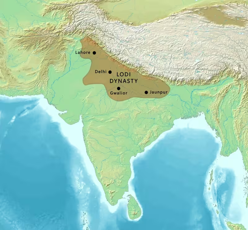
Lodi Sultanate Map: Northern India, 1451–1526 CE
Introduction
The political centre of the Lodi Sultanate moved from Delhi to Agra before returning to the battlefield at Panipat. That movement captures the changing geography of power during the final dynasty of the Delhi Sultanate: Bahlul Lodi consolidated authority from a Punjab base, Sikandar Lodi expanded eastward and established Agra as his capital, and Ibrahim Lodi faced rebellions that opened the way for Babur’s invasion in 1526.
The Lodi dynasty ruled from 1451 to 1526 CE. It began when Bahlul Khan Lodi replaced the Sayyid dynasty and ended when Ibrahim Lodi was defeated and killed by Babur at the First Battle of Panipat. Between those dates, Lodi power extended across much of northern India, though its authority depended on the submission of Afghan and Turkish chiefs, provincial governors, and recently conquered regions.
This map therefore represents more than a fixed imperial boundary. It shows a changing political landscape shaped by conquest, provincial autonomy, factional conflict, and military pressure. Jaunpur and Bihar were particularly important eastern theatres, while Punjab connected the Lodi state to the Timurid ruler Babur in Kabul. The map also marks the political centres and campaigns that transformed the Delhi Sultanate into the first Mughal imperial formation.
Historical Context
The Lodi dynasty emerged from the political fragmentation that followed the Sayyid period. Bahlul Lodi had served as governor of Sirhind in Punjab under the Sayyid ruler Muhammad Shah. He was the nephew and son-in-law of Malik Sultan Shah Lodi, who had held the governorship before him. Muhammad Shah elevated Bahlul to the status of Tarun-Bin-Sultan, and Bahlul became the strongest of the Punjab chiefs.
His power rested on a loose confederacy of Afghan and Turkish leaders. Rather than inheriting a uniformly administered empire, Bahlul had to reduce turbulent provincial chiefs and secure their submission. His personal authority supplied cohesion to a political structure in which local military leaders retained considerable influence.
On 19 April 1451, the last Sayyid ruler, Alauddin Alam Shah, abdicated in Bahlul’s favour. Bahlul then occupied the throne of Delhi. His reign was dominated by warfare against the Sharqi dynasty of Jaunpur. After prolonged conflict, he conquered and annexed the Jaunpur Sultanate and placed his eldest surviving son, Barbak, on its throne in 1486. Sharqi forces retained control of Bihar for a time and attempted to recover Jaunpur, but Bahlul again drove them back toward Bihar.
Sikandar Khan Lodi, Bahlul’s second son, succeeded him in 1489 and ruled until 1517. Born Nizam Khan, he adopted the title Sikandar Shah. His reign strengthened the administrative and territorial position of the Sultanate. His most significant territorial achievement was the conquest and annexation of Bihar from the Sharqis. He also re-founded Agra as a Muslim city in 1504 and moved the capital there from Delhi.
Ibrahim Khan Lodi succeeded Sikandar in 1517. His reign was marked by opposition from Pashtun nobles, conflict with members of his own family, and resistance from regional powers. His older brother, Jalaluddin Lodi, took up arms in the east around Jaunpur. Ibrahim defeated him, then arrested nobles who had supported the rebellion and replaced them with his own administrators. Other Afghan leaders supported Dariya Khan, the governor of Bihar.
The crisis widened when Ibrahim’s uncle, Alam Khan, and Daulat Khan Lodi, the governor of Punjab, sought Babur’s intervention. Babur crossed from his base in Kabul and entered the Punjab plains. The confrontation culminated at Panipat in April 1526, where Ibrahim was killed and the Lodi dynasty ended.
Territorial Extent and Boundaries
The Lodi Sultanate’s core lay in northern India, centred first on Delhi and later on Agra. Its western political connections extended into Punjab, where Bahlul had risen through the governorship of Sirhind and where Daulat Khan Lodi later exercised authority from Lahore. The northwestern direction also connected the Lodi political world to Kabul, the base from which Babur launched his intervention.
The eastern extent of Lodi power changed substantially during the dynasty. Bahlul’s wars against the Sharqis brought Jaunpur into the Lodi sphere, although the region remained contested. Sharqi forces continued to control Bihar after their expulsion from Jaunpur and later attempted to return. Sikandar Lodi eventually conquered and annexed Bihar, creating the dynasty’s strongest eastern expansion.
The map should distinguish between directly governed territory and regions held through military submission or provincial administration. The record does not provide a uniform boundary line for every year between 1451 and 1526. It instead identifies political centres, governorships, conquered territories, and zones of rebellion. Jaunpur and Bihar, in particular, should not be represented as permanently secure throughout the entire period.
The southern frontier is less clearly defined in the surviving account. The Deccan appears primarily in connection with a coastal trade route and the supply lines linking the coast to the interior. No detailed southern boundary for the Lodi Sultanate is established. Likewise, the western frontier should be shown as a zone of connection and military vulnerability rather than as a fully surveyed line. Punjab, Kabul, and Kandahar were central to the final crisis, but Babur’s bases were not Lodi possessions.
Administrative Structure
Lodi government combined central authority with the power of provincial governors and military chiefs. Bahlul’s rule depended on holding together Afghan and Turkish nobles through personal leadership. The sultanate’s political structure was therefore not simply a centrally managed territorial state. Provincial commanders and nobles could support, oppose, or abandon the ruler.
Sikandar Lodi attempted to impose greater discipline. He required Pashtun nobles to submit their accounts to a state audit and worked to curb their individualistic tendencies. His administrative reforms strengthened the centre and gave the Sultanate greater capacity to govern recently conquered territories. He also established sharia courts in several towns with significant Muslim populations. These courts administered Islamic law to Muslim and non-Muslim subjects.
Delhi remained the historic seat of the sultanate, but Sikandar’s foundation and capital shift made Agra the principal political centre during the later fifteenth and early sixteenth centuries. Sirhind represents the earlier Punjab base associated with Bahlul’s rise, while Lahore represents the provincial authority later exercised by Daulat Khan Lodi.
The system also relied on local officials. Hindu officers served in the revenue administration, even as the sultans supported Muslim religious scholars, Sufi shaikhs, claimed descendants of Muhammad, and members of the Quraysh tribe through stipends and revenue-free land grants. These arrangements connected political authority to religious institutions and local fiscal administration.
Infrastructure and Communications
The historical record presents roads and trade routes as strategically important, especially during the decline of Ibrahim’s reign. A coastal route through the Deccan is described as a major channel for supplies moving from the coast toward the interior. When its supply lines collapsed in the late fifteenth century, the interior political centre associated with the Lodi state became more vulnerable.
This explanation should be treated as a description of one historical interpretation of the dynasty’s decline rather than as a complete account of its economic geography. The failure to protect trade-route roads is said to have reduced commerce and weakened the treasury. A depleted treasury then limited the Sultanate’s ability to respond to internal political problems and military threats.
The move from Delhi to Agra also had an infrastructural dimension. It placed the capital within the political and military space created by Sikandar’s eastern campaigns. Agra became a base from which the sultanate could manage its northern Indian territories, including Bihar after its annexation.
No detailed postal system, road-by-road itinerary, or maritime fleet is identified. The map consequently marks broad campaign and communication corridors rather than reconstructing a complete transport network. Babur’s movement from Kabul through Punjab to Panipat is better documented as a military advance than as a formal Lodi communications route.
Economic Geography
The Lodi economy depended on agricultural revenue, trade, and the treasury controlled by the central government. Sikandar Lodi patronized trade and commerce, while Persian was used for Lodi revenue records. The administrative language of revenue collection connected provincial officers to the central state.
The account associates the Deccan with a coastal trade route whose supply lines reached the interior. Its disruption is linked to declining trade and a depleted treasury during the period of political breakdown. This makes the relationship between coast, interior, and political capital an important feature of the map, even though individual ports and commodities are not securely identified.
The conquest of Bihar expanded the territory from which the Sultanate could draw revenue. Earlier conflict with the Sharqis also shows the economic and strategic importance of the eastern plains. Control of Jaunpur and Bihar was not merely symbolic: it determined whether the Delhi-based dynasty could project authority beyond the central Gangetic region.
Religious endowments also shaped economic geography. Lodi rulers granted revenue-free lands, including entire villages, to ulama, Sufi shaikhs, and other privileged groups. Muslim subjects paid zakat, while non-Muslims were required to pay jizya in return for state protection. In some areas, Hindus also paid a pilgrimage tax. These fiscal arrangements linked religious status, landholding, and state revenue.
Cultural and Religious Geography
The Lodi sultans presented themselves as deputies of the Abbasid caliphs and acknowledged the authority of a united caliphate over the Muslim world. This political-religious language placed the dynasty within a wider Islamic framework while its actual administration remained rooted in the towns, provinces, and agrarian regions of northern India.
Sikandar Lodi pursued a strongly orthodox Sunni position. The historical record attributes to him the destruction of Hindu temples across northern India, restrictions on certain religious practices, and the execution of a Brahman who declared Hinduism as truthful as Islam. He also prohibited Muslim women from venerating the mausoleums of Muslim saints and banned the annual procession of the spear associated with the martyr Salar Masud.
At the same time, the Sultanate was religiously and administratively mixed. Hindu officers served within the revenue system, and the state governed both Muslim and non-Muslim populations. The establishment of sharia courts in towns with significant Muslim populations added an institutional layer to this diverse political geography.
Persian occupied an important place in courtly and administrative life. Lodi revenue records used Persian rather than Pashtu, while Persian also functioned as an elite literary and religious language. Sikandar himself was a reputed poet who composed under the pen name Gulrukhi. He also supported learning and ordered the translation of Sanskrit medical works into Persian.
Military Geography
Lodi military geography was shaped by the need to control provincial chiefs and secure the routes between Punjab, Delhi, Agra, Jaunpur, and Bihar. Bahlul’s campaigns against the Sharqis created the dynasty’s eastern territorial base. Sikandar’s conquest of Bihar completed the most important Lodi expansion after the annexation of Jaunpur.
Under Ibrahim, the military system was weakened by factionalism. His attempt to impose royal absolutism brought him into conflict with Pashtun nobles who expected a greater role in political decision-making. Rebellions in the east and opposition in Punjab reduced the cohesion that had supported Bahlul and Sikandar.
The decisive battle took place at Panipat in April 1526. Babur brought approximately 24,000 men armed with muskets and artillery. Ibrahim is described as having assembled approximately 100,000 men and 1,000 elephants, but his army lacked experience against gunpowder weapons and suffered from internal rivalries. Babur’s use of firearms and artillery gave his smaller force a major tactical advantage. Ibrahim and approximately 20,000 of his men died on the battlefield.
The conflict did not end all Lodi resistance immediately. Ibrahim’s brother Mahmud Lodi declared himself sultan and continued to oppose Mughal forces. He supplied around 4,000 Afghan soldiers to Rana Sanga of Mewar at Khanwa in 1527. After the defeat there, Mahmud fled eastward and challenged Babur again at Ghaghra in 1529.
Political Geography
The Lodi state was surrounded by competing centres of authority. The Sharqi dynasty of Jaunpur was the principal eastern rival during Bahlul’s reign. Although Bahlul annexed Jaunpur, Sharqi forces retained Bihar for a period and repeatedly sought to recover their influence.
Mewar under Rana Sanga represented another major regional power. Rana Sanga fought the Lodi king in multiple battles and expanded his kingdom during Ibrahim’s reign. The relationship between Rana Sanga and Babur is contested: Babur accused Sanga of sending an invitation, but that claim has not been widely accepted by scholars.
Punjab became the immediate political bridge between the Lodi Sultanate and Babur’s Timurid power. Daulat Khan Lodi, the governor of Punjab, invited Babur because of his opposition to Ibrahim. Alam Khan, Ibrahim’s uncle, also supported the Mughal intervention. Their cooperation helped Babur advance toward Delhi, although the alliance was ultimately part of a wider struggle over sovereignty.
Babur’s alliances also included the Janjua Rajputs. His forces aided them against the Gakhars in 1521, after which Janjua leaders supported his campaigns. These alliances demonstrate that the fall of the Lodi dynasty was not caused by a single external invasion alone. It resulted from the interaction of Mughal military power, provincial rebellion, Afghan factionalism, Rajput politics, and the weakening of the central treasury.
Legacy and Decline
The Lodi configuration lasted seventy-five years, from Bahlul’s accession in 1451 to Ibrahim’s death in 1526. Its most durable territorial achievements were the consolidation of the Delhi Sultanate under an Afghan ruling family, the conquest of Jaunpur, the annexation of Bihar, and the establishment of Agra as a major capital.
Its decline followed several connected pressures. Internal opposition among Pashtun nobles weakened Ibrahim’s authority. Rebellions involving Jaunpur and Bihar challenged the centre, while the governor of Punjab and Ibrahim’s uncle invited Babur to intervene. The collapse of trade-route supply lines and the depletion of the treasury further reduced the state’s capacity to sustain warfare.
Panipat transformed the political map. Babur claimed Ibrahim’s territory rather than placing Alam Khan on the throne, and the remaining Lodi territories were absorbed into the emerging Mughal Empire. Mahmud Lodi’s later resistance at Khanwa and Ghaghra shows that Lodi political claims survived beyond 1526, but the dynasty no longer controlled Delhi.
The map of the Lodi Sultanate is therefore a map of transition: from Sayyid rule to Afghan-led restoration, from Delhi to Agra, from Sharqi resistance to eastern expansion, and finally from the Delhi Sultanate to Mughal power. Its boundaries were never entirely static, but its central political geography shaped the transition that defined northern Indian history in the sixteenth century.