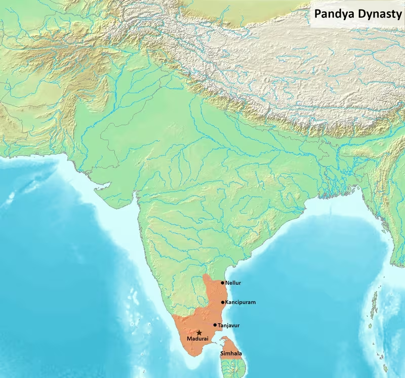
Pandya Empire at Its Height, c. 1279 CE
Introduction
The Pandya Empire reached across the southern Tamil country, the old Chola heartland, southern Kerala, parts of the Telugu country, and northern Sri Lanka during the late 13th century. This map focuses on the period between the accession of Jatavarman Sundara Pandya I in 1251 CE and the weakening of Pandya authority after the death of Maravarman Kulasekara I in 1310 CE. It presents Madurai as the principal political centre, Kanchi as a secondary capital, Korkai as an ancient maritime and pearl-trading port, and the Kaveri basin as a major zone of conflict.
The map represents a political sphere rather than a modern state with fixed borders. Pandya authority was exercised through a combination of direct rule, tribute, conquest, subordinate royal branches, and shifting alliances. The empire’s extent therefore varied by region and by ruler. Its broadest 13th-century reach was associated especially with Jatavarman Sundara Pandya I and Maravarman Kulasekara I, whose campaigns transformed the balance of power in South India.
This moment matters because it marked the reversal of several centuries of Chola predominance. The Chola kingdom had conquered Madurai and installed viceroys in the Pandya country during the 10th and 11th centuries. By the second half of the 13th century, the Cholas had become subordinate to the Pandyas, Hoysala influence had been pushed back toward the Mysore Plateau, and Pandya armies had intervened repeatedly in Sri Lanka.
Historical Context
The early Pandya country
The Pandya country, traditionally called Pandya Nadu, was centred on Madurai and the southern port of Korkai. It occupied the extreme southern part of the Tamil region and faced the Gulf of Mannar. The area’s location gave it access to both the interior Tamil plains and maritime routes connecting South India with Sri Lanka, the western coast, the Middle East, and Southeast Asia.
Pandya continuity is suggested by several kinds of evidence. Ashoka’s Major Rock Edicts, dated to the 3rd century BCE, name the Pandyas alongside the Cholas, Cheras, Satiyaputras, and the people of Tamraparni. These southern polities appear to have been outside the Mauryan Empire but within Ashoka’s diplomatic and religious horizon. The Tamil-Brahmi Mangulam inscription, generally dated to the 3rd or 2nd century BCE, mentions a Pandya ruler named Nedunjeliyan in connection with a gift of rock-cut beds to a Jain ascetic.
Greek and Latin writers also placed a southern kingdom called Pandya or Pandaia near the sea. Megasthenes described a southern kingdom ruled by a queen, while the Periplus of the Erythraean Sea referred to the Pandian kingdom and to the port of Nelcynda. Ptolemy later used names such as Pandya Mediterranea and Modura Regia Pandionis. These accounts are valuable for locating the Pandyas within wider Indian Ocean networks, although the identification of every place-name remains uncertain.
Korkai became associated with pearl fisheries in the Gulf of Mannar. Excavations at Korkai and other coastal sites have yielded Roman coins, pottery, and port remains. These finds support literary references to long-distance exchange, but they do not by themselves define the political boundary of the early Pandya state.
Revival after the Kalabhra period
The early historic Pandyas faded from prominence after the rise of the Kalabhra dynasty in southern India. Pandya power revived under Kadungon in the late 6th century CE, conventionally dated to approximately 560–590 CE. The Velvikudi copper-plate inscription presents Kadungon as the destroyer of the Kalabhra rulers.
From the 6th to the 9th centuries, the Pandyas of Madurai competed with the Pallavas of Kanchi, the Chalukyas of Badami, and later the Rashtrakutas. Their campaigns extended at different times into the Chola country, Kongu, Venadu, central Kerala, and Sri Lanka. The political geography of this period was fluid: river valleys, ports, fortresses, and dynastic alliances mattered more than a single continuous frontier.
Pandya rulers such as Sendan, Arikesari Maravarman, Maravarman Rajasimha I, Varagunavarman I, and Srimara Srivallabha are associated with expansion or warfare in the Tamil country. Varagunavarman I conquered Kongu and Venadu according to the historical record. Srimara Srivallabha invaded Sri Lanka and sacked Anuradhapura, but later suffered defeat at the hands of Pallava and Sri Lankan forces.
Chola dominance
The Cholas recovered in the 9th century. Vijayalaya Chola’s conquest of Thanjavur around 850 CE weakened Pandya control north of the Kaveri. A Pandya response under Varagunavarman II ended in defeat near Kumbakonam around 880 CE, where the Pandya army faced an alliance involving the Pallavas, Cholas, and Gangas.
Chola ruler Parantaka I invaded the Pandya territories in 910 CE and captured Madurai from Maravarman Rajasimha II. Rajasimha received support from Sri Lanka but was defeated at Vellur and fled first to Sri Lanka and then to the Chera country. Later Chola rulers continued to intervene in the south. Rajaraja I attacked the Pandyas, took Madurai, and appointed Chola viceroys with the title “Chola Pandya” to govern from the city.
The Pandya country remained a zone of resistance. Dynastic warfare, alliances with Sri Lanka and the Cheras, and the weakening of Chola power created the conditions for a Pandya revival in the late 12th and early 13th centuries.
The 13th-Century Expansion
Maravarman Sundara I
The foundations of late Pandya supremacy were laid by Maravarman Sundara I, who succeeded Jatavarman Kulasekhara in 1216 CE. He invaded the Chola country, sacked Uraiyur and Thanjavur, and forced Chola ruler Kulothunga III into exile. The Chola king later submitted formally and acknowledged Pandya overlordship.
This was not yet a permanent elimination of Chola power. Rajaraja III attempted to restore Chola independence with Hoysala support. The resulting conflict brought Pandya and Hoysala forces into the Kaveri valley. Maravarman Sundara I was defeated at Mahendramangalam, after which Rajaraja III was restored in the Chola country. The episode shows why the Kaveri basin is marked on the map as a contested frontier rather than as an uncomplicated Pandya possession.
Jatavarman Sundara Pandya I
Jatavarman Sundara Pandya I, who ascended the throne in 1251 CE, presided over the decisive phase of Pandya expansion. His campaigns moved northward into the Chola country, westward into southern Kerala, and across the sea toward Sri Lanka. His forces reached as far north as Nellore in the Telugu country.
Under Jatavarman Sundara Pandya I, the Cholas were reduced to a subordinate position. Rajendra II was subdued around 1258–1260 CE and required to pay tribute. Chola rule ended around 1279 CE with Rajendra III. The map therefore places the Kaveri delta and the central Tamil plain within the wider Pandya sphere during this period, while recognising that local administration and political allegiance could differ from direct royal control.
The Pandyas also attacked the Hoysalas. The fort of Kannanur Koppam was captured, and Hoysala ruler Somesvara was forced back toward the Mysore Plateau. Somesvara was killed in battle against the Pandyas in 1262 CE. The record further associates Jatavarman Sundara Pandya I with conflict against the Kadava ruler Kopperunjinga II and with the incorporation of the Bana or Magadai and Kongu countries into the Pandya sphere.
Kanchi became a secondary major city of the Pandya kingdom. Its inclusion on this map is important: the late Pandya Empire was not limited to the far south, but had become a power in the northern Tamil country and the southern edge of the Telugu region.
Maravarman Kulasekara I
Maravarman Kulasekara I succeeded Sundara Pandya I, who died in 1268 CE. Around 1279, a combined force associated with Hoysala ruler Ramanatha and Chola ruler Rajendra III was defeated. Maravarman Kulasekara then ruled over the Chola country and the southern Tamil-speaking portions of the Hoysala kingdom.
His reign also included intervention in Sri Lanka. The island was ruled by Bhuvanaikabahu I, and the Pandya campaign resulted in the removal of the Buddha’s Tooth Relic to the Pandya country. Sri Lanka remained under Pandya control until approximately 1308–1309 CE. The map’s depiction of northern Sri Lanka should be understood as imperial domination or political control rather than proof of uniform settlement or administration across the entire island.
Territorial Extent and Boundaries
Northern frontier
The northern reach of the empire extended into the northern Tamil country and the Telugu country. Jatavarman Sundara Pandya I’s campaigns reached Nellore, making the northern Pandya sphere considerably larger than the traditional Pandya heartland around Madurai.
The northern frontier was not a stable line. It was shaped by conflict with the Kakatiyas, the Kadavas, the remaining Chola political order, and regional chiefs. Kanchi marked a major northern centre of Pandya authority, but the historical record does not establish a single continuous boundary running from Kanchi to Nellore.
Southern frontier
The southern mainland core extended toward the tip of the Indian peninsula. Madurai was the principal capital, while Korkai connected the southern interior to the Gulf of Mannar. The sea separating southern India from Sri Lanka was not simply a barrier: it was a maritime corridor used for trade, diplomacy, warfare, and the movement of royal valuables.
The exact southern limits of Pandya authority on the mainland varied across time. The map therefore distinguishes the established heartland from the wider zone of influence in the island and coastal regions.
Eastern frontier
The eastern side of the kingdom opened toward the Bay of Bengal and the Gulf of Mannar. The Kaveri delta, Thanjavur, Uraiyur, and the coastal routes of the Chola country were central to the Pandya–Chola struggle. Korkai and other coastal sites connected the Pandya region to overseas trade.
Sri Lanka appears as a political extension of Pandya power during the late 13th century. Earlier Pandya rulers had also invaded the island. Srimara Srivallabha attacked Sri Lanka in the 9th century, while Jatavarman Sundara Pandya I and Jatavarman Vira Pandya conducted campaigns there in the 13th century.
Western frontier
The western frontier ran toward the Western Ghats, southern Kerala, Venadu, and the older Chera country. Pandya rulers repeatedly campaigned in Kongu and Venadu. Jatavarman Sundara Pandya I is associated with the conquest or subjugation of southern Kerala, while the wider Pandya period saw recurring competition with Chera and Kerala rulers.
The mountains formed a major geographical zone, but not an absolute political wall. Passes and river valleys connected the Tamil plains with the western regions. The surviving record does not define a single permanent western boundary for the imperial period.
Core lands, subordinate regions, and contested zones
Pandya political geography had several layers:
- The Madurai heartland: the core region of royal authority.
- The southern Tamil country: including the traditional Pandya Nadu and the coastal zone around Korkai.
- The Chola country: conquered, raided, subordinated, and eventually incorporated into the Pandya imperial order.
- Kongu and southern Kerala: regions repeatedly contested and at times brought under Pandya control.
- The Telugu country: reached by Pandya campaigns as far north as Nellore.
- Sri Lanka: invaded and controlled at different times, with Pandya authority particularly strong in the late 13th century.
- Hoysala frontier zones: areas around the Kaveri and Kannanur where Pandya and Hoysala power directly collided.
Because the empire was governed through several royal branches and vassal states, the coloured areas on the map represent different degrees of authority rather than uniform administrative integration.
Administrative Structure
Madurai as the imperial centre
Madurai was the principal capital and the enduring political centre of the Pandya dynasty. It was also a major cultural and religious centre of the Tamil country. Literary traditions associated the Sangams, or academies, with Madurai under Pandya patronage. These traditions are important to Tamil cultural memory, although the historicity and chronology of the Sangams remain matters of scholarly discussion.
The city’s role was both administrative and ceremonial. Royal authority was expressed through the court, temple institutions, inscriptions, coinage, and the management of subordinate rulers.
Shared royal authority
The imperial Pandya kingdom was governed through several royals, one of whom held primacy. This arrangement allowed collateral branches of the ruling family to administer large areas subject to Madurai. It also created a structural weakness: succession and precedence among royal branches could become sources of conflict.
The description of the Pandya kingdom by Marco Polo in the late 13th century refers to five royal brothers and identifies one as the crowned king. This account corresponds to the broader picture of shared dynastic authority, though foreign descriptions should not be treated as exact administrative censuses.
Vassal states and local rulers
The empire incorporated local chiefs and subordinate dynasties rather than replacing every existing political institution. The record names interactions with the Hoysalas, Kadavas, Banas, Kongu chiefs, Cholas, Cheras, and rulers of Sri Lanka. Some territories were ruled by royal relatives or vassal authorities who recognised the primacy of the Pandya monarch.
The map consequently avoids presenting every region in a single colour. Military conquest, tribute, alliance, and direct administration were distinct forms of political relationship.
Capitals and secondary centres
Madurai remained the principal capital. Kanchi became a secondary major city under Jatavarman Sundara Pandya I. Korkai retained its historical importance as a port and pearl centre. Thanjavur and Uraiyur represented the older Chola political landscape, while Nellore marked the far northern reach of Pandya campaigning.
Tenkasi belongs mainly to the later history of the dynasty. After the loss of Madurai from the 14th century, the Pandyas shifted their capital to Tenkasi and continued to rule a smaller area into the 16th century. It is included in the map’s feature set as a later successor centre, not as the principal capital of the empire in 1279 CE.
Infrastructure and Communications
The historical record provides stronger evidence for ports, rivers, campaign corridors, and maritime connections than for a formally organised road or postal system. It would therefore be misleading to draw a comprehensive imperial road network or a standardised postal system for the late Pandya Empire.
River valleys and movement
The Kaveri basin was a major corridor of warfare and political movement. Battles involving the Pandyas, Cholas, Hoysalas, Pallavas, and Gangas repeatedly took place around the river and its branches. The fertile Kaveri delta supported dense settlement and agricultural wealth, making control of the region strategically valuable.
The Tambraparni connected the southern interior with the coastal zone around Korkai. The Kollidam and other branches of the Kaveri shaped movement through the Chola country. These waterways also linked agricultural production to ports and urban centres.
Maritime connections
The Gulf of Mannar connected the Pandya mainland to Sri Lanka. It was a zone of pearl fishing, coastal exchange, diplomatic missions, and military expeditions. The repeated Pandya invasions of Sri Lanka demonstrate that the dynasty possessed the maritime capacity to move forces across the narrow sea, although the surviving record does not provide a detailed description of fleet organisation.
Korkai was the best-known Pandya port in the early historic period. Coastal sites in the Pandya region have yielded Roman coins, pottery, and port remains, supporting the existence of long-distance commerce. The maritime network extended beyond the western and eastern coasts of South Asia through commercial contacts with merchants from the Graeco-Roman world and the Middle East.
Communication through political networks
Political communication also operated through subordinate rulers, royal marriage, tribute, religious institutions, and military alliances. The division of authority among royal branches allowed the dynasty to project power over distant territories, but it required continuing negotiation. When that political balance failed after 1310 CE, military pressure from the sultanates rapidly exposed the weakness of the imperial structure.
Economic Geography
Pearl fisheries
Pearls were among the most distinctive resources of the Pandya country. Korkai, located near the Tambraparni and the Gulf of Mannar, was associated with the pearl fisheries. Greek and Latin accounts describe the wealth generated by pearls and provide details about diving practices and the export of pearls.
The pearl economy connected coastal communities, royal authority, merchants, and overseas buyers. The Pandya emblem was the fish, and fish symbols appear on coins attributed to the dynasty. The relationship between emblem, maritime wealth, and royal identity is an important feature of Pandya political geography, though the fish symbol itself should not be treated as proof that every coin bearing it came from a single ruler.
Ports and long-distance trade
The Pandya country occupied a strategic position in the Indian Ocean world. Graeco-Roman merchants visited the ancient Tamil region, while western sailors established trading settlements at harbours along the coast. The Periplus of the Erythraean Sea mentions the Pandian kingdom and the port of Nelcynda. Korkai and Alagankulam are associated with exchange and port activity in the Pandya region.
Trade connected the Tamil country with Sri Lanka, the Arabian Sea, the Red Sea, the eastern Mediterranean, and Southeast Asia. The evidence confirms long-distance commercial contacts, but it does not establish the volume of trade or a complete list of exported and imported goods.
Agricultural regions
The Kaveri delta was a particularly fertile agricultural region and a major source of political wealth. Its importance explains the repeated campaigns by the Pandyas and other dynasties. The plains around Madurai and the southern river valleys also supported agriculture and urban life.
Kongu and the western Tamil country formed another important zone, linking the interior plateau and the western routes. The map marks these regions as politically contested because Pandya control expanded and contracted there across different reigns.
Coinage
Pandya coins included silver punch-marked and die-struck copper issues, as well as some gold coins attributed to Pandya rulers. Fish symbols, elephants, bulls, Garuda figures, standing kings, and Tamil-Brahmi or Tamil legends appear in the numismatic record.
Coins bearing names such as Sundara, Sundara Pandya, Vira Pandya, and titles including Kodandaraman, Kanchi Valangum Perumal, Samarakolahalam, Bhuvanekaviram, Konerirayan, and Kaliyugaraman have been associated with the Pandyas or their feudatories. Attribution is not always certain, and some coins cannot be assigned securely to an individual king.
Cultural and Religious Geography
Tamil language and literary culture
The Pandya kingdom formed part of Tamilakam, the Tamil-speaking region of southern India. Madurai was regarded as a major centre of Tamil literary culture. Sangam poetry celebrates early Pandya rulers, including Nedunjeliyan and Mudukudimi Peruvaludi. Works such as the Mathuraikkanci and Netunalvatai describe Madurai, the Pandya country, royal courts, warfare, and commercial activity.
Some poems were traditionally attributed to rulers themselves. These literary references provide important information about political ideals and social life, but poetic praise should be read alongside inscriptions, coins, archaeology, and foreign accounts.
Jainism, Shaivism, and Vaishnavism
The early Pandya rulers are associated in the record with Jainism and Shaivism. The Mangulam inscription records a gift connected with a Jain ascetic. Later tradition describes a Pandya ruler known as Koon Pandya as converting to Shaivism.
The revival under Kadungon coincided with the prominence of the Shaivite Nayanars and Vaishnavite Alvars. By the 13th century, the Pandya country contained elite forms of Hinduism, devotional bhakti traditions, and local religious practices. Worship of Shiva and Vishnu received royal and elite support, while temples functioned as major social and economic institutions.
Temples and urban institutions
The Meenakshi Temple in Madurai is the best-known religious centre associated with the Pandya capital. Other major architectural sites connected with the broader Pandya and Tamil architectural tradition include the Jambukeswarar Temple at Tiruchirapalli, the Kallalagar Temple at Alagar Koyil, and the Nataraja Temple at Chidambaram.
Pandya contributions to Dravidian architecture developed after the Pallava and Chola periods. Temple complexes included halls, sanctums, sculpted walls, superstructures, and increasingly elaborate entrance towers or gopuras. Temples were also employers, landholders, schools, dispensaries, banks, and centres of redistribution. Their importance makes them part of the economic as well as cultural geography of the empire.
Sri Lankan religious connections
The Pandya relationship with Sri Lanka was political and religious as well as military. During the reign of Maravarman Kulasekara I, the Buddha’s Tooth Relic was carried to the Pandya country after the invasion of Sri Lanka. This event illustrates the symbolic importance of royal and sacred objects in medieval South Asian politics.
Military Geography
The Kaveri basin
The Kaveri valley was the principal military corridor between the Pandya heartland and the Chola country. Its agricultural prosperity, settlements, temples, and river crossings made it a strategic objective. Mahendramangalam and Kumbakonam appear in the record as important battle zones.
The Pandya advance northward required control of routes through the Kaveri plain. Their wars against the Cholas and Hoysalas were therefore not distant frontier conflicts but struggles over the central economic landscape of the Tamil region.
The Hoysala frontier
The Hoysalas were a major obstacle to Pandya expansion. Hoysala rulers intervened in the Chola country and at times restored Chola authority. Under Jatavarman Sundara Pandya I, the Pandyas captured Kannanur Koppam and confined Hoysala influence to the Mysore Plateau.
Somesvara’s death in battle against the Pandyas in 1262 CE represents the high point of this confrontation. Hoysala ruler Ramanatha later continued to hold against the Pandyas in some areas, showing that Hoysala resistance did not disappear immediately.
Campaigns in Sri Lanka
The sea route to Sri Lanka was a recurring military theatre. Jatavarman Sundara Pandya I invaded Sri Lanka in 1258 CE. His younger brother Jatavarman Vira Pandya conducted further campaigns between 1262 and 1264 CE and again in 1270 CE.
The island was not a permanent, uniformly administered province in the modern sense. Pandya dominance depended on military intervention, local submission, and control of political centres. Sri Lanka remained under Pandya control until approximately 1308–1309 CE.
Military organisation
The evidence identifies campaigns, alliances, royal commanders, and subordinate rulers but does not provide reliable army sizes or a complete organisation of the Pandya forces. It is therefore not possible to state the number of soldiers, elephants, ships, or garrisons with confidence.
The empire’s military geography suggests several requirements:
- Control of the Kaveri river system and its crossings.
- Access to the roads and passes connecting the Tamil plains with Kongu and Kerala.
- Strongholds in contested zones such as Kannanur.
- Maritime movement across the Gulf of Mannar.
- Cooperation or submission from subordinate royal branches.
- The ability to combine campaigns in the mainland and Sri Lanka.
Political Geography
Relations with the Cholas
The Pandya–Chola relationship changed from rivalry to subordination. Chola rulers had conquered Madurai and administered the Pandya country through viceroys. In the early 13th century, Maravarman Sundara I reversed this relationship by invading the Chola country and forcing Kulothunga III to submit.
The Cholas attempted to recover independence with Hoysala assistance. These efforts continued until the Chola line ended as a major political power around 1279 CE. By the reign of Maravarman Kulasekara I, the former Chola country was within the Pandya imperial sphere.
Relations with the Hoysalas
The Hoysalas intervened repeatedly in the Tamil country. They supported Rajaraja III against Maravarman Sundara I and later fought the Pandyas over the Kaveri basin and Kannanur. The defeat and death of Somesvara reduced Hoysala influence in the south, although Ramanatha retained a position in the region for some time.
The map’s western and northwestern frontier should therefore be read as a zone of military competition between the Pandya and Hoysala realms.
Relations with Kerala and the Chera country
The Pandyas repeatedly invaded or ruled parts of the old Chera country, including Kongu, central Kerala, southern Kerala, and Venadu. These relationships varied from conquest to alliance and resistance. The western frontier was never permanently settled by a single treaty in the historical record.
Relations with the Telugu country
Pandya armies reached the Telugu country as far north as Nellore during the expansion of Jatavarman Sundara Pandya I. The northernmost extent was shaped by conflict with the Kakatiyas and other regional powers. The record does not establish that all territory between Madurai and Nellore was governed in exactly the same way.
Relations with Sri Lanka
Sri Lankan rulers alternated between resistance, submission, and intervention in mainland politics. Sri Lankan forces supported Pandya claimants during the Chola period, while Sri Lankan kings also invaded the Pandya country. The political relationship was therefore reciprocal and unstable rather than one-directional.
Legacy and Decline
Succession crisis after 1310 CE
The death of Maravarman Kulasekara I in 1310 CE was followed by a succession struggle between his sons, Vira Pandya IV and Sundara Pandya IV. The conflict weakened the imperial structure at the moment when new military powers were entering southern India.
The Hoysala ruler Ballala III invaded Pandya territory but had to retreat when Alauddin Khalji’s general Malik Kafur invaded the Hoysala kingdom. The Khalji forces entered the Pandya country in 1311. The Pandya princes fled, and the invaders returned to Delhi with plunder after abandoning the attempt to capture them.
Further sultanate expeditions followed in 1314 under Khusro Khan and in 1323 under Jauna Khan, acting under Ghiyath al-Din Tughluq. By 1312, Pandya control over southern Kerala had been lost. Northern Sri Lanka also escaped Pandya influence by approximately 1323.
The Madurai Sultanate and later Pandyas
The former Pandya territories were incorporated into the sultanate as the province of Ma'bar. In 1334, Jalal ud-Din Hasan Khan declared independence and established the Madurai Sultanate.
Pandya rulers continued from reduced centres. The dynasty shifted its capital to Tenkasi and later ruled smaller territories around Tenkasi and Tirunelveli. Other associated centres included Kayathar, Vadakkuvalliyur, Ukkirankottai, Brahmadesam, Cheranmadevi, Ambasamudram, Kalakkad, and Pudukkottai. The Tenkasi Pandyas continued into the 16th century, although their authority was challenged by the Vijayanagara Empire and the Madurai Nayaks.
Enduring significance
The Pandya dynasty’s territorial history cannot be reduced to one fixed empire. Its political reach varied from the early heartland around Madurai and Korkai to the much larger imperial sphere of the late 13th century. The dynasty’s long history connected ancient Tamilakam, Indian Ocean commerce, the Kaveri delta, Kerala, the Telugu country, and Sri Lanka.
The map’s most important lesson is the relationship between geography and political change. Madurai provided the dynastic core; the Kaveri basin offered agricultural wealth and strategic depth; Korkai and the Gulf of Mannar opened maritime routes; the Western Ghats structured access to Kerala and the plateau; and Sri Lanka remained both a neighbouring island and a recurring field of Pandya intervention.
The imperial configuration shown here lasted only briefly in comparison with the dynasty’s full history. Yet the late 13th century remains the clearest period of Pandya supremacy, when the balance of power in South India shifted decisively away from the Cholas and toward Madurai.
Reading the Map
The map should be interpreted through degrees of control:
- Madurai and the southern Tamil country represent the dynasty’s political heartland.
- The Kaveri basin and Chola country represent territories brought into the Pandya sphere through conquest, tribute, and the end of Chola independence.
- Kanchi and the northern Tamil country reflect the reach of Jatavarman Sundara Pandya I.
- Kongu, southern Kerala, and Venadu represent western regions affected by repeated Pandya campaigns and changing allegiances.
- Northern Sri Lanka represents an overseas zone of Pandya intervention and control during the late 13th and early 14th centuries.
- The Hoysala frontier marks a zone where political authority remained contested rather than permanently fixed.
- Korkai and the Gulf of Mannar show the commercial and strategic maritime setting of the Pandya kingdom.
The boundaries are therefore historical reconstructions of political influence, not modern-style surveyed borders. Inscriptions, coins, literary works, archaeological remains, and foreign travel accounts illuminate different parts of the Pandya world, and each type of evidence has its own limits. Together they reveal how a southern Tamil dynasty became an imperial power whose influence extended across the mainland and the sea.