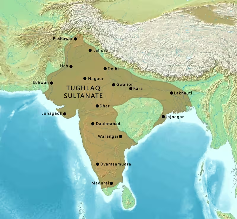
Tughlaq Sultanate at Its Territorial Zenith, c. 1335
Introduction
The Tughlaq map is defined by a striking contrast: under Muhammad bin Tughluq, the Delhi Sultanate briefly extended across most of the Indian subcontinent, yet the same expansion created distances, administrative pressures, rebellions, and fiscal crises that rapidly weakened central authority. The map's most expansive moment belongs to the campaigns of approximately 1330–1335, when armies operating from Delhi reached Bengal, the Deccan, Gujarat, Malwa, the eastern and southern peninsula, and regions connected with the north-western frontier.
The Tughlaq dynasty came to power in Delhi in 1320, when Ghazi Malik defeated Khusro Khan and assumed the title Ghiyath al-Din Tughluq. It ended in 1413, after the dynasty had lost control over much of the sultanate and Khizr Khan, formerly associated with Multan and Dipalpur, entered Delhi and established the succeeding Sayyid dynasty. Between these dates, the territory changed repeatedly. Ghiyath al-Din rebuilt authority after the violent transition from the Khalji dynasty; Muhammad bin Tughluq pursued the most ambitious programme of expansion; and Firoz Shah Tughlaq governed a reduced and increasingly decentralised realm.
This map should therefore be read as a historical sequence rather than as a single unchanging border. Campaign reach did not always mean permanent occupation, and the surviving record does not establish a uniform frontier for every year. The broadest colouring represents the maximum geographical claims and military reach associated with Tughlaq rule, while campaign zones and later revolting regions indicate the unstable character of that expansion.
Historical Context
The rise of the dynasty in 1320
The Tughlaqs succeeded the Khalji dynasty during a period of political violence in Delhi. After the death of Alauddin Khalji in 1316, palace arrests and assassinations weakened the ruling house. Khusro Khan seized power in June 1320 after killing Mubarak Khalji, but he lacked the support of many Muslim nobles and aristocrats. These elites invited Ghazi Malik, then governor in Punjab under the Khaljis, to lead an attack on Delhi.
Ghazi Malik defeated and killed Khusro Khan and took the throne in 1320 as Ghiyath al-Din Tughluq. The new ruler rewarded officials, maliks, and amirs who had helped him, while punishing those who had served his predecessor. He also built Tughlakabad, a fortified city about six kilometres east of Delhi. Its location and fortifications were associated with the need to protect the political centre from Mongol attacks.
The dynasty's ancestry remains debated. Ghiyath al-Din is commonly regarded as having Turkic or Turko-Mongol origins, but medieval accounts differ. The word “Tughlaq” itself was not an ancestral surname used by the dynasty's rulers. Literary, numismatic, and epigraphic evidence indicates that it was connected with the personal name of the founder, while the later designation “Tughlaq dynasty” became a convenient historical label.
Ghiyath al-Din's campaigns
Ghiyath al-Din's reign was short, but it established the geographic direction of early Tughlaq expansion. In 1321 he sent his eldest son Jauna Khan, later known as Muhammad bin Tughluq, toward Deogir and the kingdoms of Arangal and Tilang. The first attempt failed. Reinforcements were then dispatched, and the second campaign succeeded. Arangal fell, was renamed Sultanpur, and wealth, captives, and treasury were transferred to Delhi.
Ghiyath al-Din also intervened in Bengal. The Muslim aristocracy of Lakhnauti invited him to extend his authority eastward against Shamsuddin Firoz Shah. He placed Delhi under the authority of his son Ulugh Khan and campaigned in Lukhnauti between 1324 and 1325. The campaign succeeded, but the return journey ended in the ruler's death.
Ghiyath al-Din and his son Mahmud Khan died when a wooden structure, or kushk, collapsed. Accounts differ over the cause. One court historian attributed the death to lightning, while another explained the collapse through the movement of elephants and recorded a rumour that the accident had been planned. Several historians, including Ibn Battuta, later treated Jauna Khan as responsible for his father's death. Jauna Khan then became sultan as Muhammad bin Tughluq.
Muhammad bin Tughluq and maximum expansion
Muhammad bin Tughluq ruled for twenty-six years. His reign marks the broadest territorial reach shown on this map. Campaigns and raids extended toward Malwa, Gujarat, Mahratta, Tilang, Kampila, Dhur-samundar, Mabar, Lakhnauti, Chittagong, Sunarganw, and Tirhut. The names in the historical record refer to a wide range of regions across northern, central, eastern, and southern India.
The distinction between conquest, plunder, tribute, and durable administration is essential. Military expeditions could bring wealth and captives to Delhi without producing a stable provincial structure. The distance between Delhi and the Deccan or Bengal made regular control difficult. From 1327 onward, revolts became frequent, and after approximately 1335 the geographical reach of the sultanate began to contract.
Muhammad bin Tughluq's government also faced severe economic pressures. The sultan sharply increased taxation in the fertile lands between the Ganges and Yamuna. Court accounts describe especially heavy demands on non-Muslim cultivators, including land taxes, crop taxes, and jizya. Villages were abandoned, cultivation declined, and famine followed. The court historian Ziauddin Barani described the social and fiscal consequences in severe terms.
The sultan's experiments with token coinage added to the instability. Brass and copper coins were issued with the face value of silver coins, but counterfeiting became widespread. Accounts describe households and provincial populations producing imitation coins, forcing the state to redeem both genuine and counterfeit pieces at considerable cost. These monetary and agrarian crises weakened the financial basis of long-distance campaigns.
Revolt and contraction after 1327
The southern and eastern provinces were the first major areas to escape effective control. Jalaluddin Ahsan Khan, a soldier from Kaithal, established the Madurai Sultanate in the south. The Vijayanagara Empire emerged in southern India in response to Delhi's campaigns and became a major force opposing Tughlaq authority. In 1336, Kapaya Nayak of the Musunuri Nayak family defeated the Tughlaq army and reconquered Warangal.
In Malwa, Muhammad bin Tughluq's own nephew rebelled in 1338. The sultan attacked, captured, and executed him. By 1339, eastern regions under local Muslim governors and southern territories ruled by Hindu kings had revolted or declared independence. In 1347, the Deccan became an independent Muslim kingdom after a revolt led first by Ismail Mukh and then by Zafar Khan, who founded the Bahmanid Sultanate.
Muhammad bin Tughluq died in March 1351 while pursuing rebels and tax resisters in Sindh and Gujarat. At his death, the sultanate's effective geographical control had contracted to the north of the Narmada River. The map's broadest territorial colouring must therefore be distinguished from the smaller area of durable authority that remained at the end of his reign.
Firoz Shah Tughlaq and a reduced realm
A collateral relative, Mahmud Ibn Muhammad, ruled for less than a month after Muhammad bin Tughluq's death. Muhammad's nephew Firuz Shah Tughlaq then became sultan and ruled for thirty-seven years. His reign was considered by court historians to be more merciful than that of his predecessor, although it also witnessed religious discrimination, political conflict, and the continuing weakening of the central state.
Firoz Shah attempted to recover the former boundary through an eleven-month war against Bengal in 1359. Bengal did not fall and remained outside Delhi's authority. Militarily, Firoz Shah was less effective than the rulers who had created the earlier expansion. He concentrated instead on irrigation, construction, religious institutions, mosques, madrasas, bridges, and other public works.
After the death of his heir in 1376, succession tensions intensified. Firoz Shah's illness and the rivalry between his wazir Khan Jahan II and his son Muhammad Shah produced the first civil war in 1384, followed by further struggles after Firoz Shah's death in 1388. These conflicts made the capital and its surrounding territories the centre of competing claims rather than the secure headquarters of a subcontinental empire.
Territorial Extent and Boundaries
Northern frontier
The northern part of the sultanate included Delhi, the Punjab, and regions connected with the Himalayan foothills. The exact frontier fluctuated, and the surviving account does not provide a continuous boundary line. Punjab was strategically important both because it connected Delhi with the north-west and because it had long been exposed to Mongol pressure.
Muhammad bin Tughluq also attempted a campaign toward China through the Himalayas. A force of approximately 100,000 soldiers was sent over the mountains in 1333. The account states that Hindu forces closed the passes and prevented retreat. Kangra's Prithvi Chand II defeated the army, and nearly all the soldiers perished. The campaign demonstrates how the Himalayan terrain limited expansion even when the Delhi state could assemble a large army.
In the later fourteenth century, predominantly Hindu populations in the Himalayan foothills rebelled and stopped paying jizya and kharaj. The northern frontier was therefore not simply a line dividing the sultanate from external states; it was also a zone of local resistance and changing fiscal control.
Southern frontier
The southern extent shown on a map of Tughlaq expansion includes the Deccan and campaign zones farther south. Deogir, later renamed Daulatabad, became central to Muhammad bin Tughluq's southern policy. The city was selected as a second administrative capital, and the sultan ordered the Muslim population of Delhi—including members of the royal family, nobles, religious scholars, and other elites—to move there.
The move was designed to connect administration with the Deccan and support the sultan's wider ambitions. It was also coercive. Officials and nobles who refused were punished, and the journey became a lasting source of resentment. When Mongols appeared in Punjab, the elite was allowed to return to Delhi, although Daulatabad remained an administrative centre and a Muslim elite continued to live there.
The southern frontier soon became the most serious challenge to Delhi. Warangal was reconquered from Tughlaq authority in 1336. The Madurai Sultanate, Vijayanagara, and other southern powers reduced Delhi's reach. By 1347 the Deccan had become independent under the Bahmanid Sultanate. The map should thus show southern territories as campaign zones or unstable possessions rather than assume a permanent uniform occupation.
Eastern frontier
The eastern campaigns reached Bengal and the regions associated with Lakhnauti, Chittagong, and Sunarganw. Ghiyath al-Din's intervention in Bengal began after an invitation from local Muslim aristocrats. Muhammad bin Tughluq's reign continued to include eastern campaign objectives, but distance and local political autonomy made Bengal difficult to retain.
Firoz Shah's campaign against Bengal in 1359 lasted eleven months without bringing the region back under Delhi's authority. Bengal remained outside the effective boundary of the sultanate. The eastern frontier was therefore a region where military intervention could be substantial but could not easily be converted into lasting central rule.
Western frontier
The western side of the map includes Gujarat, Sindh, Multan, and the north-western approaches to Delhi. Gujarat was among the regions attacked during Muhammad bin Tughluq's expansion and later became associated with rebellion and separation from Delhi.
The system of tax farming contributed to western instability. In 1377, the noble Shamsaldin Damghani contracted for the iqta of Gujarat and promised an enormous annual tribute. His attempt to extract the promised amount failed. He paid nothing to Delhi and declared rebellion with other nobles. Soldiers and peasants in Gujarat refused to support the conflict, and Shamsaldin Damghani was killed.
Sindh also remained politically important at the end of Muhammad bin Tughluq's life. The sultan died while pursuing rebels and people who resisted taxation in Sindh and Gujarat. Later, Khizr Khan's power base included Multan, Dipalpur, and parts of Sindh. His eventual entry into Delhi in 1414 followed the disintegration of Tughlaq authority.
Natural boundaries and contested zones
The Ganges-Yamuna region formed the most economically valuable agrarian zone described in the record. The Narmada is significant because the account places the remaining area of effective Tughlaq control north of that river at Muhammad bin Tughluq's death. The Himalayas formed a formidable military barrier, as demonstrated by the failed campaign toward China.
No single mountain range or river fixed the full political boundary of the dynasty. Control depended on garrisons, governors, tax collection, the loyalty of nobles, and the ability to move armies. Regions might be conquered, plundered, taxed, or claimed without being fully integrated into the central administration.
Administrative Structure
Delhi and Tughlakabad
Delhi was the principal capital and political centre of the dynasty. Ghiyath al-Din's construction of Tughlakabad added a fortified royal city east of Delhi. The fort's defensive character reflected the continuing concern over Mongol attacks and the vulnerability of the northern capital.
During the civil wars of the 1390s, Delhi ceased to function as the uncontested centre of the sultanate. Tartar Khan installed Nasir-al-din Nusrat Shah at Firozabad, a few kilometres from the seat of the rival Nasir-al-din Mahmud Shah. Two sultans then claimed authority, each controlling a limited territory and a faction of the nobility. The map's capital symbols should therefore distinguish the stable political centre of the earlier dynasty from the divided capital region of the later period.
Daulatabad as a second capital
Muhammad bin Tughluq's decision to use Daulatabad as a second administrative capital was one of the most consequential geographical experiments of the dynasty. The city, formerly Deogir, occupied a position in the Deccan that could support communication with southern territories more effectively than Delhi.
The forced transfer of Delhi's Muslim elite reveals the coercive character of Tughlaq administration. The movement included nobles, members of the royal family, Sayyids, shaykhs, and religious scholars. The policy was connected with the sultan's plans for world conquest and with his expectation that religious elites would help extend Islamic influence in the Deccan. The order also generated hatred among nobles and imposed enormous human and administrative costs.
Iqta, governors, and tax extraction
The Tughlaqs governed through a system in which family members, Muslim aristocrats, military commanders, and provincial officials received authority over iqta territories. A na'ib held the right to collect taxes from non-Muslim peasants and local economies under a contract requiring a fixed payment or tribute to the sultan's treasury.
Subcontracting allowed a na'ib to assign villages to amirs and commanders, who then extracted produce and property. Under the arrangement described for the period, surplus collections were divided between the provincial authority and the sultan. Firoz Shah later altered the proportion in favour of the nobles. The system encouraged corruption because officials had incentives to demand more than the agreed assessment.
Tax farming connected political geography with rural suffering. When officials could not meet their contracted obligations, they sometimes used force, failed to remit revenue, or rebelled. The resulting conflicts were not limited to distant frontiers; they also affected villages and agricultural districts close to the centre.
Religious and legal administration
The sultans presented themselves as Muslim rulers and used religious and legal officials within the court and provinces. Muhammad bin Tughluq was educated in the Quran, fiqh, poetry, and other fields, but his rule included harsh punishment of opponents and suspected rebels, including Muslims, Sufis, Qalandars, Sayyids, and other officials.
Firoz Shah claimed to prohibit the extreme tortures associated in his memoir with earlier rulers. At the same time, his rule was marked by discrimination against Shia and Mahdi groups and by the persecution of Hindus who attempted to rebuild destroyed temples. He also raised and systematised jizya, including its assessment on Brahmins, and offered exemptions and rewards to converts to Sunni Islam.
Infrastructure and Communications
The available account does not preserve a complete map of roads, postal stations, or merchant routes under the Tughlaqs. It would therefore be misleading to draw a fully reconstructed communications network. The movement of armies, officials, tax collectors, religious scholars, and displaced elites nevertheless demonstrates the existence of long-distance connections linking Delhi with Bengal, Gujarat, Sindh, the Deccan, and the southern peninsula.
The transfer from Delhi to Daulatabad was the largest administrative movement described here. It required the relocation of the capital's Muslim elite over a great distance and exposed the practical difficulties of governing a realm extending from the northern plains into the Deccan. Military campaigns similarly depended on long supply lines and on the ability to move cavalry and infantry through plains, plateau country, forests, river regions, and mountains.
Firoz Shah invested in more durable infrastructure. He sponsored irrigation canals, bridges, mosques, madrasas, and other Islamic buildings. Canals connecting the Yamuna with the Ghaggar and the Yamuna with the Sutlej are associated with his reign, and the account states that these irrigation works continued in use into the nineteenth century.
The canal projects had both economic and political importance. Irrigation could support cultivation and revenue in areas affected by famine and abandoned villages. Construction also expressed the sultan's ability to mobilise labour and resources after the fiscal exhaustion of Muhammad bin Tughluq's reign.
The map does not include a maritime layer. Although campaigns reached regions associated with Bengal, Gujarat, and the southern coast, the historical account does not provide enough information to reconstruct Tughlaq naval capabilities, port administration, or a specific sea-trade system.
Economic Geography
Agricultural regions
The fertile lands between the Ganges and Yamuna were central to the sultanate's fiscal geography. Muhammad bin Tughluq's government raised land taxes sharply in this area, with some districts reportedly facing increases of tenfold and others of twentyfold. Non-Muslim cultivators also faced crop taxes requiring the surrender of half or more of their harvest.
The pressure damaged the agricultural base on which the state depended. Villagers abandoned cultivation and escaped into forests, while others became robber groups. Famines followed. The account also describes a prolonged famine that affected Delhi and much of India after the token-coin experiment. These crises reveal the danger of treating a large agrarian zone as an unlimited source of revenue.
Firoz Shah's canals represented an attempt to restore productive capacity. Irrigation projects linked political authority to the management of water and agriculture, particularly in the northern plains.
Tribute, plunder, and provincial revenue
The Tughlaq state acquired wealth through several channels. Campaigns against non-Muslim kingdoms produced plunder, ransom, and captives. Provincial governors and nobles collected land taxes, crop taxes, jizya, and other levies. The iqta system connected military service and aristocratic income to the extraction of rural revenue.
This system was unstable because the central treasury depended on payments from provinces that were often distant and rebellious. When campaigns became expensive and agricultural regions were impoverished, the state could no longer support large armies. The planned campaigns toward Khurasan and Iraq illustrate this problem. More than 300,000 horses were reportedly gathered near Delhi and maintained for a year, but the project was abandoned after the treasury was depleted and soldiers refused to serve without pay.
Coinage and economic crisis
The introduction of brass and copper token coins was intended to supplement the silver currency. Instead, ordinary people could produce counterfeits from metal available in their homes. Ziauddin Barani described villages producing fake coins to meet tribute, tax, and jizya demands.
The state eventually had to redeem both genuine and counterfeit coins. This decision created further expense and left large accumulations of withdrawn currency. The episode demonstrates how monetary policy connected Delhi to distant provincial economies: a coin issued in the capital could affect tax collection, military payment, and everyday exchange across the sultanate.
Markets and slavery
Military expansion also shaped the geography of slavery. The account states that campaigns and raids against non-Muslim kingdoms resulted in the seizure of slaves. Markets in foreign and Indian slaves operated during the reigns of Ghiyath al-Din, Muhammad bin Tughluq, and Firoz Shah.
Ibn Battuta recorded the presence of enslaved people in the Delhi court and described slave boys and girls being sent with diplomatic missions as gifts. These observations belong to the social and economic history of the sultanate, but the available account does not identify a complete network of slave markets or the volume of trade between particular cities.
Cultural and Religious Geography
The Tughlaq realm contained Muslim, Hindu, Jain, Sufi, Shia, and Mahdi communities. Religious identity shaped taxation, political legitimacy, court patronage, and military conflict. It did not, however, produce a simple geographical division. The sultanate's towns, villages, courts, and military settlements contained communities with different religious affiliations.
Muhammad bin Tughluq's transfer of the Delhi elite to Daulatabad was partly intended to extend Islamic political and religious influence in the Deccan. The sultan expected religious figures and Sufis to adapt Islamic symbolism to imperial aims and to persuade inhabitants of the Deccan to convert. The movement also created a more stable Muslim elite in Daulatabad, according to the account, even after many people returned to Delhi.
The expansion of Tughlaq authority was accompanied by the destruction and desecration of Hindu and Jain temples in parts of the Deccan. The Swayambhu Shiva Temple and the Thousand Pillar Temple are cited as examples. Under Firoz Shah, the state continued to restrict the rebuilding of temples and punished targeted religious groups, while also patronising Sunni institutions.
The dynasty's architectural geography included fortified cities, mosques, madrasas, canals, bridges, and the reuse or installation of ancient Hindu and Buddhist pillars near mosques. Firoz Shah was especially associated with Indo-Islamic architecture and with the installation of lats. These projects gave visible form to the authority of the sultan and linked the built environment with religious and political claims.
Persian was central to court culture and historical writing, while the territories governed by the sultanate contained many regional languages and literary traditions. The account does not provide a detailed linguistic map, so language boundaries should not be inferred from the political colouring.
Ibn Battuta's memoir is an important narrative window onto the court and capital. He arrived in India in 1334, during the period of greatest Tughlaq geographical reach. He presented Muhammad bin Tughluq with gifts and received silver dinars, a house, and appointment as a judge with rights to collect taxes from two and a half Hindu villages near Delhi. His descriptions also record court punishments, famine, corruption, and the treatment of religious figures.
Military Geography
Armies and campaign zones
The Tughlaq military system depended on cavalry, provincial forces, nobles, and the mobilisation of large armies from the northern centre. The historical account mentions a force of more than 300,000 horses assembled for the proposed Khurasan campaign and an army of approximately 100,000 sent toward China through the Himalayas.
These figures come from medieval historical accounts and should be treated as reported numbers rather than precise modern censuses. They nevertheless convey the scale of the military ambitions associated with Muhammad bin Tughluq. The same armies were difficult to maintain. Unpaid soldiers, exhausted treasuries, long supply routes, and hostile terrain repeatedly undermined imperial plans.
The military geography of the sultanate was therefore strongest in accessible plains near the northern centre and more fragile in distant plateaus, riverine eastern regions, and mountain corridors. The failed Himalayan campaign shows the limits imposed by terrain. The loss of Warangal, Bengal, the Deccan, and southern territories shows the limits imposed by distance and local resistance.
Strongholds and defensive centres
Tughlakabad was constructed as a defensible city east of Delhi. Its fortifications were associated with the threat of Mongol attacks and with the need to protect the capital. Delhi itself remained the principal political and military centre, while Daulatabad served as a southern administrative base.
The account does not provide a complete list of forts or garrison towns. It would therefore be inappropriate to represent every named city as a military stronghold. Warangal, Kangra, Delhi, Tughlakabad, Daulatabad, Multan, and the Himalayan passes can be marked because they are directly connected with campaigns, defence, or political authority in the historical record.
Rebellion as a geographic process
Rebellion was not an occasional disturbance at the edge of the empire. It became a defining feature of Tughlaq political geography. Revolts began in 1327 and continued through Muhammad bin Tughluq's reign. His nephew rebelled in Malwa; local governors and southern rulers asserted independence; Bengal remained outside Delhi's control after Firoz Shah's campaign; and nobles in Gujarat and elsewhere used their provincial authority to resist the centre.
During the civil wars after Firoz Shah, Hindu populations in the Himalayan foothills and the southern Doab stopped paying taxes. Muhammad Shah attacked rebels near Delhi and Etawah in 1392, with mass executions and the destruction of Etawah described in the historical account. By the 1390s, the former subcontinental realm had become a patchwork of smaller Muslim sultanates and Hindu kingdoms.
Timur's invasion
Timur's invasion in 1398–1399 marks the lowest point of the dynasty. The Delhi Sultanate was already divided between rival sultans when Timur defeated its armies and entered Delhi. Sultan Mahmud Khan fled. Delhi was plundered, its population massacred, and more than 100,000 prisoners were reportedly killed.
The invasion intensified an existing political crisis rather than creating the entire collapse by itself. The city had been weakened by civil war, factional rivalry, provincial separation, and the loss of effective authority over much of the subcontinent. Timur's departure left the Delhi region in further disorder and made recovery difficult for generations.
Political Geography
The Tughlaq state bordered or confronted several kinds of political power. In the south, Vijayanagara emerged in response to Delhi's attacks, while the Madurai Sultanate and later the Bahmanid Sultanate represented independent Muslim powers. Bengal retained its autonomy after Firoz Shah's unsuccessful campaign. Rajput states later expelled the governor of Ajmer and asserted control over Rajputana.
The relationship between Delhi and neighbouring regions was not always direct warfare. Ghiyath al-Din's intervention in Bengal followed an invitation from local Muslim aristocrats. Provincial elites could invite the sultan, contract with him, serve as governors, or rebel against the obligations they had accepted. Their choices shaped the actual map more than royal claims alone.
The relationship with Mongol forces also influenced the northern political landscape. Tughlakabad's fortifications were linked with defence against Mongol attacks, while the arrival of Mongols in Punjab affected the decision to allow the Delhi elite to return from Daulatabad.
By the 1390s, rival claims existed even within Delhi. Nasir-al-din Mahmud Shah and Nasir-al-din Nusrat Shah claimed sovereignty from nearby political centres, with the latter based at Firozabad. Their nobles changed sides, battles occurred repeatedly, and neither claimant could reunify the former sultanate.
After Timur's invasion, Khizr Khan expanded from Multan, Dipalpur, and parts of Sindh. He entered Delhi victoriously on 6 June 1414, after the formal end date commonly assigned to Tughlaq rule, and established the Sayyid dynasty. The transition illustrates how a regional governor could become the founder of a new Delhi regime once the old imperial structure had fractured.
Legacy and Decline
The Tughlaq territorial configuration lasted only briefly at its maximum. The dynasty ruled from 1320 to 1413, but the map of c. 1335 was already under pressure from revolts that had begun in 1327. Muhammad bin Tughluq's ambition brought the Delhi Sultanate to its widest geographical reach, yet the costs of campaigning, forced migration, heavy taxation, monetary experimentation, and provincial administration made that reach difficult to sustain.
The contraction was accelerated by the independence of the Deccan, Bengal, Sindh, and Multan; the growth of Vijayanagara and other Hindu kingdoms; the formation of Gujarat, Malwa, and Jaunpur; and the assertion of Rajput authority in Rajputana. Timur's invasion in 1398 devastated Delhi and exposed the weakness of the divided sultanate. Civil war among the Tughlaq successors prevented recovery.
The dynasty's legacy was not limited to its territorial failure. Its rulers reshaped the political geography of northern and peninsular India through campaigns, administrative experiments, capital transfers, taxation, irrigation, and architecture. Daulatabad became a lasting symbol of the possibilities and dangers of centralising a large subcontinental state. Firoz Shah's canals remained in use long after his reign. Tughlakabad and other construction projects preserved the material imprint of the dynasty's defensive and religious ambitions.
The map's central lesson is that imperial extent and effective control were not identical. Inscriptions, court histories, administrative accounts, and Ibn Battuta's memoir portray a state capable of moving armies and officials across extraordinary distances, but also one repeatedly limited by terrain, famine, financial exhaustion, local resistance, elite rivalries, and the difficulty of transmitting authority from Delhi. The Tughlaq Sultanate reached its greatest size under Muhammad bin Tughluq, but its most enduring historical significance lies in the tension between that immense geographical ambition and the rapid fragmentation that followed.