Overview
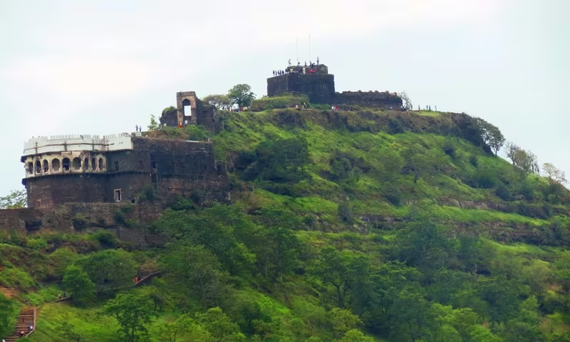
Daulatabad Fort rises on a conical hill about 200 metres high near present-day Aurangabad in Maharashtra. Originally known as Devagiri or Deogiri, the citadel became the capital of the Yadavas, a briefly chosen capital of the Delhi Sultanate, and later a secondary capital of the Ahmadnagar Sultanate. Its history is therefore not the story of a single dynasty, but of successive powers adapting one exceptionally defensible site.
The fortress combines natural and constructed barriers. Yadava rulers cut away much of the lower hill to create near-vertical sides, while later rulers added moats, double ramparts, bastions, palaces, mosques and towers. The surviving complex represents roughly a thousand years of building and occupation, from early Hindu and Jain remains to Bahmani, Ahmadnagar and Mughal structures.
Etymology and Names
The name Devagiri is commonly understood as “hills of god.” Hindu lore connects the surrounding hills with Lord Shiva, providing a religious explanation for the older name. The site is also called Deogiri in historical and modern usage.
In the 14th century, Muhammad bin Tughluq renamed Devagiri Daulatabad, a name that continued through later periods. By then, the city had already become a major political and military centre. The name Devagiri remains closely associated with the Yadava capital and the original hill-fortress.
Geography and Location
Daulatabad lies approximately 16 kilometres northwest of Aurangabad and midway along the route to the Ellora Caves. The settlement stands in the Deccan uplands, near caravan routes leading toward western and southern India. This position helped Devagiri develop as an important town by around the 6th century CE, although the site itself had been occupied since at least 100 BCE.
The central hill provided the fortress with its most powerful natural defence. Its slopes were reshaped until they rose almost vertically for about 50 metres above the surrounding ground. Access to the summit was restricted to a narrow bridge and a long gallery excavated through the rock. These features allowed the garrison to control movement into the inner fort.
Ancient History
Archaeological and architectural remains indicate occupation at the site from at least 100 BCE. The area contains the remains of Hindu and Jain temples comparable in some respects to those at Ajanta and Ellora. A series of niches carved with Jain Tirthankaras survives in Cave 32, showing that Jain religious activity formed part of the site's early history.
By around the 6th century CE, Devagiri had become an important upland settlement. Its location along routes toward western and southern India gave it a commercial and strategic context even before it became a royal capital. The large fortified city visible today developed gradually as successive rulers strengthened the hill and extended defences around it.
Historical Timeline
Yadava Capital
The city is traditionally associated with Bhillama V, who established Yadava power in the western Deccan after breaking from the Chalukyas. Around 1187, he is said to have founded Devagiri and initiated the hill fortress. The Yadavas made it their capital, and the citadel became the core of their political authority.
During the reign of Ramachandra, Alauddin Khalji raided Devagiri in 1296. The Yadavas were compelled to pay a substantial tribute. When those payments stopped, Alauddin sent another expedition in 1308. Ramachandra was then forced to become his vassal, and Devagiri was annexed to the Delhi Sultanate.
Delhi Sultanate
Muhammad bin Tughluq made Devagiri the focus of an ambitious imperial experiment. In 1327, or during the closely associated events of 1328, he renamed the city Daulatabad and shifted the capital of the Delhi Sultanate from Delhi. A mass migration from Delhi was ordered.
The reasons for the move remain a subject of historical interpretation. Some scholars have regarded Daulatabad's position as relatively central within the sultanate and more secure from attacks approaching from the northwest. Yet the new capital faced serious difficulties, including an arid and dry environment. The strategy failed, and in 1334 the capital was shifted back to Delhi. The episode later contributed to Muhammad bin Tughluq's reputation as the “Mad King,” though the move also had a geographical and strategic rationale.
Bahmani and Ahmadnagar Rule
The next major phase followed the rise of the Bahmani Sultanate. Hasan Gangu Bahmani, also known as Ala-ud-Din Bahman Shah, is associated with the construction of the Chand Minar. The tower was built as a replica of Delhi's Qutb Minar, which Hasan Gangu admired. Iranian architects were employed, and lapis lazuli and red ochre were used in its colouring.
In 1446, Alauddin Bahmani constructed another tall tower within the sector known as Mahakot to commemorate the capture of Daulatabad. The Chand Minar is situated close to the Jami mosque and remains among the most recognisable structures in the complex.
In 1499, Daulatabad became part of the Ahmadnagar Sultanate and served as its secondary capital. Many of the fortifications visible today were constructed or substantially developed under the Bahmani and Ahmadnagar rulers. In 1610, Malik Ambar established the nearby city of Khadki, later known as Aurangabad, as the capital of the Ahmadnagar Sultanate.
Mughal and Maratha Control
The Mughals captured the fortress in 1632 or 1633 under the Deccan administration of Shah Jahan. An Ahmadnagar prince was imprisoned after the capture. The Chini Mahal, a palace associated with the Ahmadnagar period, was later converted into a prison by the Mughals. It is reputed to have held Abul Hasan Qutb Shah of Golconda.
Daulatabad also contains Mughal buildings associated with Shah Jahan, including a palace beneath the northern side of Balakot. The Maratha Empire captured the fortress in 1760, marking another change in control of the strategic citadel.
Political Significance
Daulatabad's importance came from the combination of capital, fortress and transport position. Under the Yadavas, Devagiri was the centre of a regional dynasty. Under Muhammad bin Tughluq, it was briefly elevated to the capital of a large sultanate. Under the Ahmadnagar rulers, it operated as a secondary capital while remaining a major military centre.
The fort's architecture reflects the political competition of the Deccan. Each ruling power inherited a defensible site and modified it for its own needs. The result is not a single unified monument but a fortified urban landscape containing royal residences, religious buildings, towers, prisons, walls and military approaches from different periods.
Religious and Cultural Importance
The region's religious history is represented by Hindu and Jain remains. The Tirthankara niches in Cave 32 are especially important evidence of Jain presence. Later Islamic rulers added the Jami mosque, the Chand Minar and other buildings associated with Bahmani, Ahmadnagar and Mughal rule.
The fort therefore preserves multiple religious and architectural traditions within one complex. Its structures also show the movement of artistic and technical ideas across the Deccan. The Chand Minar, for instance, was consciously modelled on the Qutb Minar of Delhi and built with the participation of Iranian architects.
Economic Role
Devagiri's economic importance was connected to its position near caravan routes leading toward western and southern India. Its upland location linked the settlement to movement across the Deccan, while its fortified hill offered protection for the political centre that controlled the surrounding territory.
The original capital city once spread widely around the hill. Today, much of that urban area is unoccupied and has contracted into a village. Its survival is closely tied to visitors who come to see the fort and the neighbouring historic landscape.
Monuments and Architecture
The fortified city is divided into three principal zones: Balakot, Kataka and Ambarkot.
Balakot is the innermost fortification, situated on the conical hill itself. The Yadavas scarped the hill to create steep sides and excavated a deep moat at its base. The area contains palatial buildings, including the Chini Mahal. The palace is in a ruined condition and survives primarily as a long hall with an entrance on one side. Its name refers to the blue and white tiles once set into its facade.
Balakot also contains a ruined royal residence from the 15th century, built during the early Bahmani period. Beneath the hill are Mughal structures attributed to Shah Jahan, including two courts, an apartment building and a hammam. Another pavilion stands beneath the summit.
Kataka is the circular intermediate fortification, built as an expansion of Balakot. Its massive defensive wall has two ramparts, bastions and moats. A Mughal-era hammam stands outside its eastern entrance. Within the complex is the Jami mosque, dated to 1318.
The Chand Minar stands near the mosque in the Mahakot sector. Its lower portion is concealed by a small structure containing a mosque. The tower is currently out of bounds to tourists following a suicide case.
Ambarkot is the outermost defensive wall and encloses much of the historic city. It is elliptical, extends roughly two kilometres from north to south, and has two defensive walls. It is commonly attributed to Malik Ambar, though it may have been built by the Tughluqs. Several historic structures around its walls remain insufficiently investigated.
Military Design
Daulatabad's defensive system was designed to slow, confuse and trap attackers. The fort had a single entrance and exit rather than separate routes, forcing invading soldiers deep into the complex while they searched for a way out. Its gates were not arranged in parallel, which prevented an attacking force from maintaining momentum.
The placement of false and real gates added to the confusion. Attackers were expected to turn left toward a visible flag mast, while the actual gates lay to the right. Curved walls, false doors and complicated entryways made it difficult to understand the fort's plan from within.
The gate spikes were intended to counter war elephants used as battering rams before the widespread use of gunpowder. A rock-cut gallery led upward through the hill. At one point, steep stairs were covered by a grating designed to serve as the hearth of a huge fire maintained by the garrison above during war. A cave entrance at the midpoint was intended to mislead enemies. Massive cannon placed at intervals faced out over the surrounding countryside.
Decline and Revival
Daulatabad's political role declined as capitals and administrative centres shifted elsewhere. The founding of Khadki near the fort in 1610 signalled the growing importance of the neighbouring city that later became Aurangabad. After the Maratha capture in 1760, Daulatabad no longer served as the centre of a major imperial capital.
The historic city subsequently became largely unoccupied and was reduced mostly to a village. The fort, however, remains a major heritage site because its walls and buildings preserve the successive military and political histories of the Deccan.
Modern City
Daulatabad is accessible from Aurangabad by road along the Aurangabad–Ellora route. It is also served by Daulatabad railway station on the Manmad–Purna section of South Central Railway. Aurangabad is the major nearby railway station, and the Devagiri Express connects Mumbai and Secunderabad via Aurangabad.
Today, the fort's significance lies in the exceptional survival of its fortified landscape. Visitors encounter not just a single monument but a city enclosed by successive defensive zones, with Hindu and Jain remains, Islamic religious buildings, royal residences, prisons, towers and rock-cut military passages.