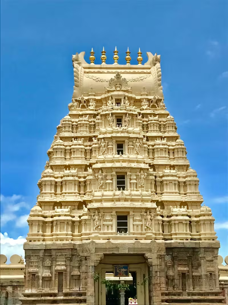
Overview
On 4 May 1799, the fort of Seringapatam fell after the decisive assault of the Fourth Anglo-Mysore War, and Tipu Sultan was killed within its walls. The event transformed the political history of Mysore, but it did not erase the older identity of the place. Srirangapatna remained a sacred island town centred on the Ranganathaswamy temple, a Kaveri pilgrimage site, and a settlement whose history reaches back to the early medieval period.
Srirangapatna stands about 15 kilometres from Mysore, in Mandya district of Karnataka. The entire historic town occupies an island formed by the Kaveri River. The main channel runs along its eastern side, while the Paschima Vaahini branch flows to the west. This setting gave the town religious meaning and military advantages: water enclosed the settlement, while the fort protected the approach to Mysore, the capital of the kingdom.
Its monuments preserve several layers of history. The Ranganathaswamy temple reflects Ganga foundations and later Hoysala and Vijayanagar additions. The fort, dungeons, palace gardens, mosque, mausoleum, bridge, cemeteries, and battle memorials recall the Wodeyar kingdom, the rule of Hyder Ali and Tipu Sultan, and the British conquest. The monuments of the island have been nominated for UNESCO World Heritage status, with the application on the tentative list.
Etymology and Names
Srirangapatna takes its name from the Ranganathaswamy temple dedicated to Ranganatha, a manifestation of Vishnu. The name is also written as Srirangapattana. During British rule, the town was commonly called Seringapatam. Both forms remain important for understanding its history: Srirangapatna expresses the town's long association with the deity and the Kaveri pilgrimage tradition, while Seringapatam appears prominently in accounts of the Anglo-Mysore wars and the 1799 battle.
The temple's deity is identified with Adi Ranga, or the “first Ranga.” Tradition holds that the major islands formed by the Kaveri are consecrated to Ranganatha and contain ancient temples dedicated to him. The three principal sites are Srirangapatna, known as Adi Ranga; Shivanasamudra, known as Madhya Ranga; and Srirangam in Tamil Nadu, known as Antya Ranga.
Geography and Location
Srirangapatna lies at approximately 12.41° north and 76.7° east, at an average elevation of 679 metres above sea level. Its island geography is defined by the Kaveri and the Paschima Vaahini channel. The river is not merely a physical feature: its waters are regarded as auspicious, and the Paschima Vaahini section is especially sacred for immersion of ashes and the performance of rites for ancestors.
The island's position also shaped its political and military importance. The town was close to Mysore but situated in the neighbouring district of Mandya. As the fortress nearest to the capital, Srirangapatna served as the kingdom's last major defensive position in the event of invasion. The river approaches, fortified walls, and controlled gateways made the site particularly valuable to rulers who wished to secure Mysore.
Today, Srirangapatna is connected by rail to Bengaluru and Mysore and by road through National Highway 275. The highway passes through the town, and measures were taken to reduce its effect on the historic monuments.
Ancient and Early Medieval History
Srirangapatna had long been an urban centre and pilgrimage destination before it became a capital or battlefield. The most visible early foundation is the Ranganathaswamy temple, consecrated around 984 CE by rulers of the Ganga dynasty. The structure was later strengthened and architecturally improved, producing a monument that combines Hoysala and Vijayanagar styles.
The surviving account does not establish a single founding moment for the town itself. Instead, the temple provides a firm point of reference for the early history of the settlement. Its presence indicates that the island had already become an important religious centre by the tenth century. Over later centuries, the sacred importance of the temple helped ensure that the town remained significant even as political control changed.
The Kaveri reinforced this religious importance. The river's islands were understood through a shared Ranganatha tradition, connecting Srirangapatna with the temples at Shivanasamudra and Srirangam. In this framework, the island was both a geographic formation and a sacred landscape.
Historical Timeline
Vijayanagar Viceroyalty
During the Vijayanagar Empire, Srirangapatna became the seat of a major viceroyalty. From there, several nearby vassal states, including Mysore and Talakad, were overseen. This administrative position gave the town importance beyond its temple and pilgrimage functions. It became a centre from which imperial authority was exercised over surrounding territories.
As Vijayanagar power declined, the rulers of Mysore began asserting their independence. Srirangapatna became their first major target because of its political position and its strategic proximity to Mysore.
Raja Wodeyar I and the Wodeyar Kingdom
In 1610, Raja Wodeyar I defeated Rangaraya, the viceroy of Srirangapatna, and took control of the town. He celebrated the Navaratri festival there in the same year. This act acquired lasting political meaning. Over time, the holding of Srirangapatna Fort and the successful performance of the ten-day Navaratri festival came to be accepted as the two clearest signs that a claimant controlled the Kingdom of Mysore.
Navaratri was dedicated to Chamundeshwari, the patron goddess of Mysore. The association between the festival, the goddess, the Wodeyar state, and the fortress meant that sovereignty had both ritual and military dimensions. A ruler needed not only to command troops but also to occupy the fort and conduct the ceremonial festival that embodied Mysore's political order.
Srirangapatna remained part of the Kingdom of Mysore from 1610 until after Indian independence in 1947. Throughout this period, its role as the fortress nearest the capital gave it continuing importance.
Hyder Ali and Tipu Sultan
Under Hyder Ali and Tipu Sultan, Srirangapatna became the capital of Mysore. Its position made it a centre of administration and military planning during Mysore's conflicts with the British, the Kodavas, and the Malabar rajas.
Tipu Sultan eventually ended the formal pretence of deference to the Wodeyar Maharaja, who was in fact held captive, and proclaimed the “Khudadad State” under his own kingship. Chamaraja Wodeyar IX nevertheless remained officially the king of Mysore. The political arrangement illustrates the tension between the established Wodeyar monarchy and Tipu's direct exercise of power.
The wars of this period also left a painful history of displacement and captivity. Tipu Sultan rounded up entire communities of Nairs, Kodavas, and Mangalorean Catholics in conquered regions and deported them to Srirangapatna. They were held in bondage until their captivity ended after Tipu's defeat by the British in 1799. This aspect of the town's past remains essential to any complete account of its role under Tipu Sultan.
Treaty of Seringapatam, 1792
The Third Anglo-Mysore War ended with the Treaty of Seringapatam, signed on 18 March 1792. The signatories included Lord Cornwallis for the British East India Company, representatives of the Nizam of Hyderabad and the Maratha Empire, and Tipu Sultan, the ruler of Mysore.
The treaty placed Srirangapatna at the centre of negotiations between Mysore and a coalition of major powers. The town's importance was therefore diplomatic as well as military. Its name became attached to one of the defining settlements of the Anglo-Mysore conflict.
Battle of Seringapatam, 1799
The final and decisive battle of the Fourth Anglo-Mysore War was fought at Srirangapatna in 1799. Tipu Sultan defended the fortress against a combined force of 50,000 men supplied equally by the Nizam of Hyderabad and the East India Company. General George Harris held overall command.
At the climax of the battle, Tipu Sultan was killed within the fort. The place where he fell is marked by a memorial. The victory ended Tipu's rule and opened the way for the reordering of Mysore under British influence and the Wodeyar dynasty.
The victorious forces plundered Seringapatam and ransacked Tipu's palace. Yet significant parts of the battlefield remain, including the ramparts, the Water Gate, the area where British prisoners were held, and the site of the destroyed palace. Tipu's personal possessions and other valuables were shipped to England. These included rich clothing, shoes, a sword, firearms, and other objects. Many are held in the British Royal Collection and the Victoria and Albert Museum, which also contains Tipu's Tiger, an automaton depicting a tiger attacking a British soldier.
Political and Military Significance
Srirangapatna's political importance grew from the combination of sacred legitimacy and strategic control. Under Vijayanagar, it was an administrative seat. Under the Mysore rulers, it became a measure of sovereignty. Under Hyder Ali and Tipu Sultan, it served as a capital. During the Anglo-Mysore wars, it was the principal military objective whose capture could decide the fate of the kingdom.
The fort's closeness to Mysore made it a defensive shield for the capital. Its island setting gave it natural barriers, while its double walls provided additional protection. The British breach during the 1799 assault is remembered at the fort, as is the location where Tipu Sultan was killed. The dungeons and Water Gate preserve further evidence of the fortress's military function.
The town's history cannot be reduced to the final battle. The Treaty of 1792, the imprisonment and deportation of communities, the political claims of the Wodeyars, and the transfer of Tipu's possessions all form part of the history represented by Srirangapatna.
Religious and Cultural Importance
Sri Ranganathaswamy Temple
The Ranganathaswamy temple dominates the town and is one of the most important Vaishnavite pilgrimage centres in South India. Dedicated to Ranganatha, the reclining form or manifestation of Vishnu, it is also one of the Pancharanga Kshetrams, the five important Ranganatha pilgrimage sites along the Kaveri.
Because Srirangapatna is the first of the three major Ranganatha temples when travelling downstream from the upper Kaveri region, its deity is known as Adi Ranga. The temple's architectural history reflects successive periods of patronage. Its Ganga foundation was followed by later strengthening and additions associated with Hoysala and Vijayanagar styles.
Other religious sites in and around the town include the Kalyani Siddhi Vinayaka Temple, Lakshminarasimha Swamy Temple, Jyothi Mahaswara Temple, Panduranga Swamy Temple, Sathyanarayana Swamy Temple, Anjunaya Swamy Temple, Ayyapa Temple, Gangadhareswara Swamy Temple, Lakshmi Temple, and the Sri Raghavendra Swamy Mutt. The town and fort area also contain several Ganesh and Anjunaya temples.
The Karighatta hill, a few kilometres away, supports a temple dedicated to Srinivasa. Karighatta means “Black Hill” in Kannada, and the deity is known as Kari-giri-vasa, “one who resides on the black hill.” The Nimishamba Temple, around two kilometres from Srirangapatna on the Lokapavani River, is dedicated to an incarnation of Parvathi. The name reflects the belief that the goddess clears devotees' troubles within a minute, or nimisha.
Monuments and Architecture
Srirangapatna Fort
The fort occupies the western part of the island and is enclosed by double walls. Important locations within the fort include the breach used by British forces, the memorial marking Tipu Sultan's death, and the dungeon where Mysore rulers imprisoned British soldiers. The fort remains the clearest physical expression of Srirangapatna's military role.
Daria Daulat Bagh
Tipu Sultan built the Daria Daulat Palace, or Summer Palace, in 1784. It stands within gardens known as Daria Daulat Bagh. The palace follows an Indo-Saracenic style, is constructed mostly of teakwood, and has a rectangular plan raised above the ground on a platform. Its gardens and timber architecture provide a different setting from the stone walls and defensive structures of the fort.
Tipu Sultan Gumbaz
The Gumbaz is the mausoleum of Tipu Sultan, his father Hyder Ali, and his mother Fatima Begum. It stands amid carefully maintained gardens and is surrounded by the tombs of other relatives. The outer columns are made of amphibolite, a very dark rock. Deeply lacquered handcrafted door frames lead into an inner tomb illuminated by natural light.
Jama Masjid
The Jama Masjid contains stone Arabic inscriptions listing the 99 titles of Allah. A Persian inscription records that Tipu Sultan built the mosque in 1782. Together with the palace and Gumbaz, it reflects the architectural and political world of Tipu's capital.
Wellesley Bridge
The Wellesley Bridge was built across the Kaveri in 1804 by Purnaiah, the Dewan of Mysore. It was named after the Governor General, Marquis of Wellesley. Stone pillars, corbels, and girders form its structure. The bridge has survived the heavy traffic of many years and remains an important example of the town's later infrastructure.
Colonial-Era Sites
The Garrison Cemetery lies on the bank of the Kaveri, around 300 metres from the Bengaluru–Mysore highway. It contains about 307 graves of European officers killed in the final assault of 1799 and members of their families. Eighty of the graves belong to officers of the Swiss Regiment de Meuron.
Scott's Bungalow stands on the Kaveri bank, about half a mile from the Mysore Gate. It was the residence of Colonel Scott, a Madras Army officer who took part in the 1799 siege. Its story became the subject of Walter Yeldham's poem The Deserted Bungalow, published in 1875.
Between the cemetery and Scott's Bungalow is Lord Harris's House, also called the Doctor's Bungalow or Purnaiah's Bungalow. General Harris lived there for a short period after the 1799 siege, and it later became the headquarters of the commanding officer of Seringapatam. In 1809, officers of the Madras Army led by Colonel Bell mutinied there against Sir George Barlow, the Governor of Madras. Purnaiah lived in the house after retiring from service in 1811 and died there on 28 March 1812.
Memorials and Dungeons
Colonel Bailey's Dungeon lies near the memorial marking Tipu Sultan's death. One account identifies it as the prison where Tipu held British officers and says that Colonel Bailey died there after enduring its conditions. Another tradition connects it with Colonel Baillie, the British commander defeated at the Battle of Pollilur in 1780. The differing accounts should be retained rather than treated as a single certain identification.
The Obelisk Monument was erected in 1907 during the reign of Krishnaraja Wadiyar IV. Its inscription commemorates the siege of Seringapatam by British forces under Lieutenant General G. Harris and the final assault on 4 May 1799, as well as the officers who died during the operations.
Famous Personalities and Literary Memory
Raja Wodeyar I is associated with the capture of Srirangapatna in 1610 and the establishment of the town's importance to Mysore's sovereignty. Hyder Ali and Tipu Sultan made it their capital. Purnaiah, the Mysore Dewan who built the Wellesley Bridge, later lived and died at the house associated with his name.
General George Harris commanded the allied army during the 1799 assault. Arthur Wellesley, later the Duke of Wellington, is associated with the British campaign and appears in literary treatments of the battle.
Srirangapatna also entered English literature. Harriet Wainwright composed a choral work titled Seringapatam about the battle. Bernard Cornwell's novel Sharpe's Tiger fictionalises the battle through the experiences of Richard Sharpe and the historical Arthur Wellesley. Wilkie Collins's The Moonstone opens with “The Storming of Seringapatam (1799),” where a British officer steals a sacred Hindu diamond. Charles Dickens's childhood games, as described by John Forster, included being rescued from the “dungeons of Seringapatam.”
Decline, Transformation, and Preservation
The fall of 1799 ended Srirangapatna's role as the capital of Tipu Sultan's Mysore. The destruction and plunder of the palace, the removal of royal possessions, and the transfer of power changed the town's political character. It remained, however, a place of worship, administration, memory, and settlement.
The fort and battlefield are still visible, as are the Water Gate, dungeons, ramparts, memorials, palace gardens, mosque, mausoleum, bridge, and colonial cemeteries. The town therefore preserves both the physical remains of conflict and the continuing religious life associated with the Kaveri and Ranganathaswamy temple.
The island monuments have been nominated for UNESCO World Heritage status, and the application remains on UNESCO's tentative list. Road development has been planned with attention to minimizing damage to the historic structures, an important issue for a living town through which modern traffic continues to pass.
Modern Srirangapatna
According to the 2011 Census of India data given for the town, Srirangapatna had 155,130 residents. Males constituted 50.06 percent of the population and females 49.93 percent. Children under six years of age accounted for 9.80 percent.
The town's modern identity rests on several overlapping roles. It is a headquarters of one of the seven taluks of Mandya district, a pilgrimage destination, a heritage town, and a place associated with the history of Mysore and the Anglo-Mysore wars. Visitors encounter an active religious centre alongside fortifications, palaces, tombs, military prisons, cemeteries, bridges, and landscapes connected with the 1799 battle.
Karighatta provides a wider view of the island and the cities of Srirangapatna and Mysore. From its summit, reached by around 450 stone steps or a winding paved road, the Kaveri and Lokapavani can be seen, along with the surrounding landscape. Nearby, Ranganathittu Bird Sanctuary is associated with breeding populations of painted storks, open-billed storks, black-headed ibises, river terns, great stone plovers, and Indian shags.