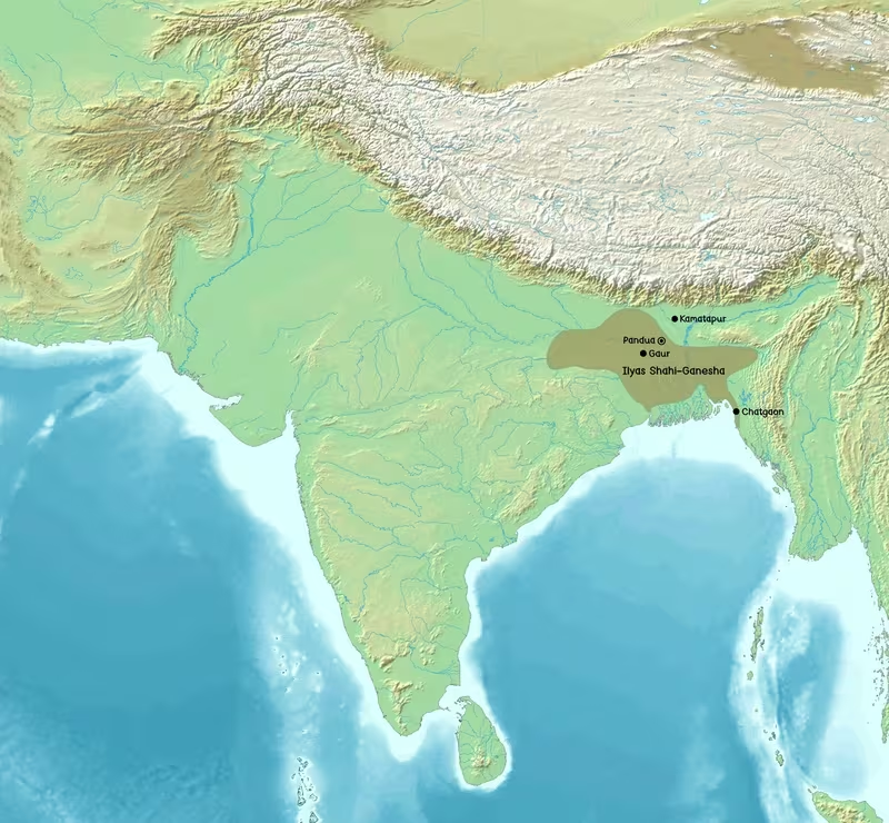
Bengal Sultanate at Its Hussain Shahi Zenith, c. 1498–1519 CE
Introduction
From the Ganges delta to the Brahmaputra Valley, the Bengal Sultanate’s power was shaped by rivers, ports, fertile plains, and shifting frontier alliances. During the reign of Alauddin Husain Shah, Bengali armies overthrew the Khen dynasty of Kamata, extended their authority towards Assam, restored control in Chittagong and northern Arakan, and maintained influence over Tripura, parts of Odisha, and territories west of Bengal. This map presents that eastern South Asian political world at the height of Hussain Shahi expansion.
The period represented here begins with Alauddin Husain Shah’s seizure of power in 1494 and focuses on the expansion associated with his reign, especially the conquest of Kamata in 1498 and the campaigns that followed. Husain Shah ruled until 1519, after which Nasiruddin Nasrat Shah continued the dynasty’s authority and pushed into Mithila in 1526. Because medieval political control varied between direct administration, tribute, military occupation, and temporary submission, the map uses separate visual categories for core territory, tributary states, and contested frontiers.
The Bengal Sultanate was not simply a land empire. Its capital cities and mint towns were tied to a dense network of rivers and waterways. Sonargaon connected Bengal with China, Southeast Asia, and the Middle East; Chittagong opened the sultanate to the Bay of Bengal; and Bengali merchants and ships travelled as far as Malacca, China, and the Maldives. The map therefore combines territorial geography with military campaigns, ports, river routes, and major urban centres.
Historical Context
From Delhi province to independent sultanate
Bengal was gradually absorbed into the Delhi Sultanate during the thirteenth century. Bakhtiyar Khalji’s conquest of Gauda in 1202–1204 marked the beginning of Turko-Afghan political ascendancy in the region. Delhi attempted to govern Bengal through appointed officials, but the distance between the two regions made sustained central control difficult. Governors repeatedly rebelled and established independent regimes.
In 1225, Sultan Iltutmish declared Bengal a province of Delhi. This arrangement remained unstable. Bengal’s riverine geography, seasonal climate, and distance from northern India made military intervention slow and difficult. Several provincial rulers—including Yuzbak Shah, Tughral Khan, and Shamsuddin Firoz Shah—exercised considerable independence. Shamsuddin Firoz Shah established a strong administration in eastern and southwestern Bengal and was associated with the conquest of Sylhet.
In 1325, the Delhi Sultanate reorganised Bengal into three administrative regions:
- Sonargaon, governing eastern Bengal;
- Gauda, governing northern Bengal;
- Satgaon, governing southern Bengal.
The arrangement did not last. By 1338, all three regions had separatist rulers: Fakhruddin Mubarak Shah in Sonargaon, Alauddin Ali Shah in Gauda, and Shamsuddin Ilyas Shah in Satgaon. Fakhruddin later conquered Chittagong in 1340. Shamsuddin Ilyas Shah defeated Alauddin Ali Shah and then overcame Ikhtiyaruddin of Sonargaon. By 1352, he had emerged victorious over the Bengali political triad.
The unification of the delta
Shamsuddin Ilyas Shah founded the Ilyas Shahi dynasty and unified the territories associated with the Ganges, Brahmaputra, and Meghna deltas. This was a decisive geographical development. Rather than treating Bengal as three separate zones centred on Gauda, Sonargaon, and Satgaon, Ilyas Shah brought the major deltaic regions into one sultanate.
His armies campaigned beyond the delta. They conquered eastern Bengal and northern Bihar, raided the Kathmandu Valley, and reached westward as far as Varanasi. His authority or military activity extended from Assam in the east towards Varanasi in the west, although the degree and duration of control varied between regions.
Delhi responded with military expeditions. In 1353, Firuz Shah Tughluq besieged Ekdala Fort. Bengal agreed to pay tribute, but Ilyas Shah retained firm control over the sultanate. Delhi invaded again in 1359 after the peace settlement collapsed. This time Bengali forces repulsed the invasion. A new treaty recognised Bengal’s independence, and the political separation from Delhi endured for roughly two centuries.
Pandua, Sonargaon, and Gaur
The early Ilyas Shahi rulers governed from Pandua. Sikandar Shah, the dynasty’s second ruler, built the Adina Mosque and successfully resisted the Delhi Sultanate during the second siege of Ekdala Fort in 1359. Ghiyasuddin Azam Shah later expanded Bengal’s diplomatic connections abroad and held court at Sonargaon as well as Pandua.
Sonargaon was particularly important because of its river port. Chinese envoys described it as a large metropolis, while the travel account of Ma Huan in 1406 referred to its urban scale and commercial connections. The port had shipping links to China, Southeast Asia, and the Middle East. Its location made it an economic and diplomatic bridge between the eastern delta and the wider Bay of Bengal.
In the fifteenth century, political instability led to the rise of Raja Ganesha, a powerful Hindu landholder. His son converted to Islam and took the throne as Jalaluddin Muhammad Shah in 1415. The House of Raja Ganesha was followed by the restoration of the Ilyas Shahi dynasty in 1432. Pandua remained a royal centre until Sultan Mahmud Shah moved the capital to Gaur in 1450, probably in response to changes in the course of nearby rivers.
Gaur became the principal capital during the period shown on this map. It remained the seat of the restored Ilyas Shahi rulers, the Abyssinian sultans, and the Hussain Shahi dynasty. Around 1500, Gaur was reputedly the fifth-most populous city in the world, after Beijing, Vijayanagara, Cairo, and Canton. The city had a citadel, royal palace, durbar, mosques, bazaars, canals, bridges, watchtowers, gateways, and fortified walls.
The Hussain Shahi accession
Alauddin Husain Shah came to power in 1494 and founded the Hussain Shahi dynasty. His accession ended a period of instability associated with the Abyssinian rulers who had controlled Bengal between 1487 and 1494. Husain Shah ruled until 1519. His dynasty continued until 1538.
The Hussain Shahi period is frequently described as a golden age of the Bengal Sultanate. Muslims and Hindus served together in the royal administration, and the state supported a form of religious pluralism. Persian remained the principal administrative, diplomatic, and commercial language, while Bengali received court recognition and developed as a major literary language.
Husain Shah’s reign was also marked by territorial expansion. His armies campaigned in Kamata and Assam, restored Bengali sovereignty in Chittagong and northern Arakan after the war of 1512–1516, exerted influence over Tripura and Pratapgarh, and pushed westward beyond Bihar towards Saran in the Jaunpur region. Coins proclaimed victories over Kamrupa, Kamata, Jajnagar, and Odisha.
Timeline of Expansion and Contraction
- 1202–1204 CE: Bakhtiyar Khalji conquers Gauda during the gradual incorporation of Bengal into the Delhi Sultanate.
- 1225 CE: Iltutmish declares Bengal a province of Delhi.
- 1325 CE: Bengal is reorganised into the regions of Sonargaon, Gauda, and Satgaon.
- 1338 CE: The three regions are ruled by separatist sultans.
- 1340 CE: Fakhruddin Mubarak Shah of Sonargaon conquers Chittagong.
- 1352 CE: Shamsuddin Ilyas Shah unifies the main Bengali political regions.
- 1353 CE: Firuz Shah Tughluq besieges Ekdala Fort; Bengal agrees to pay tribute.
- 1359 CE: Bengal defeats a renewed Delhi invasion, and a treaty recognises its independence.
- 1390–1411 CE: Ghiyasuddin Azam Shah strengthens relations with Ming China and holds court at Sonargaon.
- 1415–1420 CE: Bengal and Jaunpur fight; diplomatic intervention by Ming China and the Timurid ruler of Herat helps end the war.
- 1450 CE: Mahmud Shah shifts the capital from Pandua to Gaur.
- 1494 CE: Alauddin Husain Shah establishes the Hussain Shahi dynasty.
- 1498 CE: Bengali forces overthrow the Khen dynasty of Kamata.
- 1512–1516 CE: Bengal restores sovereignty in Chittagong and northern Arakan.
- 1519 CE: Alauddin Husain Shah’s reign ends; Nasiruddin Nasrat Shah succeeds him.
- 1526 CE: Nasrat Shah pushes into Mithila and annexes the ruling Oiniwar dynasty.
- 1538 CE: The Hussain Shahi dynasty ends; Bengal is drawn into the political struggles of the Sur Empire and the Mughals.
- 1564–1576 CE: The Karrani dynasty rules Bengal from Tanda.
- 1575 CE: Mughal victory at Tukaroi leads to the Treaty of Cuttack.
- 1576 CE: The Battle of Raj Mahal defeats the last reigning independent sultan of Bengal.
- Early seventeenth century: The Mughal state absorbs the Bhati delta, completing the suppression of the sultanate’s remaining political formations.
Territorial Extent and Boundaries
The core territory
The core of the Bengal Sultanate lay in the Ganges-Brahmaputra-Meghna delta and the adjoining plains of Bengal. This was the region most directly associated with the sultanate’s capitals, administrative institutions, mint towns, agricultural revenues, river fleets, and royal armies.
The sultanate’s political centre moved between several cities, but by the Hussain Shahi period Gaur was the principal royal capital. Sonargaon remained a major eastern centre, while Chittagong provided access to the Bay of Bengal. The map’s core territory therefore includes the main deltaic and lowland regions surrounding these centres.
The western limit varied over time. Ilyas Shah’s campaigns reached Varanasi, while the Hussain Shahi rulers extended Bengali territory beyond Bihar towards Saran in the Jaunpur region. These western zones were not necessarily governed with the same intensity as the central delta. Military reach, tribute, and temporary occupation should not be read as identical forms of sovereignty.
The northern frontier
The northern frontier ran towards Bihar, Mithila, Nepal, and the Himalayan foothills. Ilyas Shah conquered northern Bihar and led the first Muslim army into Nepal. His forces occupied Tirhut, dividing it into northern and southern parts. The southern section was retained by Ilyas Shah, while the northern part was restored to the Oiniwar ruler Raja Kameshwar.
From Tirhut, Ilyas Shah’s army advanced through the Terai plains into the Kathmandu Valley. The army sacked the temple of Swayambhunath and looted Kathmandu city for three days before returning to Bengal with booty. This campaign demonstrates the reach of Bengali military power, but it does not mean that the Kathmandu Valley became a permanent province of the Bengal Sultanate.
Under Nasiruddin Nasrat Shah, Bengali authority again expanded into Mithila. In 1526, the Oiniwar dynasty was annexed and its ruler Laksminathasimha was killed in battle. Since this event occurred after the principal date range of the map, it is best understood as a later extension of the Hussain Shahi sphere.
The western frontier
The western frontier faced Bihar, Jaunpur, and the wider political world of northern India. Bengal’s relations with Delhi alternated between war, tribute, and diplomatic recognition. The peace treaty of 1359 formally acknowledged Bengal’s independence, but later rulers continued to confront northern powers.
During the Jaunpur War of 1415–1420, the Jaunpur Sultanate challenged the House of Raja Ganesha. Bengal received diplomatic support from the Timurid ruler of Herat and the Ming emperor of China. These interventions helped bring the conflict to an end. The political result was the consolidation of the Bengali sultanate and the annexation of parts of Jaunpur’s territory.
During the Hussain Shahi period, the Lodi dynasty of Delhi attacked Bengal while pursuing the displaced Jaunpur ruler Hussain Shah Sharqi. The Delhi forces were unable to make headway and withdrew after a peace treaty. The episode shows that Bengal’s western boundary was not merely a fixed line; it was a zone of interaction involving Delhi, Jaunpur, Bihar, and the eastern Gangetic plain.
The eastern frontier
The eastern frontier reached into Assam and the Brahmaputra Valley. The campaign against Kamata was one of the defining achievements of Husain Shah’s reign. Bengali forces led by Shah Ismail Ghazi overthrew the Hindu Khen dynasty in 1498. King Nilambar was imprisoned, the capital was plundered, and Bengali authority extended to Hajo. The victory was commemorated in an inscription at Malda.
Earlier rulers had also campaigned eastward. Shamsuddin Ilyas Shah led an expedition against Kamarupa and captured Guwahati. Sikandar Shah later attacked Assam, though his campaign was weakened by a Delhi invasion of Bengal. Under the Habshi ruler Shamsuddin Muzaffar Shah, the Kamata Kingdom was defeated again in 1492–1493, and coins were issued bearing the phrase Kamata Mardan, or “destroyer of Kamata.”
The map marks the Assam frontier as partly contested because military success did not automatically create stable control across the entire Brahmaputra Valley. The later Gauda-Ahom War illustrates the difficulty of sustained eastern expansion. In 1532, Turbak invaded Ahom territory with cavalry, elephants, infantry, guns, and cannons. The Ahoms eventually defeated the invading army in a series of engagements, killing Turbak near the Bharali River and pursuing the retreating forces to the Karatoya.
The southeastern frontier
The southeastern frontier included Chittagong, the coastal routes of the Bay of Bengal, and Arakan. Chittagong was conquered by Fakhruddin Mubarak Shah in 1340. It later became a recurring point of conflict between Bengal and the Kingdom of Mrauk U.
The Bengal Sultanate supported the restoration of Min Saw Mon, a displaced Arakanese king. Bengali forces helped him regain the throne of his Launggyet dynasty, and Arakan became a vassal of Bengal. Arakanese rulers adopted elements of Bengali court culture, including the title of shah, coin designs, and administrative practices. The relationship was not permanent. Arakan later asserted its independence and became a powerful coastal kingdom.
Under Alauddin Husain Shah, Bengali sovereignty was restored in Chittagong and northern Arakan after the war of 1512–1516. Yet the frontier remained unstable. Arakanese rulers continued to contest Chittagong, sometimes in alliance with Portuguese pirates. This maritime rivalry makes the southeastern boundary especially difficult to represent as a single unbroken line.
The southern frontier
To the south, Bengal opened onto the Bay of Bengal and the Sundarbans. The delta’s waterways served as both communications routes and defensive spaces. The Sundarbans were not simply an empty frontier. Under Governor Khan Jahan Ali, settlement and administration expanded in the southwestern delta, including the mint town of Khalifatabad.
The southern sea frontier connected Bengal with the Maldives, Southeast Asia, China, and maritime polities along the Bay of Bengal. The coast was commercially productive but politically vulnerable. Ports could attract merchants, diplomatic envoys, pirates, and rival states at the same time.
Odisha and the southwest
Bengali military activity in Odisha began under Shamsuddin Ilyas Shah, who defeated Bhanudeva II of the Eastern Ganga dynasty, sacked Jajpur and Cuttack, and advanced as far as Chilika Lake. During the Hussain Shahi period, Shah Ismail Ghazi campaigned against the Gajapati ruler Kapilendra Deva and recovered Mandaran, where he built a fort.
The relationship between Bengal and Odisha changed repeatedly. At times, northern Odisha was directly ruled by Bengal; at other times, the region functioned as a tributary or contested zone. Under the Karrani dynasty, Odisha became the scene of the Battle of Tukaroi and the Treaty of Cuttack in 1575. These later developments reveal why the map distinguishes Bengali core territory from areas of military influence.
Tributary States and Direct Control
The Bengal Sultanate’s political geography included several kinds of relationship:
- Direct administration: Provinces and districts governed through officials, revenue arrangements, forts, and mint towns.
- Military occupation: Territory held after conquest but not necessarily integrated for a long period.
- Tributary submission: Local rulers retained authority while acknowledging the sultan and providing tribute.
- Vassalage: A neighbouring kingdom accepted Bengali suzerainty while maintaining its own ruling house.
- Contested frontier: Regions where control shifted between Bengal and a rival power.
Arakan, Tripura, Pratapgarh, and parts of Odisha often belonged to the wider political sphere of Bengal without becoming uniform provinces. Arakan was a prominent vassal for a period but later became independent. Tripura was important to Bengal for gold, silver, and mountain trade routes, and the Bengal Sultanate helped Ratna Manikya I assume the Tripuri throne in 1464. Pratapgarh’s ruler Bazid declared himself a sultan equal to the ruler of Bengal, prompting Husain Shah to send Sarwar Khan against him. Bazid was defeated, agreed to pay tribute, and surrendered his claim over Sylhet.
The map’s shaded frontier zones reflect these differences rather than suggesting that every region was governed from Gaur in the same way.
Administrative Structure
The Bengal Sultanate was an absolute monarchy influenced by Persianate political traditions. The sultan stood at the head of the royal household, military establishment, revenue system, and diplomatic apparatus. The court relied on the support of the ulama, or Islamic scholars, while government service was open to both Muslims and Hindus.
The administrative hierarchy included subdivisions known as arsa and iqlim, which were further divided into mahals, thanas, and qasbas. These terms indicate a layered system of territorial organisation, although the precise boundaries and functions of individual units changed over time.
Revenue administration remained connected to the agricultural wealth of Bengal. Fertile floodplains supported rice cultivation, sugarcane, sesame, fruits, vegetables, and other crops. Hindu zamindars controlled much agricultural land, creating tensions with Muslim taluqdars. The state therefore depended on cooperation and negotiation with local landed groups.
Capitals
The changing capitals reveal the relationship between political power and the river system:
- Pandua: Capital of the Ilyas Shahi rulers from 1342 to 1415 and of the House of Raja Ganesha from 1415 to 1433. It was a military, commercial, and architectural centre.
- Sonargaon: A major eastern capital and river port, especially associated with Ghiyasuddin Azam Shah. It maintained maritime links with China, Southeast Asia, and the Middle East.
- Gaur: Capital from 1433 to 1538 for the restored Ilyas Shahi, Abyssinian, and Hussain Shahi rulers. It was the principal political centre during the period represented by the map.
- Tanda: Capital of the Karrani dynasty from 1564, after the map’s main period.
Pandua’s bazaars sold fine cloth, wine, and other goods. Chinese envoy Ma Huan described its imposing walls, orderly shops, and abundance of merchandise. Gaur contained a citadel, royal palace, durbar, harem, mosques, canals, bridges, and defensive walls.
Mint towns
Mint towns were royal or provincial capitals where taka coins were struck. Their importance was both monetary and political. A mint established the authority of the sultan, supported commercial exchange, and encouraged the growth of an urban centre.
The Bengal Sultanate was particularly successful in maintaining a silver coinage. Silver taka coins could bear the names of the Bengali sultan and the contemporary Abbasid caliph in Cairo. Such inscriptions connected local sovereignty with the symbolic authority of the Sunni Islamic world.
The map treats mint towns as economic and administrative nodes rather than merely points on a political boundary. Their distribution reflects the expansion of the sultanate and the importance of regional centres across Bengal.
Infrastructure and Communications
Rivers as roads
In Bengal, rivers were central to communications. The Ganges, Brahmaputra, Meghna, Mahananda, Karatoya, Son, and numerous distributaries connected agricultural areas, capitals, forts, markets, and ports. River transport often offered a more reliable route than roads across flood-prone plains.
The navy was therefore essential to state power. War boats transported troops and supplies, patrolled rivers, collected tolls at ghats, and transported war elephants. The chief of the admiralty was responsible for shipbuilding, river transport, naval equipment, recruitment of sailors, and river patrols.
The military value of boats was seasonal. Cavalry could secure the country during the drier part of the year, while boats and infantry could dominate the waterways during the other half. This environmental rhythm shaped both warfare and administration.
Overland routes
The Grand Trunk Road connected Bengal with northern India, Central Asia, and the Middle East. It linked the eastern Gangetic plain to Delhi and other centres, while routes through Bihar and Jaunpur connected Bengal to the wider political world of northern India.
Road travel was particularly important for armies, diplomatic missions, merchants, and religious scholars. Yet the river system remained the defining communications network of the delta. A map of Bengal’s political geography must therefore read roads and rivers together.
Maritime connections
Bengal maintained maritime relations with states in the Indian Ocean and beyond. Bengali ships and merchants traded in:
- Malacca
- China
- The Maldives
- Southeast Asia
- The Middle East
- Portuguese India
- The Bay of Bengal coast
Sonargaon’s river port was linked to overseas shipping. Chittagong served as a major seaport and trading hub, though its position also made it vulnerable to Arakanese attacks and piracy. Bengali shipping coexisted with Chinese shipping in Southeast Asian waters until Chinese withdrawal from the Indian Ocean in the mid-fifteenth century.
Economic Geography
Agriculture and the delta
The Bengal Sultanate rested on the productive agriculture of the delta and adjoining plains. Rice formed the principal staple, while sesame, sugarcane, bananas, jackfruits, pomegranates, ginger, mustard, onions, garlic, and honey were among the region’s agricultural products.
Floodwaters could damage settlements and alter river courses, but they also renewed the soil. The shifting landscape influenced capital cities, trade routes, and administrative boundaries. The probable reason for the movement of the capital from Pandua to Gaur was a change in the course of nearby rivers.
The Sundarbans represented a different economic landscape. Its forests, waterways, and wetlands required distinct forms of settlement and administration. Khan Jahan Ali’s work in the southwestern delta included the development of Khalifatabad as a mint town.
Textiles and paper
Cotton textiles were among Bengal’s most important exports. The region was known for fine muslin, silk fabrics, rugs, veils, gauzes, embroidered silks, and turban materials. Chinese envoys recorded several types of muslin and other cloths, while European travellers described the large-scale export of cotton and silk goods.
Bengali textiles travelled across the Indian Ocean and overland through northern India, Central Asia, the Middle East, Arabia, Ethiopia, and other regions. The textile economy connected rural production to urban markets and seaports.
Paper was another specialised product. High-quality paper was made from the bark of mulberry trees around Pandua. Its lightness and whiteness were compared with fine muslin cloth. The combination of paper production, manuscript culture, and Persian literary patronage made cities such as Sonargaon important intellectual centres.
Coinage and exchange
Large transactions were conducted in silver taka. Smaller purchases used shell currency, especially cowry shells imported from the Maldives. One silver coin was described as equivalent to 10,250 cowry shells.
The predominance of silver coinage distinguished Bengal from several contemporary states. Tribute payments, military plunder, and inherited reserves provided sources of silver. Coin inscriptions also communicated sovereignty across the sultanate’s towns and markets.
Ports and entrepôts
Sonargaon and Chittagong were among the most important commercial centres. Sonargaon stood within the river network of eastern Bengal and maintained connections with China, Southeast Asia, and the Middle East. Chittagong faced the open Bay of Bengal and served as a port for maritime trade.
Gaur was the centre of regional politics and a major urban market. Pandua was an export centre for cloth and wine. Bagerhat, associated with Khalifatabad, was a major religious and urban development in the southwestern delta.
Bengal’s prosperity attracted merchants, immigrants, mercenaries, scholars, and religious figures from North India, the Middle East, Central Asia, and Africa. Persian migrants included teachers, lawyers, scholars, and clerics. Turks, Afghans, Arabs, and Abyssinians also entered Bengal’s political and military society.
Cultural and Religious Geography
Religious pluralism
The Bengal Sultanate was a Sunni Muslim monarchy, but its society included large Hindu communities and other religious traditions. Muslims and Hindus served jointly in the royal administration during the Hussain Shahi period. Hindu zamindars remained influential in agricultural society, while Muslim officials, scholars, merchants, soldiers, and landholders formed important parts of the state.
The political geography of Bengal was therefore not divided into separate religious territories. Mosques, Sufi institutions, Hindu settlements, markets, agricultural estates, and royal centres existed within the same landscapes.
Sufi networks
Sufi education and religious institutions were especially associated with Sonargaon. Institutions founded during the Delhi Sultanate continued under the Bengal Sultans. Scholars and preachers connected with the region included Ibrahim Danishmand, Saiyid Arif Billah, Muhammad Kamel, Saiyid Muhammad Yusuf, and others.
Bengal’s religious networks also reached beyond the subcontinent. Sultan Ghiyasuddin Azam Shah sponsored madrasas in Mecca and Medina. These institutions, known as the Ghiyasia Madrasa and Banjaliah Madrasa, connected Bengal’s court to the pilgrimage cities of the Hejaz.
Languages and literature
Persian was the official language of administration, diplomacy, and commerce. Arabic remained the liturgical language of the clergy and appeared in religious inscriptions and coin legends. Bengali was the main vernacular and received recognition at court under the sultans.
The Hussain Shahi period supported Bengali Muslim literature, Persian scholarship, Sufi writing, and Hindu literary production. The Dobhashi tradition combined Persian and Bengali vocabulary and developed poems and narratives based on Islamic themes. Bengali writers produced works concerning Yusuf and Zulaikha, Islamic cosmology, prophetic stories, and translations of Arabic and Persian literature.
Hindu poets of the period included Maladhar Basu, Bipradas Pipilai, and Vijay Gupta. Persian literary culture flourished particularly at Sonargaon, where Ghiyasuddin Azam Shah exchanged letters and poetry with the Persian poet Hafez.
Architecture
Bengal’s architecture combined Arab, Persian, Bengali, Indo-Turkish, and Byzantine influences with local building traditions. Brick was widely used, and terracotta decoration became a defining feature of many mosques. Sultanate architecture also developed distinctive curved roof forms later imitated in Mughal and Rajput buildings.
Common features of Bengal’s mosques included:
- Pointed arches;
- Multiple mihrabs;
- Engaged corner towers;
- Brick construction;
- Terracotta and stone decoration;
- Multiple domes or, in smaller buildings, a single dome;
- Ponds beside mosques.
The mosque city near the southwestern Sundarbans, associated with Khan Jahan Ali, is now recognised by UNESCO as a World Heritage Site. Other surviving or recorded buildings include the Adina Mosque at Pandua, the Kusumba Mosque, the Pathrail Mosque, the Shankarpasha Shahi Masjid, the Panbari Mosque in Assam, and the Santikan Mosque in former Arakan.
Royal mosques could include a raised throne known as a Badshah-e-Takht. The sultan used this elevated seat to address subjects, administer justice, and conduct government business. Mosques consequently served both religious and political functions.
Military Geography
The composition of the army
The Bengal Sultanate maintained an army containing cavalry, artillery, infantry, war elephants, and a navy. Cavalry was constrained by the regional environment. Horses had to be imported, and mounted troops could not operate with equal effectiveness throughout the year in a flooded and riverine landscape.
Infantry formed the vital core of Bengali military power. The paiks used bows, arrows, and guns and could operate alongside boats in the delta. Artillery included cannons and guns of different sizes. A Portuguese historian attributed Bengal’s military superiority over Arakan and Tripura partly to its efficient artillery.
War elephants carried military supplies and armed personnel. They were particularly useful for transporting equipment, although their movement was slow in riverine terrain. Boats compensated for the limitations of both elephants and cavalry by moving soldiers and supplies through the delta.
Forts and defensive positions
The sultans built permanent and temporary forts. Some were mud-walled structures adapted to the alluvial landscape. Ekdala Fort was a major defensive position during the Bengal–Delhi wars. Mandaran was fortified after Shah Ismail Ghazi recovered it during the campaign against the Gajapati Empire.
Gaur’s citadel and fortified palace complex formed the principal political and military centre in the Hussain Shahi period. Pandua had also developed from a small settlement into a military garrison and royal capital. River crossings, ghats, ports, and fortified towns were strategically important because control of movement was as significant as control of farmland.
Campaigns in Assam and Kamata
The conquest of Kamata was the most important eastern campaign associated with Husain Shah. Shah Ismail Ghazi led Bengali forces against the Khen dynasty. The campaign ended with the overthrow of King Nilambar, the plunder of the capital, and the annexation of territory extending towards Hajo.
The military road into Assam followed the Brahmaputra Valley and its tributaries. The region was difficult to control because of seasonal flooding, forests, river crossings, and the strength of local polities. Later Ahom resistance demonstrated that the initial conquest of a kingdom did not guarantee enduring Bengali rule over the entire valley.
Campaigns in Arakan and Chittagong
The coastal frontier required both land and naval power. Bengali forces helped Min Saw Mon regain Arakan after Burmese invasions, transforming Arakan into a vassal state. Later, the relationship deteriorated, and Arakan became an independent coastal power.
Chittagong remained the central strategic prize. It was economically valuable as a seaport and militarily important as the gateway between Bengal and Arakan. Bengali sovereignty was restored in Chittagong and northern Arakan during Husain Shah’s reign, but Arakanese rulers continued to contest the coast. Portuguese pirates allied with Arakanese forces, further complicating Bengali control.
Campaigns in Odisha
Bengali armies repeatedly entered Odisha. Ilyas Shah’s campaign reached Jajpur, Cuttack, and Chilika Lake. Shah Ismail Ghazi later recovered Mandaran from the Gajapati Empire. These campaigns brought plunder, elephants, and temporary territorial gains, but Odisha remained a frontier of changing alliances.
The later Karrani period saw the Battle of Tukaroi in 1575. Mughal troops under Akbar defeated Daud Khan Karrani’s army, and the Treaty of Cuttack followed. The final defeat came at Raj Mahal in 1576.
The river fleet
The navy was not an auxiliary institution but a central part of Bengali sovereignty. The admiralty organised shipbuilding, recruited seamen, fitted boats for transporting elephants, patrolled rivers, and collected tolls. Naval power allowed the sultanate to project force across the delta even when cavalry was ineffective.
The map’s river routes should therefore be read as military corridors as well as commercial paths. The same waterways carried rice, cloth, diplomats, troops, artillery, and royal officials.
Political Geography and Foreign Relations
Delhi and northern India
Relations with Delhi shifted between warfare and diplomacy. Bengal’s independence was recognised after the treaty of 1359, but Delhi continued to regard the eastern sultanate as a significant regional power. The Lodis later attacked Bengal while pursuing the Jaunpur ruler Hussain Shah Sharqi.
Bengal’s western diplomacy also involved the Jaunpur Sultanate. The war of 1415–1420 ended after intervention by the Timurid ruler of Herat and the Ming emperor of China. The episode reveals that the Bengal Sultanate was integrated into a wider diplomatic system extending across Central Asia and East Asia.
China and the Timurid world
Ghiyasuddin Azam Shah sent embassies to Ming China in 1405, 1408, and 1409. Chinese embassies visited Bengal between 1405 and 1433, including members of the fleets associated with Admiral Zheng He.
The exchange of diplomatic gifts included an East African giraffe sent by Sultan Shihabuddin Bayazid Shah to the Chinese emperor in 1414. Chinese records described Bengal as prosperous, civilised, and among the strongest states in China’s network of Asian contacts.
The Islamic world
The Bengal Sultans pledged nominal allegiance to the Abbasid caliphate in Cairo. Coins often carried the names of both the Bengali sultan and the contemporary Abbasid caliph. This relationship provided symbolic legitimacy among the Muslim clergy.
Bengal also maintained connections with the Hejaz. Ghiyasuddin Azam Shah sponsored madrasas in Mecca and Medina, while Egyptian rulers sent robes of honour and letters of recognition to Bengali sultans.
Southeast Asia and the Indian Ocean
Bengali ships and merchants participated in the trade of the Indian Ocean. Commercial and diplomatic links connected Bengal to Malacca, China, the Maldives, Brunei, Aceh, and other ports. A Bengali vessel was described as capable of carrying tribute missions from Bengal, Brunei, and Sumatra to China.
Bengal’s rice was exchanged for Maldivian cowry shells. Merchants from Pegu traded silver and gold with Bengalis. The coast thus formed part of an international commercial system in which currency, textiles, food grains, luxury goods, and diplomatic gifts circulated together.
Europe and Portuguese India
Portuguese visitors began arriving in Bengal after Vasco da Gama’s landing at Calicut. Portuguese merchants lived in Gaur, and the Sultan of Bengal permitted the establishment of a Portuguese settlement at Chittagong.
The Portuguese presence was not equivalent to Portuguese sovereignty. During the Iberian Union, there was no official Portuguese sovereignty over Chittagong. The trading post was affected by pirates allied with Arakanese forces against Bengal. This distinction is important when mapping European connections: Portuguese activity represented trade, settlement, and maritime conflict rather than formal colonial rule over the sultanate.
Reading the Map
The map uses a layered approach because the Bengal Sultanate’s political geography cannot be represented accurately by one solid colour.
Core areas
The core areas include the major deltaic and lowland territories associated with Gaur, Sonargaon, Pandua, Chittagong, and the administrative network of Bengal. These regions supplied the state with agricultural revenue, textiles, labour, ships, and silver currency.
Vassal areas
Arakan, Tripura, Pratapgarh, and parts of Odisha appear as vassal or tributary regions where appropriate. Their rulers often retained local authority. Bengali influence could involve tribute, dynastic intervention, military support, or recognition of the sultan’s suzerainty.
Campaign zones
Kamata, Assam, Mithila, Nepal, Arakan, Odisha, Jaunpur, and the western frontier are shown as campaign zones rather than uniformly administered provinces. Bengali armies could move across these regions, defeat rulers, take cities, and extract tribute without creating a permanent bureaucratic structure.
Maritime routes
The maritime layer places Bengal within the Bay of Bengal and Indian Ocean system. It emphasises Chittagong and Sonargaon, the Maldives connection, routes towards Malacca and China, and the movement of merchants and embassies. These networks explain why Bengal’s influence extended beyond the areas held by its armies.
Legacy and Decline
The Hussain Shahi period represented the high point of an independent Bengal Sultanate that had emerged from the failure of Delhi’s direct rule. Its rulers unified the great deltaic regions, developed capitals and mint towns, promoted trade, supported Persian and Bengali literary cultures, and projected military power into Assam, Arakan, Nepal, Bihar, Jaunpur, and Odisha.
The configuration shown here did not remain stable. After Husain Shah’s reign, Nasiruddin Nasrat Shah continued the dynasty’s authority and annexed Mithila in 1526. In 1538, the Hussain Shahi dynasty ended amid the wider expansion of the Sur Empire and Mughal intervention. Bengal regained independence under the Muhammad Shahi dynasty after a Sur governor rebelled, but this restoration was temporary.
The Karrani dynasty, of Afghan origin, became the last ruling house of the sultanate. Sulaiman Khan Karrani shifted the capital from Gaur to Tanda in 1565 and extended Bengali territory from Koch Bihar in the north to Puri in the south, and from the Son River in the west to the Brahmaputra in the east. Mughal pressure intensified. At Tukaroi in 1575, Akbar’s forces defeated Daud Khan Karrani, and the Treaty of Cuttack followed. The Battle of Raj Mahal in 1576 ended the rule of the last independent sultan of Bengal.
Mughal authority was not immediately complete. The Bhati region of the eastern delta remained outside Mughal control until the early seventeenth century. A confederation of twelve aristocrats, the Baro Bhuyans, preserved elements of the former sultanate’s political order. Their leader, Isa Khan, had been a nobleman of the sultanate through his mother, Princess Syeda Momena Khatun. The Mughal government eventually suppressed the confederation and brought all Bengal under Mughal control.
The Bengal Sultanate’s legacy survived in urban landscapes, mosques, tombs, coins, literary traditions, administrative practices, and maritime connections. Gaur, Pandua, Sonargaon, Bagerhat, and Chittagong remain essential to understanding the geography of medieval Bengal. Its architecture fused local Bengali forms with wider Islamic and Persianate traditions, while its commercial networks linked eastern South Asia to Africa, the Middle East, China, Southeast Asia, and Europe.
The map’s central lesson is that the Bengal Sultanate was both a territorial state and a networked riverine civilisation. Its authority moved through capitals, forts, ghats, waterways, ports, markets, diplomatic missions, and military expeditions. The strongest colours mark the heartland of Bengali rule; the softer zones represent tribute, alliance, or contested influence. Together, they show how power operated across one of medieval South Asia’s most fertile, prosperous, and geographically complex regions.