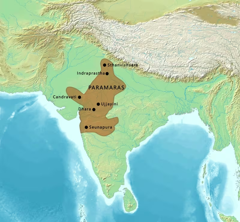
The Paramara Empire under Bhoja: A Map of Malwa at Its Zenith
Introduction
From the fortified and scholarly centre of Dhara, the Paramara ruler Bhoja presided over a kingdom whose reported limits reached from Chittor in the north to the upper Konkan in the south, and from the Sabarmati River in the west to Vidisha in the east. This is the broadest territorial frame associated with the Paramara dynasty, which ruled Malwa and neighbouring regions between the tenth and early fourteenth centuries.
The map captures the high point of a political tradition that had begun under the shadow of the Rashtrakutas. Siyaka, the earliest Paramara king securely attested by his own inscription, sacked Manyakheta around 972 CE. That victory contributed to the collapse of Rashtrakuta authority and established the Paramaras as an independent power in Malwa. His successors Munja and Sindhuraja expanded and defended the kingdom, while Bhoja transformed its court into a major centre of Sanskrit learning, architecture, and political prestige.
The boundaries shown here should be read as a maximum sphere of rule or influence rather than as a uniformly administered province. Medieval inscriptions and courtly accounts often celebrate victories, alliances, and submission, but they do not always distinguish between directly governed land, temporary conquest, tributary relationships, and claims made for political prestige.
Historical Context
From Rashtrakuta subordination to sovereignty
The Paramaras emerged in a political landscape shaped by the Rashtrakutas of Manyakheta, the Gurjara-Pratiharas, and regional powers in Gujarat, Rajasthan, the Deccan, and central India. The available evidence places the dynasty's early history in the ninth or tenth century, although the date at which the Paramaras first ruled Malwa cannot be fixed with certainty.
Between 808 and 812 CE, the Rashtrakutas expelled the Gurjara-Pratiharas from Malwa. Rashtrakuta authority in the region was exercised through subordinate rulers. An inscription of 871 CE records that a governor or vassal was appointed over Malwa. Some historians have proposed that this official may have been the early Paramara ruler Upendra, but the identification is not definitive.
The earliest surviving Paramara inscription is the Harsola copper-plate grant of Siyaka, dated 949 CE. It suggests that Siyaka had a relationship of subordination to the Rashtrakutas during part of his career. At the same time, his titles indicate considerable political ambition. The transition from feudatory status to sovereignty was marked by his campaign against the Rashtrakuta ruler Khottiga. After defeating the Rashtrakuta army on the banks of the Narmada, Siyaka pursued it to Manyakheta and sacked the capital around 972 CE.
This event is central to the map's historical background. Manyakheta lay far south of the Paramara core, but the attack had consequences in Malwa. The weakening of Rashtrakuta power allowed Siyaka to establish an independent kingdom centred on the Malwa region.
Munja and the consolidation of Malwa
Siyaka's successor Munja, also known as Vakpati II, strengthened the Paramara state. His campaigns are associated with victories against the Chahamanas of Shakambari and Naddula, the Guhilas of Mewar, Huna chiefs, the Kalachuris of Tripuri, and a ruler of the Gurjara region. The precise territorial consequences of each conflict are not always clear, but these campaigns reveal the strategic pressures surrounding Malwa.
Munja also fought the Western Chalukya ruler Tailapa II. Although he achieved early successes, he was eventually defeated and killed between 994 and 998 CE. The Paramaras consequently lost southern territories, probably including lands beyond the Narmada. This episode demonstrates that Paramara expansion was reversible and that the Narmada corridor was a contested frontier rather than a permanent imperial boundary.
Munja's reign was also important for the cultural geography of Malwa. Scholars were drawn to his court, and the ruler himself was remembered as a poet. Later Paramara claims to literary and intellectual prestige were therefore connected not only with Bhoja but with an established tradition of courtly patronage.
Sindhuraja and the recovery of southern territories
Sindhuraja, who succeeded Munja in the late tenth century, restored some of the territory lost during the Chalukya war. He defeated the Western Chalukya ruler Satyashraya and is associated with campaigns against a Huna chief, the Somavanshi ruler of south Kosala, the Shilaharas of the Konkan, and the ruler of Lata in southern Gujarat.
His court poet Padmagupta composed the Nava-Sahasanka-Charita, a literary biography that attributes many victories to Sindhuraja. Some of these claims may be poetic exaggerations. The text remains valuable for understanding how the Paramara court presented kingship, conquest, and the dynasty's place in the political world, but individual victories should not automatically be treated as evidence of lasting annexation.
Bhoja and the widest reported extent
Bhoja, the son of Sindhuraja, is the ruler most closely associated with Paramara power. His reign combined military initiatives with exceptional literary and architectural patronage. Around 1018 CE, he defeated the Chaulukyas of Lata in present-day Gujarat. Between 1018 and 1020 CE, he gained control of northern Konkan, where the Shilahara rulers probably served as his feudatories for a short period.
Bhoja also participated in an alliance against the Kalyani Chalukya ruler Jayasimha II. The alliance included Rajendra Chola and Gangeya-deva Kalachuri. The outcome is uncertain because both Chalukya and Paramara praise-poems claimed victory. This uncertainty is represented on the map by treating the southern and eastern zones as contested or influenced areas rather than as securely incorporated provinces.
During the later part of Bhoja's reign, after 1042 CE, the Kalyani Chalukya ruler Someshvara I invaded Malwa and sacked Dhara. Bhoja recovered control after the Chalukya army withdrew, but the invasion pushed the southern boundary of the kingdom back from the Godavari to the Narmada. The event illustrates the difference between the empire's maximum reach and the more limited territory it could hold consistently.
Territorial Extent and Boundaries
The Malwa core
Malwa was the heart of the Paramara kingdom. It occupies a plateau in west-central India, bounded by the Vindhyan highlands to the south and connected by river valleys and routes toward Gujarat, Rajasthan, and the upper Deccan. Dhara, identified with modern Dhar, served as the principal capital during the period of Paramara expansion.
The core territory should not be understood as a modern-style state with a surveyed line on every side. The political authority of a medieval dynasty normally varied by locality. Royal grants, inscriptions, subordinate chiefs, and military campaigns provide evidence of control, but the surviving record does not establish a single uniform boundary for every year of Bhoja's reign.
Northern frontier: Chittor and Mewar
Chittor marks the northern limit attributed to Bhoja's empire at its zenith. The region around Mewar was politically significant because of its position between Malwa, Rajasthan, and the routes leading toward northern India. Earlier Paramara campaigns had involved the Guhilas of Mewar, and the northern frontier remained connected to the wider rivalry among the Paramaras, Chahamanas, Guhilas, and other regional powers.
The map therefore presents Chittor as a reported northern extent, not necessarily as a permanently administered Paramara province. Military success in Mewar could produce tribute, alliance, or temporary occupation without creating lasting incorporation.
Southern frontier: the Narmada and the Konkan
The southern edge of Paramara power shifted repeatedly. Munja's defeat by Tailapa II caused the loss of territories beyond the Narmada. Sindhuraja later recovered some southern ground, while Bhoja extended influence into northern Konkan. The Konkan was not a simple continuation of the Malwa plateau: it was a coastal region with its own political authorities, including the Shilaharas.
Bhoja's northern Konkan expansion probably involved a period in which Shilahara rulers served as feudatories. This relationship is represented on the map as influence or subordinate rule rather than direct central administration. The Godavari represents an earlier or more ambitious southern reach associated with Bhoja's campaigns, while the Narmada became the effective southern limit after the Kalyani Chalukya invasion.
Western frontier: Gujarat and the Sabarmati
The Sabarmati River is identified as the western limit of Bhoja's empire at its reported height. Gujarat was both a neighbouring political zone and an early area of Paramara activity. Siyaka's earliest inscriptions were discovered in Gujarat and concern land grants there, although the reason for this geographic concentration remains debated.
Bhoja fought the Chaulukyas of Lata and gained victories in southern Gujarat around 1018 CE. These campaigns connected the Paramara kingdom to the Gujarat plains and to routes leading toward the Arabian Sea. Yet the repeated conflicts with the Chaulukyas show that western control was unstable. Gujarat cannot be treated as a permanently secured Paramara possession throughout Bhoja's reign.
Eastern frontier: Vidisha and the central Indian interior
Vidisha marks the eastern limit named for Bhoja's empire. Its location connected Malwa with the central Indian interior and with territories controlled or contested by the Chandelas and Kalachuris. Bhoja's eastward expansion was checked by the Chandela ruler Vidyadhara, although Bhoja extended influence among the Chandela feudatories known as the Kachchhapaghatas of Dubkund.
Bhoja also campaigned against the Kachchhapaghatas of Gwalior. These attacks may have been connected to a larger objective of capturing Kannauj, but they were repulsed by Kirtiraja. The eastern and north-eastern zones shown on the map should therefore be interpreted as areas of military competition and political influence rather than as consolidated Paramara territory.
Administrative Structure
The capital at Dhara
Dhara was the principal administrative and cultural centre of the Paramara kingdom. Under Munja and Bhoja, it functioned as the seat of royal power in Malwa and as a court that attracted poets, scholars, and intellectuals from different parts of India.
The surviving record does not provide a complete administrative survey of Bhoja's empire. It is therefore not possible to reconstruct a detailed set of provinces, district boundaries, tax registers, or a uniform bureaucratic hierarchy for the whole mapped area. The evidence instead reveals a layered political system in which the king ruled the Malwa core while relying on local chiefs, feudatories, allied rulers, and military authority in more distant areas.
Direct rule and feudatory relationships
The Paramara political structure included both direct rule and subordinate relationships. The Shilaharas of northern Konkan probably served Bhoja as feudatories for a brief period. Elsewhere, branches of the Paramara family ruled at places such as Vagada, where they governed from Arthuna as feudatories of the Paramara rulers of Malwa.
The Mahakumaras formed another branch connected with the dynasty. They ruled around the Bhopal region during a period when Malwa itself came under Chaulukya authority. These branches demonstrate that dynastic identity and territorial control did not always correspond to a single central administration.
The map's broad shaded extent therefore combines the Malwa heartland with regions where the Paramaras exercised military influence, received submission, or maintained dynastic relationships. It does not imply that every marked area was governed by officials appointed directly from Dhara.
Capital relocation to Mandu
Dhara was sacked several times by hostile powers. In the later period, either Jaitugi or Jayavarman II moved the capital to Mandapa-Durga, now Mandu. The hill site offered a stronger defensive position at a time when the kingdom faced attacks from the Yadavas of Devagiri, the Delhi Sultanate, the Vaghelas, and the Chahamanas of Ranthambhor.
The relocation reflects a major change in political geography. Dhara had represented the open plateau capital of an expansive Malwa kingdom; Mandu provided a more defensible centre for a reduced and increasingly threatened state.
Infrastructure and Communications
Roads and movement across Malwa
The historical record identifies the political centres, rivers, and military directions relevant to Paramara geography, but it does not preserve a complete road map or a documented postal system for Bhoja's empire. Any reconstruction of communications must therefore remain cautious.
Malwa's position made movement possible toward several neighbouring regions: Gujarat to the west, Rajasthan to the north-west, the central Indian interior to the east, and the Narmada valley and Deccan to the south. Campaigns by Siyaka, Munja, Sindhuraja, and Bhoja demonstrate that armies could move across these connected zones, but the surviving accounts do not specify the condition, length, or administrative maintenance of particular roads.
River corridors
The Narmada was one of the most important geographic features in Paramara military history. Siyaka defeated the Rashtrakuta ruler Khottiga on its banks before pursuing the retreating army southward. Later, the river became a reference point for the southern boundary of Malwa after Chalukya pressure.
The Sabarmati defined the western extent attributed to Bhoja, while the Godavari appears in accounts of the southern limit reached before the Chalukya recovery. These waterways served as geographic markers and likely aided movement, but the historical record does not document a formal river-based transport or communications administration.
Coastal connections
Bhoja's temporary control or influence in northern Konkan gave the Paramara kingdom access to a coastal region. However, no securely documented Paramara maritime system, fleet, or port administration is established in the available evidence. The map consequently shows the Konkan as an area of political influence rather than as proof of a centrally directed maritime empire.
Economic Geography
Malwa as the economic and political base
The Malwa plateau formed the principal territorial base of the dynasty. Its central position supported connections with Gujarat, Rajasthan, the Ganga-Yamuna hinterland, the Deccan, and the Konkan. The importance of Malwa to Paramara power is visible in the repeated efforts of neighbouring dynasties to capture Dhara or impose authority over the region.
The available accounts do not provide reliable figures for population, state revenue, agricultural production, or the size of the Paramara economy. Such estimates should not be inserted into the map without independent evidence.
Gujarat and Lata
The western region of Lata, in southern Gujarat, was a recurring zone of conflict. Sindhuraja campaigned against its ruler, and Bhoja defeated the Chaulukyas of Lata around 1018 CE. These struggles reflect the value of the corridor between Malwa and Gujarat, although the surviving narrative does not list specific commodities or quantify the revenues obtained.
The early concentration of Paramara inscriptions in Gujarat may indicate an early association with the region, but historians have proposed different explanations. The inscriptions themselves do not prove that Gujarat was the dynasty's original homeland.
The Konkan
The northern Konkan connected the Paramara sphere to the western coast. Bhoja gained control there between 1018 and 1020 CE, with the Shilahara rulers probably operating as feudatories for a short period. This was an important expansion in geographic terms, but it was not necessarily permanent. Later military reversals and the strength of regional coastal dynasties limited the durability of such claims.
Agricultural and resource zones
Malwa, the Narmada valley, Gujarat, and the Konkan contained different ecological and economic environments. The plateau and valleys supported the political core, while the coastal belt opened access to maritime networks. Nevertheless, the record used for this map does not identify a complete list of crops, mines, markets, toll stations, or commercial guilds. The economic layer should therefore be read as a reconstruction of regional connections, not as a detailed inventory.
Cultural and Religious Geography
Dhara as a Sanskrit centre
Paramara Malwa enjoyed considerable political and cultural prestige. Munja patronized scholars, and Bhoja became renowned as a scholar-king. Writers and intellectuals from different regions sought support at the Paramara court.
Bhoja's writings are associated with a wide range of subjects, including grammar, poetry, architecture, yoga, and chemistry. His reputation grew after his death, when later legends presented him as an ideal ruler comparable in fame to the legendary Vikramaditya. The map marks Dhara as a cultural centre because political authority and literary patronage were closely linked there.
Shaivism and religious patronage
Most Paramara kings were Shaivites and commissioned temples dedicated to Shiva. The dynasty also patronized Jain scholars, indicating that its religious geography was not exclusively sectarian. The available evidence points to a courtly environment in which Shaiva royal identity coexisted with support for Jain intellectual traditions.
Bhoj Shala and Sarasvati worship
Bhoja established the Bhoj Shala at Dhar as a centre for Sanskrit studies and associated it with a temple of Sarasvati. This institution represents the educational and intellectual dimension of his rule. It also illustrates the relationship between royal patronage, sacred space, and the public presentation of kingship.
Bhojpur and the Bhojeshwar Temple
The foundation of Bhojpur is attributed to Bhoja, and this belief is supported by historical evidence. The Bhojeshwar Temple, together with three now-breached dams in the surrounding area, is associated with his reign. Bhojpur is consequently marked as a cultural and architectural site, although the precise chronology and purpose of every associated work should be distinguished from later tradition.
Competing origin traditions
The Paramaras developed several accounts of their ancestry. Later rulers claimed descent from the Agnikula or Agnivansha, the “fire clan,” whose origin story places the creation of the dynastic hero at Mount Abu. The earliest known literary account of this legend appears in Padmagupta's Nava-sahasanka-charita, composed for Sindhuraja.
The legend is absent from earlier Paramara inscriptions and literary records. For this reason, it is generally treated as a later political and dynastic tradition rather than straightforward historical evidence. Other interpretations have connected the dynasty with Rashtrakuta ancestry, Brahmin origins from the Vashistha gotra, or a Kshatriya lineage. None of these explanations is universally accepted.
Military Geography
Malwa as a contested plateau
The Paramara kingdom occupied a central position among rival states. Its frontiers faced the Chaulukyas of Gujarat, the Western Chalukyas of Kalyani, the Kalachuris of Tripuri, the Chandelas of Jejakabhukti, the Chahamanas of Rajasthan, the Guhilas of Mewar, the Yadavas of Devagiri, and other regional powers.
This geography gave Malwa opportunities for expansion but also exposed it to invasions from several directions. The repeated sackings of Dhara show that the capital was reachable by hostile armies and difficult to protect when the kingdom's field forces were defeated or its alliances failed.
Siyaka's campaign against Manyakheta
Siyaka's attack on Manyakheta was the decisive military event in the dynasty's rise. After defeating the Rashtrakuta ruler Khottiga near the Narmada, he followed the retreating army deep into the Deccan and sacked the Rashtrakuta capital around 972 CE.
The campaign illustrates the offensive possibilities of a Malwa-based power. It also shows why the fall of a distant capital could change the political balance without creating permanent Paramara control over the Deccan. The significance of Manyakheta was political: its sack weakened the Rashtrakutas and enabled Paramara sovereignty in Malwa.
Munja and the western Deccan
Munja's campaigns ranged across Rajasthan, Malwa, Gujarat, and the Deccan frontier. His early successes against Tailapa II were followed by defeat and death. The resulting loss of southern territories demonstrates the vulnerability of a kingdom whose expansion crossed the Narmada.
The episode also influenced later Paramara political memory. Munja was remembered both as a warrior and as a patron of learning, combining the two ideals that shaped later representations of Paramara kingship.
Bhoja's campaigns
Bhoja's military geography was broad but uneven. His campaigns included:
- The defeat of the Chaulukyas of Lata in Gujarat around 1018 CE.
- The extension of influence into northern Konkan between 1018 and 1020 CE.
- Participation in an alliance against Jayasimha II of the Kalyani Chalukyas.
- Conflict with the Chandelas and their Kachchhapaghata feudatories.
- An unsuccessful campaign against the Kachchhapaghatas of Gwalior.
- A victory over the Chahamana ruler Viryarama of Shakambari.
- A retreat before the Chahamana ruler of Naddula.
The map distinguishes between victories that expanded Paramara influence and campaigns that ended in defeat or withdrawal. Bhoja's ability to project power over a wide area did not always result in lasting territorial annexation.
The Chalukya invasion of Dhara
After 1042 CE, Someshvara I of the Kalyani Chalukyas invaded Malwa and sacked Dhara. Bhoja restored control after the Chalukya army departed, but the invasion reduced the southern reach of the kingdom. The earlier boundary associated with the Godavari was replaced by the Narmada as the more practical southern limit.
This event is a key example of how the map's “zenith” differs from the political situation at the end of Bhoja's reign. A maximum territorial map captures the widest reported expansion, while a chronological map would show rapid contraction and recovery.
Later defensive geography
The Paramara kingdom continued to face pressure after Bhoja. Jayasimha I confronted a joint Kalachuri-Chaulukya invasion. Udayaditya resisted the Chaulukya ruler Karna with assistance from allies. Naravarman suffered defeats against the Chandelas and the Chaulukya ruler Jayasimha Siddharaja.
Dhara eventually fell to Jayasimha Siddharaja. Jayavarman I briefly recovered it, but an usurper named Ballala later controlled the capital. Around 1150 CE, Kumarapala of Gujarat defeated Ballala, and Malwa became a Chaulukya province. Paramara sovereignty was restored under Vindhyavarman, who defeated Mularaja II.
The later rulers inherited a much more difficult strategic environment. Yadava, Hoysala, Chaulukya, Vaghela, Chahamana, and Delhi Sultanate forces all affected the political geography of Malwa.
Political Geography
Relations with Gujarat
The Chaulukyas of Gujarat were among the most persistent western rivals of the Paramaras. Conflict focused on Lata, the Gujarat frontier, and the routes connecting Gujarat with Malwa. Bhoja's victories in southern Gujarat contributed to his wider reputation, but Chaulukya counterattacks repeatedly challenged Paramara authority.
The relationship was not limited to warfare. Feudatories, local chiefs, and branches of ruling families created overlapping political connections. Such relationships could change quickly when a major ruler died or when a capital was captured.
Relations with the Kalyani Chalukyas
The Western or Kalyani Chalukyas were the principal southern rival during the rise of Munja and the reign of Bhoja. Tailapa II defeated and killed Munja, while Someshvara I later invaded and sacked Dhara. Bhoja's alliance with Rajendra Chola and Gangeya-deva Kalachuri reflects the broader interstate politics of the Deccan and central India.
The outcome of Bhoja's alliance campaign against Jayasimha II remains uncertain. Royal panegyrics from both sides claimed success, making it difficult to draw a precise boundary from the event.
Relations with the Kalachuris
The Kalachuris of Tripuri were both enemies and, at moments, partners of the Paramaras. Munja fought them, while Bhoja allied with Gangeya-deva against the Kalyani Chalukyas. Later, Kalachuri and Chaulukya forces jointly attacked the Paramara kingdom after Bhoja's death.
This shifting relationship demonstrates that medieval political geography was shaped by temporary coalitions as much as by permanent dynastic rivalries.
Relations with the Chandelas and Kachchhapaghatas
The eastern frontier brought the Paramaras into conflict with the Chandelas of Jejakabhukti and their subordinate or associated Kachchhapaghata rulers. Bhoja's eastward expansion was checked by Vidyadhara, and an attack on Gwalior was repulsed.
The eastern frontier was therefore a zone of contested influence. Vidisha marks the broadest reported limit, but the military record does not support the idea of uninterrupted Paramara administration across all territory between Dhara and the eastern boundary.
The Delhi Sultanate
The Delhi Sultanate became increasingly important in the final phase of Paramara history. Iltutmish captured Bhilsa in 1233–1234 CE, although Devapala defeated the Sultanate governor and recovered the city. Later, the power of the Paramaras declined under pressure from Delhi, the Yadavas, and other neighbouring rulers.
Mahalakadeva, the last known Paramara king, was defeated and killed in 1305 CE by the forces of Alauddin Khalji. Epigraphic evidence indicates that Paramara rule may have continued for several years after his death. An inscription suggests survival in north-eastern Malwa until at least 1310, while a later record indicates that the area had been captured by the Delhi Sultanate by 1338.
Legacy and Decline
The contraction of the empire
The territorial configuration represented on this map did not last unchanged. Bhoja's empire depended on military success, alliances, and the temporary submission of neighbouring rulers. Defeat in the Deccan, pressure from Gujarat, attacks from the Chandelas, and the repeated targeting of Dhara gradually narrowed the territory under Paramara control.
After Bhoja, the dynasty experienced alternating recovery and decline. Some rulers regained Malwa after periods of Chaulukya control, but the kingdom was increasingly exposed to powerful regional states. The move from Dhara to Mandu reflected the need to defend a reduced realm rather than administer an expanding empire from an open plateau capital.
The final Paramaras
Jaitugideva and Jayavarman II faced attacks by the Yadavas, the Delhi Sultanate, and the Vaghelas. Arjunavarman II was weakened by ministerial rebellion, while later rulers endured raids from the Chahamanas of Ranthambhor and further Yadava intervention.
Mahalakadeva's defeat in 1305 marked the end of the dynasty's known sovereign power. The continuation of Paramara rule in parts of Malwa after his death shows that conquest was gradual rather than instantaneous. The dynasty's political legacy survived in regional branches and in later claims of descent.
Branches and later claims
Paramara branches ruled or claimed authority in several regions, including Chandravati, Bhinmal-Kiradu, Jalor, Vagada, and Bhojpur. Later families and princely states also claimed Paramara connections. These included the rulers of Garhwal, Baghal, Danta, Muli, Rajgarh, Narsinghgarh, Chhatarpur, Dewas, and Dhar.
Such claims belong to different periods and should not be projected backward onto the eleventh-century empire. They demonstrate the continuing prestige of the Paramara name, especially its association with Malwa, Ujjain, heroic ancestry, and Bhoja's memory.
Reading the Map
The central red zone represents Malwa and Dhara, where Paramara authority was strongest. The broader shaded area marks the maximum extent attributed to Bhoja: Chittor in the north, the upper Konkan in the south, the Sabarmati River in the west, and Vidisha in the east.
Several qualifications are essential:
- The boundary is approximate. Medieval inscriptions and court literature do not provide a modern surveyed frontier.
- Influence did not always mean annexation. Northern Konkan, for example, was probably connected to Bhoja through Shilahara feudatory relationships.
- Campaign claims may be exaggerated. Court poets and royal inscriptions often presented victories in idealised language.
- The zenith was temporary. The Kalyani Chalukya invasion after 1042 CE pushed the southern boundary back toward the Narmada.
- The dynasty's early history is debated. The identity of some early rulers and the dynasty's original homeland remain uncertain.
- Later branches should be separated from the imperial core. Paramara-descended or Paramara-claiming families continued in other regions long after the Malwa kingdom declined.
Conclusion
The Paramara map under Bhoja shows a kingdom built around Malwa but connected to a much wider political world. Dhara anchored the plateau core, while the Narmada, Sabarmati, Vindhyan highlands, Gujarat plains, Rajasthan frontier, central Indian interior, and Konkan coast shaped the possibilities and limits of expansion.
Bhoja's achievement lay in combining military projection with cultural authority. His kingdom reached its widest reported extent during a period of campaigns against Gujarat, the Konkan, Rajasthan, central India, and the Deccan. Yet its frontiers remained contested, and the same geography that enabled expansion made Malwa vulnerable to invasion.
The map is therefore not only a picture of territorial reach. It is also a study of political layers: a directly ruled heartland, feudatory regions, contested frontiers, temporary conquests, and cultural centres whose influence could outlast the boundaries of the kingdom itself.