Utpala Dynasty in Kashmir, c. 855–939 CE
Introduction
The Utpala political map begins in Kashmir around 855 CE, when Avantivarman displaced Utpalapida and claimed the throne with the support of the minister Sura. The new dynasty arose after years of violent succession struggles among members of the Karkota royal family and their powerful maternal relatives. Its effective heartland was Kashmir, while the extent of authority beyond the valley varied sharply from ruler to ruler.
This map therefore represents more than a fixed territorial block. It shows a Kashmiri kingdom whose political geography changed through royal coups, ministerial influence, military expeditions, and alliances with local groups such as the Damaras and Tantrins. During the period, Avantipura and Suyyapura were founded, major Shaiva and Vaishnava temples were built, and Buddhist monasteries continued to form part of the religious landscape. The dynasty ended in 939 CE, when Suravarman II was overthrown after only a few days on the throne.
The main literary account is Kalhana’s Rajatarangini, written in the 12th century and organized around the history of Kashmir. Its account of the Utpala period is indispensable but cannot be treated as a straightforward administrative survey. Modern discussion recognizes that the work combines political narrative, geography, social criticism, religious ideas, and literary construction. Its historical detail becomes stronger in the later books, yet individual descriptions, numbers, motives, and episodes remain matters for careful interpretation.
Historical Context
The Utpala Dynasty followed the decline of Karkota authority. After the death of Cippatajayapida, described as the last significant Karkota king, around 840 CE, rival factions competed for control. Padma, Utpala, Kalyana, Mamma, and Dharma fought for influence, while short-lived rulers from the Karkota lineage were installed and removed. These puppet kings did not restore political stability.
Tribhuvanapida’s son Ajitapida was first nominated by Utpala. Mamma later defeated Utpala and installed Anangipida. Utpala’s son Sukhavarman then rebelled and placed Utpalapida, a son of Ajitapida, on the throne. Sukhavarman attempted to become king himself but was murdered by a relative. His son Avantivarman eventually deposed Utpalapida and became king around 855 or 856 CE.
Avantivarman ruled for approximately 27 years, until 883 CE. The Rajatarangini records no military activity during his reign and states that frontier territories remained outside Kashmir’s sovereignty. His reign is instead associated with internal consolidation, irrigation, water management, town foundations, temples, and literary patronage. His minister Suyya is credited with important innovations in the management of water, a significant concern in a mountain valley exposed both to agricultural demands and destructive flooding.
The succession after Avantivarman was less stable. Ratnavardhana, the chamberlain, initially placed Sankaravarman at the centre of affairs, while the counsellor Karnapa supported Sukhavarman. Several battles followed before Sankaravarman prevailed. His reign combined external campaigning and economic prosperity in its earlier phase with severe fiscal oppression later.
Sankaravarman’s reported campaign toward Gujarat is one of the most striking military episodes on the map. Kalhana gives an enormous army figure of nine hundred thousand infantry, one hundred thousand cavalry, and three hundred elephants. Such figures should be read cautiously as literary or rhetorical numbers rather than as a secure census of military strength. The local ruler Alakhana reportedly surrendered territory or made a substantial gift in order to preserve his sovereignty.
After Sankaravarman died in 902 CE from a stray arrow while returning from a successful conquest in foreign territory, the kingdom entered a prolonged period of rapid succession. Gopalavarman ruled from 902 to 904 CE under the regency of his mother Sugandha. He led an expedition against a rebel Hindu Shahi ruler of Udabhanda around 903 CE. Gopalavarman’s death, reportedly arranged through witchcraft and assassination, was followed by the brief accession of his brother Samkata.
Sugandha then ruled in her own right for approximately two years. She sought to secure the throne for her grandson, but the child died soon after birth. Her attempt to install Nirjitavarman met resistance from ministers and the Tantrins, who preferred his child Partha. This began another cycle of regency, factional control, and disputed succession.
Partha ruled from 906 to 921 CE under Nirjitavarman’s regency. During this period, ministers and Tantrins were accused of extracting heavy bribes and plundering royal finances. A flood in 917 CE was followed, according to Kalhana, by a devastating famine. Hoarded rice was allegedly sold at high prices, turning environmental crisis into political and economic exploitation.
The throne changed hands repeatedly after Partha’s overthrow. Cakravarman, Suravarman I, Partha again, and the minister Sambhuvardhana each became involved in the struggle. In 936 CE, Cakravarman allied with the Damaras under Samgrama. Their forces defeated Sambhuvardhana near Padmapura, identified with modern Pampore. Cakravarman was restored after a victory procession through the city, but his later rule was marked by violence and court controversy. Damara guards eventually attacked and killed him in 937 CE.
Unmattavanti followed Cakravarman and ruled in an atmosphere of violence and ministerial domination. Parvagupta, who desired the throne, became the effective power behind the king. Unmattavanti died of chronic illness in 939 CE. Suravarman II was proclaimed king but was removed after only a few days by the commander Kamalvardhana, who rebelled from Madavarajya. Suravarman II and his mother fled, bringing the Utpala Dynasty to an end.
Territorial Extent and Boundaries
The secure political core shown on this map is Kashmir. The kingdom’s precise outer boundaries cannot be reconstructed with confidence from the surviving narrative. Avantivarman’s reign is especially important in this respect: the Rajatarangini records no military activity and explicitly indicates that frontier territories remained outside Kashmir’s sovereignty.
The northern and eastern edges of the kingdom were shaped by the surrounding Himalayan mountain system. These ranges formed formidable geographic barriers but also contained passes and corridors through which armies, political influence, and cultural connections could move. The map should not be read as showing a single surveyed frontier running along every mountain crest. Rather, it represents a valley-centred polity whose control beyond the central region could be intermittent.
The western and northwestern political horizon included areas associated with the Hindu Shahis. Gopalavarman’s expedition against a rebel ruler of Udabhanda around 903 CE demonstrates that the Utpala court could project military force beyond Kashmir. It does not, however, prove the establishment of a permanent Utpala province there. The exact location of Udabhanda and the full extent of the campaign remain subjects requiring caution.
Sankaravarman’s reported invasion of Gujarat similarly reveals military reach rather than a clearly documented permanent annexation. The account states that Alakhana, the local ruler, gave territory to preserve his sovereignty. This suggests coercive pressure and negotiated submission, but the surviving account does not define the size, location, or administrative status of the territory involved.
The southern frontier was connected to the wider northwestern and northern Indian political world through mountain routes and adjacent territories. Yet no continuous boundary, tributary list, or provincial register survives for the Utpala kingdom. The map consequently distinguishes the Kashmiri core from campaign zones and uncertain areas of influence.
Administrative Structure
The Utpala state was a monarchy centred on the Kashmiri court. Kingship, however, was repeatedly shaped by chamberlains, ministers, counsellors, treasurers, military commanders, royal women, Tantrins, and Damaras. The succession crises show that the political geography of the kingdom depended not only on territory but also on control of the capital and access to the royal person.
Avantivarman ruled with the assistance of ministers including Sura and Suyya. Suyya’s water-management works suggest that royal authority operated through practical interventions in agriculture and settlement. Avantivarman also commissioned towns and temples, linking political legitimacy to the organization of inhabited space and religious patronage.
Under Sankaravarman, the fiscal administration expanded. New revenue offices were created, an elaborate taxation system was developed, and numerous Kayasthas entered royal service. Kalhana presents this process negatively, accusing the administration of impoverishing villagers and placing religious endowments and agraharas under direct royal control. Forced labour was reportedly legalized and refusal to perform such service became an offence.
These descriptions should be understood as part of Kalhana’s moral and political criticism as well as evidence for administrative change. They indicate a monarchy attempting to increase its fiscal reach, but they do not provide a complete map of districts or offices. No securely documented list of provinces, governors, or standardized administrative boundaries survives for the dynasty.
The capital itself is not consistently identified through a formal administrative description in the available account. Kashmir functioned as the central political space, while named towns such as Avantipura, Suyyapura, Samkarapura, Sugandhapura, and Gopalapura demonstrate royal investment in settlement and religious geography.
Infrastructure and Communications
The clearest infrastructure associated with the Utpala period is water management. Suyya, serving under Avantivarman, is credited with innovations in irrigation and the control of water. These works were central to agriculture and settlement in Kashmir, where floods could produce catastrophic consequences. The flood and famine of 917 CE, described during the reign of Partha, underline the political importance of controlling water and food supplies.
The dynasty’s town foundations also represent infrastructure and state formation. Avantipura and Suyyapura were not merely names on a political map; they were centres associated with royal or ministerial building activity. Samkarapura was established under Sankaravarman, while Sugandhapura and Gopalapura were linked to Sugandha. These settlements connected royal patronage with the organization of urban and religious space.
No securely described road system, postal service, or maritime network is recorded for the Utpala kingdom. The map therefore does not draw continuous trade roads or communication lines as established fact. Military expeditions toward Gujarat and Udabhanda, and the movement of forces between Kashmir and Padmapura, demonstrate that armies could traverse the surrounding region, but the exact routes are not preserved.
Economic Geography
Agriculture formed an important foundation of the kingdom, particularly because irrigation and water control received attention under Avantivarman. The creation of revenue offices and the extension of taxation under Sankaravarman indicate an effort to draw greater resources from cultivators and local institutions.
The economic history of the period is also marked by conflict over fiscal extraction. Kalhana portrays Sankaravarman as seizing temple revenues, plundering religious institutions, and bringing agraharas under closer royal control while offering limited compensation. During the later succession struggles, ministers and Tantrins were accused of profiting from the royal treasury and from the sale of stored rice during the famine following the flood of 917 CE.
No reliable catalogue of commodities, markets, ports, or long-distance trade routes is available in the historical account used for this map. Gujarat appears as a campaign destination rather than as a documented Utpala commercial possession. Likewise, no maritime capability or coastal territory is established. The economic map should therefore focus on the Kashmiri agrarian base, water-management works, fiscal institutions, temples, and towns rather than on unsupported trade networks.
Cultural and Religious Geography
Utpala Kashmir supported a diverse religious landscape. Avantivarman was personally devoted to Vishnu but publicly patronized Shiva. Vaikuntha Chaturmurti continued as the dynasty’s tutelary deity and was venerated in adjoining regions. This combination of personal devotion, public patronage, and dynastic cult illustrates the importance of religious geography to Utpala kingship.
Avantivarman and his chief minister Sura commissioned temples and towns at Avantipura. The Avantiswami Temple represented Vaishnava patronage, while the Avantiswara Temple was dedicated to Shiva. The same period also saw the construction of Buddhist monasteries, indicating that the religious landscape was not exclusively Shaiva or Vaishnava.
Sankaravarman and Sugandha were associated with the Shiva temples of Samkaragaurisa and Sugandhesa. A further Shiva temple at Fattegarh has been dated to Sankaravarman’s period. Sugandha was linked to Sugandhapura, Gopalapura, the Vishnu temple Gopalakesava, and the monastery Gopalamatha. Nanda consecrated the shrines of Nandakesava and Nandamatha, while Meruvardhana built the Vishnu shrine of Meruvardhanasvamin at Puranadhisthana, identified with modern Pandrethan. Sambavati was associated with the Shiva shrine of Sambveswara.
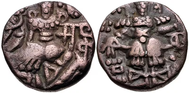
The court of Avantivarman was also a literary centre. Ratnakara and Anandavardhana are identified as court poets. The survival of coins issued by all the major Utpala rulers provides additional evidence for dynastic authority, although the available account does not specify the mints or circulation zones of these coins.
Military Geography
Utpala military geography was shaped by Kashmir’s valley setting, its mountain approaches, and the concentration of political power around the court. Avantivarman’s reign is notable for the absence of recorded military activity. His frontiers remained beyond Kashmir’s sovereignty, suggesting a period in which internal consolidation and hydraulic works were more prominent than expansion.
Sankaravarman altered this pattern. His reported campaign toward Gujarat indicates an ability to mobilize a large army and project power beyond the immediate Kashmiri region. The figures given by Kalhana—nine hundred thousand infantry, one hundred thousand cavalry, and three hundred elephants—are extraordinarily large and should not be treated uncritically as verified troop totals.
Gopalavarman’s expedition against the Hindu Shahi ruler of Udabhanda around 903 CE marks another outward campaign. The king reportedly distributed the spoils to a figure called Toramana-Kamaluka. The account suggests victory and prestige but does not establish lasting Utpala control over the defeated ruler’s territory.
The most clearly localized battle on the map occurred near Padmapura, modern Pampore, in spring 936 CE. Cakravarman and the Damara leader Samgrama defeated Sambhuvardhana. The battle was decisive because Samkaravardhana, who commanded for the Tantrins, was killed by Cakravarman. Cakravarman then returned to the throne in a victory procession.
The alliance with the Damaras later broke down. In 937 CE, Damara guards attacked Cakravarman at night and killed him. This episode shows that military groups and regional elites could determine the fate of the monarchy itself. By 939 CE, Kamalvardhana’s rebellion from Madavarajya ended the dynasty.
Political Geography
Utpala political geography was dominated by unstable relationships between the king and powerful internal groups. Ministers could nominate or depose rulers, royal women could govern as regents or sovereigns, and the Tantrins could determine access to the throne. The Damaras were both military allies and later enemies.
The dynasty’s relationship with neighbouring polities was similarly variable. Avantivarman did not extend sovereignty over the frontier territories mentioned in the narrative. Sankaravarman’s campaign toward Gujarat brought pressure on Alakhana, but the arrangement appears to have involved the preservation of local sovereignty rather than direct annexation. Gopalavarman’s attack on Udabhanda also demonstrates conflict with a Hindu Shahi ruler without proving permanent occupation.
The map therefore separates direct Kashmiri rule from military reach, negotiated submission, and contested influence. It does not portray Gujarat or Udabhanda as ordinary Utpala provinces.
Legacy and Decline
The Utpala Dynasty lasted from Avantivarman’s accession around 855 CE until the flight of Suravarman II in 939 CE. Its political history moved from the stabilization and construction associated with Avantivarman to the fiscal centralization and campaigns of Sankaravarman, followed by repeated coups and competing claimants.
Its most enduring material legacy lies in settlement, water management, temple construction, monasteries, shrines, literature, and coinage. Avantipura, Suyyapura, Samkarapura, and the associated religious foundations preserve the imprint of royal and ministerial patronage across the Kashmiri landscape.
The dynasty’s collapse resulted from more than a single military defeat. Repeated child successions, ministerial rivalry, Tantrin intervention, Damara resistance, fiscal exploitation, famine, and commanders’ rebellions progressively weakened royal authority. After Kamalvardhana rejected his own nomination and helped produce the selection of Yasaskara, the Utpala line ended. Later political developments prepared the way for the rise of the Lohara Dynasty, associated with Samgramaraja, the son of Didda’s brother.
This map should therefore be read as a layered reconstruction: a Kashmiri dynastic core, a network of royal foundations, and a series of external campaign zones whose precise boundaries remain uncertain.