Overview
Between the Kaveri and Arasalar rivers, Kumbakonam developed as a city where political history, temple traditions, agriculture, education, and craft production came together. Located in Tamil Nadu's Thanjavur district, it lies about 40 kilometres from Thanjavur, 96 kilometres east of Tiruchirappalli, and 282 kilometres south of Chennai. The surrounding Kaveri delta gave the city fertile agricultural land, while its temples and religious institutions drew pilgrims, scholars, artisans, and patrons across many centuries.
Kumbakonam is associated with the Sangam-period settlement of Kudavayil and with the political world of the early Cholas. Its wider region became especially important under the medieval Cholas, while nearby Pazhaiyaarai served as a Chola capital in the ninth century. Later, Pandyas, Vijayanagara rulers, the Madurai and Thanjavur Nayaks, the Thanjavur Marathas, and the British East India Company successively shaped its political and cultural life.
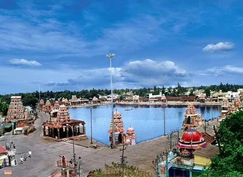
The city is popularly known as a temple town because of its concentration of Hindu shrines. Approximately 188 Hindu temples stand within the municipal limits, with further important shrines in the surrounding taluk. The twelve-yearly Mahamaham festival, held around the Mahamaham tank, gives Kumbakonam a pilgrimage importance that extends far beyond the region. Yet its history is not only religious. Kumbakonam became a centre of Vedic learning, Western education, Tamil scholarship, silk weaving, metalwork, banking, and regional commerce.
Etymology and Names
The name Kumbakonam is generally translated as “Pot’s Corner.” It refers to the mythical kumbha, or pot, associated with Brahma, the Hindu creator god. According to the local tradition, this vessel contained the seeds of all living beings. During a pralaya, or cosmic dissolution, the pot was displaced and eventually came to rest at the site of the present city. The tradition is commemorated through the Mahamaham festival, when pilgrims gather at the Mahamaham tank once every twelve years.
The city has been known by several names. Classical texts and historical records refer to it as Baskarashetram, Kumbam, and Kudanthai. In Tamil, it was formerly known as Kudamukku. Kumbakonam is also identified with Kudavayil, a settlement associated with the Sangam period. Colonial records commonly rendered the name as “Coombaconum.”
These names reveal the different layers through which the city has been remembered: an ancient Tamil settlement, a place of sacred geography, and a town recorded in colonial administrative writing. The modern name has become dominant, but Kudanthai remains widely used in Tamil cultural and religious contexts.
Geography and Location
Kumbakonam stands at an average elevation of about 26 metres. The Kaveri forms its northern boundary and the Arasalar its southern boundary. The city is situated in the Old delta region of Thanjavur district, where the northwestern parts of the district were naturally irrigated by the Kaveri and its tributaries. This setting distinguishes the area from the New delta, whose agricultural development depended on later canal systems, including the Grand Anicut canal and the Vadavar canal network.
The city is surrounded by paddy fields and lies within a landscape shaped by irrigation. Alluvial and black soils support rice cultivation as well as mulberry, cereals, and sugarcane. Betel leaves and areca nuts are important products of the rural areas around Kumbakonam. Agriculture has therefore been more than a background activity: it supplied food, supported processing industries, and connected the city to the prosperity of the Kaveri delta.
Kumbakonam's geological setting is also distinctive. It lies on the western flank of the Kumbakonam–Shiyali ridge, which follows the Kollidam River basin. The ridge separates the Ariyalur–Puducherry depression from the Nagapattinam depression and continues eastward beneath the Puducherry depression. Beneath the sedimentary topsoil, it forms a subterranean layer of Cretaceous rock.
The climate is tropical. Summer temperatures reach approximately 40°C, while winter minimums are around 20°C. The city receives an average annual rainfall of 114.78 centimetres. Its location within an irrigated delta, rather than on a defensible hill or coast, helped make it a productive agricultural and settlement centre. Its later importance came from the interaction of this fertile setting with river crossings, regional roads, pilgrimage routes, and railways.
Ancient History
The region around Kumbakonam was inhabited during the Sangam period, conventionally dated from about 300 BCE to 300 CE. The present city is associated with Kudavayil, an ancient settlement where the early Chola king Karikala is said to have held court. This association places Kumbakonam within the early political geography of the Chola country.
Some historical interpretations also connect the city with Kudavayir-kottam, described as the prison where the Chera king Kanaikkal Irumporai was held by the early Chola ruler Kocengannan. The identification is not entirely certain, and the surviving historical record does not settle every aspect of the relationship between these names and the modern city. Kumbakonam is also linked with Malaikūrram, which served as a Chola capital in the seventh century, and with Solamaligai, another nearby Chola seat.
These traditions indicate that the area was not simply an agricultural settlement. It belonged to a wider network of royal courts, capitals, temples, and fortified or administrative places in the Kaveri basin. Its political importance increased as Chola power developed, but its sacred importance also grew through the temples and ritual landscapes that later defined the city.
An important ninth-century conflict is recorded in the Sinnamanur plates. In 859 CE, the Pandya king Srimara Srivallabha defeated a confederacy of Pallavas, Cholas, and Western Gangas in a battle associated with Kumbakonam. The event reflects the strategic significance of the Kaveri region, where competing dynasties sought control over fertile territory and established political centres.
Historical Timeline
Medieval Chola Era
Kumbakonam and the surrounding region grew in political importance under the medieval Cholas between the ninth and twelfth centuries. The nearby town of Pazhaiyaarai, approximately eight kilometres away, functioned as a Chola capital during the ninth century. This proximity placed Kumbakonam within a royal landscape that included courts, temples, residences, and administrative institutions.
The Chola period also left a durable architectural and religious imprint on the region. The Adi Kumbeswarar Temple is described as the city's oldest Shaivaite shrine, with origins in the seventh-century Chola period. The Nageswaraswamy and Kasi Viswanathar temples are connected with the seventh- and eighth-century Tevaram canon, a major body of Tamil Shaiva devotional poetry. These associations contributed to the city's later identity as a centre of temple worship and Tamil religious culture.
The Chola legacy continued beyond the immediate city. At nearby Darasuram stands the Airavatesvara Temple, built in the twelfth century by Rajaraja Chola II, who ruled from 1146 to 1173. The temple is recognised as a UNESCO World Heritage Site together with the other Great Living Chola Temples. Its location only three kilometres from Kumbakonam makes the city an important base for encountering the wider architectural heritage of the Chola delta.
Pandya, Vijayanagara, and Nayak Rule
Following the decline of Chola power, the Pandyas took control of Kumbakonam in 1290. In the fourteenth century, after Pandya power weakened, the city was conquered by the Vijayanagara Empire. The transition formed part of a wider rearrangement of political authority in southern India.
The Vijayanagara emperor Krishnadevaraya visited Kumbakonam in 1524. During this visit, he bathed in the Mahamaham tank during the Mahamaham festival. His presence connects the city's local pilgrimage traditions with the authority and patronage of one of the most prominent rulers of the Vijayanagara period.
After 1565, when the Vijayanagara Empire declined, Kumbakonam experienced an influx of poets, musicians, and scholars. This movement influenced the region's demographic and cultural character. The city was later ruled by the Madurai and Thanjavur Nayaks from 1535 until 1673. Their period is especially visible in the city's temple architecture, patronage networks, and market development.
The Ramaswamy Temple, for example, was built by Govinda Dikshitar, who served as prime minister to the Thanjavur Nayak rulers Achuthappa Nayak and Raghunatha Nayak. Dikshitar also laid out Chinna Kadai Veethi, a market corridor connecting the Ramaswamy and Chakrapani temples. In this way, religious buildings and commercial streets formed part of a single urban plan.
In 1673, the Thanjavur Marathas annexed Kumbakonam. The city continued to function within a cultural environment shaped by Tamil, Sanskrit, Marathi, and regional traditions. The Kanch Kamakoti Peetham was temporarily based at Kumbakonam in the 1780s, following the invasion of Kanchipuram by Hyder Ali or Mysore, according to the records of the Kanchi matha. The relocation strengthened the city's role as a centre of monastic and religious activity.
Conflict, Company Rule, and Colonial Expansion
Tipu Sultan's invasion of the region in 1784 caused substantial economic disruption and agricultural losses. Kumbakonam took until the early nineteenth century to recover. This episode demonstrates how military campaigns affected not only forts and royal capitals but also irrigated agricultural towns whose economy depended on stable cultivation and trade.
In 1799, the Thanjavur Maratha ruler Serfoji II ceded Kumbakonam to the British East India Company. The town then became part of the administrative and commercial structure of the Madras Presidency. The Tanjore district court was established at Kumbakonam in 1806 and operated there until 1863.
The nineteenth century brought new transport and educational connections. The opening of the Suez Canal in 1869 expanded trade links with Britain, while a railway line opened in 1877 connected Kumbakonam with Madras, Tuticorin, and Nagapattinam. These links strengthened the city's regional commercial role and made it more accessible to students, officials, merchants, pilgrims, and scholars.
By the late nineteenth and early twentieth centuries, Kumbakonam had become a leading regional centre for Vedic scholarship, Hindu religious institutions, and Western-style education. This combination led to the nickname “Cambridge of South India.” The comparison referred to the city's educational and intellectual reputation rather than to a formal institutional connection with Cambridge.
Post-Independence and Modern History
Kumbakonam continued to expand after Indian independence, although its population and administrative growth lagged behind neighbouring Thanjavur. Population growth declined noticeably after 1981. This has been attributed to geographical limits on expansion and limited industrial development, even though census figures show continuing growth in peripheral areas.
Modern Kumbakonam has also experienced serious public tragedies. During the 1992 Mahamaham festival, a stampede caused 48 deaths and 74 injuries. On 16 July 2004, a fire at the Sri Krishna school killed 94 children. These events remain part of the city's modern social history and underline the importance of public safety in a densely visited pilgrimage and educational centre.
The municipality was upgraded to a municipal corporation on 24 August 2021. It now comprises 48 wards and has an expanded administrative jurisdiction of 42.9 square kilometres.
Political Significance
Kumbakonam's political significance has changed over time. In the early historical period, it was associated with the court of Karikala and the ancient settlement of Kudavayil. In the medieval period, it belonged to a zone of Chola capitals and royal institutions. The battle recorded for 859 CE further indicates the importance of the area to competing dynasties.
Its later political role was less that of an imperial capital and more that of an administrative and regional centre. The Tanjore district court operated in the town from 1806 to 1863. Under the British, Kumbakonam became part of a system linking district administration, education, rail transport, agriculture, and commercial exchange.
The Kumbakonam municipality was constituted in 1866. It initially governed 7.68 square kilometres through a municipal committee. It later became a special-grade municipality covering 12.58 square kilometres. In 2021, it was upgraded to a municipal corporation.
The corporation's administration is organised into six departments: General Administration, Engineering, Revenue, Public Health, Town Planning, and Information Technology. Legislative functions are carried out by a council of 48 elected ward members, headed by a Mayor and Deputy Mayor. Executive authority rests with the Municipal Commissioner.
Politically, Kumbakonam forms part of the Kumbakonam Legislative Assembly constituency. The Indian National Congress won the constituency in the initial state elections from 1952 to 1971. From 1977 onward, representation alternated among the Dravida Munnetra Kazhagam, the All India Anna Dravida Munnetra Kazhagam, and Congress. Ko. Si. Mani of the DMK served multiple terms between 1989 and 2011. The separate Kumbakonam parliamentary constituency existed from 1952 until 1977, when it was abolished during delimitation; the assembly segment was then merged into the Mayiladuthurai Lok Sabha constituency.
Religious and Cultural Importance
Kumbakonam's religious landscape includes Shaivaite and Vaishnavaite temples, Brahma worship, monastic institutions, sacred tanks, and nearby shrines. The city's temple concentration explains its enduring titles, “Temple Town” and “City of Temples.”
The Adi Kumbeswarar Temple is regarded as the oldest Shaivaite shrine in the city, with origins dating to the seventh-century Chola period. The Nageswaraswamy Temple contains a separate shrine for Surya, the Sun god. Together with the Kasi Viswanathar Temple, it is associated with the seventh- and eighth-century Tevaram canons. Kumbakonam also contains a rare temple dedicated to Brahma.
The Sarangapani Temple is the city's largest Vaishnavaite shrine. Its twelve-tiered gateway tower was constructed during the Nayak period. The temple is one of the 108 Divya Desams revered by the twelve Alvar saint-poets. Most Vaishnavaite temples in the region continue to follow the Vadakalai tradition of Sri Vaishnavism.
The Ramaswamy Temple is known for its wall depictions of the Ramayana. Its construction was supported by Govinda Dikshitar during the rule of the Thanjavur Nayaks. The associated market corridor, Chinna Kadai Veethi, illustrates how temple patronage, urban circulation, and commerce were connected.
The Mahamaham festival is the city's most prominent religious gathering. Held once every twelve years, it brings pilgrims to the Mahamaham tank for a sacred bath. More than four million pilgrims participated in the 2016 festival, which is sometimes described as the Southern Kumbha Mela. Govinda Dikshitar constructed sixteen mandapams, or pavilions, around the tank. The festival links the city's mythology, water landscape, temples, and public life.
Kumbakonam has also been a centre of monastic institutions. The Kanch Kamakoti Peetham was temporarily based in the town in the eighteenth century and remained associated with it until the mid-twentieth century. Other important institutions include the Raghavendra Matha, a branch of the Ahobila Mutt, and the Shaiva monasteries at Dharmapuram and Thiruppanandal.
Nearby shrines extend the sacred geography beyond the municipal limits. These include the Thenupuriswarar Temple at Patteeswaram, Oppiliappan Kovil, and the Swamimalai Murugan Temple. Darasuram's Airavatesvara Temple, only three kilometres away, adds a major Chola monument to the city's religious and heritage environment.
Education and Scholarship
Kumbakonam's reputation as a centre of learning rests on both traditional and modern institutions. The Raja Veda Padasala was established by Govinda Dikshitar in 1542. It teaches the Rig Veda, Yajur Veda, Sama Veda, Agamas, and Sastras, preserving forms of Vedic and religious education.
The city's modern educational development accelerated in the nineteenth century. The Government Arts College began as a provincial school on 19 October 1854 and was upgraded to a college in 1867. It became affiliated with the University of Madras in 1877. William Archer Porter, a Cambridge Wrangler, and T. Gopala Rao influenced its early curriculum. Secondary classes were discontinued in 1881 as the institution shifted toward higher education.
Tamil scholar U. V. Swaminatha Iyer served on the faculty. The college's alumni included the mathematician Srinivasa Ramanujan and the statesman V. S. Srinivasa Sastri. The Government Arts College for Women was established in 1963 and later affiliated with Bharathidasan University. It offers undergraduate and postgraduate programmes.
Other educational institutions include the Government College of Fine Arts, private engineering and arts colleges, and a satellite campus of SASTRA University. Historic secondary schools include the Native High School, established in 1876, and the Town Higher Secondary School, where Ramanujan studied. Kumbakonam currently has 36 government and private schools.
This educational history explains why Kumbakonam acquired its “Cambridge of South India” nickname. Its importance came from the coexistence of Vedic institutions, Tamil scholarship, colonial-style colleges, schools, and later professional education.
Economic Role
Kumbakonam is a primary commercial centre for the Thanjavur region. Its economy has long combined agriculture, food processing, temple-related commerce, household production, and regional trade.
Traditional manufacturing includes brass, bronze, copper, and pewter vessels; silk and cotton textiles; sugar; indigo; and pottery. Metal casting and bronze iconography are especially associated with the region. Training facilities operated by the Tamil Nadu Handicraft Development Corporation at nearby Swamimalai support this craft tradition.
Silk weaving remains another important occupation. More than 5,000 families are involved in weaving Thirubuvanam silk sarees and handloom fabrics. Pilgrims and visitors also purchase metal icons, handloom products, and regional antiques, linking cultural tourism to local livelihoods.
Agriculture and food processing form a major part of the surrounding economy. Of 194 industrial units registered in 1991, 57 were rice and flour mills. Betel leaves and areca nuts from rural areas support local processing businesses, including A. R. R. Agencies and the cosmetic manufacturer T. S. R. & Co. Chemical and fertiliser manufacturing also emerged in the surrounding area.
Kumbakonam was a salt-producing centre during British rule. In the modern period, the city is also known for Kumbakonam Degree Coffee, a style of filter coffee prepared with undiluted milk. The drink has become part of the city's commercial and cultural identity.
Financial services add another layer to the economy. City Union Bank was founded in Kumbakonam in 1904 as Kumbakonam Bank Limited and remains headquartered in the city. Branches of major public and private banks operate alongside it.
Pilgrimage and heritage tourism contribute substantially to local commerce. The city's temples, the Mahamaham festival, nearby Chola monuments, silk, bronze work, and regional food traditions draw visitors throughout the year, with especially large crowds during the twelve-year festival.
Monuments and Architecture
Kumbakonam's monuments represent several centuries of religious patronage and urban development. The Adi Kumbeswarar, Nageswaraswamy, Kasi Viswanathar, Sarangapani, and Ramaswamy temples form the core of the city's built heritage.
The Sarangapani Temple's twelve-tiered gateway tower expresses the monumental style associated with major South Indian temple complexes. Its status as a Divya Desam gives it a special place in Vaishnavaite pilgrimage traditions.
The Ramaswamy Temple is distinguished by its Ramayana scenes. Its association with Govinda Dikshitar places it within the period of Nayak patronage, when temples, streets, markets, and water structures were developed together.
The Mahamaham tank is both a sacred water body and a major civic gathering place. Its surrounding sixteen mandapams were constructed by Govinda Dikshitar. During the festival, the tank becomes the focal point of one of the largest recurring pilgrimages in the region.
At Darasuram, the Airavatesvara Temple provides a nearby example of twelfth-century Chola architecture. Built by Rajaraja Chola II, it forms part of the UNESCO-recognised Great Living Chola Temples. The monument connects Kumbakonam's contemporary identity with the artistic and political achievements of the later Cholas.
Famous Personalities
Several scholars, educators, administrators, and scientists are associated with Kumbakonam.
- U. V. Swaminatha Iyer (1855–1942) was a major Tamil scholar and served on the faculty of the Government Arts College.
- Srinivasa Ramanujan (1887–1920), one of India's best-known mathematicians, studied at the Town Higher Secondary School in Kumbakonam.
- V. S. Srinivasa Sastri (1869–1946) was a statesman and alumnus of the Government Arts College.
- Mankombu Sambasivan Swaminathan (1925–2023) was a geneticist and plant breeder associated with the wider region.
- Sir Henry Cotton (1845–1915) was a British civil servant and Member of Parliament associated with Kumbakonam.
- Govinda Dikshitar served as a minister to the Thanjavur Nayak rulers and contributed to the construction of the Ramaswamy Temple, the Chinna Kadai Veethi market corridor, and the mandapams around the Mahamaham tank.
Decline, Recovery, and Transformation
Kumbakonam did not experience a single, permanent decline. Instead, its fortunes shifted with political conflict, administrative reorganisation, new transport systems, and changing patterns of industry.
The invasion associated with Tipu Sultan in 1784 caused economic and agricultural damage, and recovery took until the early nineteenth century. The town then benefited from incorporation into the British administrative system, the establishment of the district court, improved trade connections after the opening of the Suez Canal, and the arrival of the railway in 1877.
After independence, population growth slowed in comparison with Thanjavur. Limited industrial development and geographical constraints restricted expansion within the traditional town. At the same time, peripheral areas continued to grow, and Kumbakonam retained its importance as a pilgrimage, educational, commercial, and craft centre.
Its transformation into a municipal corporation in 2021 reflects its continuing administrative growth. The modern city combines dense historic neighbourhoods and temples with schools, hospitals, roads, financial institutions, industrial units, and expanding peripheral settlements.
Modern City
According to the 2011 census, Kumbakonam had a population of 140,156. Its sex ratio was 1,021 females per 1,000 males, and its literacy rate was 83.21 percent. Hindus formed 86.07 percent of the population, Muslims 9.57 percent, Christians 3.99 percent, Jains 0.23 percent, and other or unstated categories 0.14 percent.
Tamil is the principal language, with the Central Tamil dialect widely spoken. Linguistic minorities include speakers of Thanjavur Marathi, Saurashtra, and other regional languages. The city's Hindu communities include Vanniyars, Kallars, Brahmins, Dalits, Moopanars, Konars, and Nadars. Tamil-speaking Rowthers form much of the Muslim community and are active in local commerce and trade. Christian communities include Protestants linked partly with the work of Christian Friedrich Schwarz, as well as Catholics under the Roman Catholic Diocese of Kumbakonam, separated from the Archdiocese of Pondicherry in 1899.
Residential areas occupy 32.09 percent of the municipal area. Commercial enterprises account for 2.75 percent and industrial units for 1.21 percent, while non-urban land makes up approximately 44.72 percent. The city has 45 notified slum areas with a population of 49,117.
Public services include water drawn from the Kaveri and Kollidam through pumping stations at Valayapettai and Kudithangi. The municipal system supplies approximately 3,265 kilolitres of water. Around 18 tonnes of solid waste are collected daily. The municipal corporation maintains underground drainage, although connections to peripheral areas remain under development.
Healthcare is provided by the Kumbakonam district headquarters hospital, Coronation Municipal Hospital, Melakaveri Urban Primary Health Centre, and private clinics. Electricity is distributed through the Kumbakonam circle of TANGEDCO, supported by substations at Rajan Thottam, Nagariyam, Sakottai, and Patteeswaram.
Kumbakonam is connected by National Highway 36, which links Vikravandi and Manamadurai and connects the city toward Thanjavur and Chennai. The nearest commercial airport is Tiruchirappalli International Airport, approximately 91 kilometres away, while the nearest seaport is Nagapattinam, about 50 kilometres away.
Kumbakonam railway station provides services across South India. Direct and connecting trains link it with Mysuru, Bengaluru, Chennai, Coimbatore, Madurai, Tiruchirappalli, Thanjavur, Chidambaram, and Mayiladuthurai. Bus services connect the city with major destinations in Tamil Nadu, as well as Bengaluru, Mysuru, and Puducherry.
The town's transport history also includes older forms of movement. Before a road bridge was built in 1944, students and residents crossed the Kaveri by coracle. Bullock carts and river coracles were once primary means of local transport. The present network includes about 141 kilometres of roads, 544 streets, municipal roads, state highways, and a long-distance bus stand.
Kumbakonam's modern identity therefore rests on continuity rather than a single surviving monument. Its rivers still define its setting, its temples still organise pilgrimage, its schools and colleges preserve its scholarly reputation, and its markets continue to sell the textiles, metalwork, coffee, and agricultural products associated with the delta.