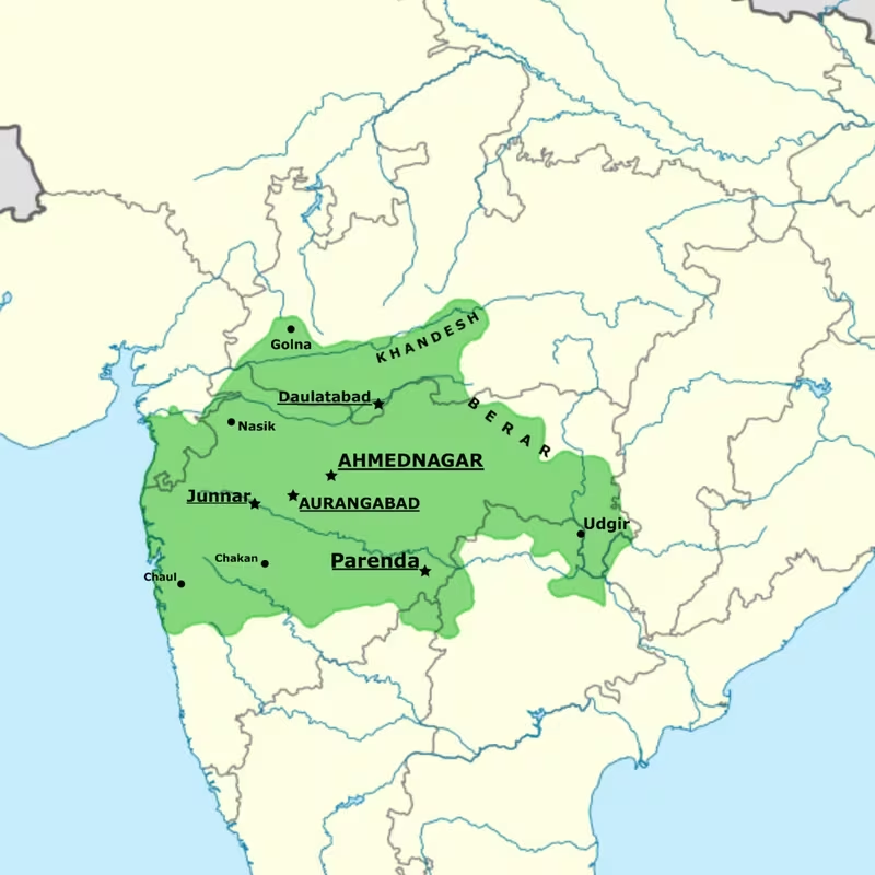
Ahmadnagar Sultanate at Its Territorial Zenith, c. 1574
Introduction
The annexation of Berar in 1574 placed the Ahmadnagar Sultanate at the greatest territorial extent recorded for the Nizam Shahi kingdom. Ruled by Murtaza Nizam Shah I, the state stretched across a strategically positioned part of the northwestern Deccan, between the sultanates of Gujarat and Bijapur. Its political centre was Ahmadnagar, a purpose-built capital founded in 1494, while older forts such as Junnar and Daulatabad anchored the routes and defensive landscape around it.
This map focuses on the period from 1574 to 1586: the years between the incorporation of Berar and the Mughal invasion during the reign of Akbar. It is a map of political geography rather than a claim that every frontier can be drawn as a precise modern boundary. Medieval Deccan states exercised authority through forts, governors, revenue districts, military commanders, alliances, and changing zones of influence. The Nizam Shahi realm therefore appears here as a core territory surrounded by contested spaces and neighbouring powers.
The sultanate was founded in 1490 by Malik Ahmad Nizam Shah I, who declared independence from the Bahmani Sultanate. Over the next century, its rulers developed Ahmadnagar into a major Persianate court, fortified Daulatabad and other strongholds, participated in the coalition that defeated Vijayanagara at Talikota in 1565, and resisted repeated pressure from the Mughal Empire. Its final annexation took place in 1636, when Aurangzeb, then Mughal viceroy of the Deccan, defeated the remaining Nizam Shahi regime and divided its territory between the Mughals and Bijapur.
Historical Context
From Bahmani province to independent sultanate
The Ahmadnagar Sultanate emerged from the political fragmentation of the Bahmani Sultanate. Malik Ahmad Nizam Shah I was the son of Nizam-ul-Mulk Malik Hasan Bahri, a prominent Bahmani official. The family is associated with the Kulkarnis of Pathri in Marathwada. Malik Ahmad served as governor of Beed and neighbouring districts, including the area around Daulatabad and Junnar.
The decisive break came after Malik Ahmad defended Junnar against forces sent by the Bahmani ruler. The account of his rise records several successful military actions, including a night attack against a larger army led by Sheikh Muaddi Arab, resistance to an army of 18,000 under Azmut-ul-Dabir, and victory over forces commanded by the Bahmani general Jahangir Khan. On 28 May 1490, Malik Ahmad declared independence and established the Nizam Shahi dynasty.
The new kingdom initially operated from Junnar, whose fort later became known as Shivneri. The choice reflected the importance of fortified upland centres in the Deccan. In 1494, Malik Ahmad laid the foundation of Ahmadnagar, creating a new capital that was described as comparable to Cairo and Baghdad within a few years of its construction. In 1499, he secured the great fortress of Daulatabad. These actions established the basic political geography represented on the map: a new capital at Ahmadnagar, an older fortified centre at Junnar, and Daulatabad as a powerful secondary stronghold.
The first successors
Malik Ahmad died in 1510. His son Burhan Nizam Shah I succeeded him at the age of seven, with the administration initially controlled by Mukammal Khan and his son. Burhan later converted to Nizari Isma'ili Shi'a Islam under the influence of Shah Tahir, a refugee from Persia and a court official. This conversion shaped the religious and court culture of the dynasty.
Burhan ruled until 1553 and was succeeded by his son Hussain Nizam Shah I. During Hussain's reign, the sultanate became deeply involved in the rivalries among the Deccan states and Vijayanagara. The political geography of the region was not defined only by fixed frontiers. It was also shaped by control over places such as Kalyan, by diplomatic exchanges, by dynastic marriages, and by military coalitions.
Talikota and the Deccan coalition
In the 1560s, Rama Raya, the de facto ruler of Vijayanagara, made repeated efforts to maintain control over Kalyan and conducted diplomacy with the Deccan sultanates. The surviving narrative presents these exchanges as increasingly hostile. In response, Hussain Nizam Shah I of Ahmadnagar, Ali Adil Shah I of Bijapur, Ali Barid Shah I of Bidar, and Ibrahim Quli Qutb Shah Wali of Golconda formed a coalition against Vijayanagara.
The allied armies met Vijayanagara at Talikota in late January 1565. Hussain Nizam Shah was a leading figure in the campaign. The battle ended in the defeat of Vijayanagara's forces, and Rama Raya was beheaded by Sultan Hussain Nizam Shah according to the historical account. Talikota is therefore shown as a major military event connected to Ahmadnagar's wider Deccan diplomacy, even though the battle site lay outside the sultanate's northwestern heartland.
Hussain died in 1565, shortly after the battle. His minor son Murtaza Nizam Shah I succeeded him, with his mother Khanzada Humayun acting as regent for several years. The young ruler's reign eventually brought the Nizam Shahi state to its territorial zenith.
Expansion under Murtaza Nizam Shah I
Murtaza Nizam Shah I annexed Berar in 1574. This acquisition enlarged the northern and northeastern reach of the sultanate and is the defining territorial event of the map. Berar's incorporation placed additional agricultural and strategic districts under Nizam Shahi authority, although the administrative details and exact frontier line are not fixed in the surviving account.
Murtaza also launched an unsuccessful campaign into Bijapur in 1580, after the death of Ali Adil Shah I. The campaign demonstrates that the Nizam Shahi state was not merely defending its territory; it also sought to influence the balance of power among the Deccan sultanates.
In 1586, the Mughal emperor Akbar sent an invasion towards Ahmadnagar. Mughal forces approached the capital but were resisted and withdrew towards the recently annexed Ellichpur. The city was sacked and razed during the episode, but the Mughals were ultimately expelled from Ahmadnagar territory. The invasion ended in a Mughal setback, although the conflict exposed the vulnerability of the sultanate's northern frontier.
Crisis after 1588
Murtaza's reign ended violently in 1588 when he was murdered by his son Miran Hussain. Miran Hussain ruled for little more than ten months before being imprisoned. Ismail Nizam Shah, a cousin of Miran Hussain, was then placed on the throne, while actual power rested with Jamal Khan, leader of the Habshi group at court.
Jamal Khan actively promoted the Mahdawi movement. His authority was challenged, and he was killed at the Battle of Rohankhed in 1591. Ismail was captured and confined by his father, Burhan Nizam Shah II, who became ruler. Burhan outlawed Mahdawia and restored Shi'ism as the state religion.
After Burhan's death, a civil war followed. The struggle was eventually won by Chand Bibi, who became regent for the infant sultan Bahadur Nizam Shah. She led the defence of Ahmadnagar against a Mughal invasion and secured support from Bijapur and Golconda. Her regency illustrates the importance of military alliances and fortifications in preserving Nizam Shahi authority when dynastic succession was contested.
Chand Bibi died in July 1600. Ahmadnagar was then conquered by the Mughals, and Bahadur Nizam Shah was imprisoned. This did not immediately end all Nizam Shahi resistance. Much of the former kingdom remained in the hands of influential officials and military commanders.
Malik Ambar and the restored Nizam Shahi regime
In 1600, Malik Ambar and other Ahmadnagar officials rejected Mughal control and proclaimed Murtaza Nizam Shah II as ruler. A new capital was established at Paranda. Malik Ambar became prime minister and vekīl-us-saltanat, or chief representative of the state.
The capital later moved from Paranda to Junnar and Ausa, and then to Khadki, a new city that was later known as Aurangabad. These shifts reveal how political geography changed in response to military pressure. Ahmadnagar city had been incorporated into the Mughal Empire, so the surviving Nizam Shahi administration required alternative centres from which to govern and mobilise resistance.
Malik Ambar's administration also introduced a revenue system based on land classification and measurement. Lands were assessed according to fertility, and several years were taken to determine average yields. Revenue farming was abolished. The initial assessment was set at two-fifths of the actual produce in kind, while later cultivators could pay a cash equivalent of approximately one-third of the yield. Actual collections varied with crop conditions. This system connected territory, agriculture, and state finance more closely than a simple map of forts and capitals might suggest.
After Malik Ambar died in May 1626, his son Fath Khan surrendered to the Mughals during the siege of Daulatabad in 1633. He handed over the young Nizam Shahi ruler Hussain Shah, who was sent as a prisoner to Gwalior Fort. Shahaji, a Nizam Shahi jagirdar and general, then established an infant member of the dynasty, Murtaza Nizam Shah III, with support from Bijapur.
The final phase ended in 1636. Aurangzeb, serving as Mughal viceroy of the Deccan, defeated Shahaji and partitioned the remaining Nizam Shahi territory between the Mughal Empire and Bijapur.
Territorial Extent and Boundaries
The mapped territorial moment
The map uses 1574 as its principal date because Berar was annexed during the reign of Murtaza Nizam Shah I. The territory shown should be understood as the sultanate's maximum recorded political extent in the supplied historical account, not as a universally agreed line surveyed on the ground.
The Ahmadnagar Sultanate occupied the northwestern Deccan. Its position placed it between Gujarat to the northwest and Bijapur to the southwest and west. The wider Deccan political environment also included Bidar and Golconda, while Vijayanagara lay to the south. The Mughal Empire became an increasingly important power to the north and northeast, especially after Mughal armies began intervening directly in the Deccan.
The state was composed of a core around Ahmadnagar and a wider group of districts, forts, and acquired territories. Authority could be strongest around a capital or fortified centre and more variable in frontier areas. A modern political map tends to imply a continuous, evenly administered territory; the Nizam Shahi landscape was instead structured by overlapping military, fiscal, dynastic, and local relationships.
Northern frontier
Berar formed the principal northern expansion shown on the map. It was annexed in 1574 and brought the sultanate to its territorial zenith. The region is represented as an incorporated Nizam Shahi possession during the selected period.
The northern frontier became especially important during the Mughal invasion of 1586. Mughal forces advanced towards Ahmadnagar and then withdrew towards Ellichpur, a city in the Berar region. The direction of this movement demonstrates the strategic connection between the capital and the northern districts. It also shows why Berar's incorporation had consequences beyond increasing the area coloured on a map: it placed the Nizam Shahi state in closer contact with Mughal military power.
The exact northern boundary cannot be reconstructed as a precise line from the historical account. The map should therefore distinguish the Berar zone from a confidently surveyed frontier.
Southern frontier
The southern and southeastern political environment was shaped by Bijapur, Bidar, Golconda, and Vijayanagara. The Battle of Talikota in 1565 brought Ahmadnagar into a coalition with Bijapur, Bidar, and Golconda against Vijayanagara. The coalition's existence does not mean that the four sultanates formed a single state. They remained separate powers whose interests could converge against a common rival.
Murtaza Nizam Shah's campaign into Bijapur in 1580 indicates that the frontier with Bijapur was contested. The available historical record does not provide a stable southern boundary for the whole period. Instead, the map marks Bijapur as a neighbouring state and identifies military interaction as a central feature of the southern political landscape.
Eastern frontier
The eastern side of the Nizam Shahi sphere was connected to the political world of Bidar and Golconda. Golconda participated in the Talikota coalition, while Bidar was also one of the allied Deccan sultanates. These alliances were diplomatic and military arrangements rather than evidence of territorial subordination to Ahmadnagar.
The account does not establish a single eastern boundary or list all eastern districts administered by Ahmadnagar. The map therefore uses a graduated frontier treatment rather than presenting every edge as equally certain.
Western frontier and the coast
The sultanate's western setting connected its inland Deccan centres with the Konkan and the Arabian Sea. Janjira Fort, in the Murud area of present-day Maharashtra, is associated with Malik Ambar's building activity and with the strategic defence of the region. After its construction in 1567, Janjira was important to the Sidis in resisting attempts by the Marathas, Mughals, and Portuguese to capture it.
Janjira should not be interpreted automatically as a uniformly administered Nizam Shahi coastal province. Its importance lay in the strategic relationship between inland power, coastal fortification, and maritime threats. The fort's presence on the map widens the focus beyond the inland capital and demonstrates that the political geography of Ahmadnagar included a coastal defensive dimension.
Direct control, influence, and contested space
The available record does not provide a complete classification of every district as directly ruled, tributary, allied, or disputed. Several distinctions are nevertheless clear:
- Ahmadnagar was the principal capital and headquarters of the sultanate.
- Junnar and Daulatabad were major centres of Nizam Shahi power.
- Berar was annexed in 1574.
- Bijapur, Bidar, and Golconda were independent sultanates that could become allies.
- Vijayanagara was a major rival defeated at Talikota.
- The Mughal Empire was an external imperial power whose armies invaded and eventually annexed the sultanate.
- Janjira was a strategic coastal fort associated with the Sidis and with resistance to several powers.
These categories are reflected in the map through different symbols and boundary treatments.
Administrative Structure
The sultan and the court
The Nizam Shahi state was ruled by the Nizam Shahi dynasty. The sultan stood at the centre of the political order, but the effective distribution of power varied according to age, succession, factional conflict, and the strength of ministers and military commanders.
Burhan Nizam Shah I inherited the throne as a child, and Mukammal Khan initially controlled the administration. During Murtaza Nizam Shah I's minority, his mother Khanzada Humayun served as regent. Later, Chand Bibi governed as regent for Bahadur Nizam Shah. These episodes show that the capital was not simply a royal residence; it was the centre of regency councils, factional competition, military planning, and dynastic legitimacy.
Revenue districts and local administration
The account records that Malik Ahmad had governed Beed and other districts before establishing the sultanate. This early experience in provincial administration contributed to the formation of the new state.
The revenue system associated with Malik Ambar classified lands by fertility and assessed their yields over several years. Revenue farming was abolished, and assessments were linked to the productivity of individual plots. Although the available description does not provide a complete list of provinces, it demonstrates that Nizam Shahi administration depended on local agricultural information and regular fiscal assessment.
The system was not entirely rigid. Cultivators were allowed to pay in cash rather than in kind, and actual collections varied with the condition of crops. This flexibility acknowledged the environmental and agricultural variability of the Deccan.
Capitals and changing centres
The capital sequence is essential to understanding the map:
- Junnar: The initial capital, centred on its fort.
- Ahmadnagar: Founded in 1494 as the new capital and the principal Nizam Shahi political centre.
- Paranda: Used as a capital by Malik Ambar after the Mughal conquest of Ahmadnagar city in 1600.
- Junnar and Ausa: Later capital locations during the continuing resistance.
- Khadki: A new city established under Malik Ambar and later known as Aurangabad.
Daulatabad functioned as a secondary capital and major fortress. Its role was distinct from that of Ahmadnagar: it was both a political centre and a formidable military position.
Local power and military officials
The survival of the Nizam Shahi cause after 1600 depended heavily on officials, jagirdars, commanders, and regional elites. Malik Ambar became the central figure in this phase, while Shahaji later acted as a jagirdar and general who helped place Murtaza Nizam Shah III on the throne.
The map's fortified sites should therefore be read as nodes in a political system. A fort could serve as a garrison, treasury, administrative base, refuge, or point of resistance. Control of a capital without control of the surrounding forts did not necessarily mean that the entire former kingdom had been subdued.
Infrastructure and Communications
Forts as infrastructure
The best-attested infrastructure of the Ahmadnagar Sultanate is its network of forts and fortified centres. The record identifies Junnar or Shivneri, Daulatabad, Paranda, Ausa, Dharur, Lohagad, and Ahmadnagar Fort among the sites improved or constructed under Nizam Shahi rule.
These strongholds performed several functions:
- They protected capitals and administrative centres.
- They controlled approaches through the Deccan plateau and adjoining regions.
- They housed troops and officials.
- They provided secure locations during dynastic conflict.
- They allowed resistance to continue after a capital had fallen.
- They connected inland authority to routes leading towards the coast and neighbouring states.
Ahmadnagar Qila, a land fort, served as the headquarters of the sultanate. Daulatabad's massive fortification made it a critical military and political centre. Junnar's fort anchored the first capital, while Paranda and Ausa became especially important during the later anti-Mughal struggle.
Roads and movement
A complete road map for the Nizam Shahi period cannot be securely drawn from the surviving account used here. The historical record identifies movement between capitals, forts, and battle zones, but does not preserve a comprehensive list of roads, distances, bridges, caravan stations, or postal relays.
The map consequently does not draw invented route lines. Instead, it presents the principal centres as connected political nodes. The known movement of armies—from Ahmadnagar towards Berar, from the Nizam Shahi territory towards Bijapur, and between later capitals—indicates that communication across the plateau depended on practical links between fortified and administrative sites.
Administrative communication
The operation of a revenue system based on crop assessments required communication between cultivators, local officials, and the central administration. Malik Ambar's system, with its classification of land and calculation of average yield, implies an organised flow of fiscal information. However, the names and structure of postal offices or official courier systems are not specified in the account.
It is therefore safer to show administrative communication as an institutional relationship rather than as a detailed postal network. The capital depended on reports from districts, forts, and agricultural areas; frontier commanders required information about neighbouring states; and regents and ministers coordinated military responses from changing political centres.
Maritime capabilities
Janjira provides the clearest maritime connection associated with the sultanate. Malik Ambar is credited with building Janjira Fort in the Murud area. The fort later served as a strategic base for the Sidis and resisted attacks by the Marathas, Mughals, and Portuguese.
The available record does not describe a Nizam Shahi navy, a fleet structure, or a complete list of ports under direct royal control. Janjira is therefore marked as a coastal strategic site, not as proof of a centrally organised maritime empire.
Economic Geography
Agriculture and revenue
Agriculture was central to the fiscal geography of Ahmadnagar. Malik Ambar's revenue reforms classified land according to fertility and attempted to establish an accurate average yield over a number of years. The first revenue assessment was approximately two-fifths of the actual produce in kind; later, cultivators could pay a cash equivalent of around one-third of the yield.
This system shows that the territory was understood through fields, plots, crops, and changing seasonal conditions. Revenue was not a uniform charge applied without regard to land quality. Actual collections varied according to crop conditions, creating a direct relationship between environmental fluctuation and state income.
The map can identify the sultanate's agricultural districts in broad geographic terms, but the surviving account does not provide a full crop map or a statistical estimate of production. No population total, yield table, or complete revenue register is available here, so such figures should not be added.
Berar and territorial expansion
The annexation of Berar in 1574 was both a political and economic development. Its incorporation expanded the territory available for taxation and increased the number of districts linked to the Nizam Shahi administration. The annexation also changed the state's strategic position by bringing it closer to the Mughal sphere.
The 1586 Mughal invasion illustrates the connection between economic and military geography. Ellichpur, in the recently annexed northern region, became the direction of Mughal withdrawal after the forces approaching Ahmadnagar were repelled. The northern districts were therefore not peripheral to the sultanate's history; they were part of the zone through which imperial armies moved.
Trade and urban life
The capital Ahmadnagar was modelled on major Persianate cities and was described as comparable to Cairo and Baghdad within a few years of its foundation. This description points to the city's role as a major courtly and urban centre, although the account does not supply a detailed list of markets, commodities, guilds, or merchant communities.
The Nizam Shahi state occupied a position between Gujarat, Bijapur, and the wider Deccan. Such a location created opportunities for exchange and diplomatic contact, but the available record does not specify the full commercial routes or the goods transported along them. A responsible map should therefore avoid drawing precise trade corridors unless supported by additional evidence.
Ahmadnagar's urban importance was reinforced by its palaces, gardens, mosques, tombs, and administrative buildings. Farah Bagh, completed as the centrepiece of a large palace complex in 1583, represented the wealth and ceremonial culture of the royal household. Hasht Bihisht Bagh and Lakkad Mahal formed part of the wider architectural landscape around the capital.
No unsupported commodity map
The historical account does not identify a complete set of commodities associated with the sultanate. Nor does it provide securely documented major ports, annual trade volumes, or population estimates. The economic layer of this map therefore emphasises land revenue, urban court culture, fortified centres, and the territorial significance of Berar rather than presenting speculative trade statistics.
Cultural and Religious Geography
Shi'a identity and court culture
Burhan Nizam Shah I converted to Nizari Isma'ili Shi'a Islam under the guidance of Shah Tahir. Burhan Nizam Shah II later outlawed the Mahdawi movement and restored Shi'ism as the state religion after the political crisis surrounding Ismail Nizam Shah and Jamal Khan.
These episodes show that religious geography was connected to court politics. Religious affiliation shaped royal legitimacy, ministerial alliances, and factional struggles. It should not, however, be represented as a simple uniform conversion of every inhabitant of the territory. The historical account describes the dynasty's religious orientation and state policy, not the complete religious composition of all districts.
Persianate connections
The dynasty's Shi'a orientation was reflected in its cultural and architectural choices. Ahmadnagar was modelled on major Persianate cities, and Persian literary culture received royal patronage. The court also supported Sanskrit scholarship, represented in the account by the works of Sabaji Pratap and Bhanudatta.
This combination of Persianate court culture and Sanskrit intellectual activity is important for interpreting the map. Cultural influence did not follow a single language or religious boundary. The Nizam Shahi realm was shaped by the interaction of Deccani political traditions, Persianate forms, Islamic religious institutions, and Sanskrit learning.
Deccan painting
The Ahmadnagar Sultanate is associated with the earliest extant school of painting among the Deccan sultanates. This artistic tradition forms part of the cultural layer of the map, although the available account does not list individual paintings, workshops, or a complete distribution of surviving manuscripts.
The court's patronage of painting, literature, gardens, palaces, mosques, and tombs demonstrates that the sultanate's historical geography was not limited to war and administration. Ahmadnagar was also a centre of artistic production and elite cultural life.
Architecture and monuments
The principal architectural sites associated with the sultanate include:
- Ahmadnagar Fort: The land fort that served as the headquarters of the sultanate.
- Farah Bagh: A palace complex in Ahmadnagar, completed in 1583.
- Hasht Bihisht Bagh: A palace and garden complex associated with Nizam Shahi architecture.
- Lakkad Mahal: A structure built in the Farah Bagh complex.
- Junnar or Shivneri Fort: The first capital's major stronghold.
- Daulatabad Fort: A major fortress and secondary capital.
- Paranda Fort: A stronghold and later capital during Malik Ambar's resistance.
- Ausa, Dharur, and Lohagad: Fortified sites improved under Nizam Shahi rule.
- Janjira Fort: A coastal stronghold credited to Malik Ambar.
- Tombs of Salabat Khan and Changiz Khan: Tombs of nobles near Ahmadnagar.
- Shrines associated with Shah Sharif and Bava Bangali: Religious monuments in and around the capital region.
The map marks these locations as cultural and strategic nodes. Their functions could overlap: a fort could also be a political centre, and a city could contain palaces, mosques, tombs, and administrative buildings.
Religious and cultural diversity
The Nizam Shahi court supported Shi'a Islam and Persianate culture, but it also patronised Sanskrit scholarship. The account does not provide a complete map of temples, mosques, shrines, languages, or communities across every district. It would therefore be misleading to draw rigid cultural borders.
Instead, the cultural geography should be read through institutions and sites: the Shi'a court, Persianate urban design, Deccan painting, Sanskrit scholarship, palaces, mosques, tombs, and shrines. These features reveal overlapping cultural zones rather than isolated civilisational blocks.
Military Geography
The fort-centred state
The military geography of Ahmadnagar was organised around fortified centres. Junnar, Daulatabad, Ahmadnagar, Paranda, Ausa, Dharur, Lohagad, and Janjira each represent different aspects of the defensive landscape.
Junnar was the first capital and provided an early base from which Malik Ahmad resisted Bahmani forces. Daulatabad was secured in 1499 and later became a secondary capital. Ahmadnagar Fort served as the headquarters of the state. After Ahmadnagar city fell to the Mughals in 1600, Paranda, Ausa, Junnar, and Khadki became alternative centres for continuing Nizam Shahi rule.
The repeated movement of capitals suggests that defence was inseparable from administration. When a city became vulnerable, the court could shift to another fortified site, preserving dynastic claims and military organisation.
Early campaigns of Malik Ahmad
Before declaring independence, Malik Ahmad defended Junnar against Bahmani attacks. He defeated forces led by Sheikh Muaddi Arab in a night attack, resisted a larger army of 18,000 under Azmut-ul-Dabir, and defeated an army commanded by Jahangir Khan.
These victories made the Junnar region the military birthplace of the sultanate. They also demonstrated the importance of surprise, local knowledge, and fortified positions in Deccan warfare. The historical account does not provide a complete description of army organisation, weaponry, or troop distribution, so those elements are not represented as fixed map layers.
Talikota, 1565
Talikota was the most consequential military episode of the sixteenth-century Deccan coalition. Hussain Nizam Shah I of Ahmadnagar joined the rulers of Bijapur, Bidar, and Golconda against Vijayanagara. The coalition assembled after a period of diplomatic hostility involving Rama Raya and the Deccan sultanates.
The battle took place in late January 1565. Hussain Nizam Shah personally beheaded Rama Raya, according to the historical account. Ahmadnagar's participation in the coalition demonstrates that its military geography extended beyond its immediate heartland. The sultanate's security was connected to the wider balance of power across the Deccan.
Expansion and the Bijapur campaign
Murtaza Nizam Shah I expanded the kingdom by annexing Berar in 1574. In 1580, he attempted a campaign into Bijapur after the death of Ali Adil Shah I. The campaign was unsuccessful.
These two episodes show contrasting forms of military geography. Berar became a lasting territorial acquisition in the account, while the Bijapur campaign demonstrates the limits of expansion against a neighbouring Deccan sultanate. The map distinguishes incorporated territory from campaign direction and contested space.
Mughal invasion, 1586
Akbar's Mughal Empire invaded Ahmadnagar in 1586. Mughal forces approached the capital, but the Nizam Shahi defence forced them to withdraw towards Ellichpur. During the retreat, Ellichpur was sacked and razed. The Mughals were eventually expelled from Ahmadnagar territory.
The episode is important because it links the northern frontier to the capital. The sultanate's territorial zenith did not remove the danger of invasion; it increased the length and complexity of the frontier that had to be defended. The 1586 campaign also foreshadowed the sustained Mughal involvement that eventually brought the dynasty to an end.
Chand Bibi's defence
During the succession crisis after Burhan Nizam Shah II, Chand Bibi became regent for Bahadur Nizam Shah. She repelled a Mughal invasion with reinforcements from Bijapur and Golconda.
Her defence illustrates the role of alliances in Deccan military geography. Ahmadnagar's survival depended not only on its own forts and forces but also on the willingness of neighbouring sultanates to intervene. The alliance network was not permanent or unconditional, but it could temporarily prevent Mughal conquest.
Malik Ambar's resistance
After the Mughal conquest of Ahmadnagar city in 1600, Malik Ambar continued the Nizam Shahi cause from alternative centres. His government used Paranda, Junnar, Ausa, and Khadki as successive capitals. The shifting court and the survival of a claimant to the throne allowed resistance to continue even when the old capital had been incorporated into the Mughal Empire.
Malik Ambar's revenue reforms strengthened the fiscal foundations of this resistance. His fortification and administrative policies connected the countryside to military mobilisation. The siege of Daulatabad in 1633, however, led to Fath Khan's surrender and the handover of Hussain Shah. Although Shahaji briefly revived the dynasty through Murtaza Nizam Shah III, Aurangzeb defeated the remaining regime in 1636.
Troop numbers and military estimates
The historical account provides one explicit figure: an army of 18,000 led by Azmut-ul-Dabir during the early struggle around Junnar. It does not provide reliable total army sizes for the 1574 territorial zenith, the Talikota coalition, Chand Bibi's defence, or Malik Ambar's later campaigns.
No general estimate should therefore be assigned to the Nizam Shahi military on this map. The military layer shows forts, capitals, battles, and documented campaigns rather than speculative troop concentrations.
Political Geography
The Deccan sultanates
Ahmadnagar existed within a competitive political system that included Bijapur, Bidar, and Golconda. These states were independent but could cooperate when faced with a common enemy. Their coalition at Talikota in 1565 is the clearest example.
The same neighbouring states could also be rivals. Murtaza Nizam Shah's unsuccessful campaign into Bijapur in 1580 shows that cooperation against Vijayanagara did not end competition among the sultanates. Political geography in the Deccan was therefore fluid: alliance, rivalry, dynastic marriage, and military intervention could coexist.
Gujarat
The Ahmadnagar Sultanate was located between Gujarat and Bijapur. Gujarat formed part of the wider regional political setting and helped define the sultanate's northwestern position. The historical account does not specify a detailed Nizam Shahi-Gujarat frontier or a complete record of their commercial and diplomatic relations, so the map labels Gujarat as a neighbouring power without drawing unsupported campaign routes.
Vijayanagara
Vijayanagara was the major southern rival in the period leading to Talikota. Rama Raya's efforts to maintain control over Kalyan and his diplomatic dealings with the Deccan sultanates contributed to the formation of the anti-Vijayanagara coalition.
The defeat of Vijayanagara in 1565 altered the balance of power across the Deccan. Ahmadnagar's participation gave the Nizam Shahi dynasty a role in a conflict whose consequences extended well beyond its own capital and northern territories.
The Mughal Empire
Mughal intervention transformed Ahmadnagar's political geography. Akbar's invasion in 1586 was resisted, but the Mughal Empire returned to the Deccan during the later succession crises. Ahmadnagar city was conquered in 1600, and the surviving Nizam Shahi administration continued from alternative capitals.
Aurangzeb's final campaign in 1636 ended the dynasty's independence. The sultanate was divided between the Mughal Empire and Bijapur. This partition represents the final transformation of the territory first established by Malik Ahmad in 1490.
Dynastic politics and legitimacy
The list of Nizam Shahi rulers includes several short reigns and rival claimants:
- Ahmad Nizam Shah I, 1490–1510
- Burhan Nizam Shah I, 1510–1553
- Hussain Nizam Shah I, 1553–1565
- Murtaza Nizam Shah I, 1565–1588
- Hussain Nizam Shah II, 1588–1589
- Ismail Nizam Shah, 1589–1591
- Burhan Nizam Shah II, 1591–1595
- Bahadur Nizam Shah, 1595–1600
- Ahmad Nizam Shah II, 1596
- Murtaza Nizam Shah II, 1600–1610
- Burhan Nizam Shah III, 1610–1631
- Hussain Nizam Shah III, 1631–1633
- Murtaza Nizam Shah III, 1633–1636
The overlapping dates reveal the instability of the final decades. Ahmad Nizam Shah II's brief appearance in 1596 and the later restoration of Murtaza Nizam Shah II and Murtaza Nizam Shah III reflect the use of royal names and dynastic claimants in struggles for political legitimacy.
Reading the Map
Core territory and frontier zones
The dark central colour identifies the Nizam Shahi heartland and the territory associated with the post-1574 expansion. Berar is included because it was annexed by Murtaza Nizam Shah I. The boundary is intentionally approximate. A fort, city, or district might be held by a governor or commander even when the surrounding countryside was contested.
Neighbouring states are shown in a contrasting tone. This does not imply that their borders were static. Bijapur, Bidar, Golconda, Gujarat, Vijayanagara, and the Mughal Empire entered different relationships with Ahmadnagar at different moments.
Capitals as moving political centres
The capital symbols should be followed chronologically. Ahmadnagar is the principal centre for the map's 1574–1586 focus, but Junnar and Daulatabad explain the earlier formation of the state. Paranda, Ausa, and Khadki belong mainly to the later resistance after 1600.
This sequence is one of the map's most important historical features. It shows that the Nizam Shahi state was not defined by one city alone. Political authority could be relocated while the dynasty, administration, and military struggle continued.
Forts and political control
Fort symbols represent more than architecture. They indicate the places from which a ruler could defend territory, store supplies, supervise movement, and maintain authority during periods of instability. Ahmadnagar Fort served as the headquarters of the sultanate, while Daulatabad and Junnar were major centres of earlier Nizam Shahi power.
The presence of a fort does not automatically establish direct control over a wide surrounding region. The map therefore uses fort symbols as nodes rather than as evidence of perfectly concentric territorial administration.
Battle symbols
Talikota appears as a major coalition battle in 1565. The 1586 Mughal invasion is shown near Ahmadnagar and linked to the movement towards Ellichpur. Later events around Paranda and Daulatabad belong to the post-1600 phase and explain the eventual end of Nizam Shahi independence.
The map does not display battles for which the account supplies no location. Nor does it add conventional military arrows where the direction of movement is not clearly documented.
Legacy and Decline
The end of the independent sultanate
The territorial configuration established after Berar's annexation in 1574 lasted only within a wider period of political uncertainty. Murtaza Nizam Shah I's expansion was followed by internal factional conflict, assassinations, short reigns, regencies, and Mughal intervention.
The Mughal conquest of Ahmadnagar in 1600 ended the city's role as the uncontested capital, but it did not immediately extinguish Nizam Shahi authority. Malik Ambar restored a claimant, moved the capital, reformed revenue administration, and continued resistance. This later phase demonstrates that the fall of a capital and the end of a dynasty were not the same event.
In 1633, the surrender of Daulatabad and the imprisonment of Hussain Shah weakened the restored regime. Shahaji's attempt to continue the dynasty through Murtaza Nizam Shah III delayed the final settlement. Aurangzeb's campaign in 1636 finally defeated Shahaji and partitioned the sultanate between the Mughal Empire and Bijapur.
Administrative and military legacy
Malik Ambar's revenue system remained significant because it tied assessment to land fertility, average yield, and actual crop conditions. The abolition of revenue farming and the attempt to establish predictable assessments reflected a sustained effort to make territory fiscally legible.
The sultanate also left a dense architectural legacy. Ahmadnagar's palaces, gardens, mosques, tombs, and fortifications preserve the ambitions of the Nizam Shahi court. Farah Bagh, Hasht Bihisht Bagh, Ahmadnagar Fort, Daulatabad, Junnar, Paranda, Ausa, Dharur, Lohagad, and Janjira together reveal a political culture in which royal display and military security were closely linked.
Cultural legacy
Ahmadnagar is associated with the earliest extant Deccan school of painting. The dynasty patronised Persian literature and gave Sanskrit scholarship a place within its cultural world. Its Shi'a identity shaped court life and state policy, while the broader Deccan setting produced interactions across political, linguistic, and religious boundaries.
The legacy of the sultanate is therefore visible in several kinds of historical geography:
- The urban form of Ahmadnagar and later Khadki.
- The fortified landscapes of the Deccan.
- The religious and courtly architecture of the Nizam Shahi period.
- The development of Deccan painting.
- The revenue and administrative practices associated with Malik Ambar.
- The diplomatic and military traditions of the Deccan sultanates.
Why the 1574 map moment matters
The year 1574 captures the Ahmadnagar Sultanate at its widest recorded extent, but it also marks the beginning of a period in which territorial expansion and external pressure existed together. Berar enlarged the state; the 1580 Bijapur campaign showed continuing regional rivalry; and the Mughal invasion of 1586 demonstrated the growing challenge from the north.
A map of this moment should therefore be read as a snapshot within a longer process. It shows the Nizam Shahi state before the Mughal conquest of Ahmadnagar city, before Malik Ambar's capital shifts, and before the final annexation of 1636. Its most important message is not simply that the sultanate occupied a large area. It is that power in the medieval Deccan depended on the relationship between capitals, forts, revenue districts, dynastic legitimacy, and alliances across a contested plateau.
Chronology of the Nizam Shahi Territory
| Date | Event | Geographic significance |
|---|---|---|
| 1490 CE | Malik Ahmad declares independence from the Bahmani Sultanate | Formation of the Nizam Shahi state |
| 1490s | Junnar serves as the initial capital | The early state is centred on a fortified upland site |
| 1494 CE | Foundation of Ahmadnagar | Establishment of the new principal capital |
| 1499 CE | Daulatabad is secured by Malik Ahmad | Expansion of the fortified political core |
| 1510 CE | Malik Ahmad dies; Burhan Nizam Shah I succeeds | Beginning of a child reign and regency administration |
| 1553 CE | Burhan Nizam Shah I dies; Hussain Nizam Shah I succeeds | Transition to the ruler who later leads the Talikota coalition |
| 1565 CE | Battle of Talikota | Ahmadnagar joins Bijapur, Bidar, and Golconda against Vijayanagara |
| 1565 CE | Hussain Nizam Shah I dies; Murtaza Nizam Shah I succeeds | Beginning of Murtaza's reign |
| 1574 CE | Berar is annexed | The sultanate reaches its territorial zenith |
| 1580 CE | Campaign into Bijapur fails | Evidence of continuing rivalry among Deccan states |
| 1586 CE | Mughal invasion is repelled | Ahmadnagar temporarily resists Akbar's intervention |
| 1588 CE | Murtaza Nizam Shah I is murdered | Intensification of dynastic instability |
| 1591 CE | Jamal Khan is killed at Rohankhed | Collapse of the faction associated with his rule |
| 1595–1600 CE | Chand Bibi acts as regent for Bahadur Nizam Shah | Ahmadnagar resists Mughal pressure with allied support |
| 1600 CE | Ahmadnagar city is conquered by the Mughals | Malik Ambar establishes a restored regime at Paranda |
| 1600s–1620s | Capital shifts through Paranda, Junnar, Ausa, and Khadki | Political authority adapts to Mughal pressure |
| 1626 CE | Malik Ambar dies | Leadership passes to his son Fath Khan |
| 1633 CE | Daulatabad falls; Hussain Shah is surrendered | Major weakening of the restored Nizam Shahi regime |
| 1636 CE | Aurangzeb defeats Shahaji and partitions the sultanate | End of independent Nizam Shahi rule |
Map Notes and Historical Cautions
This map uses approximate geographic coordinates for places identified with the historical centres and fortifications of the Ahmadnagar Sultanate. The coordinate points locate places in the modern landscape; they do not imply that medieval political boundaries followed present-day administrative borders.
The territorial shading represents the political configuration after the annexation of Berar in 1574. The historical account does not provide a cadastral survey, a complete list of provincial borders, or a uniform description of the authority exercised in every frontier district. Boundary lines should therefore be read as a reconstruction of the sultanate's sphere rather than as exact surveyed limits.
The map also separates the 1574–1586 focus from the later history of Malik Ambar. Paranda, Ausa, and Khadki are included because they explain the transformation of Nizam Shahi political space after Ahmadnagar city was conquered in 1600. Their inclusion does not mean that all three functioned as capitals during the period of Murtaza Nizam Shah I's territorial zenith.
No population estimate is supplied for the Ahmadnagar Sultanate in the historical account used for this map. No comprehensive army total, postal network, commodity inventory, or complete trade-route system is established either. These omissions are deliberate: the map prioritises securely identified capitals, forts, political relationships, documented campaigns, and the recorded annexation of Berar.
Frequently Asked Questions
Where was the Ahmadnagar Sultanate located?
The Ahmadnagar Sultanate was located in the northwestern Deccan. It lay between Gujarat and Bijapur and interacted with the neighbouring powers of Bidar, Golconda, Vijayanagara, and the Mughal Empire.
When was the Ahmadnagar Sultanate founded?
Malik Ahmad Nizam Shah I declared independence from the Bahmani Sultanate on 28 May 1490 and established the Nizam Shahi dynasty.
What was the capital of the Ahmadnagar Sultanate?
Ahmadnagar became the principal capital after its foundation in 1494. The state had earlier been centred at Junnar, and Daulatabad served as a major secondary capital. During Malik Ambar's later resistance, the capital moved through Paranda, Junnar, Ausa, and Khadki.
When did Ahmadnagar reach its greatest territorial extent?
The sultanate reached its territorial zenith after Murtaza Nizam Shah I annexed Berar in 1574.
Which battle involved Ahmadnagar and Vijayanagara?
Ahmadnagar joined Bijapur, Bidar, and Golconda at the Battle of Talikota in 1565. The coalition defeated Vijayanagara, and Hussain Nizam Shah I is recorded as having beheaded Rama Raya.
Who defended Ahmadnagar against the Mughals?
Chand Bibi defended Ahmadnagar during the late sixteenth-century Mughal attacks, receiving reinforcements from Bijapur and Golconda. Malik Ambar later continued the Nizam Shahi resistance after Ahmadnagar city was conquered in 1600.
When did the Ahmadnagar Sultanate end?
Aurangzeb defeated the remaining Nizam Shahi regime in 1636 and partitioned its territory between the Mughal Empire and Bijapur.
What was Malik Ambar's contribution?
Malik Ambar led resistance against the Mughals, served as prime minister and vekīl-us-saltanat, moved the capital to alternative centres, and introduced a revenue system based on land fertility and average agricultural yield. He is also credited with constructing Janjira Fort.
What cultural achievements are associated with Ahmadnagar?
The sultanate is associated with the earliest extant Deccan school of painting, Persianate urban and architectural culture, palace and garden complexes, mosques, tombs, forts, Persian literature, and patronage of Sanskrit scholarship.