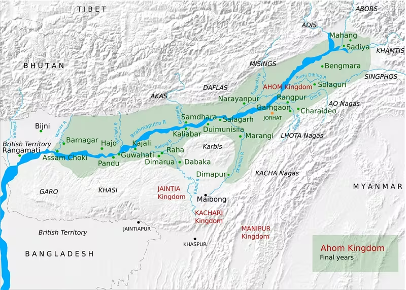
Ahom Kingdom Map, 1228–1826
Introduction
The Ahom Kingdom grew from a small Tai polity in the upper Brahmaputra Valley into a multi-ethnic kingdom that incorporated large parts of present-day Assam. Its conventional history begins with Sukaphaa’s arrival after crossing the Patkai range and ends with the Treaty of Yandabo in 1826, when control passed to the East India Company. The map therefore represents not a fixed empire at a single moment, but a territorial history lasting almost six centuries.
The geography of the kingdom was defined by the Brahmaputra and its tributaries, the eastern hills, the alluvial plains of Upper Assam, and the western frontier around the Manas River. In the sixteenth century, the annexation of the Chutia kingdom and the absorption of territories associated with the Baro-Bhuyans and the Dimasa kingdom transformed the early Ahom polity. In the seventeenth century, repeated wars with the Mughal Empire pushed the kingdom’s western frontier back and forth before the Manas became the boundary after the Ahom victory at Itakhuli in 1682.
The dates 1228 and 1826 are conventional rather than entirely uncontested. The chronology of Sukaphaa’s migration is debated, and some historical and linguistic studies propose later dates for the foundation of the Ahom polity in Assam. The map uses the conventional range while identifying the chronology of the early period as uncertain.
Historical Context
The early Tai polity
According to the conventional Buranji-based chronology, Sukaphaa entered the Brahmaputra Valley in 1228 after crossing the Patkai mountain range from Möng Mao, a Tai polity associated with present-day Dehong in China. He and his followers moved through a landscape of established communities, political formations, forests, marshes, and river plains. The early Ahom settlement was concentrated in the eastern part of the Brahmaputra Valley, especially in Upper Assam.
Sukaphaa is traditionally associated with the establishment of the early Ahom polity and the creation of Charaideo as a principal centre. The first political structure was not yet a fully centralised territorial state. It has been described as a loose confederacy of several mungs organised around a dominant one. The king worked with two major counsellors, the Burhagohain and the Borgohain. By the 1280s, these offices had been assigned independent territories, creating a system in which the king and the two great Gohains exercised authority while also checking one another.
The early Ahom domain was connected to the wider Tai political world. It maintained tributary or allegiance ties with Möng Mao and later with Möng Kawng, known in Buranji traditions as Nara. Some Ahom rulers continued sending tribute until the early fourteenth century, while the kingdom had ceased paying tribute by the early fifteenth century as the power of the older Tai centres declined.
Agriculture, settlement, and Ahomisation
Wet-rice agriculture and water management were central to the early Ahom presence. The Ahoms contributed traditions of embankment construction, water control, and wet-rice cultivation, helping transform selected forested and marshy alluvial areas into level fields capable of retaining water. This was not a wholesale conversion of the entire region. Earlier communities, including the Kacharis, had also practised wet-rice cultivation and controlled fertile riverbanks and water supplies.
The expansion of the Ahom polity involved competition, negotiation, warfare, and incorporation. Communities practising shifting cultivation were gradually brought into the political order. Many people were ceremonially adopted into Ahom clans through a process known as Ahomisation. The category “Ahom” remained politically flexible: the king exercised authority over who belonged to the Ahom social and political community.
This process made the kingdom multi-ethnic. The Tai Ahom population later formed only a minority of the kingdom’s population, while Assamese-speaking and other communities became increasingly prominent. The map’s territorial areas therefore represent a political kingdom rather than an ethnically uniform state.
From Mong Dun Shun Kham to Assam
The early Ahom domain was traditionally known as Mong Dun Shun Kham, often glossed as “a country of golden gardens” or “casket of gold.” A major political transition occurred during the reign of Sudangphaa Bamuni Konwar, conventionally dated to 1397–1407.
Sudangphaa had been raised in a Brahmin household in Habung and was installed after a period of dynastic crisis. He suppressed rebellions and resisted an expedition from Mong Kwang. A treaty fixed the boundary between the two polities at the Patkai range. This settlement represented a movement from implicit subordination toward explicit sovereignty. The kingdom adopted the name Assam in the fifteenth century, a term associated with Shan or Shyam.
Sudangphaa also founded Charagua as a new capital, strengthened royal authority over earlier clan allegiances, and established the singarigharutha coronation ceremony. Brahmanical influence at court increased, although Ahom kings were not formally initiated into Hinduism before 1648.
The sixteenth-century expansion
The reign of Suhungmung Dihingia Raja, conventionally dated to 1497–1539, marked the most decisive early transformation of the kingdom. The militia was consolidated, and the Ahom state began expanding beyond its earlier Upper Assam base.
The Chutia kingdom was the principal early target. Ahom campaigns began in 1513 and culminated in the annexation of the Chutia kingdom in 1523. The conquest brought the Ahom state new territory, political personnel, commanders, warriors, artisan groups, technologies, and access to the Sadiya region. It also brought the Ahoms into more direct contact with hill communities including the Miris, Abors, Mishmis, and Daflas.
The Baro-Bhuyans who controlled parts of central Assam were relocated in 1527 and absorbed into the expanding state as scribes and warriors. In the west, the Ahoms confronted the forces of Bengal under Turbak in 1532. The invading army was defeated, and the Ahom forces pursued the retreating leadership to the Karatoya River.
By 1536, Ahom rule extended to the Kolong River in the Nagaon region. Expansion toward the Doyang–Dhansiri valley was less permanent. Ahom armies occupied Dimapur, the capital of the Dimasa kingdom, on two occasions, but they did not permanently annex Dimapur or the upper Dhansiri valley. Effective Ahom administration remained concentrated in Marangi and the lower Dhansiri valley.
State formation and the mature kingdom
The territorial acquisitions of the sixteenth century were accompanied by institutional changes. Suhungmung adopted the title Swarganarayana, and the Ahom state developed a more elaborate royal ceremonial order. The office of Borpatrogohain was created, along with frontier offices including the Sadiyakhowa Gohain and the Marangikhowa Gohain.
Under Pratap Singha, who ruled from 1603 to 1641, the kingdom acquired many features of its mature administrative system. The Paik system was reorganised into khels in 1609. The offices of Borbarua and Borphukan were established, and the Council of Ministers expanded to five members. Assamese entered the royal court and gradually replaced Ahom as the principal court language.
Pratap Singha also allied with the Koch Hajo branch after the division of the Koch kingdom in 1581. The alliance was intended to create a buffer against Mughal expansion from Bengal. When Koch Hajo collapsed in 1614, Mughal power reached the Barnadi River, bringing the Ahom–Mughal frontier into direct conflict.
Territorial Extent and Boundaries
The core geography
The Ahom Kingdom was based in the Brahmaputra Valley, especially the eastern and central parts of present-day Assam. The kingdom’s territory was long and narrow in relation to its average breadth. A later description gives an approximate length of 500 miles, or about 800 kilometres, and an average breadth of 60 miles, or about 96 kilometres.
The territory was conventionally divided into three broad geographical regions:
- Uttarkul, or the north bank of the Brahmaputra
- Dakhinkul, or the south bank
- Majuli, the major river island within the Brahmaputra system
The north bank was described as more populated and fertile. The Ahom kings nevertheless located their capitals mainly on the south bank, where inaccessible strongholds and defensible central positions offered strategic advantages.
Eastern and northeastern frontiers
The eastern frontier was connected to the Patkai range and to the Tai political world beyond Assam. Sukaphaa’s movement into the valley followed routes across or near the Patkai mountains. Charaideo and other early centres lay in the eastern Brahmaputra Valley, where the Ahoms encountered the Chutia kingdom, Kachari communities, hill groups, and shifting-cultivation societies.
The annexation of the Chutia kingdom extended Ahom control toward Sadiya and the eastern frontier. The Sadiyakhowa Gohain administered the Sadiya region, while the Banlungia, Bhatialia, and Dihingia Gohains governed other territories acquired through the Chutia conquest. The map should distinguish these regions from the original Ahom heartland: they were incorporated into the state through military expansion and were administered as frontier territories.
Southern frontier
The southern frontier ran toward the Naga Hills, the Dimasa kingdom, and the Doyang–Dhansiri region. The Ahom state established the Marangikhowa Gohain to administer territory contiguous with Naga groups west of the Dhansiri. Khamjang, Banruk, Tingkhong, and other frontier areas were governed through specialised officials.
Ahom forces campaigned repeatedly against the Dimasa kingdom. They occupied Dimapur twice but did not establish permanent rule over the city or the upper Dhansiri valley. The southern frontier was therefore a zone of military pressure and limited administrative penetration rather than a uniformly controlled boundary.
Western frontier
The western frontier changed most dramatically during the Ahom–Mughal conflicts. The Koch kingdom and its successor states initially stood between the Ahoms and the Mughals. After Koch Hajo fell under Mughal power, the Mughals advanced toward the Brahmaputra Valley.
In 1616, the Battle of Samdhara marked the beginning of sustained Ahom–Mughal conflict. Mughal forces later occupied areas eastward to the Barnadi River. The Ahoms recovered territory during the political disorder following the illness of Shah Jahan. In 1659, Ahom troops occupied Guwahati, Pandu, and Saraighat after the Mughal faujdar withdrew from Kamrup. Ahom forces later occupied Kamrup and Dhubri, while a local Koch ruler was installed under Ahom protection at Ghila Vijaypur.
Mir Jumla II invaded in 1662 and occupied Garhgaon, the Ahom capital. Mughal pressure was not permanently successful. After the Ahom victory associated with Saraighat, the kingdom regained the initiative. Kamrup returned to Mughal control for a few years, but the Ahoms eventually pushed the Mughal frontier westward.
The Battle of Itakhuli in 1682 fixed the western boundary at the Manas River. This boundary remained substantially unchanged until the British annexation. On the map, the Manas should therefore be shown as the mature western frontier of the Ahom Kingdom.
Tributary and dependent territories
Not every territory connected to the Ahom Kingdom was governed in the same way. The central valley and the main administrative regions were under direct royal authority. Other regions were governed by royal princes, frontier officers, local governors, or dependent rulers.
There were fifteen recorded vassal states. These included Darrang, Rani, Beltola, Luki, Barduar, Dimarua, Gobha, and Neli. Darrang and Beltola were associated with branches of the Koch dynasty. Rani was treated differently from the other vassal states and did not pay the same annual tribute.
Jaintia, Dimasa, and Manipur sometimes acknowledged Ahom overlordship or paid tribute. Their relationship with the Ahom state was not equivalent to direct annexation. The political language of thapita sanchita, meaning “established and preserved,” expressed relationships in which local states retained a degree of autonomy while acknowledging Ahom authority on particular occasions.
Administrative Structure
The Swargadeo and the great Gohains
The Ahom king was known as the Swargadeo, or Chao-Pha in Ahom. Succession generally followed descent from Sukaphaa, although the great Gohains could sometimes choose a different eligible descendant or depose a ruler.
The Burhagohain and Borgohain were the two original great counsellors. Their offices were associated with defined territories and substantial authority. The Burhagohain’s territory lay between Sadiya and the Gerelua River on the north bank of the Brahmaputra. The Borgohain’s territory extended westward to the Burai River. Their positions were generally drawn from specific lineages and were distinct from the royal succession.
Suhungmung added the Borpatrogohain in 1527. The new office occupied territory between the regions of the Burhagohain and Borgohain. These three great Gohains formed the main political framework beneath the king.
The Patra Mantris
The five principal offices formed the Patra Mantris, or Council of Ministers. One minister also held the title Rajmantri, or chief minister, and possessed the service of an additional thousand paiks from Jakaichuk village.
The council represented the central political elite, but the kingdom was not administered solely from the capital. Authority was distributed through royal officers, hereditary and non-hereditary governors, frontier commanders, local officials, and vassal rulers.
Borbarua and Borphukan
Pratap Singha established two offices that became especially important in the mature kingdom.
The Borbarua combined military and judicial authority in the eastern part of the kingdom, particularly the region east of Kaliabor that was not under the direct control of the Dangarias. The Borbarua operated from the capital and had access to a portion of the paiks.
The Borphukan governed the western territories, including the frontier against the Mughals. Based at Guwahati, the Borphukan served as the king’s viceroy in the west and exercised both civil and military authority. The western frontier shown on the map was therefore also an administrative frontier, with Guwahati functioning as a major command centre.
Frontier governors
Frontier territories were administered through offices whose names often reflected the areas under their charge. These included:
- Sadiyakhowa Gohain, based in Sadiya
- Marangikhowa Gohain, administering the lower Dhansiri and Marangi region
- Solal Gohain, associated with Nagaon and part of Chariduar
- Kajalimukhiya Gohain, responsible for Kajalimukh and relations with Jaintia and Dimarua
- Khamjangia Gohain, responsible for Khamjang
- Banrukia Gohain, responsible for Banruk
- Tungkhungia Gohain, responsible for Tingkhong
- Banlungia Gohain, responsible for Banlung in Dhemaji
- Bhatialia Gohain, responsible for Bhati and the Habung area
- Dihingia Gohain, responsible for the Dihing or Mungklang region
- Kaliaboria Gohain, responsible for Kaliabor
- Jagiyal Gohain, responsible for Jagi in Nagaon and relations with the Sat Raja chiefs
These offices show that the Ahom state governed its territory through a layered structure. Some areas were old royal centres, some were conquest territories, and others were frontier zones requiring military supervision and diplomatic contact with neighbouring communities.
The Paik system
The Paik system formed the labour, military, and administrative foundation of the kingdom. A common subject was a paik. Four paiks formed a got, and one member of the group could be assigned state service while the others maintained the household’s fields.
Officials were ranked according to the number of paiks under their command:
- A Bora supervised 20 paiks.
- A Saikia supervised 100.
- A Hazarika supervised 1,000.
- A Rajkhowa commanded 3,000.
- A Phukan commanded 6,000.
The system was reorganised in 1609 under the khel system. Paiks could be assigned to royal, military, religious, or institutional service. The system helped the kingdom mobilise labour and soldiers, but by the eighteenth century it had become increasingly rigid and burdensome.
Land survey and records
Ahom administration maintained detailed records. Land surveys used a 12-foot bamboo measuring pole called a nal. The area of fields was calculated in lucha, bigha, and pura. Four bighas made one pura.
Records were maintained by the Darabdhara Barua. Important grants, especially revenue-free lands assigned to religious institutions or Brahmins, could be recorded on copper plates. These practices contributed to the reputation of the Ahom kingdom as a kaghazi raj, or a kingdom of records.
Infrastructure and Communications
The historical record describes Ahom administrative organisation, water management, forts, river transport, and military vessels more clearly than it describes a continuous road network. Movement through the kingdom depended heavily on the Brahmaputra and its tributaries, as well as on local routes connecting capitals, frontier posts, and settlements.
Capitals and political centres
The political geography of the kingdom changed as capitals were moved or expanded. Charaideo was associated with the early Ahom settlement. Sudangphaa established Charagua during the period when royal authority was being consolidated. Garhgaon became a major royal centre and was occupied by Mughal forces during Mir Jumla’s invasion. Rangpur later became one of the principal capitals and contained major royal and ceremonial buildings.
The capital zone was connected to administrative offices, military establishments, religious sites, tanks, workshops, and royal residences. Rangpur’s built environment included the Rang Ghar, Talatal Ghar, and Gola Ghar. Garhgaon contained the Kareng Ghar and other royal structures.
Water management
The Ahom Kingdom’s agricultural and political geography depended on controlling water. Wet-rice cultivation required embankments, channels, and fields capable of retaining water. The kingdom’s rulers excavated numerous tanks, both for practical water supply and for religious purposes.
Important tanks included:
- Sivasagar tank
- Jaysagar tank
- Gaurisagar tank
- Lakshmisagar tank
- Vishusagar or Rajmao pukhuri
The number of tanks constructed by Ahom rulers has been estimated at approximately 200. Many were associated with temples, royal foundations, and urban centres.
River transport and the navy
The Brahmaputra and connected waterways provided a major communications and military system. The Ahom navy was considered the most important division of the armed forces. Warships known as bacharis resembled Bengali kosahs. They could carry approximately 70 to 80 men and were light, fast, and difficult to sink.
The navy was led by the Naobaicha Phukan and the Naosaliya Phukan. By the late period, many vessels carried guns. A military account associated with Mir Jumla’s invasion referred to 32,000 ships belonging to the king of Assam, although the figure refers to a historical military description and should not be treated as a precise census of permanently active warships.
Forts and defensive works
Forts were positioned at strategic locations to resist invading armies. The riverine environment enabled the Ahoms to combine fortified positions, naval movement, embankments, and mobile forces. The western frontier around Guwahati, Saraighat, and the Manas River was especially important because it faced the Mughal military system based in Bengal and Kamrup.
Economic Geography
Agriculture and labour
The economic base of the kingdom was wet-rice agriculture, supported by embankments and water management. The early Ahom settlers selected fertile riverbanks and developed cultivation in areas that could be levelled and protected from uncontrolled water. Existing agricultural traditions among communities such as the Kacharis also formed part of the wider economic landscape.
The Paik system connected cultivation to military and public service. Labour obligations supported agriculture, fortification, administration, transport, and royal projects. The system was neither feudal nor simply a monetary tax structure; it was a system of personal service and corvée labour.
Trade and currency
Trade was frequently conducted through barter, although money circulation expanded over time. Currency included cowries, rupees, and gold coins. Jayadhwaj Singha introduced the first coins in the seventeenth century, while the use of personal service under the Paik system continued.
External trade increased during the reign of Rudra Singha. Inscriptions from the reign of Siva Singha record prices for rice, ghee, oil, pulses, goats, and pigeons in connection with temple worship. These records indicate that the economy was moving toward greater use of money even though barter remained important.
Tibetan and trans-Himalayan connections
The Ahom Kingdom maintained trade and political contact with regions to its north and east. A coin of Jayadhwaj Singha carries Chinese characters that have been interpreted either as “treasury of your honour” or as “currency of Tibet.” The interpretation remains debated. The coin nevertheless indicates that Ahom rulers were concerned with commerce involving traders or visitors arriving through the direction of Tibet.
There were no silver mines in northeastern India or elsewhere in India according to the account, so silver entered the region through trade. Some coins of the later period may have been struck from silver obtained through commercial connections. Rudra Singha is associated with expanded trade with Tibet and with other neighbouring countries, although foreign movement into the kingdom was controlled.
Resources and craft production
The conquest of the Chutia kingdom brought the Ahoms access to new groups of artisans and professional specialists. It also connected the kingdom to metals such as copper and silver associated with trade from China and the eastern hill regions. The acquisition of the brine springs of Sadiya was another important territorial and economic consequence of Chutia expansion.
The court supported new arts, crafts, crops, and styles of dress during the later period. Coinage and monetisation expanded, especially during the eighteenth century, when trade and population grew before the Moamoria rebellion.
Cultural and Religious Geography
A multi-ethnic kingdom
The Ahom Kingdom incorporated Tai Ahom, Assamese-speaking, Chutia, Kachari, Moran, Barahi, Dimasa, Koch, Naga, and other communities. Political incorporation often involved the adoption of people into Ahom clans, military service, administrative employment, and the development of new identities.
By the nineteenth century, the Tai Ahom population constituted less than 10 percent of the population according to the 1872 and 1881 censuses of British India. These later figures should not be projected directly onto earlier centuries, but they demonstrate the extent to which the kingdom had become socially and culturally diverse.
Language and court culture
Ahom political institutions retained Tai forms of kingship and a dynastic ideology centred on the Lengdon tradition. The Ahom script developed between the late fourteenth and sixteenth centuries, and the oldest surviving Ahom text identified in the historical record is the Snake Pillar inscription from the reign of Suhungmung.
Assamese entered the court under Pratap Singha. It first coexisted with Ahom and eventually replaced it as the principal court language. The development of the Buranji tradition created an important record-keeping and historical culture, although the dating and early history of the chronicles remain debated.
Brahmanical influence and Hindu institutions
Brahmanical influence became increasingly important from the late fourteenth century and especially after the sixteenth-century expansion. Suhungmung adopted the title Swarganarayana and employed Hindu ceremonial forms to consolidate authority among new subjects. Pratap Singha patronised Hindu establishments and used Hindu names alongside Ahom names.
Formal initiation of Ahom kings into Hinduism did not occur before 1648. Later rulers developed close relationships with Vaishnava satras and Shakta Brahmins. The religious geography of the kingdom therefore included Ahom ritual traditions, Brahmanical institutions, Vaishnava monasteries, Shakta centres, and temples patronised by the court.
Temples, tanks, and royal architecture
Ahom rulers sponsored numerous temples and large water tanks. Important temple groups and sites associated with the Ahom period include the Sivasagar, Jaysagar, and Gaurisagar groups; Rudrasagar; Negheriting Shiva Temple; Rangnath; Manikarneswar; Dirgheshwari; Hatimura; Kedar; Basistha; Sukreswar; Umananda; and Rudreswar.
The capital areas combined political and religious architecture. Rangpur contained the Rang Ghar, Talatal Ghar, and Gola Ghar. Garhgaon contained the Kareng Ghar. These structures represented royal power, military organisation, ceremony, and the economic capacity to mobilise labour.
Religious conflict and the Moamoria rebellion
The later religious history of the kingdom was marked by growing conflict between the court and Vaishnava communities. Gadadhar Singha came into conflict with powerful Vaishnava satras and began a broad persecution of Vaishnavites. Under Siva Singha, the persecution of Shudra Mahantas and their followers contributed to the Moamoria rebellion.
The rebellion exposed the weaknesses of the late Paik system and the central state. Rebels captured and held the capital for periods, and the kingdom required British military assistance under Captain Welsh to remove them. Repression caused major depopulation through executions and emigration, but it did not resolve the underlying political and social conflicts.
Military Geography
Army organisation
The Ahom military included infantry, cavalry, elephants, artillery, espionage, and a powerful navy. Weapons included swords, spears, bows, arrows, guns, matchlocks, and cannons. Firearms were introduced in the early sixteenth century, and Ahom forces developed expertise in manufacturing guns, artillery, and gunpowder.
The Paik system provided the manpower base. Paiks were grouped into gots and khels and assigned to military or public service. Land could be granted to martial paiks in return for service. The Ghora Barua commanded the cavalry, the Hati Barua the elephants, and the Kharghariya Phukan supervised gunpowder manufacture.
Defensive geography
The Ahom military relied on the geography of the Brahmaputra Valley. Rivers limited movement, while marshes, forests, embankments, and fortified positions slowed invading forces. The navy enabled rapid movement along waterways and allowed Ahom commanders to contest river crossings and supply routes.
Guwahati and Saraighat were central to the defence of the western frontier. The Manas River became the final western boundary after the victory at Itakhuli. In the east and south, frontier offices and military settlements faced the Patkai, Naga Hills, Dimasa territories, and other hill regions.
The Ahom–Mughal wars
The Ahom–Mughal conflict lasted from the early seventeenth century until the Ahom victory at Itakhuli in 1682. The Mughals had established power in Bengal and sought to expand into northeastern India. The Ahoms, in turn, attempted to retain control of the Brahmaputra Valley and recover territories lost during Mughal advances.
The Mughal occupation of Garhgaon in 1662 demonstrated the vulnerability of the Ahom capital when the kingdom faced a large imperial invasion. Yet Mughal control was difficult to sustain in the riverine and monsoonal environment. The Ahom state recovered, rebuilt its forces, and regained territory in the west.
The Battle of Saraighat became associated with the Ahom defence against a major Mughal invasion. Following the wider sequence of campaigns, the Ahoms extended their western boundary to the Manas River. At Itakhuli in 1682, they defeated the Mughals and fixed the boundary that remained in place for the rest of the kingdom’s independent history.
The military map
A map of the Ahom Kingdom should show military geography as a series of changing frontiers rather than as a single permanent border. The early eastern polity, the sixteenth-century expansion toward Sadiya and the Kolong River, the contested Dhansiri and Dimasa frontier, and the western Mughal frontier each belonged to different phases of territorial development.
It is also important to distinguish direct military occupation from permanent administration. The Ahom armies reached Dimapur, but the upper Dhansiri region was not permanently annexed. The Mughals occupied Garhgaon, Guwahati, and parts of Kamrup at different times, but the final frontier returned westward to the Manas.
Political Geography
Möng Mao and Möng Kawng
The early Ahom polity maintained close connections with other Tai states. Sukaphaa’s migration traditions associate the Ahoms with Möng Mao. Later political relationships involved Möng Kawng, or Nara, which replaced Möng Mao as the stronger regional power. Tribute relationships continued into the early fourteenth century, but Ahom independence became more explicit by the fifteenth century.
Chutia and Kachari neighbours
The Chutia and Kachari kingdoms were among the major political formations already present in the Brahmaputra Valley when the Ahoms arrived. The Ahom–Chutia relationship shifted from contact to conflict and ended in the Chutia annexation of 1523.
The Kachari kingdom remained a major southern neighbour. Ahom campaigns reached Dimapur, but the resulting relationship did not produce permanent Ahom control over the entire Dimasa domain. The Marangi frontier marked the practical limits of direct administration in this direction.
Koch states and the Mughal Empire
The Koch kingdoms shaped the western political landscape. After the division of the Koch kingdom, the Ahoms allied with Koch Hajo from 1603 to 1614. The alliance was intended to contain Mughal expansion. Once the Mughal Empire absorbed Koch Hajo, the Ahom state faced the Mughals directly.
The Ahom–Mughal relationship combined warfare, temporary occupations, negotiations, and frontier settlements. The eventual Manas boundary reflected Ahom military success and became the most stable western limit of the kingdom.
Jaintia, Dimasa, and Manipur
Jaintia, Dimasa, and Manipur were not consistently integrated into the central Ahom administration. Their relationships with the Ahom court included diplomacy, tribute, military expeditions, and occasional acknowledgement of overlordship.
During the reign of Rajeswar Singha, an Ahom expedition helped recover Manipur after Burmese occupation. The first expedition sent through the Naga Hills failed, while a second campaign using the old Raha route succeeded. This episode shows how the Ahom court projected power beyond its directly administered valley territories.
Legacy and Decline
The Tungkhungia regime
Gadadhar Singha established the Tungkhungia regime in 1682. It remained in power until the end of the kingdom. The period included relative peace and stability, population growth, expanded trade, coinage, new crafts, and major architectural works.
Rudra Singha, who ruled from 1696 to 1714, is associated with the territorial and political zenith of the kingdom. He subdued the Dimasa and Jaintia kingdoms and prepared plans for further expansion westward. He also considered a confederacy of Hindu rulers against the Mughals, but died before carrying out these plans.
During the eighteenth century, royal patronage produced temples, tanks, palaces, ceremonial buildings, and cultural institutions. At the same time, the concentration of power among nobles, religious authorities, and court factions created new tensions.
The Moamoria rebellion and depopulation
By the middle of the eighteenth century, the Ahom Kingdom had become an overburdened hierarchical structure with a weak institutional base and limited economic surplus. The Paik system, which had enabled the state to mobilise labour and resist Mughal invasions, had become increasingly outdated.
The Moamoria rebellion began in 1769 and continued into the early nineteenth century. Rebels captured and held Rangpur for periods. The central state required British assistance to restore control, but the repression that followed caused severe depopulation through executions and emigration. More than half of the population is estimated to have been lost during the rebellion.
Burmese invasions and the end of the kingdom
Dynastic disputes and internal conflict weakened the kingdom further. Burmese intervention began after 1817, and repeated Burmese invasions from 1817 to 1825 caused additional destruction and population loss. The Burmese regime reduced the remaining population by an estimated one-third.
British intervention led to the First Anglo-Burmese War. Under the Treaty of Yandabo in 1826, control of the Ahom Kingdom passed to the East India Company. The conventional historical range of the kingdom therefore ends in 1826, although the political, cultural, and architectural legacy of the Ahom period continues across Assam.
How to Read the Map
This map should be read in layers:
- The eastern core represents the early Ahom polity in the upper Brahmaputra Valley, associated with Charaideo and the first royal settlements.
- The sixteenth-century expansion includes the Chutia territories, Sadiya, parts of Nagaon, the Kolong frontier, and the lower Dhansiri and Marangi regions.
- The western frontier records the changing line of conflict with the Koch states and the Mughal Empire.
- The mature boundary places the Manas River at the western edge after the Ahom victory at Itakhuli in 1682.
- Frontier and tributary zones should not be confused with uniformly administered core territory. Jaintia, Dimasa, Manipur, Koch, and hill territories maintained changing relationships with the Ahom court.
- Capitals and administrative centres show the movement of political power from early centres such as Charaideo and Charagua to Garhgaon and Rangpur, with Guwahati serving as the principal western command centre.
The Ahom Kingdom was therefore a changing river-valley state whose borders were shaped by agriculture, water control, military mobility, diplomacy, and the incorporation of diverse communities. Its map is best understood as a history of territorial formation rather than a snapshot of a permanently fixed empire.