Eastern Ganga Empire at Its Imperial Height, c. 1245 CE
Introduction
From the coastal Kalinga country to the northern Bengal frontier, the Eastern Ganga kingdom connected the eastern seaboard of India through a chain of capitals, military frontiers, river valleys, and temple centres. This map focuses on the imperial period, especially the reign of Narasimhadeva I, when the dynasty ruled most of present-day Odisha, major parts of northern Andhra Pradesh, and territories contested with the powers of Bengal, the Kalachuris, and the Cholas.
The imperial phase began with the rise of Anantavarman Chodaganga in the late eleventh century. Earlier Eastern Ganga rulers had controlled parts of south Kalinga and northern Andhra, but Vajrahasta V and Rajaraja Deva I expanded the dynasty’s authority into a larger political formation. Anantavarman Chodaganga then consolidated Kalinga, Utkala, and Kosala and is described as ruling from the Ganga River in the north to the Godavari River in the south. The precise degree of direct control across this entire zone varied, and royal claims should not automatically be read as continuous administration.
Narasimhadeva I, who ruled from 1238 to 1264 CE, carried the dynasty’s military ambitions farther into Bengal. His forces reached Lakhnawati and Varendra, and the Konark Sun Temple was built during his reign in association with his victories. The map therefore distinguishes the central Eastern Ganga territory from campaign zones and contested regions. It also places the dynasty within the physical geography of the eastern coast: the Eastern Ghats, the Mahendragiri range, the Odisha plain, the Mahanadi region, and the river corridors leading toward Bengal and the Godavari.
Historical Context
From divided Kalinga to Ganga power
After the decline of the Mahameghavahana dynasty, Kalinga was divided among several smaller kingdoms ruled by local chiefs. These rulers used titles such as Kalingadhipathi, or lord of Kalinga. The political landscape was therefore fragmented rather than controlled by a single authority. The Eastern Gangas emerged in south Kalinga during the fifth century, with Indravarman I identified as the earliest known independent ruler and the effective founder of the dynasty.
The early Ganga centre was Dantapura, identified with modern Dantapuram in the Srikakulam district of Andhra Pradesh. The capital later moved to Kalinganagara, identified with Mukhalingam near the Andhra–Odisha border. This movement shows the geographical direction of early Ganga state formation: the dynasty was rooted in the Kalinga country south of modern Odisha and gradually expanded northward.
Eastern Ganga genealogies preserve a tradition that Kamarnava I came from Gangawadi in present-day Karnataka, travelled eastward with his brothers, reached Mahendragiri, and established authority in Kalinga after defeating a local ruler. Copper-plate records associate Kamarnava with Gangawadi and the Mahendra mountain. Historians disagree about the precise historical value of this origin narrative. Some interpretations connect the Eastern Gangas with the Western Ganga dynasty of Karnataka, while other discussions emphasize the difficulty of separating dynastic memory from later political genealogy. The map marks Mahendragiri as an important point in the dynasty’s origin tradition, not as a proven route of migration in every detail.
Early military consolidation
Indravarman I is associated with a conflict against the Vishnukundina king Indrabhattaraka. The account describes a major battle involving four-tusked elephants, known as the Chaturdanta Samara. Indravarman commanded an alliance of smaller South Kalingan kingdoms, defeated and killed Indrabhattaraka, and subsequently adopted the title Trikalingadhipati, lord of the three Kalingas.
The early kingdom did not immediately become an independent empire. Eastern Ganga rulers at times remained subordinate to larger political powers. Jayavarmadeva, for example, described himself as a vassal of the Bhauma-Kara ruler Sivakara Deva I in a Ganjam grant. This evidence indicates that dynastic presence in a region did not always mean sovereign control. The political map of early Kalinga should therefore be read as a landscape of overlordship, local rulers, feudatories, and shifting alliances.
The early Gangas also competed with the Vigrahas and Mudgalas of Odisha and maintained relationships with the Eastern Kadambas. These connections were political as well as religious. The Eastern Kadambas served as chieftains, provincial governors, and feudatories under the Gangas. Their presence was particularly associated with the region around Mahendragiri and southern Odisha.
Revival under Vajrahasta V and Rajaraja Deva I
The dynasty’s renewed rise is associated with Vajrahasta V, who ruled in the mid-eleventh century. He challenged the Somavanshi dynasty on its northern frontier and allied with the Kalachuris, who were rivals of the Somavanshis. After military victories and land grants to three hundred Brahmin families, Vajrahasta V adopted the titles Trikalingadhipati and Sakalakalingadhipati. These titles expressed a claim to authority over the three divisions of Kalinga and over Kalinga as a whole.
Devendravarman Rajaraja I continued this expansion. He defeated the Somavanshi ruler Mahasivagupta Janmenjaya II and fought the Cholas while establishing authority in the Vengi region. The conflict with the Cholas was followed by a marriage alliance: the Chola princess Rajasundari married the Eastern Ganga king. Such marriages were instruments of diplomacy as well as family connections, helping to settle disputes between powerful dynasties of the eastern and southern Deccan.
Anantavarman Chodaganga and the imperial formation
Anantavarman Chodaganga succeeded Rajaraja Deva I in 1077 or 1078 CE. His early reign included conflict with the Cholas, who temporarily recovered part of the Visakhapatnam region. Chodaganga later regained lost territory and captured Utkala from the Somavanshi rulers. He also campaigned eastward against the Pala ruler Ramapala, defeating the chief of Mandara, attacking his capital at Aramya—identified with modern Arambagh in Hooghly district—and pursuing him toward the Ganga.
Chodaganga’s kingdom brought together the three political regions commonly described as Kalinga proper, Utkala, and Kosala. His assumption of the title Trikalingadhipati expressed this territorial integration. The kingdom’s political geography extended well beyond the original southern Kalingan base. Its centre moved northward, and the coastal and inland zones of Odisha became increasingly connected under one dynasty.
The construction of the Jagannath Temple at Puri is associated with Chodaganga’s reign. Puri became a major religious centre whose significance extended beyond the immediate territory of the temple. The relationship between kingship, temple patronage, land grants, and pilgrimage helped bind the expanding kingdom together, although the surviving record does not provide a complete map of every temple estate or local jurisdiction.
The thirteenth-century campaigns
Chodaganga was succeeded by Kamarnava VII, Raghava Deva, Rajaraja Deva II, Anangabhima Deva II, Rajaraja Deva III, Anangabhima Deva III, and Narasimhadeva I. Kamarnava VII fought the Kalachuris of Ratnapura over the Sambalpur–Bolangir region but was unsuccessful.
Anangabhima Deva III, who ruled from 1211 to 1238 CE, later conquered the western Odisha tract around Sambalpur and Bolangir from the Kalachuris of Ratnapura. His reign also saw conflict with the Bengal governor Ghiyasuddin Iwaz Shah. The Bengal army attempted to conquer Odisha but was repulsed according to the historical account. A statement in the Tabaqat-i Nasiri that the Bengal governor received tribute from the Odisha king has been rejected by scholars. This disagreement illustrates why the map separates firm territorial control from claims of tribute or temporary submission.
Narasimhadeva I succeeded Anangabhima III in 1238 CE. He pursued an aggressive policy in the north, captured Lakhnor, and advanced into Radha and Varendra as far as Lakhnawati. The campaign ended Muslim rule in Radha according to the historical account, although the duration and administrative consequences of the conquest are not fully established here. The Konark Sun Temple was built during his reign and is associated with these victories.
The empire began to decline after Narasimhadeva I’s death in 1264 CE. Later rulers faced renewed pressure from the Delhi Sultanate and other regional powers. Firuz Shah Tughlaq invaded Odisha between 1353 and 1358 CE and levied tribute on the Ganga king. The last known ruler, Narasimhadeva IV, reigned until 1425, while Bhanu Deva IV ruled until 1434. Kapilendra, a minister, then usurped the throne and founded the Suryavamsha dynasty.
Territorial Extent and Boundaries
The central territory
The heartland represented on the map includes the coastal and inland areas of modern Odisha, major parts of northern Andhra Pradesh, and adjoining districts associated with historical Kalinga. The eastern boundary was the Bay of Bengal, although the source material describes the dynasty primarily through land territories, rivers, ports, and coastal political centres rather than through a surveyed maritime boundary.
The kingdom’s southern zone included the Visakhapatnam and Srikakulam regions and extended toward the Godavari. Dantapura and Kalinganagara were important early centres in this area. The northern movement of the capital toward Kataka, modern Cuttack, reflects the incorporation of the Odisha coastal plain into the main political zone.
Northern frontier
The northern frontier shifted considerably. Chodaganga’s campaigns reached the Ganga region after his conflict with the Pala ruler Ramapala. Narasimhadeva I later advanced into Radha and Varendra and reached Lakhnawati. These campaigns demonstrate the ability of the Eastern Ganga state to project military power into Bengal, but they do not prove that all the lands between Odisha and Lakhnawati remained under permanent Ganga administration.
The map consequently displays Bengal campaign areas separately from the core territory. Lakhnawati and Varendra are military-geographical markers rather than unequivocal administrative capitals of the Eastern Ganga Empire.
Southern frontier
The Godavari River is traditionally used to describe the southern limit of Chodaganga’s empire. The Eastern Gangas also competed with the Cholas for control of the Visakhapatnam and Vengi regions. The frontier in this direction was therefore politically unstable. It involved warfare, marriage alliances, and temporary losses and recoveries of territory.
The river should not be treated as an immovable border. Medieval political frontiers often followed zones of influence rather than surveyed lines. In the Eastern Ganga case, the southern boundary included areas where local rulers, Chola interests, and Ganga authority overlapped.
Western frontier
The western boundary ran through the uplands and interior tracts of Odisha toward Kosala and the Sambalpur–Bolangir region. This zone was contested by the Kalachuris of Ratnapura. Anangabhima Deva III’s conquest of the Sambalpur–Bolangir tract brought it into the Ganga sphere after a long history of conflict.
The western lands were strategically significant because they connected the coastal kingdom with the interior. They also contained routes toward the Deccan and the political worlds of the Kalachuris and other regional powers. The record does not establish a single fixed line separating Ganga territory from Kalachuri territory at every stage.
Five early Ganga dominions
The early Prachya Ganga family is associated with five prominent dominions and administrative centres:
- Kalinganagara, identified with the Srikakulam–Mukhalingam area.
- Svetaka Mandala, associated with Ganjam.
- Giri Kalinga, associated with Simhapur.
- Ambabadi Mandala, associated with Gunupur in the Rayagada region.
- Vartanni Mandala, associated with Hinjilikatu in Ganjam.
The historical heartland was also divided into Daksina Kalinga around Pithapura, Madhya Kalinga around the Yellamanchili–Visakhapatnam region, and Uttara Kalinga around Srikakulam, Ganjam, Gajapati, and Rayagada. These names reveal a regional administrative geography rather than a uniform province system covering the entire later empire.
Administrative Structure
The Eastern Ganga government was monarchic, with the king as the highest political and military authority. The empire was divided into provinces known as Maha Mandalas. Each was governed by a Mahamandalika. These provincial units were further divided into Mandalas, then into Visayas, which functioned in some respects like districts.
At village level, the Grama was a self-governing unit led by a Gramika. Other officials included the Karanika, responsible for accounting; the Dandapani, associated with policing; and the Gramavatta, the village watchman. This hierarchy combined central authority with local administration. It also allowed the dynasty to govern a large and varied territory without eliminating local elites.
The term Mahamandalika could refer to a governor or powerful subordinate ruler. This matters for map interpretation. A territory under a Ganga-appointed governor, a feudatory chief, and a directly administered royal district might all appear within the wider imperial sphere while possessing different degrees of autonomy.
The dynasty’s capitals changed over time:
- Dantapura served as an early capital and is identified with modern Dantapuram in the Srikakulam district.
- Kalinganagara, identified with Mukhalingam, became a major political and religious centre.
- Kataka, modern Cuttack, later became the capital in Odisha.
- Paralakhemundi became associated with a later surviving branch of the dynasty.
The capital shift from the southern Kalingan region toward Cuttack corresponds with the dynasty’s expansion into Odisha. It also placed the royal court closer to the central coastal plain and the political centres of Utkala.
Infrastructure and Communications
The historical record identifies a strong administrative hierarchy and a royal navy, but it does not provide a complete road map or a documented postal system for the imperial period. Roads undoubtedly connected capitals, temple centres, ports, river valleys, and military zones, yet the surviving information does not securely identify their routes, construction dates, or maintenance arrangements.
The map therefore uses rivers and regional corridors rather than drawing unsupported road lines. The coastal plain would have connected southern Kalinga, Odisha, and Bengal, while the routes through the Eastern Ghats linked the coast with upland territories. Mahendragiri was both a sacred mountain and a geographical landmark on the southern Odisha–northern Andhra frontier.
The dynasty possessed a royal navy during Chodaganga’s reign. This indicates that maritime movement and coastal defence formed part of the state’s military capacity. The evidence does not specify the fleet’s size, its ports of anchorage, or the exact naval operations it conducted. Nor does it establish a complete list of commercial ports. The presence of flourishing ports is recorded, but their individual locations and functions require separate archaeological and epigraphic study.
Copper-plate grants and temple inscriptions were important instruments of communication and administration. They recorded land grants, genealogies, titles, religious affiliations, and political relationships. The inscriptions of rulers such as Indravarman, Vajrahasta, Chodaganga, Anangabhima, and Narasimhadeva help reconstruct changing territorial claims, although they naturally present the viewpoint of royal authority.
Economic Geography
The Eastern Ganga kingdom prospered through trade and commerce. The wealth generated by the kingdom was used substantially for temple construction. The geographical foundations of this economy included the fertile coastal plain, river valleys, forested uplands, and access to the Bay of Bengal.
The Mahanadi region and the coastal plains of Odisha supported agriculture and dense settlement, while the uplands toward Kosala and the Eastern Ghats connected the kingdom to interior resources and routes. The Godavari corridor connected the southern territories with northern Andhra and Vengi. The Ganga and Bengal region represented a northern zone of military and commercial interaction.
The available information does not provide a detailed list of commodities, production volumes, customs stations, or market towns. It also does not provide population estimates or reliable figures for state revenue. The map should therefore not be read as a reconstruction of a quantified economic system. Instead, it shows the political geography that supported trade: coastal access, major rivers, capitals, temple centres, and contested inland corridors.
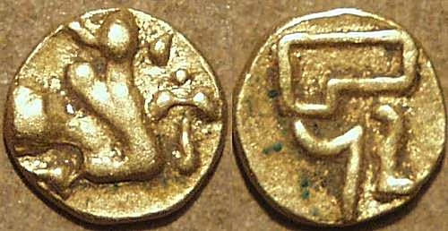
The Eastern Ganga currency consisted of gold fanams. Their obverse commonly depicted a couchant bull, while the reverse carried symbols including the letter sa, elephant goads, a battle axe, and a number representing the regnal year in the Anka system. Some coins carried the legend śrī rāma. The coins were similar in some respects to those of the Cholas and Eastern Chalukyas, reflecting the dynasty’s connections with southern India.
The Anka regnal system was distinctive. Its numerical notation used positional values in a way associated with the zero-place-holder system. The system remained in use in the Odia calendar and continued through the titular reign of the Gajapati Maharaja at Puri.
Cultural and Religious Geography
Shaivism and sacred landscapes
The early and later Eastern Gangas were strongly associated with Shaivism. The Mahendragiri region was particularly important in dynastic origin traditions. The family deity Gokarneswara, also called Gokarnaswamin, was worshipped on or near the mountain. According to the origin narrative, Kamarnava I worshipped this deity before establishing his authority in Kalinga.
Mukhalingam became a major centre of Eastern Ganga religious and architectural activity. The Madhukeswara or Madhukeshwara temple is associated with the Eastern Gangas and with the Eastern Kadamba connection. The temple’s architectural forms have been discussed in relation to Kadamba and Badami Chalukya traditions of Karnataka. These comparisons support cultural links across the Deccan, although they do not by themselves prove every detail of dynastic origin.
Other Shaiva monuments associated with the dynasty include the Chateswar Temple, Meghesvara Temple, and Nagnath Temple. The religious geography of the kingdom was therefore not limited to one royal shrine. Temples formed a network across the coastal and interior regions.
Vaishnavism and Puri
Anantavarman Chodaganga later embraced Srivaishnavism under the influence of Ramanuja and used the title Paramavaishnava in the Sindurapura grant. This did not erase the dynasty’s Shaiva associations. Instead, the royal religious landscape included multiple forms of Hindu patronage.
The Jagannath Temple at Puri became the most influential religious centre associated with the Eastern Ganga state. Its major construction is connected with Chodaganga’s reign. Puri’s importance lay in the combination of royal patronage, pilgrimage, ritual authority, and the political symbolism of the Jagannath cult. The map marks Puri as a religious and political centre rather than simply as a temple location.
Monumental architecture
The Konark Sun Temple was built under Narasimhadeva I. Its construction is associated with the king’s victories in Bengal and with the public expression of royal power. The monument occupies a position within a wider coastal sacred landscape that includes Puri, Bhubaneswar, Mukhalingam, and other temple centres.
The Ananta Vasudeva Temple at Bhubaneswar and the temples of Mukhalingam and Simhachalam further demonstrate the range of Eastern Ganga religious patronage. The Nrusinghanath Temple at Simhachalam in Andhra Pradesh is among the monuments remembered in connection with the dynasty. These sites connected regional traditions across Odisha and northern Andhra.
Language and court culture
Telugu served as an official language of the court during the early medieval period. As the empire expanded northward, Odia gained official status in the later medieval period after developing from Odra Prakrit. This change reflects the movement of the political centre into Odisha and the incorporation of local linguistic traditions into royal administration.
The map’s cultural boundaries should not be treated as sharp language borders. Telugu, Odia, and other regional speech communities interacted across the Kalinga and Odisha zones. Administrative usage, royal inscriptions, temple records, and local speech did not necessarily coincide.
Military Geography
The Ganga emperor was the supreme commander of the army and was assisted by a commander-in-chief. Military officers recorded in Ganga inscriptions included the Maha Senapati, Senapati, Maha Pasayati, Pasayati, Dalapati, and Nayaka. These titles indicate a developed military hierarchy, although the surviving record does not provide dependable totals for troop numbers.
The army included war elephants, which held particular symbolic and practical importance in eastern Indian warfare. Narasimhadeva I was the first Odisha ruler identified in the record as using the title Gajapati, lord of war elephants or king with an elephant army, in a 1246 CE inscription at the Kapilash Temple.
Southern and western theatres
The southern frontier around Visakhapatnam and Vengi was contested by the Cholas and the Eastern Gangas. The Cholas temporarily took territory during Chodaganga’s early reign, but the Ganga ruler recovered it. Marriage diplomacy followed earlier military conflict, showing that the southern frontier was managed through both warfare and dynastic alliance.
The western theatre centred on the Sambalpur–Bolangir tract. The Kalachuris of Ratnapura held this region for a period, and Kamarnava VII failed to capture it. Anangabhima III later succeeded in bringing the tract into the Ganga kingdom. Its location made it a strategic link between the coastal heartland and the western interior.
Northern campaigns
The northern campaigns of Chodaganga and Narasimhadeva I extended the dynasty’s influence toward Bengal. Chodaganga fought the Pala ruler Ramapala and pursued him toward the Ganga. Narasimhadeva I advanced into Radha and Varendra and reached Lakhnawati.
These operations were supported by the geography of the eastern plains, where river corridors and settlements facilitated movement but also exposed armies to counterattack. The map marks Lakhnawati and Varendra as campaign locations. It does not depict them as permanently incorporated provinces because the available evidence does not establish continuous Ganga administration there.
Defence and fortification
The Ganga empire contained many fortified cities, although the surviving information does not identify all of them or provide a systematic inventory. The kingdom’s defence depended on its depth from the coast, the Eastern Ghats, river crossings, regional governors, and the military capacity of the royal court. The royal navy added a maritime dimension under Chodaganga.
The dynasty defended its territory against repeated attacks from Muslim powers. The first reported invasion of Odisha by forces connected with Bakhtiyar Khalji ended without a successful conquest after Muhammad Sheran Khalji advanced toward Jajnagar and withdrew following Bakhtiyar’s death. Later, the Bengal governor Ghiyasuddin Iwaz Shah was repulsed during Anangabhima III’s reign. These episodes show that the northern frontier was an active military zone, not a stable line.
Political Geography
The Eastern Gangas interacted with several major powers:
- Somavanshis: The Gangas challenged and defeated Somavanshi rulers in northern Odisha. Control of Utkala became a central stage in the formation of the imperial kingdom.
- Cholas: The Cholas fought the Gangas in the southern coastal and Vengi regions. Conflict was followed by marriage alliances, including the marriage of Chola princess Rajasundari to an Eastern Ganga king.
- Kalachuris of Ratnapura: The Kalachuris contested the Sambalpur–Bolangir tract and remained important western rivals.
- Pala rulers: Chodaganga fought Ramapala and campaigned into the Bengal region.
- Bengal governors and sultanate forces: Bengal-based Muslim rulers attempted to invade Odisha. Some attacks were unsuccessful, while later powers such as Firuz Shah Tughlaq imposed tribute during the dynasty’s decline.
- Eastern Kadambas: These rulers served as feudatories, provincial governors, and allied chiefs. Their religious and dynastic connections linked Kalinga with Karnataka.
- Bhauma-Karas: Some early Ganga rulers acknowledged Bhauma-Kara authority, demonstrating that the dynasty’s early political position could be subordinate even when it retained local importance.
The political map therefore contains several kinds of relationship: direct royal administration, feudatory rule, military occupation, tribute, alliance, and contested influence. A single colour cannot fully represent these distinctions. The map’s core territory indicates the main zone of Ganga power, while campaign shading indicates areas reached by military expeditions or claimed through royal titulature.
Legacy and Decline
The Eastern Ganga imperial configuration developed over several centuries rather than appearing at one moment. Its early centre lay in southern Kalinga and northern Andhra. Under Vajrahasta V and Rajaraja Deva I, the dynasty challenged the Somavanshis and expanded northward. Anantavarman Chodaganga consolidated Kalinga, Utkala, and Kosala and established the political foundations of the imperial period. Anangabhima III defended the northern frontier and recovered the western Sambalpur–Bolangir tract. Narasimhadeva I carried Ganga power into Bengal and commemorated his victories through the Konark Sun Temple.
The dynasty’s decline began after Narasimhadeva I’s death in 1264 CE. External pressure increased, and the Delhi Sultanate invaded Odisha in the fourteenth century. Firuz Shah Tughlaq’s campaigns between 1353 and 1358 resulted in tribute being imposed on the Ganga ruler. The last known Eastern Ganga king, Narasimhadeva IV, ruled until 1425. Bhanu Deva IV followed him and remained on the throne until 1434, when the minister Kapilendra seized power and established the Suryavamsha dynasty.
The Ganga legacy continued through regional branches. The Paralakhemundi branch survived in Odisha, while related lines became associated with Badakhemundi, Sanakhemundi, Hindol, Bamanda, and Chikiti. The dynasty’s descendants remained connected with local states and zamindaris into the modern period. The Paralakhemundi line produced figures such as Krushna Chandra Gajapati, who played a major role in the formation of Odisha as a separate province in 1936.
The most enduring geographical legacy is visible in the temple landscape. Puri, Konark, Mukhalingam, Bhubaneswar, Simhachalam, and other centres preserve the relationship between political authority, religious patronage, and regional identity. The Eastern Ganga map is therefore not only a record of territorial expansion. It also shows how a dynasty rooted in Kalinga became a major power across Odisha and northern Andhra, connected coastal trade with inland administration, and used temples, inscriptions, titles, military campaigns, and changing capitals to express sovereignty.