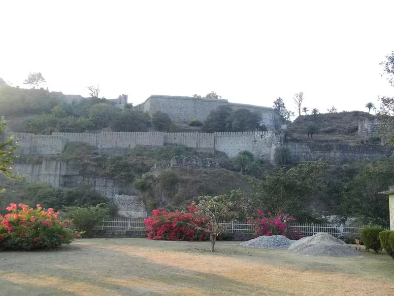
Overview
At an elevation of about 733 metres, Kangra stands where the Baner and Majhi rivers meet in the Himalayan foothills. Historically known as Nagarkot, the town developed around a powerful fort and wealthy temples controlled by the Katoch Rajputs. Its position made it both a religious centre and a prize in regional warfare.
Kangra’s history combines long-standing traditions with episodes that remain debated. It is associated with the ancient names Kiraj and Trigarta, and another traditional name, Bhimagar, is linked to Raja Bhim, said to have been a younger brother of Yudhishthira. Later centuries brought conflict involving Katoch rulers, Gurkha forces, Maharaja Ranjit Singh, the British, and others.
The town’s heritage was profoundly altered on 4 April 1905, when a major earthquake destroyed the fort, the town, and the temple of Devi Vajreshwari. The disaster killed 1,339 people in Kangra and about 20,000 elsewhere.
Etymology and Names
Kangra is also called Nagarkot. Older names connected with the town include Kiraj and Trigarta. The place was also known as Bhimagar, a name associated with the tradition that Raja Bhim founded it. This account belongs to the town’s historical and mythological memory rather than a securely dated foundation record.
The name Kangra has been connected with a Kangri word used in Ladakh and Lahaul for snow resting on mountain tops. Snow-capped peaks are visible from the town, making the interpretation especially suited to its landscape.
Geography and Location
Kangra lies in the Kangra Valley of present-day Himachal Pradesh. The town stands at the confluence of the Baner and Majhi rivers, while the Beas is another important river in the region. The surrounding Himalayan terrain gave Kangra both a distinctive setting and strategic value.
Its location connected the valley with wider routes across the western Himalaya. Trade links extended towards Ladakh and areas beyond the frontier. Geography also shaped the town’s economy: agriculture, tea cultivation, pastoral trade, and movement through mountain corridors all formed part of Kangra’s regional importance.
Ancient History
The Katoch Kshatriya Rajputs of the Chandravanshi lineage are traditionally credited with founding Kangra. Katoch rulers established a stronghold here, including a fort and lavish temples. The temple of Devi Vajreshwari became one of northern India’s oldest and wealthiest religious institutions.
Kangra’s ancient associations also include the name Trigarta and the tradition of Bhimagar. The available historical account does not provide a securely established foundation date, so these traditions should be distinguished from the better-documented political events of the medieval and early modern periods.
Historical Timeline
Medieval Period
A famous account states that Mahmud of Ghazni looted the Shri Bajreshwari Mata Mandir and a fort in the region in 1009. Whether the fort he attacked was Kangra Fort is not historically verified. The claim has been challenged because numerous well-defended forts lay between Ghazni and Nagarkot, making it uncertain that the expedition reached Kangra.
Other historians have argued that Kangra Fort remained unconquered until Emperor Jahangir’s conquest in 1622. This disagreement is central to understanding Kangra’s past: the story of a Ghaznavid raid is enduring, but the identification of the fort and the details of the event remain contested.
After Jahangir’s death, the Katoch kings recaptured the fort. Kangra then entered a period of conflict involving the Katochs and Maharaja Ranjit Singh, the Sikh emperor.
Katoch-Sikh and Gurkha Conflicts
During fighting between the Sikhs and Katochs, the gates of Kangra Fort were left open. In 1806, the Gurkha army entered Nagarkot Fort through those gates. This intervention forced the Katochs and Sikhs into an alliance. Their combined forces recaptured the fort after a battle in 1809.
Kangra remained with the Katoch kings until 1810, when Maharaja Ranjit Singh annexed it after the death of Sansar Chand Katoch. The episode demonstrates how control of the fort depended not only on siege warfare but also on alliances, timing, and access through its gates.
Colonial and Modern Era
The fort and city were captured by the British in 1846 and remained occupied until Indian independence. In 1855, the headquarters of the district were moved to Dharmsala, a cantonment established in 1849. This administrative shift reduced Kangra’s role as the principal district headquarters but did not erase its historical importance.
The earthquake of 4 April 1905 transformed the town’s physical heritage. Kangra Fort and the Vajreshwari temple were destroyed along with much of the town. In 1948, the princely state of Kangra was merged into India under Raja Druv Dev Chand Katoch, then titled Raja of Kangra-Lambagraon.
Religious and Cultural Importance
Kangra’s religious landscape includes the Vajreshwari tradition and several important temples in the wider region. These include Jawalaji, Chamunda Devi, Chintapurni, Baba Baroh, and Baijnath. The Kangra Śvetāmbara Jain Temple adds to the area’s religious diversity.
The region is also associated with the Masroor Rock Cut Temple, described as having a connection with the Pandavas and sometimes called the “Himalayan Pyramids.” These associations form part of the cultural traditions through which Kangra’s landscape is understood.
Economic Role
Tea cultivation was introduced into the Kangra Valley around 1850. The region also supported trade in rice, tea, potatoes, spices, wool, and honey. A government-established fair at Palampur sought to encourage commerce with Central Asia and attracted Yarkandi merchants.
The Lahulis carried goods towards Ladakh and territories beyond the frontier using pack sheep and goats. In the modern economy, Kangra has diversified beyond tea into tourism, agriculture, and professional services.
Monuments and Architecture
Kangra Fort remains the town’s defining heritage monument. It is described as one of India’s oldest forts and the oldest in Himachal Pradesh. Although damaged by the 1905 earthquake, it continues to represent the military and political history of Nagarkot.
Other attractions include the Masroor Rock Cut Temple, Gopalpur Nature Park with its tea gardens, and temples across the Kangra region. Dharamshala and nearby McLeodganj add further attractions, including the Bhagsunag Temple and the Himachal Pradesh Cricket Association Stadium, set against snow-capped mountains.
Modern City
The 2001 census recorded Kangra as an entirely urban settlement. One census account gives a population of 9,154, while a detailed table lists 10,185 people in 1,924 households. The same detailed figures record 7,567 literates and a sex ratio of 997.
Kangra is connected by road to cities in Himachal Pradesh and elsewhere in India. Kangra Airport lies about 10 kilometres north of the city, while the Kangra Valley Railway connects the area with Pathankot, about 94 kilometres away. Kangra is approximately 15 kilometres from Dharamshala and 36 kilometres from Palampur.