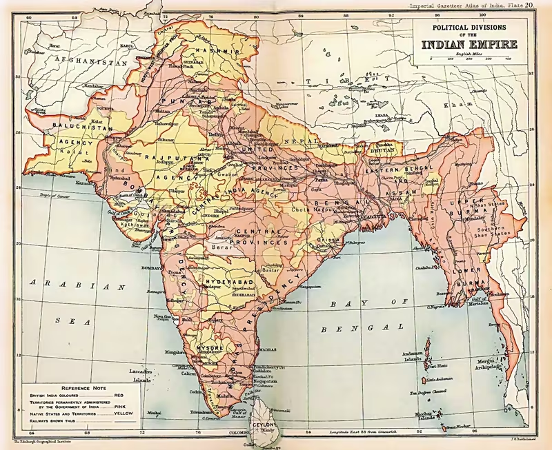
British Raj in 1947: A Map of Crown Rule, Provinces, and Princely States
Introduction
The map of the British Raj in 1947 was not a uniformly governed British possession. It brought together two distinct political spaces: British India, administered directly by the Crown through the viceroy and provincial governments, and the princely states, ruled by Indian princes whose external affairs, defence, and many communications were subject to British paramountcy. This layered geography defined the political landscape inherited by the new Dominions of India and Pakistan when British rule ended in August 1947.
The Raj formally began on 28 June 1858, after the Indian Rebellion of 1857 transferred authority from the East India Company to Queen Victoria. It lasted until the transfer of power in 1947. During those nine decades, the territory associated with British India changed repeatedly. Burma was incorporated in stages and separated from India in 1937; Aden was part of British India at the beginning of Crown rule but became a separate colony in 1937; Bengal was partitioned in 1905 and reunited in 1911; and the capital moved from Calcutta to Delhi in the same year. The final map was therefore the product of administrative reorganisation, imperial expansion, negotiated princely sovereignty, nationalist mobilisation, wartime pressures, and Partition.
The date represented here is 1947, the last year of the Raj. At that moment, the central government still operated through the viceroy and the Government of India, while provincial governments had gained substantial but limited autonomy under the Government of India Act 1935. The map also points toward the immediate future: the creation of India and Pakistan, the division of Punjab and Bengal, and the movement of millions of people across newly drawn borders.
Historical Context
From Company rule to Crown rule
British Crown rule followed the rebellion of 1857, which had challenged East India Company authority across important parts of northern India. The Government of India Act 1858 transferred the Company’s responsibilities to the British Crown in the person of Queen Victoria. Lord Canning became the first viceroy under the new arrangement. The change was institutional as well as symbolic. Government in India was reorganised through three levels: the India Office and the Secretary of State for India in London; the central government under the governor-general and viceroy; and the presidencies and provinces administered through governors, lieutenant-governors, or chief commissioners.
The Crown’s political settlement was more cautious than the expansionist programme associated with earlier Company rule. British officials sought closer communication between British and Indian subjects, reorganised the Indian army, and strengthened relationships with princes and large landholders. The princes and major landholders were regarded by Lord Canning as “breakwaters in a storm” because many had not joined the rebellion. Their territories were subsequently integrated into the political system of the Raj, with their positions and territories guaranteed under British paramountcy.
The new regime also reduced official enthusiasm for direct social intervention. Queen Victoria’s Proclamation declared that the Crown did not intend to impose its religious convictions on its Indian subjects. This policy did not end colonial intervention in administration, taxation, education, policing, or law, but it marked a change in the tone and declared objectives of government after 1857.
Administrative consolidation and territorial change
The second half of the nineteenth century saw a rapid consolidation of colonial administration. Railways, canals, roads, bridges, and telegraph lines connected the presidencies and inland districts. The government’s aim was administrative and strategic as well as economic. Railway lines allowed troops and officials to move more quickly, linked agricultural hinterlands with ports, and helped transport raw materials and finished goods.
The geographical scope of British India also changed. Lower Burma was already part of British India in 1858. Upper Burma was added in 1886, after which the territories were combined as Burma and administered as an autonomous province. Burma was separated from India in 1937 and became a separate Crown colony. Aden was part of British India from 1858 to 1937 and then became Aden Colony. British Somaliland was connected to British India briefly from 1884 to 1898.
Other territories occupied separate constitutional positions. Ceylon, now Sri Lanka, was ceded to Britain under the Treaty of Amiens in 1802. Its coastal regions had been temporarily administered through the Madras Presidency from 1793 to 1798, but Ceylon was not part of the British Raj. Nepal and Bhutan remained independent states after wars with Britain and subsequent treaties. Sikkim became a princely state after the Anglo-Sikkimese Treaty of 1861, although the question of sovereignty remained undefined. The Maldives were a British protectorate from 1887 to 1965, but were not part of British India.
Bengal, nationalism, and political reorganisation
In 1905, Viceroy Lord Curzon divided Bengal, the largest administrative subdivision in British India. The new arrangement created the Muslim-majority province of Eastern Bengal and Assam and the Hindu-majority province of West Bengal, which included areas corresponding to present-day West Bengal, Bihar, and Odisha. Curzon’s government presented the decision as an administrative measure, but it carried powerful communal and political consequences.
The partition provoked widespread protest, particularly among the Hindu middle classes of Bengal. The Swadeshi and boycott movements called for the rejection of British goods and the use of goods produced in India. The railway, postal, and press networks helped nationalist arguments circulate beyond Calcutta. Imports of British textiles fell during the boycott, while swadeshi cloth became a public expression of national pride despite being more expensive and less comfortable than Lancashire cloth.
The partition was annulled in 1911. Bengal was reunited, while new eastern provinces were organised as Assam, Bengal, Bihar, and Orissa. The same imperial announcement moved the capital from Calcutta to Delhi. This decision altered the political geography of the Raj. Calcutta remained a major port and eastern metropolis, but Delhi became the central seat of imperial authority.
From limited representation to mass politics
The expansion of political activity transformed the map from a record of imperial administration into a geography of organised nationalism. In 1885, professionals and intellectuals founded the Indian National Congress in Bombay. Initially, the Congress consisted largely of a Western-educated elite and concentrated on British policy, economic grievances, and representation. By the twentieth century, it developed into a wider political organisation.
The All-India Muslim League was founded in Dacca in December 1906 after Muslim leaders sought separate electorates and greater legislative representation. Its foundation followed the partition of Bengal, debates about representation, and anxieties among Muslim elites about political reforms that might favour the Hindu majority. In the early years, the League remained a relatively small organisation, but it expanded rapidly during the 1930s and 1940s.
The Morley–Minto Reforms of 1909 widened Indian participation in central and provincial legislatures while creating separate electorates for Muslims. The Lucknow Pact of 1916 brought the Congress and Muslim League together in a demand for greater self-government, while the Congress accepted separate Muslim electorates. This agreement temporarily aligned two political organisations but also institutionalised communal representation within the constitutional structure of the Raj.
War, reform, and confrontation
The First World War intensified demands for self-government. Approximately 1.4 million Indian and British soldiers of the British Indian Army served during the war, mainly in Iraq and the Middle East. India’s military contribution raised expectations that political participation would expand after the conflict.
In 1917, Secretary of State for India Edwin Montagu announced Britain’s aim of increasing Indian participation in administration and developing self-governing institutions. The Government of India Act 1919 introduced diarchy in the provinces. Indian ministers and legislatures received responsibility for areas such as education, agriculture, public health, infrastructure, and local self-government, while the governor and executive retained control over police, irrigation, land revenue, prisons, and other reserved subjects. Defence, foreign affairs, communications, criminal law, and income tax remained under the central government and viceroy.
At the same time, the colonial government retained wartime emergency powers. The Rowlatt Act of 1919 allowed detention without trial and special procedures for cases involving “anarchical and revolutionary movements.” Its passage generated widespread opposition. On 13 April 1919, troops commanded by Brigadier-General Reginald Dyer fired on an unarmed gathering at Jallianwala Bagh in Amritsar. The episode became a decisive symbol of colonial coercion and accelerated the movement against British rule.
Gandhi’s non-cooperation movement began in 1920. It called on Indians to return British honours, withdraw from government service, and boycott British goods. The Congress expanded its membership and moved toward mass politics. Although Gandhi suspended the movement in 1922 after violence at Chauri Chaura, civil disobedience resumed in later years. In 1930, the Salt Satyagraha challenged the colonial salt tax, linking a seemingly ordinary commodity to the wider geography of imperial law and economic control.
Provincial autonomy and the final decade
The Government of India Act 1935 created a new constitutional arrangement. It authorised independent legislative assemblies in all provinces of British India and provided for increased provincial autonomy. The Act also preserved separate representation for religious and social categories, including Muslims, Sikhs, Indian Christians, Anglo-Indians, Europeans, landholders, commerce and industry, and the Depressed Classes.
The 1937 elections gave the Congress victories in seven of the eleven provinces of British India. Congress ministries formed provincial governments with wide powers, although they remained within the constitutional framework of the Raj. Burma was separated from British India in 1937 and received a new constitution with a fully elected assembly.
The Second World War again altered the political geography. In 1939, Viceroy Lord Linlithgow declared India at war without consulting Indian leaders. Congress provincial ministries resigned in protest, while the Muslim League supported the British war effort and expanded its influence. In March 1940, the League adopted the Lahore Resolution, calling for Muslim-majority areas in the north-western and eastern zones of India to be grouped into independent states whose constituent units would be autonomous and sovereign.
Congress launched the Quit India Movement in 1942, demanding the immediate end of British rule. The Raj arrested Congress leaders and used the wartime army to suppress demonstrations. Subhas Chandra Bose, operating with Japanese support, organised the Indian National Army and the Provisional Government of Azad Hind. The Indian National Army’s military campaign failed, but the later trials of its officers generated public sympathy and nationalist feeling.
By 1946, mutinies in the Royal Indian Air Force and Royal Indian Navy, along with continuing political pressure, demonstrated the weakening of British authority. The Cabinet Mission attempted to negotiate a constitutional settlement, but disagreement between the Congress and Muslim League persisted. Direct Action Day, called by Muhammad Ali Jinnah on 16 August 1946, was followed by Hindu-Muslim violence in Calcutta and other parts of British India.
Britain announced in early 1947 that power would be transferred no later than June 1948. Lord Mountbatten advanced the date, and Partition created the Dominions of India and Pakistan in August 1947. The map of the Raj consequently became the starting point for two new states rather than a continuing imperial territory.
Territorial Extent and Boundaries
A layered political geography
The British Raj extended over most of the territories that now form India, Pakistan, Bangladesh, and Myanmar, although its exact extent varied by period. The map must therefore distinguish between territorial association and direct administration.
British India comprised the presidencies and provinces governed by the Crown through the central and provincial governments. The princely states were not part of British India in this strict administrative sense. They retained indigenous rulers and internal institutions, but their external affairs, defence, and much of their communications were controlled or supervised by Britain. The British Crown exercised paramountcy through the viceroy and through political agencies and residencies.
There were 565 princely states at independence. Their size and political weight varied enormously. Some were substantial territories with significant populations and administrative structures, while approximately 200 had areas smaller than 25 square kilometres. The larger states held treaties that specified the rights of their rulers; smaller states often possessed limited autonomy and relied heavily on British political supervision.
The northern frontier
The northern edge of the Raj was shaped by the Himalayas and the political geography of the Himalayan states. The mountains formed a major natural barrier, but they did not create a single uniform political boundary. Nepal and Bhutan were recognised as independent states after wars and treaties with Britain. Sikkim had a princely-state relationship with Britain after the Anglo-Sikkimese Treaty of 1861, though sovereignty remained undefined.
The north-western frontier was strategically significant because of its proximity to Afghanistan and the routes through which imperial armies and political movements could approach the subcontinent. The North-West Frontier Province was one of the provinces of British India by the final decades of the Raj. Punjab and the frontier regions were also important military recruiting grounds and areas of political tension.
The eastern frontier
The eastern side of the Raj extended toward Assam, Bengal, and Burma. Bengal’s position changed significantly after the partition of 1905 and its reversal in 1911. Assam became a separate province in the later administrative structure. Eastern Bengal and Assam had been created in 1905 as a Muslim-majority province, but the arrangement was dismantled when Bengal was reunited.
Burma formed part of British India in stages. Lower Burma was already included when Crown rule began in 1858, while Upper Burma was added in 1886. Burma was administered as an autonomous province until 1937, when it became a separate Crown colony. Thus, a map of the Raj at its beginning may include Burma within the Indian administrative framework, while a map of 1947 must show it separately.
The southern and maritime frontier
The southern boundary of British India was defined by the Indian Ocean and the long coastlines of the subcontinent. The presidencies of Madras and Bombay were major administrative and maritime centres. Ports such as Bombay, Madras, Calcutta, and Karachi connected the interior with overseas markets and imperial shipping routes.
Ceylon occupied a separate constitutional position. Although connected historically and economically to southern India, it was not part of the Raj. The Maldives were a British protectorate but not part of British India. These distinctions are important because imperial maps often grouped territories by strategic or commercial association even when their legal status differed.
Western and overseas connections
The western frontier reached toward Baluchistan, Sind, Punjab, and the Arabian Sea. British Baluchistan, Sind, and the North-West Frontier Province formed part of the later provincial structure. Karachi was an important port for the movement of troops, grain, and wartime supplies.
Beyond the subcontinent, Aden was part of British India from 1858 to 1937 before becoming Aden Colony. British Somaliland was briefly associated with British India from 1884 to 1898. The Trucial States of the Persian Gulf developed closer relationships with the Government of the British Raj in the early twentieth century, in a manner compared with the relationship between Britain and the princely states, but they were not incorporated into British India in the same way.
Direct control, paramountcy, and independence
The political map cannot be read as a simple division between British and non-British territory. British India was governed through laws passed by the British Parliament and the legislative powers delegated to central and provincial governments. The courts of the princely states operated under the authority of their respective rulers.
The princes were therefore neither fully sovereign in the international sense nor ordinary provincial officials. Britain controlled external affairs, defence, and communications while exercising influence over internal politics, including the recognition of rulers. The final political crisis of 1947 required the settlement of both directly governed provinces and princely states, making the distinction central to the postcolonial map.
Administrative Structure
The India Office and the central government
After 1858, the Secretary of State for India in London directed imperial policy. The Secretary of State was assisted by the Council of India, whose members were required to have substantial experience in India. The original structure was described as a system of “double government”: the Secretary of State issued instructions from London, while the council was intended to provide expertise and act as a check on policy.
In practice, the Secretary of State possessed emergency powers and could make decisions without the council. Indian revenues, administrative policy, and the operation of the colonial state were therefore closely connected to decision-making in London. The Government of India in Calcutta, and later Delhi, implemented central policy across British India.
The governor-general became more commonly known as the viceroy because he represented the Crown in relations with the princely states. This dual role made the viceroy both the head of the central government and the Crown’s representative to rulers who were nominally sovereign within their own territories.
The portfolio system and executive government
Following the rebellion, Viceroy Lord Canning introduced a portfolio system. Each department of government was assigned to a member of the Executive Council, who became responsible for routine decisions in that field. Major decisions continued to require the consent of the governor-general and, where necessary, discussion by the full Executive Council.
The Indian Councils Act 1861 expanded the Legislative Council by adding appointed members. Some were Indian and some were domiciled Britons in India, but their role was initially advisory and their representation was limited. Legislative participation expanded over time through the Indian Councils Act 1892, the Morley–Minto Reforms of 1909, and the Montagu–Chelmsford reforms of 1919.
By the final period of the Raj, the viceroy headed a central administration with departments for defence, foreign affairs, finance, communications, and other areas. The central legislature consisted of the Council of State and the Legislative Assembly. The viceroy could override the legislature and enact measures in what he regarded as the interests of British India.
Presidencies and provinces
At the turn of the twentieth century, British India included eight major provinces administered by governors or lieutenant-governors. The administrative map was later reorganised. By 1937, British India consisted of 17 administrations:
- Madras Presidency
- Bombay Presidency
- Bengal
- United Provinces
- Punjab
- Bihar
- Central Provinces and Berar
- Assam
- North-West Frontier Province
- Orissa
- Sind
- British Baluchistan
- Delhi
- Ajmer-Merwara
- Coorg
- Andaman and Nicobar Islands
- Panth Piploda
The presidencies and the first group of major provinces had governors, while several smaller territories were administered by chief commissioners. Provinces were divided into divisions, each headed by a commissioner, and then into districts. Districts were the basic units of colonial administration and were managed by officials such as district magistrates, collectors, or deputy commissioners.
In 1947, British India contained 230 districts. These districts were responsible for revenue collection, policing, courts, public works, and the implementation of central and provincial policies. Their boundaries and administrative practices had a direct impact on the experience of colonial rule in rural society.
Provincial autonomy after 1935
The Government of India Act 1935 increased provincial autonomy and allowed elected ministries to exercise authority over a wider range of subjects. The 1937 elections brought Congress governments to power in seven of the eleven provinces. Provincial legislatures could address matters such as education, agriculture, public health, land revenue, infrastructure, and local self-government, though governors retained substantial powers.
The Act divided the electorate into 19 religious and social categories. Separate representation was provided for Muslims, Sikhs, Indian Christians, Anglo-Indians, Europeans, landholders, commerce and industry, and other designated groups. This structure expanded participation but also reinforced political identities organised around community and interest.
Princely states and political agencies
The princely states were grouped into agencies and residencies. British political officers supervised relations between the rulers and the Crown. The states retained their own courts and internal administrations, but Britain could influence succession, recognition, diplomacy, military arrangements, and political conduct.
The relationship varied from state to state. Larger princes possessed treaties defining their rights, while smaller rulers exercised fewer independent powers. The state system allowed Britain to govern a vast territory without replacing every local dynasty, but it also left the subcontinent politically fragmented. In 1947, the future of these states became one of the major constitutional questions created by the end of paramountcy.
Infrastructure and Communications
Railways
The railway was the most visible element of the Raj’s infrastructural geography. Construction began before the Crown assumed direct rule, but expanded rapidly in the decades after 1858. The Great Indian Peninsular Railway and the East Indian Railway Company began constructing lines near Bombay and Calcutta in 1853–54. The first passenger railway line in northern India, between Allahabad and Kanpur, opened in 1859.
Governor-General Lord Dalhousie had formulated a plan for trunk lines connecting the principal regions of India. Government guarantees attracted private investment, with companies receiving land and assured returns during the early years of operation. By 1890, route mileage had increased from 1,349 kilometres in 1860 to 25,495 kilometres. Lines radiated inland from Bombay, Madras, and Calcutta and connected the major ports with agricultural and commercial regions.
By 1900, India possessed railway systems using broad, metre, and narrow gauges. Several princely states built their own lines, extending the network into regions corresponding to modern Assam, Rajasthan, and Andhra Pradesh. The railway system was not simply an economic network. Colonial authorities considered it a strategic instrument for moving troops, suppressing unrest, protecting European populations, and administering distant districts.
The railway economy also reflected the unequal structure of colonial rule. European engineers, supervisors, and operating personnel dominated higher positions for much of the Raj, while Indians performed most unskilled physical labour. Railway companies purchased much of their hardware and spare parts from Britain, and contracts were often channelled through the India Office in London, restricting opportunities for Indian firms.
During the First World War, railways carried troops and grain to Bombay and Karachi for onward movement to Britain, Mesopotamia, and East Africa. Increased demand and shortages of equipment strained the system. Some workshops were converted to munitions production, and locomotives, rolling stock, and track were sent to the Middle East. By the end of the war, maintenance had deteriorated and the railways were no longer profitable. The government nationalised the Great Indian Peninsular Railway and East Indian Railway in 1923.
Telegraphs, roads, and administrative communication
Telegraph links were rapidly established alongside railways. The telegraph allowed the central government to communicate with provincial capitals, military commands, ports, and district administrations. It reduced the time required to transmit orders across the subcontinent and strengthened the centralising capacity of the Raj.
Roads and bridges supported railway construction, military movement, postal services, and the transport of agricultural goods. Canals and irrigation works also functioned as communication and administrative infrastructure. The infrastructure map was therefore closely tied to the political map: routes connected the central government to provincial offices, commercial ports, military stations, and revenue districts.
Canals and irrigation
The Raj invested heavily in irrigation. The Ganges Canal extended approximately 560 kilometres from Haridwar to Cawnpore, now Kanpur, and supplied thousands of kilometres of distribution canals. By 1900, British India possessed what was described as the largest irrigation system in the world.
Irrigation transformed parts of the agricultural geography. Commercial cropping expanded in regions such as Punjab, and the amount of irrigated land increased eightfold. Assam, described as a jungle in 1840, had approximately 1.6 million hectares under cultivation by 1900, particularly in tea plantations.
The benefits were uneven. Irrigation could increase production and improve the position of some peasant communities, but it also promoted cash crops and tied agricultural regions to distant markets. The infrastructure was funded largely through public revenue, and farmers and labourers bore much of the financial risk associated with colonial development.
Maritime connections
The major ports—Bombay, Madras, Calcutta, and Karachi—were the principal maritime gateways of the Raj. Cotton from inland regions moved toward Bombay for export to England, while British manufactured goods returned through the same commercial system for sale in Indian markets. During the First World War, Bombay and Karachi became major departure points for troops and grain.
The long coastline of British India connected the subcontinent to Britain, the Middle East, East Africa, and Southeast Asia. Ports were therefore economic, military, and administrative nodes. Their importance is reflected in the railway pattern, which largely radiated inland from the principal coastal cities.
Economic Geography
Agriculture and export regions
Agriculture remained the dominant sector of the economy. Irrigation, railways, and global markets encouraged the production of export crops and raw materials, including cotton, jute, sugarcane, coffee, and tea. The Punjab’s canal networks supported commercial agriculture, while Assam became a major tea-producing region.
The integration of agricultural districts with distant markets created new opportunities but also new vulnerabilities. By the late nineteenth century, a large share of some raw materials and food grains was exported. Small farmers dependent on fluctuating markets could lose land, animals, and equipment to moneylenders. The same railway lines that moved famine relief could also move grain away from areas experiencing scarcity.
The Great Famine of 1876–78 caused between 6.1 million and 10.39 million deaths according to the estimates cited in the historical record. The famine of 1899–1900 caused between 1.25 million and 10 million deaths. Critics in Britain and India blamed colonial policies, export practices, and administrative failures. After the famine of 1876–78, the Indian Famine Commission report of 1880 led to the creation of Famine Codes and famine-prevention programmes.
Textiles and deindustrialisation
The colonial trade system reshaped India’s textile geography. Imports of British manufactured cotton cloth rose from approximately one million yards in 1814 to 13 million yards in 1820, 995 million yards in 1870, and 2.05 billion yards in 1890. By 1870–80, Indian producers manufactured only 25%–45% of local consumption.
British manufactured goods entered India under a free-trade system, while continental Europe and the United States maintained high tariff barriers against Indian goods. The result was a severe contraction of important indigenous industries, including textile production and ironworking. The economic effects of British rule remain debated. Nationalist historians emphasised impoverishment, unequal trade, and the drain of wealth, while other historians have argued that British rule continued and redirected economic processes already shaped by regional Indian elites and institutions.
Indian industrial enterprise
Industrial development did occur within the colonial economy, although it was uneven and constrained. Jamsetji Tata established the Central India Spinning, Weaving, and Manufacturing Company in Bombay in 1877. He attempted to compete with British imports by using longer-stapled Egyptian cotton and more advanced ring-spindle machinery from the United States.
The Tata group later moved into heavy industry. Tata Iron and Steel Company began constructing its plant at Jamshedpur in Bihar in 1908, using American technology and Indian capital. The company became a leading iron and steel producer and a symbol of Indian technical and managerial capacity.
During the Second World War, production expanded sharply because British spending on uniforms, rifles, machine-guns, field artillery, ammunition, and other supplies increased. Industrial output rose in textiles, steel, and chemicals. The war strengthened some industrial sectors even as it placed extraordinary pressure on railways, food supplies, and public administration.
Revenue and the rural state
The colonial state depended heavily on land revenue. Collection became more difficult after 1919, and the expansion of civil disobedience weakened the authority of revenue agents. In the 1930s, confiscated land had to be returned after Congress-controlled provincial governments took office. During the Second World War, revenue collectors again relied on military force, particularly when the Quit India Movement disrupted administration.
The economic map was therefore also a map of state power. District collectors, irrigation departments, railways, police stations, courts, and agricultural offices connected rural communities to the central and provincial governments. These institutions enabled the state to extract revenue and regulate production, but they also became targets of nationalist protest.
Ports and commercial centres
Bombay was the principal western commercial and industrial centre, especially for cotton. Calcutta was the major eastern port and the political capital until 1911. Madras served as the principal administrative and commercial centre of the south. Karachi was important for military and commercial traffic, particularly during the First World War. Dacca was an important eastern political centre, especially in the history of the Muslim League and the partition of Bengal.
The economic system linked these ports with inland railway corridors, canal-irrigated agricultural districts, plantation regions, mining and industrial centres, and military stations. The map’s routes therefore represent more than transport: they show the spatial structure of colonial extraction, commerce, state control, and industrial change.
Cultural and Religious Geography
Linguistic and regional diversity
The Raj encompassed a highly diverse population distributed across Himalayan mountains, floodplains, plateaus, forests, deserts, and coastal regions. British administration divided this diversity into provinces, districts, census categories, and electorates. These categories were administrative tools, but they also influenced political identities.
English became central to higher education and public administration. Universities were established at Calcutta, Bombay, and Madras in 1857, and the colonial state expanded colleges and educational institutions. By 1911, it had opened 186 universities and colleges of higher education, enrolling approximately 36,000 students. By 1939, the number of institutions had doubled and enrolment had reached about 145,000, although more than 90% of students were men.
The educational curriculum followed British models and emphasised English literature and European history. By the 1920s, student bodies had become important centres of Indian nationalism. Education created a professional middle class that entered the civil service, law, journalism, political associations, and reform movements.
Hindu, Muslim, Sikh, and other communities
Religious geography shaped the constitutional and political map of the Raj. The population was overwhelmingly diverse in religious composition, with Hindu, Muslim, Sikh, Christian, and other communities distributed unevenly across provinces and princely states.
The 1871 Census of British India provided new estimates of population by religious community. These figures influenced political calculations among Muslim and Hindu leaders. Muslim elites in northern India feared that representative reforms could produce permanent Hindu-majority control. Hindu political organisations, including the Arya Samaj and Cow Protection Societies, contributed to communal mobilisation in some regions.
The partition of Bengal, the separate electorates introduced by the Morley–Minto Reforms, and the communal representation reaffirmed by the Government of India Act 1919 and the Act of 1935 all made religion an explicit element of political geography. Muslim electorates included representation in provincial and central legislatures, while seats were also reserved for Sikhs, Indian Christians, Anglo-Indians, and Europeans.
Punjab had a distinctive religious geography, with large Sikh, Muslim, and Hindu populations. Bengal also contained substantial Hindu and Muslim populations distributed across different regions. These patterns became especially significant during Partition, when the new borders divided communities, political constituencies, and agricultural regions.
Reform movements and social change
After 1857, official British social intervention became more cautious, particularly in matters relating to religion. Indian reform movements nevertheless continued. Pandita Ramabai advocated women’s emancipation and widow remarriage, while Gopal Krishna Gokhale founded the Servants of India Society, which promoted legislative reform and worked among communities treated as untouchable.
Gandhi’s political programme connected religious and social questions with the idea of swaraj. In Hind Swaraj, he emphasised solidarity between Hindus and Muslims, the removal of untouchability, and swadeshi. These principles linked social reform, economic self-reliance, and political independence.
The map of cultural geography was thus not static. Urban centres such as Bombay, Calcutta, Madras, Delhi, Lahore, and Dacca connected regional languages and communities through newspapers, universities, political meetings, railways, and public associations. Nationalist politics spread through these networks while also encountering powerful local and religious identities.
Health, epidemics, and public institutions
Public health formed another layer of the colonial map. India experienced major epidemics and famines during the Raj. The first cholera pandemic began in Bengal and spread across India after 1820. The third plague pandemic eventually killed approximately 10 million people in India alone. Fevers and malaria were leading causes of death.
Ronald Ross demonstrated in 1898 that mosquitoes transmit malaria while working in India. Waldemar Haffkine developed and deployed vaccines against cholera and bubonic plague, and the Plague Laboratory in Bombay was renamed the Haffkine Institute in 1925. Smallpox vaccination expanded during the nineteenth century and contributed to a major decline in smallpox mortality by the end of the century.
Medical colleges and institutions also reflected the geography of colonial education. Grant Medical College in Bombay became one of the recognised institutions teaching courses leading to degrees. These institutions trained a limited but growing group of Indian medical professionals and connected major cities to emerging public-health systems.
Monuments and antiquarian administration
The colonial state also mapped and preserved antiquities. Lord Curzon’s programme included archaeological research and the preservation of monuments. The preservation of antiquities served scholarly, administrative, and imperial purposes, presenting India’s past as an object of systematic study while placing historic sites within the framework of colonial governance.
The record available for this map does not identify a complete list of monuments or securely located sacred centres. The most important cultural geography represented here is therefore institutional and political: universities, cities, press networks, reform organisations, legislative centres, and the religiously defined electorates that shaped late colonial politics.
Military Geography
Reorganisation after 1857
The rebellion of 1857 profoundly influenced the military geography of the Raj. Units composed of Muslims and Brahmins from the United Provinces of Agra and Oudh, who had formed the core of the rebellion, were disbanded. New regiments were recruited from communities that British officials regarded as loyal, including Sikhs and Baluchis.
The reorganisation aimed to prevent the concentration of military power among a single regional or social group. The Indian army remained substantially unchanged in its organisation until 1947. In 1880, the standing Indian Army included approximately 66,000 British soldiers, 130,000 Indian troops, and 350,000 soldiers in the armies of the princely states.
The army’s distribution followed the strategic geography of the Raj. Punjab, the north-western frontier, the major presidencies, and key railway corridors were particularly important. Railways allowed the government to shift troops rapidly between garrisons and areas of unrest.
Frontier defence
The north-western frontier was among the most strategically sensitive regions. The proximity of Afghanistan and the routes through the mountain passes made Punjab, the North-West Frontier Province, and British Baluchistan central to imperial defence. Military administration in these regions was closely linked to political agencies, roads, telegraph lines, and railway development.
The colonial state also maintained relations with Nepal and Bhutan, which were independent states under treaty relationships with Britain. The Himalayan region was therefore a zone of diplomatic and military concern rather than a simple line of direct administration.
Imperial campaigns
Indian troops participated in imperial campaigns beyond the subcontinent. The Second Anglo-Afghan War was among the campaigns that influenced political attitudes in India. During the First World War, approximately 1.4 million Indian and British soldiers of the British Indian Army served, primarily in Iraq and the Middle East. During the war, Bombay and Karachi became major embarkation ports for troops and grain.
The war also exposed the military dependence of the imperial system. With much of the British army reassigned to Europe and Mesopotamia, officials worried about the risks of reducing the garrison in India. This concern helped produce the Defence of India Act 1915, which expanded the state’s power to detain political suspects and control the press.
Nationalist military challenges
The revolutionary movement included groups in Bengal, the Bombay Presidency, and Punjab. The Government of India responded with surveillance, emergency powers, censorship, and imprisonment. The Rowlatt Committee later identified Bengal, Bombay, and Punjab as regions of conspiratorial insurgency.
Subhas Chandra Bose created the Indian National Army with Japanese support during the Second World War. It was composed largely of Indian soldiers captured by the Japanese at Singapore. The INA fought alongside Japanese forces during the U-Go offensive and the Burma Campaign. Its forces largely disintegrated after the British halted and reversed the Japanese advance in Burma, and remaining elements surrendered after the recapture of Singapore in September 1945.
Although the INA did not defeat British forces, its existence challenged the loyalty of Indian soldiers and became politically influential during the trials of its officers. Public sympathy for the INA contributed to the wider crisis of imperial authority after the war.
Mutinies and the end of imperial control
In 1946, mutinies began among Royal Indian Air Force personnel frustrated by delays in repatriation. The Royal Indian Navy mutiny in Bombay in February spread to Calcutta, Madras, and Karachi. The mutinies were suppressed, but they demonstrated that the British could no longer rely upon unquestioned loyalty within the armed services.
The wartime expansion of the Indian army had created a massive force. At the same time, the cost of maintaining the imperial system and the political impact of nationalist movements made continued control increasingly difficult. By 1946–47, direct British authority was rapidly disappearing in parts of the countryside, and the military geography of the Raj was becoming inseparable from the political question of withdrawal.
Political Geography
The Congress and the Muslim League
The late colonial political map was shaped by the competing organisational geographies of the Indian National Congress and the All-India Muslim League. The Congress developed from an urban, educated elite into a mass movement with provincial and district networks. The Muslim League initially had limited membership but expanded rapidly after the 1930s by presenting itself as the principal representative of Muslim political interests.
The two organisations sometimes cooperated. The Lucknow Pact of 1916 united them in a demand for greater self-government, while the Congress accepted separate electorates for Muslims. Their relationship later deteriorated as the political stakes of majority and minority representation became more urgent.
The Congress described India as a natural unity and opposed the creation of a religious state. Muhammad Ali Jinnah argued instead that Hindus and Muslims constituted distinct social orders and nations. The League’s Lahore Resolution of 1940 demanded that Muslim-majority areas in the north-western and eastern zones be grouped into independent states with autonomous and sovereign constituent units.
Princely states and paramountcy
The princely states formed a parallel political system. Their rulers were linked to Britain through treaties, subsidiary alliances, political agencies, and residencies. The British Crown guaranteed territories and recognised rulers, while retaining control over defence and foreign relations.
The states’ position created a complex political geography. A province under direct British administration could border a princely state with its own court, revenue arrangements, and ruler. Railways and communications often crossed these political divisions. The central government dealt with the states through the viceroy’s role as Crown representative, while provincial authorities managed relations with smaller states under their jurisdiction.
At independence, the end of British paramountcy left the princely states facing a new constitutional order. The map of 1947 therefore included territories whose future relationship with India or Pakistan had not been resolved by the same process as the directly governed provinces.
Burma, Ceylon, Nepal, Bhutan, and the Maldives
The political geography of the Raj extended beyond the core provinces through different forms of association. Burma was part of British India until its separation in 1937. Aden was part of British India from 1858 to 1937. British Somaliland was connected briefly to the Indian administration.
Ceylon was a British possession but not part of British India. Nepal and Bhutan were independent states under treaty relationships with Britain. Sikkim occupied a distinct position as a princely state whose sovereignty remained undefined. The Maldives were a British protectorate but not part of British India.
These distinctions matter for map interpretation. Imperial maps could show connected zones of influence and administration without implying identical sovereignty or legal status.
War and constitutional negotiation
The Second World War intensified political divisions. The viceroy’s decision to declare India at war without consulting Indian leaders caused Congress ministries to resign. The Muslim League supported the British war effort and used the political opening to expand its influence in Bengal, Sind, and Punjab, among other regions.
The Cripps Mission of 1942 offered the possibility of independence after the war in exchange for nationalist cooperation, but negotiations with Congress failed. The Quit India Movement led to mass arrests and demonstrations, while the League continued to negotiate from a position of growing strength.
After the war, the Cabinet Mission attempted to create a constitutional arrangement that could hold together India’s provinces and political communities. Disagreement over the distribution of power and the future of Muslim-majority areas prevented a settlement. Communal violence in Calcutta, Punjab, Bengal, and other regions made territorial separation increasingly likely.
Partition and the 1947 map
The transfer of power created two Dominions: Pakistan, with Muhammad Ali Jinnah as governor-general, and India, with Jawaharlal Nehru as prime minister and Louis Mountbatten as the first governor-general. Official ceremonies took place in Karachi on 14 August and New Delhi on 15 August 1947.
The new boundary divided Punjab and Bengal, two provinces with complex religious and regional populations. Millions of Hindus, Muslims, and Sikhs moved across the borders. Between approximately 250,000 and 500,000 people died in the violence among refugee and resident populations, according to the figures cited in the historical record.
Partition transformed administrative boundaries into international frontiers. Railways, roads, irrigation canals, cities, villages, and military districts were divided or redirected. The map of the Raj ceased to be an imperial map and became the foundation for the territorial politics of India, Pakistan, and later Bangladesh.
Legacy and Decline
The end of the Raj
The British Raj lasted from 1858 to 1947. Its end resulted from the combined effects of nationalist mobilisation, constitutional reform, wartime exhaustion, economic pressure, communal conflict, and the weakening reliability of colonial institutions. The British Labour government recognised that it lacked the domestic mandate, international support, and dependable forces necessary to continue ruling an increasingly restless India.
The final years were marked by administrative contraction. Provincial governments increasingly challenged colonial authority, revenue collection became difficult, the Quit India Movement disrupted local administration, and military mutinies demonstrated the uncertainty of imperial control. The transfer of power was consequently accelerated, leaving less than six months for a mutually agreed plan for independence after Mountbatten’s arrival as viceroy.
Administrative inheritance
Independent India inherited much of the administrative framework built under the Raj: provinces and districts, civil services, railways, irrigation departments, courts, universities, ports, and telegraph and communications systems. Pakistan inherited parts of the same institutional structure in the territories that formed its new state.
The Government of India Act 1935 influenced the Constitution of independent India. Its provincial arrangements, legislative practices, and administrative divisions provided a framework that could be adapted after independence, even though the political principles of colonial rule were rejected.
The railways were amalgamated after independence. Forty-two separate systems, including 32 lines owned by former princely states, were combined to form a single nationalised unit named Indian Railways. The network created under colonial rule thus became a central institution of the postcolonial state, even though its original purposes included military control and imperial commerce.
Economic and social legacies
The economic legacy of the Raj remains debated. Colonial rule connected India to world markets, expanded railways and irrigation, and supported selected industrial enterprises. It also promoted exports of raw materials, encouraged dependence on fluctuating international markets, weakened important indigenous industries, and placed much of the financial burden of infrastructure on Indian taxpayers.
Agriculture remained dominant, and per capita income did not show long-term improvement during the colonial period according to the historical account. India’s share of global GDP fell from above 20% to less than 5% during the colonial period. Historians continue to disagree about the balance between inherited regional economic structures, British policy, Indian elite cooperation, imperial extraction, and industrial change.
Socially, the Raj created new educational and professional groups while maintaining extensive inequalities. Universities, colleges, medical institutions, newspapers, legislatures, and political associations helped produce the leadership of the independence movement. At the same time, colonial census categories and constitutional arrangements made religious and social identities more prominent in political representation.
The enduring importance of the 1947 map
The 1947 map is significant because it captures a political system in transition. It shows that the Raj was not simply a continuous block of British territory. It was a layered structure composed of directly governed provinces, princely states, autonomous or separate colonies, independent treaty states, protectorates, military frontiers, ports, railway corridors, and commercial regions.
Its boundaries were not permanent. Bengal changed shape; Burma moved from an Indian province to a separate colony; Aden left the Indian framework; the capital moved from Calcutta to Delhi; and the princely states remained constitutionally distinct until the end of paramountcy. The final transformation came with Partition, when the imperial administrative map was replaced by the territories of India and Pakistan.
For historical map reading, the central lesson is that political control, legal sovereignty, economic integration, and cultural geography did not coincide. A region could be connected to British India by railway, trade, or military policy without being directly administered by the Crown. A princely state could retain a hereditary ruler while remaining dependent on British protection. A province could gain elected ministers while the viceroy retained decisive powers. The map of the British Raj is therefore best understood as a geography of layered authority, changing boundaries, and contested political futures.