Overview
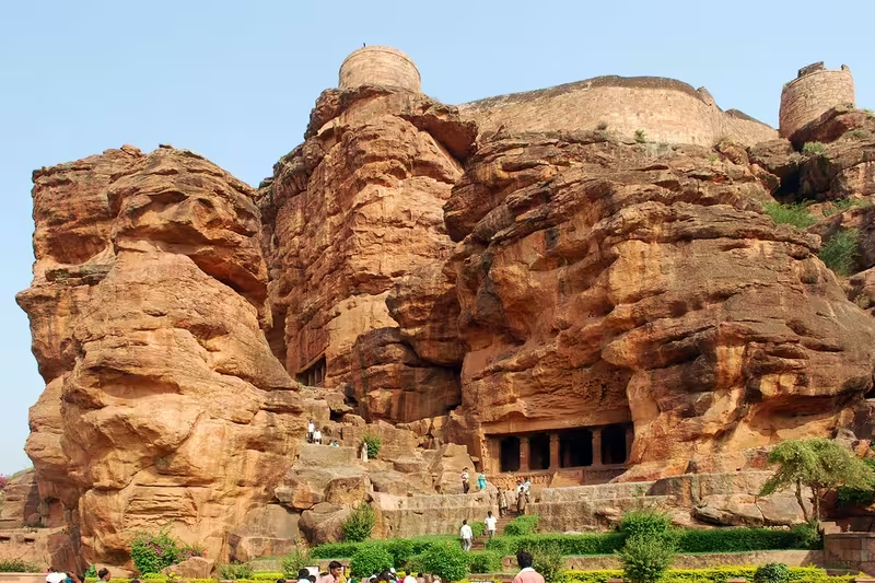
At the foot of rugged red sandstone hills, the town of Badami occupies a ravine wrapped around the waters of Agastya Lake. Known in earlier centuries as Vatapi, it became the regal capital of the Badami Chalukyas in 540 CE and remained their political centre until 757. The landscape explains much of its early importance: cliffs protect the settlement on three sides, while the lake supplied water to the capital and the religious buildings that grew around it.
Badami is best known for its rock-cut cave temples, but its historical landscape is broader. Structural shrines such as the Bhutanatha temples, Badami Shivalaya, and Jambulingesvara Temple stand alongside fortifications, inscriptions, murals, and later monuments. Together with Aihole, Pattadakal, and Mahakuta, Badami belongs to the Malprabha valley, a region where Hindu and Jain architectural traditions developed in particularly influential forms.
The surviving remains also record periods of destruction, rebuilding, and political change. Pallava armies captured Vatapi in 642, later rulers added temples and fortifications, and the area was contested by Vijayanagara monarchs and the Deccan sultanates. Today, Badami is the headquarters of its taluk in Bagalkot district and has been selected as a heritage city under the Government of India's HRIDAY scheme.
Etymology and Names
The town is now called Badami, while its best-known historical name was Vatapi, also written Vātāpi. The Sanskrit explanation connects the name with āpi, meaning “friend” or “ally,” and with the idea of having the wind, vāta, as an ally. Historical inscriptions use the older name.
The earliest major inscription at the site dates to 543 CE and belongs to Pulakeshin I, whose name is also given as Vallabheswara. Engraved on a hillock, it records the fortification of the hill above Vatapi. A later inscription from 578 CE, associated with Mangalesha, is written in the Kannada language and script. These records help connect the physical remains with the rulers who developed the capital.
Geography and Location
Badami lies at 15.92°N and 75.68°E, at an average elevation of 586 metres. The town covers approximately 10.3 square kilometres. It is positioned at the mouth of a ravine between rocky hills, with Agastya Lake occupying the basin on the other sides. The surrounding red sandstone outcrops are both a defining visual feature and an important historical resource: they provided defensible high ground and material for excavated monuments.
Agastya Lake, formerly called Vatapi Lake, was a man-made water project completed in the seventh century. It probably served as a strategic source of water for the capital. Temples were constructed around it, making the reservoir a central element of Badami's political, architectural, and sacred landscape.
Badami is 30 kilometres from Bagalkot, 46 kilometres from Aihole, 128 kilometres from Bijapur, 132 kilometres from Hubli, and 589 kilometres from Bengaluru. Summers extend from March to June, with temperatures ranging from about 22°C to 40°C. The monsoon season generally lasts from July to October, while winter runs from November to February. Average annual rainfall is around 680 millimetres. November to March is regarded as the most comfortable period for visiting.
Ancient History
The history preserved in Badami's monuments begins prominently with the rise of the Badami Chalukyas. Pulakeshin I is generally regarded as the founder of the dynasty in 540. His decision to establish the capital at Vatapi was likely strategic. Rugged sandstone cliffs protected the settlement on three sides, and the fortified hill gave the rulers a defensible position.
Pulakeshin I's son Kirtivarman I strengthened Vatapi. After Kirtivarman's death, his brother Mangalesha governed while Kirtivarman's sons were still minors. The Mahakuta Pillar inscription records this period of rule. Kirtivarman and Mangalesha are associated with the construction of Badami's cave temples, which became among the clearest expressions of the new Chalukya architectural culture.
Historical Timeline
Badami Chalukya Period
Vatapi was the capital of a kingdom that, between the sixth and eighth centuries, ruled much of Karnataka, Maharashtra, and parts of Tamil Nadu and Andhra Pradesh. Under the Chalukyas, Badami became a regional centre of art and architecture. The temple builders of the Malprabha valley experimented with both Dravida and Nagara forms, producing a varied architectural tradition visible across Badami and its neighbouring sites.
Pulakeshin II came to power in 610 and ruled until 642. His reign is remembered as one of the most important phases of Chalukya power. The city accumulated wealth and monumental works during this period, but its prominence also made it a target.
Pallava Capture of Vatapi
In 642, Pulakeshin II was defeated by Narasimhavarman of the Pallavas. The Pallava army descended on Vatapi, ransacking the royal palace, killing men, taking women captive, and stripping temples of their treasures. The city burned, and survivors—including preachers, architects, traders, officials, and labourers—are described as fleeing with what they could carry.
A Pallava inscription still found in Badami, written in the Pallava script, presents the attack as retaliation for Pulakeshin's earlier conquests. Narasimhavarman also took to Kanchi a victory pillar that Pulakeshin II had erected after victories over Harsha and Vengi.
A later oral tradition connects the campaign with the Vatapi Ganapati image. According to that tradition, the idol was carried to the Uthrapathiswaraswamy temple near present-day Nagapattinam. The tradition is also associated with the later celebration of Vatapi Ganapati in Carnatic music, but the account remains an oral tradition rather than a detail established by the inscriptions described at Badami.
Rashtrakutas and Later Chalukyas
The architectural history of Badami continued after the first Chalukya period. The Rashtrakutas and Later Chalukyas produced additional temples and artistic works in the region. The Northern Bhutanatha group and the Yellamma Temple were completed through the early thirteenth century. These later monuments show that Badami remained an active religious and architectural landscape even after its role as the main Chalukya capital had passed.
Vijayanagara and Deccan Sultanates
Badami and the wider Malprabha region were later fought over by the Hindu monarchs of the Vijayanagara Empire and the Turko-Persian sultans of the Deccan. Vijayanagara rulers expanded the fort walls at Badami and other sites. Ruined walls, hilltop forts, and surviving temples still reflect these centuries of competition.
The region subsequently experienced damage and temple destruction during invasions associated with the Turko-Persian Delhi Sultanate. Later Islamic monuments at Badami include Markaj Jumma, near the entrance to the cave and structural temples, with the eighteenth-century tomb of Abdul Malik Aziz. Another monument is the dargah of Sayyid Hazrat Badshah near the Upper Shivalaya.
Political Significance
Badami's importance began with its role as a fortified capital. Its cliffs gave the Chalukyas a natural defensive advantage, while the man-made lake strengthened the settlement's water security. The hill fort, palace, temples, and reservoir formed an interconnected political landscape rather than isolated monuments.
As the seat of the Early Chalukyas, Vatapi was connected to a kingdom that extended across a large portion of peninsular India. The Pallava capture of 642 demonstrates the city's strategic value: taking Vatapi meant striking directly at the Chalukya centre of power. Later fort expansions under Vijayanagara rule similarly show that the location retained military importance long after the Chalukya capital declined.
Religious and Cultural Importance
Badami contains Hindu and Jain monuments. The cave temples include Vaishnava and Jain spaces, while the surrounding structural temples include the Bhutanatha groups, Badami Shivalaya, Jambulingesvara Temple, and Yellamma Temple. A Jain rock-cut temple dedicated to the Tirthankara Adinatha is also associated with twelfth-century inscriptions near the Bhutanatha temple.
The site is especially important for the history of Indian art. Its temples combine Dravida and Nagara architectural forms, and its monuments help illuminate the development of the Karnata tradition of art during the middle of the first millennium CE. Badami, Aihole, Pattadakal, and Mahakuta together provide a wider context for studying this architectural transformation.
Monuments and Architecture
The Badami cave temples are the town's most celebrated monuments. Kirtivarman I and Mangalesha are associated with their construction. The caves were likely fully painted by the late sixth century. Most of the original decoration has disappeared, but mural fragments, bands, and faded sections survive in Caves 3 and 4.
Cave 3 is a Vaishnava Hindu cave containing paintings of secular subjects as well as scenes connected with the legends of Shiva and Parvati. The murals appear on ceilings and in areas less exposed to natural elements. They are among the earliest known paintings of Hindu legends in India that can be dated.
The Bhutanatha temples stand around Agastya Lake. The Eastern Bhutanatha group and Jambulingesvara Temple date broadly between the sixth and eighth centuries, while the Northern Bhutanatha group belongs to the later sequence of building. Other important remains include Badami Shivalaya, Malegitti Shivalaya, the Upper Shivalaya, fort walls, and hilltop structures.
Famous Personalities
Pulakeshin I is associated with the foundation of the Badami Chalukya dynasty and the early fortification of Vatapi. Kirtivarman I strengthened the capital, while his brother Mangalesha ruled during the minority of Kirtivarman's sons and is connected with the cave temples.
Pulakeshin II, who ruled from 610 to 642, was the most prominent Chalukya ruler associated with Badami. His defeat by the Pallava king Narasimhavarman led to the sack of the city. Narasimhavarman's capture of Vatapi became one of the defining episodes in the city's history.
Decline and Revival
Badami's role as the Chalukya capital ended with the changing political fortunes of the dynasty and the destruction suffered in the Pallava attack. Yet the site's religious and architectural life did not end. Rashtrakuta and Later Chalukya builders added monuments, and the fortifications were later expanded under Vijayanagara rule.
Although invading armies damaged or ruined many temples in the region, the combination of caves, structural shrines, inscriptions, murals, cliffs, lake, and fortifications allowed Badami's historical character to survive. Its modern recognition as a heritage city reflects renewed attention to this layered past.
Modern City
According to the 2011 Indian Census, Badami had a population of 30,943, including 15,539 males and 15,404 females. The town recorded 6,214 households. Its total literacy figure was 71.4 percent, while the effective literacy rate for the population aged seven and above was 81.6 percent. Kannada is the principal language spoken.
Badami is now known not only for heritage tourism but also for climbing. Its red sandstone cliffs attract local and international climbers for free sport climbing and bouldering. More than 150 bolted routes and several free-climbing routes are recorded. German climber Gerhard Schaar and Bengaluru-based climber Pranesh Manchaiah helped establish sport routes through the “Bolts for Bangalore” project.
The town's wider cultural presence includes appearances in the Tamil historical-fiction series Sivagamiyin Sapatham, the Hindi film Guru, and the Tamil film Taj Mahal. A section of the song “Adi Manja Kilange” was filmed at Agastya Teertha.