Overview
On the Periyar River, near the Malabar Coast of southern India, stood the port known to early Tamil poets as Muciṟi and to Greek and Roman writers as Muziris. Its prosperity rested on an unusually productive meeting of geography and commerce: goods from the hills and interior could be brought down to a navigable river, while ships from the Red Sea and Mediterranean world reached the coast through the monsoon routes of the Indian Ocean.
Muziris was part of the Chera country of Tamilakam. It was not simply a harbour where foreign ships appeared and disappeared. Literary descriptions present it as a busy urban centre with warehouses, markets, fishing boats, imported gold, piles of pepper, and a mixed population of merchants and visitors. The port connected South India with Persia, the Middle East, North Africa, and the Graeco-Roman Mediterranean. Its most celebrated export was black pepper, but the trade also involved precious and semi-precious stones, pearls, ivory, textiles, spices, and other luxury goods.
The name survives in several kinds of evidence. Sangam poems describe Muciṟi in Old Tamil; the Periplus of the Erythraean Sea, Pliny the Elder, and Ptolemy place Muziris within the maritime geography of the ancient world; and a second-century Greek papyrus records a complex commercial and financial arrangement involving cargo loaded at the port. Archaeology has added further evidence, especially from Pattanam in Kerala. Yet the ancient port has not been identified beyond dispute. Earlier scholars associated it with the Kodungallur region, while excavations since 2007 have led some researchers to favour Pattanam.
Etymology and Names
The Tamil form of the name is Muciṟi, also written as Muchiri. One proposed derivation connects it with the Old Tamil word for a “cleft lip.” The Periyar is said to divide into two branches in a way that resembles a cleft lip, making the geographical shape a possible explanation for the name.
Muciṟi appears in several works of Sangam literature, including the Akananuru, Purananuru, and Pathitrupathu. In the Greek and Roman tradition, the port is called Muziris or Mouziris. The name occurs in the Periplus of the Erythraean Sea, Pliny’s Natural History, and Ptolemy’s Geographia.
Other names have also been connected with the port or its wider tradition. Muracippaṭṭaṇam appears in the Sanskrit epic Ramayana. An 11th-century Jewish copper plate associated with a Chera ruler mentions Muyiṟikkōṭŭ. The latter has encouraged speculation that the ancient port may have been related to medieval Muyirikode, identified by some with Kodungallur near the Periyar estuary. These identifications remain part of a wider historical debate rather than a settled chain of names.
Geography and Location
Ancient Muziris was located near the mouth of the Periyar River in the Chera country. The river was central to the port's commercial function. Local goods could move downstream from the interior, while foreign cargoes could be transferred from ships to smaller river craft. The river also shaped the port's vulnerability: shifting channels, silting, flooding, and changes in the coast could alter the conditions that made a settlement useful as a harbour.
The Periplus of the Erythraean Sea describes Muziris as being in the kingdom of Cerobothra, the Greek form of a Chera ruler's title or name. It places the port 500 stadia from Tyndis by river and sea and about 20 stadia upriver from the shore. The text distinguishes between the coast, where large ships could shelter, and the riverine port farther inland.
This distinction is important. The shallows near Muziris reportedly prevented deep-hulled Roman vessels from sailing directly upriver. Foreign freighters therefore sheltered at the edge of the lagoon, while their cargoes were carried upstream in smaller boats. The port was consequently a connected system of coast, lagoon, river, landing places, warehouses, and inland routes rather than a single modern-style harbour basin.
The ancient shoreline was not necessarily the shoreline visible today. A regional geophysical study cited by historians Rajan Gurukkal and Dick Whittaker suggests that the coast lay approximately 6.5 kilometres farther inland around two thousand years ago and about three kilometres east of the present coast two or three centuries ago. If Muziris stood in this changing environment, the regular silting of the river mouth could eventually have weakened its role as a port.
The exact location remains uncertain. Muziris was once associated with Mangalore in present-day Karnataka, but later scholarship concentrated on the region around Kodungallur in Kerala. Pattanam, between Kodungallur and North Paravur, became a major candidate after excavations revealed extensive evidence of long-distance maritime commerce.
Ancient History
The literary evidence places Muziris within the world of early historic South India. Sangam literature is generally dated primarily between about 100 BCE and 250 CE, though some works may be earlier or later. These poems are not port registers or administrative reports. They are bardic and literary compositions, but their descriptions preserve vivid details about the wealth, commerce, political rivalries, and social life associated with Muciṟi.
In Akananuru poem 149, Muciṟi is described as a prosperous city on the Culli, the river identified with the Periyar. Beautiful vessels associated with the Yavanas—usually understood in this context as western or Ionian foreigners—arrive with gold and depart with pepper. The same poem also associates the port with the noise of war, suggesting that its commercial wealth made it a prize in regional politics.
The Purananuru offers an even fuller picture. It describes streets, houses, covered fishing boats, fish sellers, piles of rice, and a shifting crowd on the riverbank. Sacks of pepper are heaped up, while gold arrives on ocean-going ships and is carried to the bank by local boats. The poem presents Muciṟi as a city of the Chera chief Kuttuvan, where visitors receive wealth generously and where merchants from the mountains meet merchants from the sea.
This poetic image reveals the structure of the trade. Pepper was not necessarily produced at the port itself. It came from nearby hill regions and was brought down to the riverine market. Ocean-going ships delivered imported goods, while local boats handled the difficult passage through shallow waters. Muziris was therefore both an entrepôt and a redistribution centre.
The poems also show that commerce and conflict could not be separated. One passage in the Akananuru describes a Pandya prince besieging Muciri with a decorated chariot, horses, and a war elephant. The poem says that sacred images were seized after the victory. The date and historical circumstances of this episode are difficult to establish, but the account reflects the political importance of controlling a wealthy port.
Historical Timeline
Sangam Age and the Chera Port
During the early historic period, Muciṟi was associated with the Chera rulers and the expanding maritime networks of the Indian Ocean. The port's principal export was black pepper, described in ancient accounts as a product of the nearby region. Other exports included malabathron, semi-precious stones such as beryl, pearls, diamonds, sapphires, ivory, Chinese silk, Gangetic spikenard, and tortoise shells.
The port's importance was not based only on foreign demand. Its position connected several zones of production and exchange: the pepper-growing hills, the river valley, the coast, and overseas shipping routes. Chera political power benefited from this concentration of movement, while merchants and local producers gained access to goods that came from distant regions.
Graeco-Roman Maritime Commerce
The Periplus of the Erythraean Sea, written by an unknown author in the first century CE, calls Muziris and Nelkynda the leading markets of the Chera kingdom. It says that Muziris was crowded with ships from Arabia and ships associated with the Greeks. Pepper from a district called Cottonara was exported through these markets.
The text also records that grain was sent to places such as Muziris. Scholars have suggested that these deliveries may have supported resident Roman merchants, who required food to supplement a local diet based on rice. This possibility points to a more permanent foreign presence than a port visited only briefly by passing ships.
Roman navigators reached India by using the southwest monsoon. Pliny the Elder states that a voyage from Ocelis on the Red Sea could reach the nearest Indian market, Muziris, in forty days when the wind called Hippalus was favourable. His account also shows that, by the time he wrote, Muziris was not considered an ideal Roman trading location. Pirates were said to operate nearby, and the anchorage was far from the shore. Cargoes had to be loaded and unloaded using boats.
Pliny names the ruler of the area as Celebothras, a form connected with the Chera political sphere. Ptolemy later placed the Muziris emporium north of the mouth of the Pseudostomus River, a name meaning “false mouth” in Greek and generally identified with the Periyar.
The Muziris Papyrus
One of the most important documents connected with the port is a fragmentary Greek papyrus from the second century CE. It records an arrangement between an Alexandrian merchant importer and a financier. The transaction involved cargoes of pepper and other spices brought from Muziris to Egypt on a Roman merchant ship called the Hermapollon.
The cargo was valued at around nine million sesterces. The document discusses loans, transport, customs, and obligations associated with the shipment. Although incomplete, it demonstrates that trade with Muziris was integrated into sophisticated systems of credit and maritime finance. The journey was not an informal exchange between isolated merchants. It involved investors, carriers, lenders, customs arrangements, and legal responsibilities extending across the Indian Ocean and the Roman world.
The papyrus has attracted the attention of historians, economists, lawyers, and scholars of ancient international commerce. It offers unusually concrete evidence for the scale and organisation of the pepper trade.
The Cilappatikaram
The Tamil epic Cilappatikaram, attributed to Ilango Adigal, a Jain poet-prince associated with Kodungallur, describes Muziris as a port visited by Greek traders. They arrived by ship and exchanged gold for pepper. The epic also remarks that the time-consuming nature of barter encouraged these foreign merchants to live in a manner that astonished local observers.
Its description of the return voyage refers to ships carrying eaglewood, silk, sandalwood, spices, camphor, and other goods. The passage also evokes the seasonal rhythm of Indian Ocean sailing. Traders had to wait for favourable winds, and their movements were shaped by the monsoon cycle.
Beyond Roman Trade
Roman trade with South India declined after the fifth century CE, but the wider importance of the region did not end with the decline of Roman commerce. Muziris continued to attract the attention of Persians, Chinese, and Arabs, according to the historical tradition associated with the port.
The evidence does not provide a continuous narrative of the settlement's political history. It does, however, show that the Periyar region remained connected to long-distance trade after the height of Indo-Roman commerce. The medieval name Muyirikode, recorded in an 11th-century copper plate, has encouraged the possibility that the port's identity or commercial landscape continued in another form.
The 1341 Floods and Geographical Change
Muziris disappears from known maps of antiquity, and a major explanation connects this disappearance with changes in the Periyar River in 1341 CE. Severe flooding is associated with the opening of the present harbour at Kochi and the development of the Vembanad backwater system. The event also produced new land, including the island of Vypin near Kochi.
The 1341 flood may have been the most dramatic moment in a much longer process of erosion, deposition, silting, and changing river channels. If the port's harbour became too shallow or its river approach shifted, its commercial function could have moved elsewhere even without the complete destruction of the settlement.
Political Significance
Muziris belonged to the Chera country, and its prosperity made it a political asset. The Sangam poems associate the city with Chera chiefs and portray it as a place where wealth arrived from across the sea. Control of its river, warehouses, markets, and inland connections would have given rulers access to customs, gifts, luxury goods, and diplomatic relationships.
The poems do not describe Chera administration in detail. They do, however, reveal how political authority was represented through the port. The Purananuru praises the city of the gold-collared Kuttuvan, presenting the Chera chief as a ruler whose generosity matched the abundance of his trading centre. The language is poetic, but it shows that the port's wealth was understood as part of royal prestige.
Muziris could also become a target in regional conflict. The reported Pandya siege indicates that competition among South Indian powers extended to commercial infrastructure. The episode cannot be securely dated, and the poem's imagery should not be treated as a complete military record. It nevertheless supports the broader conclusion that Muciṟi was politically valuable because it concentrated international wealth.
Religious and Cultural Importance
Muziris was a culturally diverse port. Tamil poems describe its local society, while Greek and Roman accounts place foreign merchants and sailors within the commercial landscape. The Cilappatikaram portrays Greek traders as visible enough to attract local wonder, suggesting that overseas merchants were a recognisable presence in the city.
The Pattanam excavations have produced a possible religious clue. One Tamil-Brahmi inscription on the rim of a pot, dated to around the second century CE, appears to read a-ma-na, interpreted in Malayalam as referring to a Jain. If this reading and interpretation are correct, it would provide evidence for Jainism on the Malabar Coast from at least the second century. It would also be the first evidence of a religious system identified by excavators at ancient Kerala's port site.
This interpretation is cautious. The inscription is fragmentary and its reading is not presented as beyond dispute. It does, however, fit the broader picture of a settlement in contact with multiple regions and traditions.
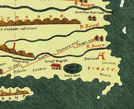
A further possible cultural link appears on the Tabula Peutingeriana, a medieval copy of an ancient Roman road map containing information that may go back to the second century. The map marks Muziris and Tondis and places a large lake behind Muziris. Beside the lake is an icon labelled Templum Augusti, usually understood as a temple of Augustus. This may indicate a Roman temple or a Roman-associated monument, though the evidence does not establish its precise location or character. It is also possible, according to the historical discussion, that a Roman colony existed at Muziris.
Economic Role
Pepper formed the foundation of Muziris's commercial reputation. The Periplus says that pepper was produced in a particular district near the markets and brought to the port. Sangam poetry similarly imagines sacks of pepper piled along the riverbank. The spice moved from the hills through local networks before entering overseas trade.
The known exports included:
- Black pepper and malabathron
- Beryl and other semi-precious stones
- Pearls, diamonds, and sapphires
- Ivory
- Chinese silk
- Gangetic spikenard
- Tortoise shells
Imports carried by Roman or western merchants included gold coins, peridots, fine clothing, figured linens, multicoloured textiles, copper, tin, lead, coral, raw glass, wine, and minerals such as realgar and orpiment. The variety of goods indicates that the trade involved both high-value luxuries and materials used in craft production, adornment, medicine, and ritual.
The trade was organised through multiple kinds of exchange. Tamil poetry sometimes presents the relationship between Chera chiefs and Roman traders as a form of gift exchange rather than a simple commercial transaction. The Muziris papyrus, by contrast, reveals loans, cargo valuation, and financial risk. Both perspectives are valuable: the port's economy involved formal commercial arrangements, but foreign goods also entered systems of royal patronage and elite gift-giving.
The geography of the harbour shaped the labour of trade. Large ships could not easily reach the riverine settlement. Their cargoes were moved into smaller craft, which travelled through the shallows and up the river. Warehouses and landing facilities were therefore essential parts of the port's economic infrastructure.
Archaeology and the Pattanam Debate
The search for Muziris has a long history. Excavations at Kodungallur beginning in 1945 did not produce material datable earlier than the thirteenth century. A 1969 excavation at Cheraman Parambu, about two kilometres north of Kodungallur, recovered artefacts from the thirteenth and sixteenth centuries but did not establish an ancient port of the Roman period.
A large hoard of Roman coins found in 1983 at a site about 9.7 kilometres from Pattanam suggested an inland trade link. The route may have connected the Muziris region through the Palghat Gap and the Kaveri Valley to India's east coast.
Excavations at Pattanam began to transform the debate. Seven seasons were completed between 2007 and 2014 under the Kerala Council for Historical Research. The archaeological evidence demonstrates that Pattanam was a port frequented by Romans and had a long history of habitation extending back to the tenth century BCE. Roman trade connections reached a peak between the first century BCE and the fourth century CE.
Finds connected Pattanam with the Mediterranean, Red Sea, West Asia, South Arabia, Mesopotamia, China, and the Indian subcontinent. Mediterranean material from approximately 100 BCE to 400 CE includes amphora fragments, terra sigillata, Roman glass pillar bowls, and gaming counters. West Asian and related objects include turquoise-glazed pottery, torpedo jars used to transport liquids, and crumbs of frankincense.
The site also produced Indian rouletted ware, black-and-red ware, gemstones, glass beads, semi-precious stone beads, inlays, intaglios, cameo blanks, coins, spices, pottery, and terracotta objects. Chinese blue-and-white porcelain from a much later period, between about 1600 and 1900 CE, reflects the continued or renewed presence of long-distance connections in the wider settlement area.
The evidence for urban life is particularly important. Excavators found burnt bricks, roof tiles, ring-wells, storage jars, toilet features, lamps, coins, styluses, personal ornaments, and scripts written on pottery. Industrial activity is represented by iron, copper, gold, and lead objects, crucibles, slag, furnaces, lapidary remains, and spindle whorls indicating weaving.
The most striking maritime discovery was a fired-brick wharf complex with nine bollards. A badly decayed but mud-preserved canoe lay among the structures. Approximately six metres long, the canoe was made from Artocarpus hirsutus, a tree common on the Malabar Coast and used in boatbuilding. The bollards were made of teak. Together, the wharf, boat, and mooring installations show that Pattanam supported substantial maritime activity.
Some researchers have argued that these findings identify Pattanam as Muziris. Others have objected that the evidence proves an important Roman-connected port but does not by itself prove the ancient name. Historians including R. Nagaswamy, K. N. Panikkar, and M. G. S. Narayanan called for further analysis. Rajan Gurukkal supported the general identification but described the site, in his assessment, as possibly a colony of Mediterranean merchants rather than a fully evolved administrative or urban centre. The debate continues because the literary descriptions, changing coastline, and archaeological record must be fitted together without assuming that every ancient port object belongs to a single named settlement.
DNA analyses of skeleton samples from Pattanam have been interpreted as indicating people with West Eurasian genetic imprints. This has been presented as evidence of the port's international character. The Archaeological Survey of India has been more cautious and has indicated that further research is needed before drawing firm conclusions about Eurasian presence.
Monuments and Architecture
No surviving monumental architecture can be securely identified as ancient Muziris. The ancient port was a working maritime settlement rather than a site known primarily for temples, palaces, or fortifications. Its built environment included practical structures: wharves, warehouses, brick installations, ring-wells, storage areas, furnaces, and boat-handling facilities.
The Pattanam wharf is the clearest architectural evidence connected with port activity. Its fired bricks, bollards, and associated canoe reveal how boats were received and cargoes handled. The combination of landing structures and warehouse evidence supports the picture given by the Periplus: ocean-going ships remained near the coast while smaller vessels carried goods through shallow waters.
The wider Muziris Heritage Project also includes Kottappuram, where a sixteenth-century fort was excavated from May 2010. The fort is much later than the ancient port and should not be treated as a surviving monument of Roman-period Muziris. Its inclusion reflects the long historical importance of the central Kerala landscape and the succession of trading and political sites around the Periyar and its waterways.
Famous Personalities and Historical Voices
Muziris is associated with several writers and observers rather than with a securely identified dynasty of named port governors.
Ilango Adigal, described as a Jain poet-prince from Kodungallur, is traditionally associated with the Cilappatikaram. His account of Greek traders, pepper, gold, and seasonal voyages offers a Tamil literary perspective on the port.
The anonymous author of the Periplus of the Erythraean Sea supplied the most detailed ancient description of Muziris's maritime position, trade, anchorage, and cargo-handling arrangements.
Pliny the Elder recorded the voyage from the Red Sea to Muziris, the use of the southwest monsoon, the port's pirate problem, and the difficulties of loading and unloading ships. Ptolemy placed Muziris in his geographical system and connected it with the Pseudostomus River.
The Sangam poets Erukkattur Tayankannanar and Paranar are associated with poems that mention Muciṟi. Their verses portray the port through images of ships, pepper, gold, markets, river traffic, war, and royal generosity.
Modern scholarship has been shaped by historians and archaeologists including Rajan Gurukkal, Dick Whittaker, R. Nagaswamy, K. N. Panikkar, and M. G. Narayanan. Their differing interpretations show why Muziris remains an active historical question rather than a simple archaeological label.
Decline and Revival
Muziris did not necessarily vanish in a single moment. Roman commerce declined after the fifth century, and the port's position may already have been changing as trade routes, political relationships, and maritime priorities shifted. Persian, Arab, and Chinese contacts continued to draw attention to the region, but the ancient name eventually disappeared from known maps.
The Periyar's changing channels and the accumulation of silt likely affected the port over a long period. The floods of 1341 are associated with a particularly dramatic transformation: the creation or opening of new waterways around Kochi and Vembanad, the formation of Vypin, and the reshaping of the estuary. Such changes could redirect shipping and transfer commercial importance to another harbour.
Modern interest in Muziris began with the attempt to match ancient literary references to the geography of Kerala. The Muziris Heritage Project was developed by the Kerala Tourism Department after the discoveries at Pattanam. Its aim is to restore the historical and cultural significance of the wider Muziris region by connecting archaeological sites, historic buildings, and monuments in central Kerala. It does not resolve the location debate, but it has encouraged public engagement with the port's layered history.
Modern Heritage and Historical Importance
Today, Muziris is best understood as a historical landscape rather than a single confirmed ruin. The ancient settlement has not been securely located, and the modern places associated with it—Kodungallur, Pattanam, North Paravur, and the Periyar estuary—belong to a changing riverine and coastal environment.
Pattanam is the strongest archaeological candidate because its finds correspond closely to the period and activities described in ancient accounts. The site was inhabited long before the Roman trading peak and continued to show evidence of international contacts across later periods. Its wharf, boat, imported ceramics, industrial installations, and writing provide a material picture of a cosmopolitan port.
At the same time, identifying Pattanam with Muziris requires caution. Ancient names could refer to ports, market districts, river mouths, or broader commercial zones. The coastline itself shifted, and the port may have occupied more than one landing place over time. The archaeological record confirms Pattanam's importance but does not end the discussion over its ancient name.
Muziris matters because it places early South India firmly within the history of the Indian Ocean. Pepper grown in the Malabar region reached merchants connected with Egypt and the Mediterranean. Gold, coral, glass, wine, textiles, and other goods travelled in the opposite direction. Loans and cargo valuations reveal complex financial systems, while Tamil poetry records the local social and political meaning of this commerce.
The port also demonstrates that ancient globalisation was not a one-way movement from Rome to India. Local producers, Chera rulers, river boatmen, warehouse workers, artisans, merchants, and overseas financiers all contributed to the system. Muziris was created by the interaction of these regional and international networks.
Timeline
Early Historic Port
Muciṟi appears within the commercial and political world of the Chera country; the period is approximate.
Sangam Descriptions
Tamil poems describe ships, pepper, gold, river traffic, markets, and the prosperity of Muciri.
Graeco-Roman Maritime Trade
The Periplus describes Muziris as a leading market of the Chera kingdom, supplied by ships from Arabia and the Greek world.
Muziris Papyrus
A second-century Greek papyrus records a cargo loan involving pepper and spices shipped from Muziris to Egypt.
Possible Jain Evidence
A Tamil-Brahmi inscription found at Pattanam may refer to a Jain, though the reading remains cautious.
Cilappatikaram Tradition
The Tamil epic describes Greek traders exchanging gold for pepper at Muziris.
Changing Overseas Trade
Roman trade with South India declines, while the region continues to attract Persian, Arab, and Chinese connections.
Muyirikode
An 11th-century Chera copper plate records the name Muyiṟikkōṭŭ, later linked by some scholars with the Muziris tradition.
Periyar Floods
Major flooding and geographical change in the Periyar region are associated with the opening of new waterways and the disappearance of Muziris from maps.
Kodungallur Excavations
Excavations begin at Kodungallur but produce no material securely dated before the thirteenth century.
Pattanam Excavations
Systematic excavations uncover imported ceramics, industrial remains, a wharf, bollards, and a preserved wooden canoe.
Kottappuram Excavation
The sixteenth-century fort at Kottappuram is excavated as part of the Muziris Heritage Project.