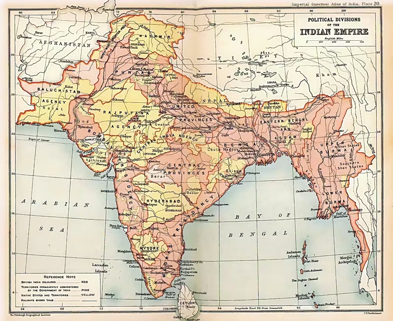
Political Integration of India, 1947–1956
Introduction
In August 1947, the territory that became independent India was not a single administrative unit. It consisted of provinces ruled directly by Britain, 562 princely states governed by hereditary rulers under British paramountcy, and several French and Portuguese enclaves. This map follows the political transformation of that fragmented landscape into an Indian Union whose former princely territories were, by 1956, administered in ways increasingly similar to the old British Indian provinces.
The map is therefore not a record of one empire’s expansion. It is a map of state formation: the end of British paramountcy, the signing of Instruments of Accession, the creation of princely unions, the absorption of colonial enclaves, and the constitutional changes that followed. The process involved negotiation and guarantees, but also popular movements, communal conflict, military action, and unresolved disputes. Junagadh, Jammu and Kashmir, Hyderabad, and the Portuguese territories each followed a different path.
The central figures were Lord Louis Mountbatten, the last British viceroy and the first Governor-General of independent India; Sardar Vallabhbhai Patel, political head of the States Department; and V. P. Menon, its administrative head. Jawaharlal Nehru and Mahatma Gandhi shaped the Congress position that the people of the states, rather than their rulers alone, had the right to determine their political future.
Historical Context
British India and the princely states
Before independence, India was divided into two broad categories. British India comprised provinces under direct colonial rule. The princely states retained hereditary rulers and varying degrees of internal authority, but they were subordinate to the British Crown through the principle of paramountcy.
The relationship between Britain and the princely states was not uniform. Some rulers possessed substantial internal autonomy. Others were subject to close British supervision. In some territories, the ruler exercised powers that were limited enough for the state to resemble a landed estate more than a fully independent polity. External relations were controlled by the British, and subsidiary alliances placed the states within the political and military system of the British Empire in India.
During the early nineteenth century, British policy often favoured annexation. The Indian Rebellion of 1857 altered that approach. The British formally renounced annexation in 1858 and thereafter relied on paramountcy, subsidiary alliances, and treaty relationships. Princely states were protected as allies, but the British Crown remained the ultimate suzerain.
The system became more centralised during the twentieth century. The Chamber of Princes was created in 1921 as a consultative body. In 1936, the supervision of smaller states was shifted from provincial authorities to the centre, while direct relations were established between the Government of India and several larger states. The Government of India Act of 1935 proposed a federation joining British India and the princely states, although the scheme was abandoned after the outbreak of the Second World War in 1939.
Congress and responsible government
The Indian National Congress initially concentrated its organisational resources on British India. The princely states had their own administrations, and Congress leaders were also cautious about intervening in their internal affairs. That position changed gradually.
In 1920, under Gandhi’s leadership, Congress declared swaraj, or self-rule, to be its objective and called on the princes to establish responsible government. The Congress position was reiterated at the 1928 Calcutta session. It expressed sympathy with the people of the states and supported peaceful struggles for representative government.
Nehru brought a sharper political challenge. In 1929, he argued that the people of each state had the right to determine its future and rejected the notion that kings possessed an inherent or divine right to rule. Following Congress victories in the 1937 provincial elections, Congress ministries became more active in supporting political movements inside princely India. Protests, satyagrahas, and campaigns for responsible government developed in several states.
Gandhi participated directly in the Rajkot agitation, demanding full responsible government. He also argued in 1937 for a federation joining British India and the princely states under an Indian central government. By 1939, Congress considered the princely states anachronistic and maintained that they should enter independent India with the same broad constitutional position as the provinces of British India, while their people should receive responsible government.
The end of paramountcy
The transfer of power created a constitutional problem. British paramountcy and the treaties between the Crown and the princely states were not transferred automatically to India or Pakistan. The British government concluded that these relationships would end when Britain departed from India.
In theory, the rulers were then free to negotiate relations with India or Pakistan. Some early British proposals even contemplated the possibility that certain princely states might remain outside both dominions. Congress rejected this possibility because it believed that separate princely sovereignties would fragment the subcontinent.
The problem was not merely constitutional. Railways, customs arrangements, irrigation systems, ports, communications, and commercial networks connected the princely states to British India. Breaking these links would have threatened the economic life of the region. Mountbatten therefore believed that accession to India was essential to a workable transfer of power.
Timeline of Integration
- 1920: Congress declares swaraj its goal and calls for responsible government in the princely states.
- 1921: The Chamber of Princes is established.
- 1929: Nehru states that the people of the states must determine their future.
- 1935: The Government of India Act proposes a federation of British India and the princely states.
- 1937: Congress begins more active intervention in political movements within princely India.
- 1939: The proposed federation is abandoned after the outbreak of the Second World War.
- 1946–1947: Congress leaders insist that the princely states cannot remain militarily or politically independent of India.
- July 1947: Patel invites rulers to join India and stresses common interests rather than domination.
- 15 August 1947: British rule ends; the vast majority of princely states have acceded or are in the process of accession.
- 1947–1948: Junagadh, Jammu and Kashmir, and Hyderabad become the most serious accession crises.
- 1 January 1948: Merger Agreements begin integrating several groups of smaller states into neighbouring provinces.
- January 1948: Saurashtra is formed from 222 states in Kathiawar, with further accessions later.
- 1948–1949: Madhya Bharat, the Patiala and East Punjab States Union, Rajasthan, and Travancore-Cochin are created.
- 1950: The Constitution of India classifies territories as Part A, Part B, and Part C states.
- 1954: French control ends de facto in Pondicherry, Karaikal, Yanam, and Mahe; Dadra and Nagar Haveli are also incorporated into India constitutionally.
- 1961: Goa, Daman, and Diu are taken over by India.
- 1956: The States Reorganisation Act and the Seventh Amendment remove the Part A–Part B distinction and complete the principal administrative phase represented by this map.
Territorial Extent and Boundaries
The mapped political landscape
The map distinguishes between political status rather than presenting a simple colour block of national territory. British Indian provinces and princely states were interwoven across the subcontinent. Some princely territories were large and geographically coherent; others were small enclaves or groups of estates. Their legal relationships with Britain also differed.
The map’s core contrast is between:
- British Indian provinces, directly administered by Britain;
- Princely states, ruled by hereditary princes under British paramountcy;
- European colonial enclaves, controlled by France or Portugal;
- Border and special-status territories, whose accession or constitutional relationship required separate treatment.
At independence, the political boundary of India was consequently not equivalent to a single continuous administrative frontier.
Northern frontier
The Himalayan region included Jammu and Kashmir, a princely state whose accession became disputed in 1947. Nepal and Bhutan were not princely states incorporated into India. Nepal was recognised by Britain as de jure independent. Bhutan was treated during the British period as a protectorate outside the international frontier of India, and a 1949 treaty continued India’s responsibility for advice concerning Bhutan’s external affairs.
Sikkim occupied a distinctive position. Historically a British dependency with a status similar to that of princely states, it was regarded during the colonial period as lying within India’s frontiers. After independence, however, Sikkim did not immediately become part of India. A 1950 treaty made it an Indian protectorate, with India responsible for defence, external affairs, communications, and ultimate responsibility for law and order, while Sikkim retained internal autonomy.
Jammu and Kashmir’s northern and western portions came under Pakistani control during the conflict of 1947 and were subsequently known as Pakistan-administered Kashmir. India did not capture the whole of the former princely state. The map must therefore distinguish accession to India from complete territorial control.
Western and north-western regions
The western political landscape included Gujarat, Kathiawar, Kutch, and the border states of Rajasthan and Punjab. Jodhpur and Jaisalmer negotiated with Muhammad Ali Jinnah, who sought to attract major border states to Pakistan. Jinnah offered Jodhpur and Jaisalmer broad freedom to set their own terms of accession.
Jaisalmer declined, in part because its ruler feared the consequences of siding with a Muslim-majority dominion against Hindu populations during communal conflict. The ruler of Jodhpur came close to joining Pakistan but ultimately acceded to India. Mountbatten argued that the accession of a predominantly Hindu state to Pakistan would conflict with the principle of the two-nation theory and could provoke communal violence.
Kutch was treated as a sensitive border territory. Rather than being merged into another state, it became a Chief Commissioner’s Province under central government control.
Western and southern regions
Junagadh lay in south-western Gujarat and had no common land border with Pakistan. Its Muslim ruler acceded to Pakistan, arguing that the state could be reached by sea. India rejected this accession, citing geography and the state’s predominantly Hindu population.
The rulers of Mangrol and Babariawad, which were subordinate to Junagadh, declared their independence from Junagadh and acceded to India. Junagadh’s forces occupied them, while a provisional government, the Aarzi Hukumat, was formed by Junagadhi political activists. India reoccupied Mangrol and Babariawad, cut fuel and coal supplies, and severed air and postal connections. After the Nawab fled to Pakistan, Junagadh’s court invited India to administer the state. A plebiscite held in February 1948 voted almost unanimously for accession to India. Pakistan continued to claim sovereignty over Junagadh.
Hyderabad was the largest major crisis in the south. The landlocked state extended across more than 82,000 square miles, or over 212,000 square kilometres, in south-eastern India. Its population was approximately 17 million, about 87 percent of whom were Hindu, while the ruler, Nizam Osman Ali Khan, was Muslim and the political elite was dominated by Muslims.
Hyderabad’s strategic position was central to the Indian government’s argument for integration. The state lay across major communication lines connecting northern and southern India. Indian leaders argued that an independent Hyderabad could become vulnerable to foreign influence and threaten India’s security.
Eastern and north-eastern regions
The map includes the eastern and north-eastern states that followed paths different from the larger western and central unions. Manipur acceded to India on 11 August 1947 and Tripura on 13 August. Both were later treated as sensitive border territories and retained as Chief Commissioners’ Provinces rather than being immediately merged into neighbouring units.
The former Punjab Hill States Agency comprised thirty states near the international border. Although these states signed Merger Agreements, they were integrated into Himachal Pradesh, which was administered directly by the centre as a Chief Commissioner’s Province for security reasons.
Administrative Structure
Instruments of Accession
The Instrument of Accession was the principal legal mechanism used to secure the initial entry of princely states into India. For states that retained internal autonomy under British rule, the document generally transferred three subjects to the Government of India:
- defence;
- external affairs;
- communications.
These subjects were defined with reference to the relevant schedule of the Government of India Act of 1935.
The Instrument of Accession also contained safeguards. One clause stated that the ruler would not be bound by the future Indian Constitution unless he accepted it. Another guaranteed autonomy in matters not transferred to India. Additional assurances concerned personal privileges, extra-territorial rights, exemption from customs duties, titles, honours, and the continued position of the rulers.
The agreements produced a deliberately limited form of accession. They did not immediately create a fully centralised state. They were intended to make accession acceptable to rulers who feared the loss of their authority.
Rulers of territories that functioned more like estates or talukas signed different forms, transferring residual powers and jurisdiction to India. A third category preserved the degree of authority held by rulers under British rule. The political map therefore contained not only different territories but different constitutional relationships.
Standstill Agreements
Standstill Agreements were designed to preserve existing administrative arrangements while longer-term political questions were settled. They were especially significant in Hyderabad and Jammu and Kashmir.
The States Department used the Standstill Agreement as a negotiating instrument. It refused to conclude such an agreement with states that would not also sign an Instrument of Accession. In practice, these agreements helped maintain communications, services, and administrative continuity during the transfer of power.
Merger Agreements
Accession alone would have left India with a loose federation and wide differences in administration. Between 1947 and 1950, the Government of India therefore pursued a second stage: the merger of small states into neighbouring provinces or larger princely unions.
The Merger Agreements required rulers to surrender full and exclusive jurisdiction over the governance of their territories to the Dominion of India. In exchange, rulers received privy purses, protection for private property, recognition of personal privileges and titles, and guarantees concerning succession and the treatment of state employees.
The process was controversial because the Indian government had recently assured rulers that their states would continue to exist. Patel and Menon argued that many small states lacked the resources to maintain functioning administrations, support their populations, or remove barriers to trade. They also warned that administrative fragmentation could produce economic collapse and disorder.
Princely unions
Larger states and groups of smaller states were combined through Covenants of Merger. Under these arrangements, most rulers lost their governing powers. One ruler became the Rajpramukh, or constitutional head, while other rulers participated in councils or presidiums.
Important unions included:
- Saurashtra: formed in January 1948 from 222 states in the Kathiawar peninsula, with six additional states joining the following year;
- Madhya Bharat: formed on 28 May 1948 from Gwalior, Indore, and eighteen smaller states;
- Patiala and East Punjab States Union: formed on 15 July 1948 from Patiala, Kapurthala, Jind, Nabha, Faridkot, Malerkotla, Nalagarh, and Kalsia;
- Rajasthan: created through a series of mergers completed on 15 May 1949;
- Travancore-Cochin: formed in the middle of 1949.
Kashmir, Mysore, and Hyderabad signed neither Covenants of Merger nor Merger Agreements during this phase. Their constitutional position therefore remained distinctive for longer.
Democratisation
Merger did not automatically create democratic government. Some former princely states had legislative institutions based on relatively broad franchise. Others were governed by small aristocratic circles, court factions, or paternalistic administrations.
In December 1947, Menon proposed requiring the rulers of the new unions to take practical steps towards popular government. The States Department implemented this through a special covenant. Rajpramukhs agreed to act as constitutional monarchs, making their powers broadly comparable to those of governors in former British provinces.
This arrangement extended central authority while presenting the process as constitutional development. It also gave residents of the merged territories a form of responsible government closer to that available in the former provinces.
Constitutional centralisation
The original Instruments of Accession transferred only limited subjects. Congress leaders believed this arrangement would obstruct national policies concerning social justice, economic development, and administration. In May 1948, Rajpramukhs agreed to new Instruments of Accession allowing the Government of India to legislate on all matters covered by the relevant schedule of the Government of India Act of 1935.
The princely unions, along with Mysore and Hyderabad, later agreed to adopt the Constitution of India as the constitution of their states. By 1950, the Constitution classified India’s constituent units into:
- Part A states: former British provinces and princely states merged into them;
- Part B states: princely unions, Mysore, and Hyderabad;
- Part C states: former Chief Commissioners’ Provinces and other centrally administered areas.
The distinction between Part A and Part B was largely administrative and transitional. The Rajpramukhs of Part B states served as constitutional heads, while governors appointed by the centre headed Part A states.
The States Reorganisation Act of 1956 and the Seventh Amendment removed the distinction between Part A and Part B states. Rajpramukh authority ended, and the territories of former princely states became fully integrated into the Indian constitutional system.
Infrastructure and Communications
The political geography of integration was shaped by infrastructure as much as by legal status. Railways, customs arrangements, irrigation systems, ports, and communications connected the princely states with British India. Mountbatten argued that severing these networks would threaten trade, commerce, and the economic life of the subcontinent.
Communications were also strategically important during the accession crises. In Junagadh, India cut air and postal links after rejecting the accession to Pakistan. In Jammu and Kashmir, transport links with India were tenuous and affected by seasonal flooding, while the state’s connections with Pakistan became increasingly important during the crisis of 1947.
Hyderabad’s location astride communication lines between northern and southern India was central to the Government of India’s security case. The concern was that an independent state in this position could obstruct or threaten the movement of people, goods, and military forces across the Union.
The Instruments of Accession explicitly identified communications as one of the three subjects commonly transferred to India. This reflected the practical reality that railways, posts, telegraphs, and related systems could not easily be divided along the boundaries of hundreds of states.
The Standstill Agreements were intended to preserve existing services while the political future of each state was settled. Their purpose was administrative continuity rather than the creation of new infrastructure.
Economic Geography
Interdependence and customs
The princely states were economically linked to British India through arrangements concerning railways, customs, ports, irrigation, and trade. State boundaries could interfere with the movement of goods and the collection of revenue. Patel and Menon argued that many small states lacked the resources to maintain independent economic systems and that restrictions on trade had to be dismantled.
The Government of India therefore treated political integration as an economic necessity. The objective was not only to unite territories under a common constitution but also to remove administrative barriers that divided markets and transport systems.
Hyderabad’s resources and strategic position
Hyderabad’s bid for independence rested partly on the political power of the Nizam and the Muslim elite that dominated the state. The Government of India countered that its location and connections made separation impractical. Hyderabad was landlocked and lay across the main lines of communication between northern and southern India.
The Nizam also sought safeguards beyond those offered in the standard Instrument of Accession, including neutrality in any conflict between India and Pakistan. India rejected this proposal because it feared that special arrangements for Hyderabad would encourage other states to demand similar concessions.
Travancore and thorium
Travancore’s resistance to accession was linked in part to the strategic importance of its thorium reserves. The state sought recognition from Western countries and pointed to the international significance of these resources. Its plans for independence were abandoned after the attempted assassination of its dewan, Sir C. P. Ramaswami Iyer.
The episode illustrates that economic geography and natural resources were part of the political negotiations, even where they did not determine the final outcome.
Ports and colonial enclaves
The remaining French and Portuguese enclaves created another layer of economic and political fragmentation. France controlled Pondicherry, Karaikal, Yanam, Mahe, and Chandernagore. Portugal controlled Daman and Diu, Dadra and Nagar Haveli, and Goa.
Junagadh’s ruler argued that the state could connect with Pakistan by sea despite lacking a common land border. This claim highlighted the importance of maritime access in debates over accession. Hyderabad also considered acquiring or leasing Goa from Portugal to secure access to the sea.
The French enclaves were transferred to Indian control in stages after elections, negotiations, and pro-merger movements. Portuguese rule ended only after military action in 1961.
Cultural and Religious Geography
Communities and political choices
Religious demography influenced the accession crises, but it did not produce a uniform pattern. Junagadh had a Muslim ruler and a predominantly Hindu population, and its accession to Pakistan was rejected by India. Hyderabad had a Muslim ruler and Muslim political elite but a population that was approximately 87 percent Hindu. Jammu and Kashmir had a Hindu ruler and a Muslim-majority population.
These cases became central to competing claims about sovereignty, popular will, geography, and the two-nation theory. India argued that the location and population of Junagadh made accession to Pakistan unacceptable. Pakistan criticised India’s refusal to recognise Junagadh while supporting Kashmir’s accession to India.
The rulers’ religious identities did not alone determine their decisions. Political ideology, economic interests, military vulnerability, popular movements, and the actions of Congress and the Muslim League all shaped the outcome.
Popular movements
Popular pressure was an important force behind integration. Many residents of princely states favoured joining India, while movements demanded representative government. This reduced the ability of rulers to maintain independent positions.
In Hyderabad, the Telangana Rebellion began in 1946 as a peasant revolt against feudal elements. The Razakars, a militia associated with the Ittehad-ul-Muslimeen, supported the Muslim ruling class and were accused of intimidating villages. The Hyderabad State Congress organised political agitation, while communist groups later attacked Congress groups as the situation deteriorated.
In Jammu and Kashmir, Sheikh Abdullah and the National Conference opposed Maharaja Hari Singh’s rule and demanded his abdication. The political conflict within the state shaped the terms under which India provided military assistance.
Sikkim’s later integration also reflected social and ethnic divisions. The Chogyal was supported by minority Bhutia and Lepcha upper classes, while Kazi Lhendup Dorji and the Sikkim State Congress represented Nepali middle classes and favoured a closer relationship with India.
Languages and reorganisation
Language became increasingly important after the first phase of political integration. The States Reorganisation Act of 1956 reorganised the former provinces and princely territories on a linguistic basis. This replaced the temporary Part A, Part B, and Part C classification with a more uniform system of states and union territories.
The later Telangana movement demonstrates that linguistic unity did not remove all regional distinctions. Telangana, comprising Telugu-speaking districts of the former Hyderabad State, differed in significant ways from the Telugu-speaking areas of British India with which it had been merged. The region eventually became a separate state in 2014.
Military Geography
The role of military power
The integration of most princely states was achieved through negotiation, but military power shaped the bargaining environment. Nehru stated in 1946 and 1947 that no princely state could prevail militarily against the army of independent India. This message made formal independence difficult to sustain, particularly for states without external support, secure borders, or viable communications.
Mountbatten, Patel, and Menon combined assurances with pressure. Rulers were offered guarantees and privy purses, but the Government of India also made clear that it would not accept a fragmented subcontinent threatening national security.
Junagadh
Junagadh’s accession to Pakistan produced a military and political crisis in Gujarat. The rulers of Mangrol and Babariawad acceded to India, Junagadh occupied them, and neighbouring states moved troops towards the frontier. India reoccupied the two subordinate principalities and imposed economic and communications pressure on Junagadh.
After the Nawab fled, the state administration collapsed. India took over at the invitation of Junagadh’s court, and the February 1948 plebiscite confirmed accession to India by an almost unanimous vote.
Jammu and Kashmir
The Jammu and Kashmir crisis developed rapidly after the Maharaja initially sought independence. Hari Singh signed a Standstill Agreement with Pakistan and proposed one with India. Pakistan then cut supplies and transport links. Pathan tribesmen from Pakistan’s North-West Frontier Province crossed into Kashmir and advanced towards Srinagar.
The Maharaja requested Indian military assistance. India required an Instrument of Accession and the establishment of an interim government headed by Sheikh Abdullah. Hari Singh complied. Indian forces secured Jammu, Srinagar, and the Kashmir Valley, but fighting continued until a ceasefire.
The United Nations adopted a three-part resolution on 13 August 1948, and India accepted a ceasefire on 1 January 1949. The proposed plebiscite was never held. The Constitution of India came into force in Jammu and Kashmir in 1950 with special provisions, while northern and western portions remained under Pakistan’s control.
Hyderabad and Operation Polo
Hyderabad’s internal conflict became increasingly violent. The Telangana Rebellion challenged feudal power, the Hyderabad State Congress demanded political change, and the Razakars intensified their activities. Negotiations led by Mountbatten failed to produce a settlement.
On 7 September 1948, Nehru demanded that the Nizam ban the Razakars and return Indian troops to Secunderabad. On 13 September, two days after Jinnah’s death, the Indian Army entered Hyderabad under Operation Polo. The operation was justified on the grounds that the law-and-order situation threatened peace in southern India.
Indian troops met limited resistance from the Razakars and took complete control of the state between 13 and 18 September. The operation was followed by extensive communal violence. Estimates of deaths vary considerably, from official figures of 27,000–40,000 to scholarly estimates of 200,000 or more. The Nizam remained head of state after accession, but Hyderabad was absorbed into India.
Political Geography
India, Pakistan, and the princes
The division between India and Pakistan framed every major accession question. The Muslim League, represented by Jinnah, supported the right of princely states to remain independent. This position conflicted with Congress, which argued that the states were not sovereign entities capable of standing apart from independent India.
Pakistan supported Hyderabad’s attempt to remain independent and accepted Junagadh’s accession. India rejected both positions. The two governments also disagreed over the legal and political comparison between Junagadh and Jammu and Kashmir.
The inability of the princes to form a united front weakened their negotiating position. Smaller states distrusted larger rulers, while many Hindu rulers viewed the Nawab of Bhopal, Hamidullah Khan, as too close to Pakistan. The Muslim League’s decision not to join the Constituent Assembly damaged the princes’ plan to cooperate with it against Congress pressure.
Mountbatten’s diplomacy
Mountbatten used his personal relationships with rulers to encourage accession. He told the princes that Britain would not grant separate dominion status to individual states or accept them into the Commonwealth. The British Crown would sever its links with the states unless they joined India or Pakistan.
He also emphasised the economic unity of the subcontinent and the difficulties rulers would face in maintaining order amid communal violence and communist movements. In discussions over Bhopal, Mountbatten presented the Instrument of Accession as a means of securing the practical independence that rulers needed while avoiding political isolation.
Some princes believed Britain had abandoned them. Sir Conrad Corfield resigned as head of the Political Department in protest against Mountbatten’s policies. Historians have disagreed about Mountbatten’s role. Some argue that the princes had little realistic choice once Britain withdrew; others emphasise the extent to which the terms of accession were later altered.
Patel and Menon
Patel’s public approach was conciliatory. On 5 July 1947, he emphasised India’s unity and common interests with the states. He assured rulers that the States Department would not be an instrument of domination and invited them to join India so that they could make laws together as friends rather than negotiate as aliens.
Menon transformed this political strategy into administrative agreements. The Instrument of Accession, Standstill Agreement, Merger Agreement, and later constitutional arrangements created a sequence through which accession could be obtained without immediately demanding complete surrender of authority.
The distinction between Patel’s and Nehru’s methods was important. Nehru articulated the Congress commitment to popular sovereignty and rejected the independence of princely states. Patel and Menon negotiated with rulers by offering safeguards, privileges, and staged integration.
Colonial enclaves
The incorporation of the French and Portuguese enclaves extended the process beyond the princely states.
Chandernagore held a plebiscite on 19 June 1949. The vote was 7,463 to 114 in favour of integration with India. Control was transferred de facto on 14 August 1949 and de jure on 2 May 1950.
In Pondicherry, Karaikal, Yanam, and Mahe, pro-merger movements gained strength after demonstrations in 1954. A referendum in Pondicherry and Karaikal in October 1954 favoured merger, and de facto control over all four enclaves passed to India on 1 November 1954. A treaty of cession was signed in May 1956, while de jure transfer followed ratification by the French National Assembly in May 1962.
Portugal resisted negotiated transfer. An uprising ended Portuguese control in Dadra and Nagar Haveli in 1954. The International Court of Justice rejected Portugal’s complaint in 1960 and held that India could deny Portuguese military access to the enclaves. The Indian Constitution was amended in 1961 to incorporate Dadra and Nagar Haveli as a Union Territory.
Goa, Daman, and Diu remained under Portuguese rule until December 1961. On 18 December, the Indian Army entered Portuguese India and defeated the garrisons. Portugal surrendered on 19 December. Goa became a centrally administered Union Territory and later a state in 1987.
Legacy and Decline of the Princely Order
From accession to integration
The princely order did not end in a single moment. Independence ended British paramountcy, but accession initially transferred only selected powers. Merger Agreements then dissolved many states as separate political entities. Princely unions introduced new administrative structures, while constitutional changes reduced the rulers to ceremonial or private positions.
By 1950, the former princely territories had entered the constitutional framework of the Republic of India, although Part B states retained a distinctive status. The 1956 reorganisation removed that distinction. The territories of former princely states no longer differed in law or administration from those of former British India.
The rulers received privy purses and retained titles, dignities, privileges, and protection for private property for a time. These arrangements were abolished in 1971.
The limits of a completed map
The map’s endpoint in 1956 should not be mistaken for the end of every territorial or constitutional question. Jammu and Kashmir retained a special relationship with India and remained divided between Indian- and Pakistani-controlled areas. Kashmir’s distinctive constitutional history later became associated with political dissatisfaction and an insurgency that began in 1989.
Tripura and Manipur also experienced separatist movements as part of the wider political problems of north-eastern India. These movements are generally studied in the broader context of tribal aspirations, migration, demographic change, and the failure of governments to address regional demands rather than solely as consequences of princely-state integration.
Sikkim followed an even later path. In 1975, after political agitation, negotiations, elections, and a referendum, the Sikkim Assembly requested full integration into India. The referendum endorsed the proposal, and the Indian Parliament admitted Sikkim as India’s twenty-second state.
Regional consequences
The integration of princely India created the territorial foundation for a centralised republic. It removed hundreds of internal political boundaries, established common constitutional authority, and connected formerly separate administrations to national systems of legislation, transport, revenue, and communications.
At the same time, the process left a complex legacy. It combined popular movements with elite negotiation, constitutional guarantees with centralisation, and peaceful merger with military intervention. The later demand for Telangana showed that the merger of territories did not erase regional identities or unequal political histories.
The historical importance of the map lies in this transition. It shows how an uneven imperial geography became a constitutional union, not through one uniform treaty or one military campaign, but through a series of different settlements shaped by geography, demography, economic interdependence, diplomacy, and force.