Overview
On the eastern side of the ancient settlement, a long trapezoidal basin of burnt brick preserves the central mystery of Lothal. It has an inlet, a sluice-like opening, channels, and a raised wharf connected to a warehouse and the town's administrative quarter. For decades, the structure has been identified as one of the earliest known dockyards. Other archaeologists have argued that it was primarily an irrigation tank or a basin for river craft. The debate has made Lothal especially important: it is not only an archaeological site, but also a place where changing evidence continues to shape our understanding of the Harappan world.
Lothal was a planned settlement of the Indus Valley, or Harappan, Civilisation in what is now Gujarat. Construction of the city is generally placed around 2300 BCE. The settlement occupied a strategic landscape near the Gulf of Khambhat, connected to river channels and coastal routes. Its inhabitants produced beads, shell objects, metal tools, ornaments, pottery, seals, ivory goods, and other products. These moved through networks extending toward the Persian Gulf, Sumer, West Asia, Bahrain, and possibly Egypt and Africa.
The site also reveals how an urban community managed water, waste, production, administration, and repeated environmental disaster. Streets were laid out in regular lines. Houses and workshops stood on raised platforms. The town had an acropolis, a lower settlement, a marketplace, drainage systems, wells, bathing platforms, a warehouse, and specialized craft areas. The population rebuilt parts of the city after floods and storms, but later changes in the river, increasing salinity, weakened rainfall, and declining public administration eventually reduced Lothal's urban and commercial importance.
Today, Lothal lies near Saragwala in Dholka Taluka of Ahmedabad district, Gujarat. The Archaeological Survey of India excavated the settlement between 1955 and 1960, with further work continuing after a later phase resumed in 1961. Excavated remains and artefacts are displayed at the Archaeological Museum beside the site.
Etymology and Names
The name Lothal is explained in Gujarati as a combination of Loth and thal, meaning “the mound of the dead.” The meaning is comparable to that of Mohenjo-daro, whose name in Sindhi carries the same sense. The name is associated with the visible mound and the ancient remains known to people living in neighbouring villages.
Lothal was not necessarily the ancient name used by its inhabitants. The settlement's Harappan script remains undeciphered, and no confirmed ancient name for the city has been established. For this reason, “Lothal” is best understood as the later regional name by which the archaeological mound became known.
The site was sufficiently prominent in the local landscape that its remains were remembered before modern excavation. Villagers knew of the ancient settlement and human remains. Local environmental changes also preserve hints of its earlier relationship with water. In the nineteenth century, boats could reportedly travel as far as the mound. In 1942, timber was transported from Broach to Saragwala through the area. A silted creek linking modern Bholad with Lothal and Saragwala has been interpreted as a remnant of an older river or creek channel.
Geography and Location
Lothal stands in the Bhat region of Gujarat, near the Gulf of Khambhat. It is situated close to Saragwala in Dholka Taluka, in present-day Ahmedabad district. The site lies approximately six kilometres southeast of Lothal–Bhurkhi railway station on the Ahmedabad–Bhavnagar railway line. It is connected by all-weather roads with Ahmedabad, Bhavnagar, Rajkot, and Dholka. Ahmedabad is approximately 85 kilometres away.
The physical setting was central to Lothal's history. The settlement was built on or beside a former salt marsh that was affected by tides. River channels connected the site with the wider coastal landscape. The ancient settlement therefore occupied a boundary zone between inland agriculture, river transport, and maritime exchange. This location helped Lothal connect the Harappan settlements of Sindh with the Kathiawar Peninsula.
The exact course of the ancient river system has been debated and reconstructed through several kinds of evidence. A silted channel near modern Bholad has been connected with the old flow of water. Remote sensing and topographical studies published in 2004 identified an ancient meandering river adjacent to Lothal. The channel was estimated to have extended for roughly 30 kilometres and may have been an old northern channel of a tributary of the Bhogavo river.
The width of the channels is also significant. Smaller channels near the settlement, measuring between roughly 10 and 300 metres, contrast with the much wider lower reaches of the river system, which could measure between 1.2 and 1.6 kilometres. This difference has been interpreted as evidence of strong tidal influence. Tidal water may have travelled up to and beyond the settlement, while upstream areas provided access to fresh water.
Lothal's position was advantageous but dangerous. Its waterways allowed access to coastal trade, yet tides, tropical storms, monsoon floods, river changes, and soil salinity repeatedly threatened the settlement. The same geography that helped make Lothal a commercial centre also contributed to its decline.
Ancient History
Before the Harappans
Before the expansion of the Harappan settlement, Lothal was a small village near a river. Its location gave local inhabitants access to the mainland from the Gulf of Khambhat. The village already had a productive economy. Excavations have revealed copper objects, beads, semi-precious stones, and pottery.
The local ceramic tradition included fine clay vessels with smooth, micaceous red surfaces. The inhabitants improved the firing of pottery under partly oxidizing and reducing conditions, producing black-and-red ware. This tradition is described as indigenous and pre-Harappan. It is important because Lothal was not simply an empty site occupied by outsiders. A local community was already adapting to the riverine and coastal environment before the settlement became a planned Harappan town.
Harappan groups were drawn to Lothal for several reasons. The site offered a sheltered harbour or water basin, access to cotton- and rice-growing land, and an established bead-making tradition. Beads and gemstones produced at Lothal were in demand in western regions. The relationship between the local Red Ware communities and the incoming Harappans appears to have been relatively peaceful. Local inhabitants adopted aspects of Harappan life, while the settlers adopted local techniques and ceramic forms.
The development of a planned town
A flood around 2350 BCE destroyed earlier village foundations and settlements. Harappan inhabitants from the Lothal area and from Sindh then expanded the settlement. They created a planned township influenced by the larger cities of the Indus Valley.
The town was raised on platforms, usually between one and two metres high. These platforms were made from sun-dried bricks and supported groups of approximately 20 to 30 houses. The town was divided into an elevated acropolis and a lower town. The acropolis contained residences, bathing platforms, drains, a well, a warehouse, and buildings associated with authority. The lower town included the marketplace, houses, craft workshops, and additional streets.
The settlement was repeatedly enlarged during periods of prosperity. The organization of the town suggests that its inhabitants understood the need to control both water and movement. Streets followed regular lines, houses were built in planned blocks, and drains were incorporated into the urban layout. The use of raised platforms protected important structures from flooding, at least for a time.
Town Planning and Urban Administration
Lothal's urban design reflects a high degree of planning. The city extended approximately 285 metres from north to south and 228 metres from east to west. At the height of its occupation, habitation extended beyond the central mound, with remains found roughly 300 metres south of it.
The settlement was divided into an acropolis and a lower town. The acropolis formed the political and commercial centre. It measured approximately 127.4 metres east to west and 60.9 metres north to south. Three streets and two lanes ran east to west, while two streets ran north to south. Mud-brick structures formed the sides of the elevated platform. These structures were between roughly 12.2 and 24.4 metres thick and between 2.1 and 3.6 metres high.
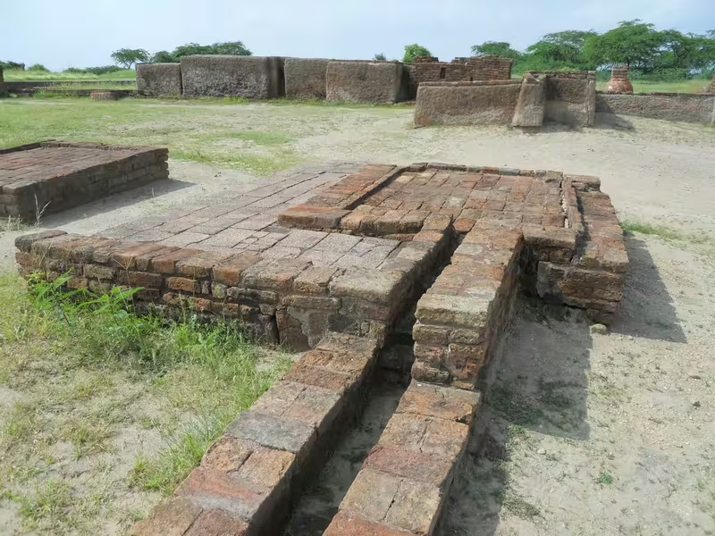
The acropolis contained houses with open courtyards and bathing platforms. Some buildings were mostly two-roomed houses. The paving of the bathing platforms was polished to reduce seepage, and the pavements were lime-plastered. Wooden panels or thin wall coverings were used along some edges.
One identified residence measured approximately 43.92 square metres. It included a bathing platform of about 1.8 square metres and a squat latrine. The latrine was connected to an outside drain that discharged toward the dock or basin. This arrangement shows that water management was part of domestic architecture as well as public infrastructure.
The lower town was organized around a north–south arterial street. The street was approximately six to eight metres wide and served as the main commercial zone. Shops, workshops, and residences stood in straight rows on either side. Some of the earliest housing and brick drains have disappeared, but the street retained a consistent width through several rebuilding phases. Structures were not allowed to encroach on the roadway.
Householders possessed collection chambers, or sumps, for solid waste. Drains, manholes, cesspools, and silting chambers helped control wastewater and refuse. At high tide, waste deposited in the river could be washed away. This arrangement does not represent modern sanitation, but it does reveal deliberate municipal management and an awareness of blockage, flooding, and urban cleanliness.
Lothal's construction standards were also remarkably consistent. Buildings used fired or fire-dried bricks, lime, and sand mortar. The surviving bricks remain bonded after approximately four millennia. Brick-makers used bricks as headers and stretchers in alternating layers. Their dimensions followed a planned ratio, with proportions of approximately 1:0.5:0.25 on three sides. These dimensions were related to larger units on the Lothal measurement scale.
The Basin and the Dockyard Debate
The most famous structure at Lothal is the large trapezoidal brick basin east of the settlement. Its position away from the main river channel may have helped reduce the accumulation of silt. The structure measures approximately 215 metres from north to south and about 35 metres from east to west.
The basin has several features consistent with controlled water movement. An inlet approximately seven metres wide and 0.9 metres deep survives at the northern end. A square opening, approximately one metre on each side, lies in the southern face and has been interpreted as a sluice gate or spillway. The opening may have been controlled with a wooden gate. Another description identifies a main inlet about 12.8 metres wide and an additional opening on the opposite side. Offsets on the outer wall faces may have helped resist the pressure of moving water.
The Archaeological Survey of India identified the basin as a dockyard. In this interpretation, the structure connected Lothal with an ancient course of the Sabarmati river and formed part of a trade route between Harappan settlements in Sindh and the Kathiawar Peninsula. A mud-brick wharf, about 220 metres long, was built along the western arm. A ramp connected the wharf with the warehouse and acropolis. At high tide, between roughly 2.1 and 2.4 metres of water may have entered the basin, allowing vessels to move through the water system. An outlet channel was designed to allow excess water to escape.
The basin may also have been connected to a new river channel after the river changed course around 2000 BCE. A canal approximately seven metres wide and two kilometres long was dug toward the new channel. This would have helped maintain the settlement's access to water after the original route became less effective.
The dock interpretation has been challenged. Lawrence Leshnik, writing in 1968, and Paul Yule, writing in 1982, argued that the feature may have been primarily an irrigation tank. Their objections included the dimensions of the inlet, which they considered too small for ocean-going vessels. In their view, smaller inland boats may have carried goods between the basin and larger ships anchored elsewhere. The limited number of wells in the town was also considered evidence that the basin may have helped irrigate nearby fields, provide bathing water, and receive river boats rather than function as a conventional seaport.
The National Institute of Oceanography in Goa later reported the discovery of foraminifera, or marine microfossils, along with salt and gypsum crystals in the rectangular structure. These findings indicate that seawater once filled the basin and have been used to support its identification as a dockyard. Leshnik's interpretation allows another possibility: marine material could have entered through flood events. The debate therefore remains connected to the interpretation of several details, including five stone weights found around the basin, the source of estuarine shells, five terracotta boat models, and a circular Persian Gulf seal from Bahrain.
The basin's original purpose may also have changed over time. It could have supported different activities during different phases: docking, loading and unloading, irrigation, bathing, or the movement of smaller river craft. The surviving evidence clearly demonstrates controlled water management and contact with marine environments. Whether it should be called a dockyard in the full sense of the term remains a matter of archaeological interpretation.
The Warehouse and Commercial Infrastructure
The warehouse stood beside the basin and close to the acropolis. Its position would have allowed authorities to supervise goods entering and leaving the settlement. The building was placed on a mud-brick platform originally about 4.26 metres high. The surviving platform is lower, measuring approximately 3.35 metres, because of erosion and damage.
The warehouse was built over rows of cubical blocks. Each block measured around 3.6 metres square, with passages approximately 1.2 metres wide between them. The blocks stood on a mud-brick podium about 3.5 metres high. Brick-paved passages between the blocks provided ventilation, while a ramp led directly toward the dock and facilitated loading.
The raised design protected stored goods from floodwater. Yet the system ultimately failed. Major floods destroyed all but twelve of the blocks. Those remaining structures became a makeshift storehouse. The damage shows that even carefully planned infrastructure could not withstand repeated environmental pressure without continued repair.
An important public building stood opposite the warehouse, although its superstructure has disappeared. The arrangement of the basin, warehouse, wharf, ramp, and acropolis indicates that trade was not an unregulated activity. Goods could be monitored, stored, measured, and moved through a defined sequence of spaces.
Economy and Trade
Lothal's economy rested on craft production, agriculture, riverine movement, and long-distance trade. The city imported raw materials such as copper, chert, and semi-precious stones from other regions and distributed finished goods to inland villages and towns.
The settlement's trade networks reached beyond the Indian subcontinent. Evidence suggests connections with the Persian Gulf, Bahrain, Sumer, West Asia, Egypt, and Africa. A coastal route may have linked Lothal and Dholavira with Sutkagan Dor on the Makran coast. The discovery of a circular Persian Gulf seal, associated with Bahrain, is especially important for understanding Lothal's maritime connections.
Lothal exported beads, gemstones, ivory, shells, and ornaments. It also produced bronze celts, fishhooks, chisels, spearheads, bangles, rings, drills, and other objects. Some products served local needs, while others were intended for exchange.
The city used standardized weights, measures, seals, pottery, and metal tools similar to those found elsewhere in the Indus Civilization. Standardization made it possible to conduct transactions across distant settlements. The discovery of sealings suggests that goods were sealed with impressions on mats, twisted cloth, cords, or other packing materials. Seals could identify owners, administrators, or the contents of a consignment.
Lothal's marketplace occupied the main street of the lower town. Shops and workshops were arranged in regular rows. The settlement's organization implies that commerce was closely connected with municipal and administrative systems. In the later period, however, the economy changed. Trade volumes fell, raw materials became scarce, and independent businesses gave way to merchant-centred factories in which many craftsmen worked for a common supplier or financier.
The Bead Industry
Bead-making was among Lothal's most important industries. The city produced beads from agate, carnelian, jasper, steatite, faience, and other materials. Its craftsmen made etched carnelian beads, barrel beads, double-eye beads, collared beads, gold-capped beads, and extremely small cylindrical beads.
The bead factory contained a central courtyard, eleven rooms, a store, and a guardhouse. A cinder dump and a double-chambered circular kiln were also identified. Fuel entered through stoke-holes, and four flues connected the kiln's chambers and fuel area. The floors and walls were vitrified by intense heat.
The remains of reed, cow dung, sawdust, agate, and other materials help reconstruct the production process. Lothal bead-makers selected stones with different colours and patterns, shaped them carefully, and drilled them with great precision. Their techniques were sufficiently advanced that modern bead-makers in the Khambhat region continue to use methods considered comparable.
Lothal's beads travelled widely. Etched carnelian and other beads associated with the Indus tradition have been found at Kish and Ur in modern Iraq, Jalalabad in Afghanistan, and Susa in Iran. Their distribution demonstrates that Lothal's craft production was integrated into a broad exchange system.
Gold-working was equally skilled. Some gold microbeads were less than 0.25 millimetres in diameter. Cylindrical, globular, and jasper gold beads with sharply angled edges resemble ornaments used in Gujarat for decorating braided hair. Gold jewellery, thin copper rings, pendants, and other ornaments indicate both technical ability and access to valuable materials.
Metallurgy, Shell-Working, and Ivory
Lothal's copper was unusually pure and lacked the arsenic commonly used by coppersmiths elsewhere in the Indus Valley. Copper ingots were probably imported from sources beyond the immediate region, possibly from the Arabian Peninsula. Craftsmen mixed tin with copper to make bronze objects.
The metalworkers produced celts, arrowheads, fishhooks, chisels, bangles, rings, drills, spearheads, and ornaments. Weapon production existed but appears to have been less important than tools and decorative objects. Lothal's craftsmen used the cire perdue, or lost-wax, casting technique. They also used multi-piece moulds to cast birds and animals.
Some tools found at Lothal, including curved saws and twisted drills, are described as innovations not known from other contemporary civilizations. These objects demonstrate experimentation in shaping, drilling, casting, and finishing.
Shell-working flourished because high-quality chank shell was available from the Gulf of Kutch and the Kathiawar coast. Workshops produced gamesmen, beads, unguent vessels, ladles, inlays, and other objects for both local use and export. Components of stringed instruments, including plectrums and bridges, were also made from shell.
An ivory workshop operated under close official supervision. Excavated material includes an ivory seal and sawn pieces used for boxes, combs, rods, inlays, and ear-studs. The evidence has led to the suggestion that elephants may have been domesticated, although the archaeological record does not establish the full nature of this practice.
Art, Pottery, Seals, and Games
Lothal's artistic traditions combine standardized Harappan forms with distinctive local developments. The site produced two pottery forms not found in contemporary Indus settlements: a convex bowl with or without a stud handle, and a small jar with a flaring rim. These belonged to the micaceous Red Ware tradition.
Painted pottery from Lothal is notable for its realistic treatment of animals. Artists depicted birds in natural surroundings, including birds with fish in their beaks resting in trees. In one scene, a fox-like animal stands below. The composition has been compared with the later story of the Fox and the Crow in the Panchatantra, although the vessel itself belongs to a much earlier period.
Another miniature jar represents a thirsty crow and a deer. The narrow mouth of the vessel prevents the deer from drinking, while the crow succeeds by dropping stones into the jar. The painting indicates careful attention to animal behaviour and narrative action. Birds are shown with legs raised or wings partly opened, suggesting movement and flight.
Lothal yielded 213 seals, placing it third in volume among Indus sites according to the archaeological account. Seal-cutters depicted short-horned bulls, mountain goats, tigers, and composite creatures such as the elephant-bull. Most seals carry short inscriptions in the still-undeciphered Indus script.
Stamp seals with copper rings were used to seal cargo. Their impressions could be made on mats, cords, cloth, or packing materials. The seals may have identified owners, officials, goods, or transactions. The circular seal associated with Bahrain, bearing a dragon-like motif flanked by jumping gazelles, provides evidence of contact across the Persian Gulf.
Terracotta objects include animal figures, pyramids with ivory handles, castle-like objects, and movable toys. Some animal figures have wheels and movable heads. Other pieces may have served as gamesmen. A complete set of terracotta gamesmen has been found at the site. The detailed representation of people and animals suggests close observation of anatomy and movement. A male bust with slit eyes, a sharp nose, and a square-cut beard has been compared with Sumerian figures from Mari.
Science, Measurement, and Engineering
Lothal's builders and craftsmen used carefully standardized systems of measurement. An ivory scale found at the site is approximately six millimetres thick, 15 millimetres broad, and 128 millimetres long, though only 27 graduations survive across 46 millimetres. The distance between the visible marks is approximately 1.70 millimetres. Its small divisions suggest use in fine craftwork.
Ten graduations on the scale are approximately equivalent to the angula unit later described in the Arthashastra. The connection does not establish continuity across the entire period, but it illustrates the precision of Lothal's measurement tradition.
Stone weights were carefully shaped. Craftsmen blunted the edges before polishing them, improving their durability and accuracy. The standardized weights found at Lothal resemble those used elsewhere in the Indus Civilization.
A thick ring-shaped shell object with four slits in each of two margins may have been used to measure angles on flat surfaces. It could have assisted in aligning houses, roads, or land surveys. S. R. Rao also proposed that it might have helped measure angles and the position of stars, perhaps serving a navigational function comparable to a sextant. Its exact use remains uncertain.
Lothal's engineers understood the importance of protecting brickwork from water. Drainage structures had corbelled roofs. Kiln-fired bricks formed an apron over the brick face where sewage entered cesspools. Wooden screens fitted into grooves along the sides of drains trapped solid waste.
A well was built from radial bricks. It measured about 2.4 metres in diameter and extended approximately 6.7 metres deep. The settlement also included underground drains, silting chambers, cesspools, and inspection chambers. The remains of this network have helped archaeologists reconstruct the arrangement of streets, houses, bathing platforms, and workshops.
Agriculture and Diet
Rice was a major food crop at Lothal. Ragi, or jowar, was also cultivated, and several kinds of lentils formed part of the diet. The surrounding environment supported agriculture despite the settlement's proximity to tidal and saline land.
Animal bones indicate a varied food culture. Remains include both domesticated and wild animals. These finds suggest that inhabitants relied on a combination of cultivation, animal husbandry, hunting, and possibly fishing or the exploitation of coastal resources.
Agriculture was vulnerable to changes in river flow and increasing salinity. The same tidal environment that supported transport and trade could make fields less productive when saline water entered the soil. Environmental pressures therefore affected both food production and the commercial economy.
Religion and Burial Practices
Lothal's religious life appears to have included fire worship. Archaeologists identified private and public fire-altars, and a horned deity shown on seals has been interpreted as a possible fire god. The interpretation is cautious because the meaning of Harappan religious symbols remains uncertain.
Excavated evidence includes gold pendants, charred ashes, terracotta cakes, pottery, bovine remains, and beads. Some of these objects have been interpreted as possible evidence for a ritual comparable to the Gavamayana sacrifice associated with ancient Vedic religion. The evidence does not prove that later Vedic practices existed in exactly the same form at Lothal, but it has encouraged comparisons.
Animal worship is also suggested. Unlike several other Harappan sites, Lothal has not produced equally strong evidence for the worship of a Mother Goddess. This difference may indicate that religious traditions varied from city to city. A sea goddess may have been worshipped at Lothal, perhaps related to a broader Indus tradition.
Local villagers in the region later worshipped a sea goddess called Vanuvati Sikotarimata. This has encouraged suggestions of a connection between the ancient port's maritime traditions and later local religious practice. Such a connection is possible, but the historical continuity cannot be established with certainty.
The cemetery contains only 17 identified graves, despite estimates that the city may have had a population of approximately 15,000. The small number of graves may indicate that cremation was common. Post-cremation burials have also been documented at Harappa, Mehi, and Damb-Bhuti.
Floods, River Change, and the End of Urban Lothal
Lothal's history was repeatedly shaped by floods and storms. A flood around 2350 BCE destroyed an earlier village and helped create the conditions for the planned Harappan town. Later floods damaged walls, platforms, houses, the warehouse, and the basin.
The urban authorities repeatedly rebuilt the settlement. After one major flood, the acropolis was levelled between approximately 2000 and 1900 BCE and was occupied by common traders. Makeshift houses were constructed, often without fully clearing the flood debris. These later buildings were of poorer quality and more vulnerable to further damage.
The river also changed its course. Access to the basin and ships was reduced, requiring the construction of a new shallow inlet and a canal toward the new channel. The revised arrangement may have allowed smaller vessels to enter the basin while larger ships remained farther away.
Public infrastructure declined during the later phases. Drains were replaced by soakage jars, although public baths were rebuilt. The warehouse was not properly repaired. Goods were stored under wooden canopies and exposed to flooding and fire. The city's government appears to have become less capable of maintaining large public works. Without effective repair, walls, docks, drains, and storage facilities deteriorated.
The decline was not caused by a single factor alone. Archaeological evidence points to repeated floods and storms, river changes, increasing soil salinity, weakening monsoon rainfall, and resource shortages. Environmental magnetic records and regional comparisons suggest that aridity or reduced monsoon rainfall may have contributed to the abandonment of the city.
A massive flood around 1900 BCE is said to have destroyed the weakened township. The flood affected a wide region, including Saurashtra, Sindh, and south Gujarat, as well as areas near the upper Indus and Sutlej. Many settlements and villages were damaged or washed away. Lothal's inhabitants appear to have moved toward inland areas.
Late Harappan Occupation
The site did not become completely empty after the collapse of the urban settlement. A much smaller population returned or remained. These inhabitants lived in poorly built houses and reed huts but continued to preserve aspects of Harappan culture.
Their identity as Harappan communities is supported by their remains in the cemetery and by their continued use of Harappan writing, pottery forms, utensils, and weights. The urban economy, however, had largely disappeared. Trade and resources were greatly reduced, while administration became less complex.
Between approximately 1900 and 1700 BCE, groups from Punjab and Sindh moved into Saurashtra and the Sarasvati valley. Hundreds of lightly equipped settlements have been associated with Late Harappan communities. These settlements were more rural and less urbanized than the earlier cities. They are characterized by declining literacy, a simpler economy, less complex administration, and greater poverty.
Some traditions nevertheless continued. The standardized weight unit of approximately 8.573 grams was retained even after Indus seals fell out of use. Between approximately 1700 and 1600 BCE, trade began to recover. Local materials such as chalcedony replaced imported chert for stone blades. Truncated sandstone weights replaced hexahedral chert weights. Pottery was still mass-produced, but the earlier sophisticated painted style had been reduced to wavy lines, loops, and fronds.
The Late Harappan occupation demonstrates that the end of urban Lothal was a gradual transformation as well as a moment of destruction. The city lost its earlier scale and complexity, but its inhabitants retained and adapted elements of its technical and cultural heritage.
Excavated Lothal
The Archaeological Survey of India discovered Lothal in 1954. Excavation began on 13 February 1955 and continued until 19 May 1960. Work resumed in 1961, when archaeologists opened trenches on the northern, eastern, and western sides of the mound. These excavations revealed channels, a ravine or gully, and connections between the basin and the ancient river system.
The excavated remains include the mound, acropolis, lower town, marketplace, workshops, warehouse, basin, wells, drains, bathing platforms, and residential areas. Since the superstructures were built partly from unbaked or sun-dried bricks, many collapsed or eroded. The walls and platforms that remain are often lower than their original height.
The dock or basin walls survived in part because persistent floods deposited loam around them. At the same time, erosion and brick robbing removed many higher structures. Near the warehouse, a damaged peripheral wall of mud brick is visible. Burnt-brick remains mark the sewer and cesspool. Cubical warehouse blocks remain on their raised platform.
To protect the site, the Archaeological Survey of India covered some peripheral walls, the wharf, and houses from the early phase with earth. Preservation remains difficult. Salinity enters the brickwork through capillary action, while prolonged exposure to rain and sunlight weakens the remains. Heavy rain damages sun-dried mud bricks. Stagnant water encourages moss growth, and saline deposits cause the bricks to decay. Cracks have appeared in the foundations, and restoration work must address the continuing effects of water and salt.
The Archaeological Museum beside the excavated area contains prominent Harappan antiquities from Lothal. The collections help visitors connect the surviving architectural remains with the city's craft traditions, trade networks, religious practices, and daily life.
Lothal in the History of Harappan Archaeology
The discovery of Lothal became especially important after the Partition of British India in 1947. Major Indus sites such as Harappa and Mohenjo-daro became part of Pakistan. The Archaeological Survey of India then began a renewed programme of exploration and excavation in northwestern India.
Between 1954 and 1958, more than 50 sites were excavated in Kutch and the Saurashtra Peninsula. Sites such as Dholavira extended understanding of the Harappan cultural zone. The discovery of settlements farther south showed that Harappan civilization was not limited to the Indus basin. Its influence and networks reached hundreds of kilometres toward the river Kim, Narmada, Tapti, and the Gujarat coast.
Lothal lies approximately 670 kilometres from Mohenjo-daro in Sindh. The comparison between the two sites is useful, but Lothal should not be treated simply as a smaller copy of the major cities. Its cultural remains represent a regional expression of the Harappan world. Indigenous Red Ware traditions, coastal resources, specialized bead production, tidal conditions, and contact with the Gulf of Khambhat all shaped its character.
The site was nominated to the UNESCO World Heritage tentative list in April 2014. Its nomination remains pending on that list.
Modern Status and Preservation
Lothal is preserved as an archaeological site near Saragwala. Its location is accessible from Ahmedabad, Bhavnagar, Rajkot, Dholka, and nearby railway connections. The Archaeological Museum provides an important interpretive setting for the excavated town.
The surviving remains are vulnerable. Salinity, rain, sun, moss, stagnant water, erosion, and brick removal have all affected the site. Mud-brick architecture is especially fragile. The basin's depth has also been reduced by siltation, while saline deposits continue to decay the bricks.
Preserving Lothal requires more than displaying its surviving walls. The site's meaning depends on the relationship between the town, basin, river channels, warehouse, workshops, fields, and wider coastal environment. The ancient water system has changed substantially, and the modern landscape no longer exactly reproduces the conditions that shaped the Harappan settlement.
Lothal remains valuable because it preserves evidence of several interconnected forms of knowledge: navigation and water control, brick engineering, drainage, measurement, craft specialization, food production, trade administration, and artistic representation. Its remains also show how environmental change can transform an urban society. The site was built around water, prospered through water, and was eventually undermined by floods, salinity, river shifts, and changing climate.