Overview
Nagapattinam stands on the Bay of Bengal in Tamil Nadu, where the flat lands of the Cauvery region meet one of the most active maritime zones of the eastern Indian Ocean. Its history is inseparable from the sea. The town grew as a port, supplied commercial networks, supported religious institutions, and became a point from which Chola naval expeditions travelled eastward. Later, Portuguese, Dutch, British and French interests turned the harbour into a contested colonial possession.
The town's importance began before European intervention. Urn burials in and around Nagapattinam indicate habitation during the Sangam period. The geographer Ptolemy referred to the settlement as Nikam and described it as an important trading centre of the ancient Tamil country. Medieval Tamil religious literature calls the town Nagai, while the addition of pattinam, meaning a town or settlement, reflects its emergence as a significant port during the Chola period.
By the time of the Medieval Cholas, roughly from the ninth to the twelfth century, Nagapattinam was an important centre of commerce and a maritime gateway to the east. Its history also records interaction between South India and Southeast Asia. The Srivijayan ruler Sri Mara Vijayattungavarman of the Sailendra dynasty established the Chudamani Vihara with the patronage of Rajaraja Chola I. This Buddhist institution stood alongside Hindu temples and demonstrates the variety of religious communities associated with the port.
Nagapattinam later became a Portuguese commercial centre, the capital of Dutch Coromandel, and a British-controlled port. In independent India, its administrative importance was renewed when it became the headquarters of Nagapattinam district in 1991. Today, fishing remains central to the town's economy, while agriculture, retail trade, services and pilgrimage tourism also support its people.
Etymology and Names
The oldest name associated with the town is Nagai. The seventh-century Saiva saint poets Appar and Tirugnanasambandar refer to Nagapattinam by this shorter name in their Tevaram verses. The longer form, Nagapattinam, combines Nagar, referring to people from Sri Lanka who settled in the area, with pattinam, a term for a town. The name therefore preserves a memory of settlement and maritime connection across the Palk Strait and the Bay of Bengal.
During the reign of Kulottunga I, the town was also called Cholakula Vallipattinam. This name was associated with one of the king's queens and appeared at a time when Nagapattinam was among the important ports of the Chola realm. The town's changing names reflect both its political associations and its growth as a port.
European visitors used several forms. Portuguese records referred to the place as Nagapatnam and also described it as “the city of Coromandel.” English records frequently used Negapatam. These variations continued into the colonial period, when European powers recorded Tamil place names according to their own languages and spelling conventions.
Ptolemy's account provides an early external reference. He called the settlement Nikam and identified it as one of the prominent trade centres of the ancient Tamil country. The exact relationship between Ptolemy's name and the present settlement is understood through the wider historical identification of Nagapattinam, but direct references for the period between the third century BCE and the third century CE are limited. The evidence is clearer in later Tamil religious literature and inscriptions.
Geography and Location
Nagapattinam lies at 10.77° north and 79.83° east on the southeastern coast of India. The Bay of Bengal borders the town to the east, while the Uppanar lies to the south. Thiruvarur district is to the west, Thanjavur district to the northwest, and Karaikal and Puducherry to the north. The town is about 300 kilometres from Chennai and 145 kilometres from Tiruchirappalli Airport. It is also approximately 14 kilometres from Karaikal, 40 kilometres from Mayiladuthurai, 40 kilometres from Kumbakonam, 80 kilometres from Thanjavur and 25 kilometres from Thiruvarur.
The landscape is a low, flat plain close to sea level. Its soils are made up of sand, silt and clay, creating an alluvial environment associated with the Vettar River and tributaries of the Cauvery. Paddy is the principal crop in the surrounding region. Groundnut, pulses, sugarcane, cotton and sesame are also cultivated. The town itself serves as a centre for agricultural commerce even though farming is more prominent outside the urban area.
Its position at the meeting point of riverine and marine environments helped shape Nagapattinam's history. The port lies at the mouth of the Kuduvayyar in the Bay of Bengal. Access to the sea supported trade with Sri Lanka, Southeast Asia and other parts of the Coromandel Coast. The nearby network of waterways also connected the port to the productive agricultural interior of the Cauvery basin.
The same geography has brought serious risks. Nagapattinam is in a cyclone-prone zone and has repeatedly faced the destructive force of coastal weather. The 2004 tsunami deposited a fine layer of highly saline soil across paddy fields and severely damaged the fishing industry. Its low-lying terrain and proximity to the sea remain essential to understanding both the town's prosperity and its vulnerability.
Nagapattinam has a tropical savanna climate. The wet season is associated with the northeast monsoon, especially from August to December. Annual rainfall is about 1,350 millimetres. Because the town lies close to the sea, humidity remains high throughout the year and reaches around 70 percent between August and May.
Ancient History
Archaeological evidence in the form of urn burials shows that people lived in and around Nagapattinam during the Sangam period. These burials indicate an established human presence, although the surviving evidence does not provide a continuous account of the town's early political history. The nearby port of Kaveripoompattinam, or modern Poompuhar, was the capital of the Chola kingdom during the Sangam Age and appears extensively in Tamil literature, including Pattinappalai. Nagapattinam belonged to the same wider coastal world.
Ptolemy's reference to Nikam places Nagapattinam within the geographical knowledge of the ancient Mediterranean world. His description of the settlement as a major trade centre points to the importance of Tamil coastal commerce. Yet direct references to Nagapattinam between approximately the third century BCE and the third century CE remain scarce. The town's early history must therefore be reconstructed through archaeology, external geographical writing, and the broader history of Tamil ports.
The religious history of Nagapattinam becomes more visible in the early medieval period. The Soundararajaperumal Temple is mentioned in the Brahmanda Purana and is celebrated in the Nalayira Divya Prabandham, the Vaishnava canon associated with the Alvars. Thirumangai Alvar, one of the poet saints connected with the temple, praised Soundararaja in verses that imagined the poet as a woman longing for her beloved. The temple is recognised as a Divya Desam, one of the 108 Vishnu temples revered in the Vaishnava tradition.
The seventh-century Tevaram poems of Appar and Tirugnanasambandar describe Nagapattinam as a fortified town with busy roads and an active port. These references suggest an urban settlement whose defensive walls, commercial activity and maritime connections were already well established. Inscriptions at the Kayarohanaswami Temple indicate that construction began during the reign of the Pallava ruler Narasimha Pallava II, who ruled from 691 to 729 CE.
The Pallava period also saw Buddhist activity in the town. A Buddhist pagoda was built under Chinese influence, and Buddhist travellers visited Nagapattinam. The evidence points to a cosmopolitan port in which religious and commercial contacts extended beyond the Tamil region. The town's location allowed it to receive visitors moving across the Bay of Bengal as well as along the eastern coast of India.
Historical Timeline
Nagapattinam's history can be understood as a sequence of overlapping maritime, political and religious phases:
- Sangam period: Urn burials indicate habitation in and around the town.
- Ancient period: Ptolemy refers to Nikam as an important trade centre of the Tamil country.
- Seventh century CE: Appar and Tirugnanasambandar mention Nagai, its fortified walls, roads and busy port.
- 691–729 CE: The Kayarohanaswami Temple was initiated during the reign of Narasimha Pallava II, according to its inscriptions.
- Eleventh century CE: Sri Mara Vijayattungavarman of Srivijaya established the Chudamani Vihara with the patronage of Rajaraja Chola I.
- Chola period: Nagapattinam served as a leading port for trade and east-bound naval expeditions.
- 1012–1044 CE: The eastern naval expeditions of Rajendra Chola I used Nagapattinam as their port.
- 1554: The Portuguese established a commercial centre in the town.
- 1658–1662: Dutch agreements transferred Nagapattinam and surrounding villages from Portuguese control to the Dutch.
- 1676: Nagapattinam and neighbouring villages were formally handed over to the Dutch under an agreement with Ekoji Raje of Thanjavur.
- 1690: Nagapattinam replaced Pulicat as the capital of Dutch Coromandel.
- 1758: A naval battle between British and French fleets was fought off Negapatam during the Seven Years' War.
- 1781: The British East India Company captured the town from the Dutch.
- 1782: A second naval battle took place off Negapatam during the Fourth Anglo-Dutch War.
- 1784: The Dutch formally ceded Nagapattinam to the British under a peace agreement.
- 1799–1845: Nagapattinam served as the headquarters of Tanjore district.
- 1866: Nagapattinam and Nagore were incorporated into a single municipality.
- 1929: The railway workshop moved from Negapatnam to Golden Rock at Ponmalai.
- 1991: Nagapattinam became the headquarters of the newly created Nagapattinam district.
- 2004: The Indian Ocean tsunami devastated coastal communities and severely affected the fishing industry.
Pallava and Early Medieval Period
Nagapattinam's early medieval development is visible through religious references and inscriptions. The Tevaram poems present the town as a fortified and active settlement. A port that had roads, walls and maritime traffic required administrative organisation and a population engaged in commerce, transport and craft production.
The Kayarohanaswami Temple provides an important architectural and epigraphic connection to the Pallava period. Its inscriptions associate the beginning of construction with Narasimha Pallava II. The temple was dedicated to Shiva and later became one of the important centres of the Thyagaraja cult. Its long history illustrates how religious institutions survived and developed as the political importance of the town changed.
Buddhist activity added another dimension. The Chinese-influenced pagoda and the presence of Buddhist travellers point to connections across the Bay of Bengal. Nagapattinam's religious landscape was not limited to one tradition. Its position as a port enabled merchants, pilgrims and travellers to bring different practices and institutions into contact.
Chola Maritime Period
Nagapattinam reached a new level of prominence under the Medieval Cholas. The town served as a major port for commerce and as a gateway for east-bound naval expeditions. The Chola state controlled a productive agricultural region and developed maritime connections that linked the Tamil coast with Sri Lanka and the wider eastern seas.
The Chudamani Vihara represents the close relationship between Nagapattinam and Southeast Asia. It was built in the eleventh century by Sri Mara Vijayattungavarman, a ruler of Srivijaya from the Sailendra dynasty, with the patronage of Rajaraja Chola I. The monastery was named Chudamani, or Chulamani, after the Srivijayan king's father. A later grant identifies the institution as Rajaraja-perumpalli during the reign of Kulottunga I.
The monastery was more than a religious building. Its establishment by a Srivijayan king in a Chola port reflects the political and commercial connections linking South India and Southeast Asia. Nagapattinam provided a setting in which Buddhist institutions supported by maritime rulers could exist within a predominantly Hindu Tamil environment.
During the reign of Rajendra Chola I, from 1012 to 1044 CE, the port was used for eastern naval expeditions. Nagapattinam's role was therefore both commercial and strategic. Goods, people and ideas moved through the harbour, but the port also supported the projection of Chola power beyond the immediate coastline.
Portuguese, Dutch and British Control
The Portuguese established commercial contacts with Nagapattinam in the early sixteenth century and created a commercial centre in 1554. Their activities also included missionary work. This period marked the beginning of sustained European involvement in the town's history.
Dutch control followed through a series of agreements. On 5 January 1662, an agreement associated with the Dutch and King Vijaya Nayakkar of Thanjavur transferred ten villages from Portuguese control. These included Nagapattinam Port, Puthur, Muttam, Poruvalancheri, Anthanappettai, Karureppankadu, AzhingiMangalam, Sangamangalam, Thiruthinamangalam, Manjakollai and Nariyankudi.
The Dutch built ten Christian churches and a hospital. They also issued pagoda coins with the name Nagapattinam engraved in Tamil. On 30 December 1676, Nagapattinam and surrounding villages were handed over to the Dutch under an agreement between the first Maratha ruler of Thanjavur, Ekoji Raje, and the Dutch. In 1690, the Dutch shifted the capital of Dutch Coromandel from Pulicat to Nagapattinam.
The town became entangled in the military rivalry of European powers. Two naval battles took place off Negapatam: the first in 1758 during the Seven Years' War and the second in 1782 during the Fourth Anglo-Dutch War. The British captured Nagapattinam from the Dutch in 1781, after the Dutch were formally drawn into the wider conflict in 1780. A peace agreement in 1784 formally ceded the town to the British.
The transfer included 277 villages, with Nagore as the headquarters, and placed them under the East India Company. Nagapattinam then became part of the British administrative and commercial system on the Coromandel Coast.
Political Significance
Nagapattinam's political importance rested primarily on its port. Under the Cholas, control of the harbour supported trade, naval movement and communication with eastern regions. Its position made it a maritime gateway rather than merely a local fishing settlement.
Colonial powers valued the town for similar reasons. Portuguese, Dutch and British authorities sought control over the harbour and the commercial networks connected to it. The Dutch decision to make Nagapattinam the capital of Dutch Coromandel in 1690 indicates the town's regional importance. Its role was not only local; it formed part of a wider system of European trading settlements on the Coromandel Coast.
Under British rule, Nagapattinam served as the headquarters of Tanjore district from 1799 to 1845. It remained one of the chief ports of the Madras Presidency. Later, the town's port declined relative to Tranquebar and Tuticorin, reducing its prominence within the colonial maritime system.
Nagapattinam was declared a municipality in 1866. It became a second-grade municipality in 1986 and a selection-grade municipality in 1998. From 1991, the municipal limits were expanded to include Nagore. The municipality contains 36 wards, each represented by an elected councillor. Its administration is divided among general administration and personnel, engineering, revenue, public health, town planning and information technology departments.
The creation of Nagapattinam district in 1991 restored the town's importance as an administrative centre. It continues to be the district headquarters and is represented in both the Tamil Nadu Legislative Assembly and the Lok Sabha through the Nagapattinam constituencies.
Religious and Cultural Importance
Nagapattinam's religious character reflects the many communities that used its port and settled in the surrounding region. Hindu temples, a Buddhist monastery, Muslim shrines and Christian churches all form part of its wider heritage landscape.
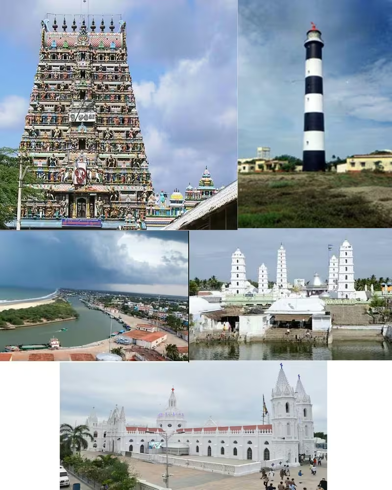
The Soundararajaperumal Temple is dedicated to Vishnu and is recognised as a Divya Desam. Its association with the Nalayira Divya Prabandham connects the temple to the Alvar devotional tradition. Thirumangai Alvar's verses portray an intimate relationship between the devotee and Soundararaja, using the voice of a woman addressing her beloved. The temple is therefore both a place of worship and an important monument in the history of Tamil Vaishnava poetry.
The Kayarohanaswami Temple is dedicated to Shiva and has existed from at least the sixth century according to the historical account of the site. It is praised in the Tevaram hymns of Appar, Campantar and Sundarar. The temple belongs to the Saptha Vidangam group of seven temples associated with the Thyagaraja cult. In this tradition, Thyagaraja is believed to express different styles of dance at each temple. The shrine of Neelayadakshi, the consort of Kayarohanaswami, is another important feature of the temple complex.
Several pilgrimage centres lie close to Nagapattinam. Sikkal is known for the Sikkal Singaravelan Temple. Vedaranyam contains the Vedaranyeswarar Temple. Other important regional temples include the Ettukudi Murugan Temple and the Koothanur Maha Saraswathi Temple. Nagapattinam functions as a base from which visitors reach these sites.
Nagore, located near Nagapattinam, is home to the Nagore Durgha, a sixteenth-century minaret and pilgrimage centre associated with Hajrath Shahul Hamid, who lived from 1490 to 1579. The annual Kanduri festival lasts fourteen days and commemorates the saint's urs, or death anniversary. Pilgrims from different religions participate in the rituals. The festival is regarded as a form of sacred exchange between Hindus and Muslims and as an expression of shared regional life.
The Nagore shrine also illustrates the mixed patronage associated with the site. It is believed that 60 percent of the shrine structures were built by Hindus. The festival attracts domestic and international visitors, while three other prominent mosques serve Muslim communities in Nagapattinam.
Velankanni, about 10 kilometres from Nagapattinam, is another major pilgrimage centre. Its Basilica of Our Lady of Good Health is a Roman Catholic church built during the seventeenth century. Pilgrims visit especially during September, and the visitors include Hindus, Muslims and Christians of different denominations. The town also contains the Lourdhu Madha, Madharasi Madha, T.E.L.C. and Protestant churches.
Economic Role
Fishing is the main occupation of Nagapattinam. Fish caught in the Bay of Bengal are sold through daily and weekly markets, and the town has many ice factories for preserving the catch. The fishing industry suffered severe damage during the 2004 tsunami, when inundation destroyed or damaged large numbers of boats and disrupted coastal communities.
Agriculture is important in the surrounding region, but much agricultural commerce takes place in the town rather than within the urban area itself. Paddy is the principal crop, followed by groundnut, pulses, sugarcane, cotton and sesame. Nagapattinam serves as a retail and provisions centre for nearby towns and villages.
A majority of the town's workers belong to the service sector. Tourism is a major economic driver because Nagapattinam provides access to heritage, temple and pilgrimage destinations including Nagore, Velankanni, Sikkal, Kodikkarai, Vedaranyam, Mannargudi and Tharangambadi.
Industrial activity remains limited. Household production, tailoring, embroidery, plastic wire work and metal manufacturing are among the principal industries. The Cauvery Basin Refinery, also called the Nagapattinam Refinery and operated as a subsidiary of Chennai Petroleum Corporation Limited, was established in 1993 near the town. It is an important contributor to the local economy.
Large-scale industrial expansion is constrained by the town's linear form and by Coastal Regulation Zone regulations, which restrict certain kinds of construction and industrial development near the coast. Nagapattinam therefore continues to depend strongly on fishing, trade, services, agriculture-related commerce and tourism.
Monuments and Architecture
The remains and traditions associated with the Chudamani Vihara are central to Nagapattinam's Buddhist history. The monastery was founded in the eleventh century by the Srivijayan king Sri Mara Vijayattungavarman with the support of Rajaraja Chola I. Its later name, Rajaraja-perumpalli, appears in connection with the reign of Kulottunga I. Although the historical account does not provide a surviving description of the monastery's complete architecture, its foundation demonstrates the international character of the Chola port.
The Kayarohanaswami Temple represents a long Hindu architectural history extending back to the Pallava period. Its inscriptions associate its construction with Narasimha Pallava II, and its religious importance continued through the Chola and later periods. Its association with the Saptha Vidangam tradition and its shrine to Neelayadakshi make it one of Nagapattinam's principal sacred sites.
The Soundararajaperumal Temple belongs to the Vaishnava Divya Desam network. Its references in the Brahmanda Purana and the Nalayira Divya Prabandham connect the building to both scriptural tradition and Tamil devotional poetry.
The Nagore Durgha is a major Islamic pilgrimage monument in the town's wider heritage landscape. Its sixteenth-century minaret and annual Kanduri festival have given Nagore a distinctive place in the religious geography of the Coromandel Coast.
The Basilica of Our Lady of Good Health at Velankanni extends the region's sacred landscape into the history of Christianity. Built during the seventeenth century, it attracts visitors of many faiths, particularly during its September pilgrimage season.
Famous Personalities
Several religious figures are closely associated with Nagapattinam's cultural history. Appar and Tirugnanasambandar, the seventh-century Saiva poet saints, referred to the town as Nagai in their Tevaram verses. Their poems describe its fortifications, roads and port, providing important testimony to the town's early medieval character.
Thirumangai Alvar praised the Soundararajaperumal Temple and helped establish its place within the Divya Desam tradition. His devotional poetry is an important part of Nagapattinam's Vaishnava heritage.
Among the political figures connected to the town are Narasimha Pallava II, during whose reign the Kayarohanaswami Temple was initiated; Rajaraja Chola I, who supported the Chudamani Vihara; Rajendra Chola I, whose eastern naval expeditions used the port; Kulottunga I, during whose reign the monastery was known as Rajaraja-perumpalli; and Sri Mara Vijayattungavarman, the Srivijayan ruler who founded the Buddhist institution.
Hajrath Shahul Hamid, who lived from 1490 to 1579, is associated with the Nagore Durgha. The annual Kanduri festival commemorates his death anniversary and remains a major expression of shared religious participation in the region.
Decline and Revival
Nagapattinam did not disappear after the height of Chola maritime power. Instead, its function changed repeatedly. It remained a port under the Portuguese, Dutch and British, but the commercial networks that sustained it were reshaped by European competition and the rise of other harbours.
The port's decline became more evident after the inclusion of Tranquebar and Tuticorin in the colonial maritime system. Even so, Nagapattinam remained one of the principal ports of the Madras Presidency and an administrative centre under British rule. Its transformation into the headquarters of Tanjore district from 1799 to 1845 illustrates the shift from an exclusively maritime role to a combined administrative and commercial one.
The town's railway history also reflects its changing importance. The Great Southern of India Railway Company had its headquarters at Nagapattinam from 1861 to 1875. A broad-gauge line connected Nagapattinam with Tiruchirappalli Junction through Thiruvarur and Thanjavur. The line was converted to metre gauge in 1875, when the railway headquarters moved to Tiruchirappalli. The railway workshop remained at Negapatnam until 1929, when it was transferred to Golden Rock at Ponmalai.
The 2004 tsunami was the most devastating modern disaster in the town's history. The Indian Ocean earthquake of 26 December 2004 generated tsunamis that struck the shores of the Indian Ocean. Nagapattinam district was the worst-affected part of Tamil Nadu, accounting for 6,064 of the state's 8,009 casualties. Many victims belonged to fishing communities living close to the shore, particularly in Akkaraipattai.
The tsunami damaged boats, interrupted fishing and caused immediate losses in tourism. Salt deposited on paddy fields affected agricultural land. In the town, 40 slums were recorded in 2001, with an estimated 44 percent of residents living in them. Fourteen of these settlements were affected by the tsunami. Grant schemes and tsunami assistance programmes supported their reconstruction, including the building of houses designed to withstand future tsunami risks.
Modern City
Nagapattinam is administered by a special-grade municipality covering 17.92 square kilometres and had a population of 102,905 in the 2011 census. The town recorded a sex ratio of 1,026 females for every 1,000 males. Its average literacy rate was 78.74 percent, higher than the national average recorded in the same census.
The population includes Hindus, Muslims and Christians, as well as very small communities following other religions. In the 2011 religious census, Hindus accounted for 71.4 percent of the population, Muslims 24.79 percent and Christians 3.68 percent. This diversity is visible in the town's temples, mosques, churches and nearby pilgrimage centres.
Road transport is the principal means of access. Nagapattinam is connected by National Highway 45A to Villupuram and National Highway 67 to Coimbatore and Gundlupete in Karnataka. The Tamil Nadu State Transport Corporation operates around 175 daily services to other cities and 25 town bus services for local travel. The State Express Transport Corporation provides long-distance connections.
Nagapattinam Junction connects the town with Thiruvarur Junction, Nagore and Velankanni. Passenger trains serve Tiruchirappalli, Thanjavur, Mayiladuthurai, Karaikal, Mannargudi and Thiruthuraipoondi. There is also a daily express service to Chennai Egmore through Mayiladuthurai and to Ernakulam through Coimbatore, along with the Vasco da Gama–Velankanni Express.
The modern port is located at the mouth of the Kuduvayyar. A river-mouth sandbar protects the port and its dockyard. The harbour handles a limited quantity of edible-oil imports. The Nagapattinam lighthouse, built by the British in 1869, is a 20-metre-high conventional lighthouse within the port premises. The Tamil Nadu Maritime Board maintains the port and lighthouse.
Nagapattinam has elementary, secondary and higher-secondary schools, as well as medical, arts and science, engineering, polytechnic and industrial training institutions. St. Joseph's College was opened in Nagapattinam in 1846 before being transferred to Tiruchirappalli in 1883. In 2012, the Tamil Nadu Government established Tamil Nadu Dr. J. Jayalalithaa Fisheries University in Nagapattinam.
Public services include electricity distributed through the Nagapattinam circle of the Tamil Nadu Electricity Board and water supplied through borewells drawing from the Vettar River. The municipality collects about 55 metric tonnes of solid waste each day. Sewage is handled through septic tanks and public conveniences rather than an underground drainage network, while storm water moves through natural river channels and constructed drains.
Nagapattinam's historical identity remains visible in the relationship between its port, temples, pilgrimage routes, fishing communities and administrative institutions. It is not defined by a single period. The town's significance lies in the way several histories overlap: ancient Tamil commerce, Pallava religious patronage, Chola naval power, Srivijayan Buddhist connections, European colonial rivalry, modern district administration and the continuing life of the Bay of Bengal coast.