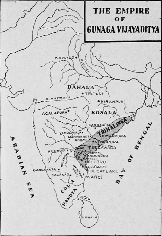
Eastern Chalukya Vengi: A Historical Map of the Eastern Deccan
Introduction
The Eastern Chalukya kingdom took shape in the Vengi region after Pulakeshin II of Badami conquered the eastern Deccan and appointed his brother Kubja Vishnuvardhana as governor in 624 CE. What began as a provincial command gradually developed into a hereditary monarchy with its own political identity. The map of Eastern Chalukya Vengi therefore represents both a territorial kingdom and a long process of political separation from the Chalukyas of Badami.
The dynasty’s centres of power moved from Pishtapura, identified with modern Pitapuram, to Vengi at present-day Pedavegi near Eluru, and later to Rajamahendravaram, now Rajahmundry. These changes reveal the importance of the Vengi region as a connected political landscape rather than a kingdom defined by a single permanent capital. Across roughly five centuries, the Eastern Chalukyas faced pressure from the Rashtrakutas, Pallavas, Cholas, and powerful local nobles, while also supporting the development of Telugu culture, literature, religious institutions, and architecture.
This map covers the period from the establishment of Kubja Vishnuvardhana’s viceroyalty in 624 CE to the later Eastern Chalukya rulers of the 11th and early 12th centuries. The political geography changed repeatedly, and the surviving record does not establish one fixed boundary for the entire dynasty. The mapped territory should therefore be understood as the Vengi heartland and the eastern Deccan sphere associated with Eastern Chalukya authority.
Historical Context
The Eastern Chalukyas emerged from the expansion of the Badami Chalukyas. Pulakeshin II, who ruled from 609 to 642 CE, defeated the remnants of the Vishnukundina dynasty and brought Vengi into the Badami Chalukya sphere. He appointed Kubja Vishnuvardhana, his brother, to govern the newly acquired territory. Kubja Vishnuvardhana became the founder of the Eastern Chalukya line.
The viceroyalty may have become independent after Pulakeshin II died fighting the Pallavas in the Battle of Vatapi. The exact political circumstances of this transition are not fully established, but the result was the emergence of a separate Chalukya power in Vengi. The dynasty’s early identity was connected to the wider Chalukya world of the Deccan. The Timmapuram plates describe the family as belonging to the Manavya gotra and as Haritputras, a lineage claim also associated with the Kadambas and Western Chalukyas. From the 11th century, the dynasty additionally adopted a legendary lunar-dynasty genealogy.
The first decades were unstable. Between 641 and 705 CE, several rulers, apart from Jayasimha I and Mangi Yuvaraja, held the throne for short periods. Family disputes and weak kings disturbed the kingdom. The Rashtrakutas of Malkhed later displaced the Western Chalukyas of Badami and repeatedly overran Vengi. Eastern Chalukya rulers were unable to check this pressure until Gunaga Vijayaditya III came to power in 848 CE.
Gunaga Vijayaditya III occupies a turning point in the political history of Vengi. The Rashtrakuta ruler Amoghavarsha treated him as an ally, and after Amoghavarsha’s death Vijayaditya proclaimed independence. This episode illustrates the changing relationship between Vengi and the larger powers of the Deccan: Eastern Chalukya autonomy could expand when imperial authority weakened, but it remained vulnerable to external intervention and internal division.
The dynasty’s long ruler list also reflects repeated succession crises. It includes Vijayaditya II, Bhima I, Amma II, Danarnava, Jata Choda Bhima, Shaktivarman I, Vimaladitya, and Rajaraja Narendra. The record identifies Jata Choda Bhima as a usurper, while the reigns of several other rulers lasted only months or even days. These abrupt changes affected the stability of the territory and allowed local principalities to gain influence.
Territorial Extent and Boundaries
The Eastern Chalukya kingdom was centred on Vengi in the eastern Deccan, corresponding broadly to the coastal Andhra region of present-day Andhra Pradesh. The map’s core area is therefore placed between the lower eastern Deccan and the coastal plain. Vengi, Pishtapura, and Rajamahendravaram form the main political axis shown here.
The northern frontier cannot be drawn as a single securely fixed line for all periods. The kingdom’s territory was affected by Rashtrakuta intervention and by the power of regional chiefs. The western side connected Vengi with the Deccan plateau and the wider Chalukya political world. This was the direction from which the Badami Chalukya and Rashtrakuta connections were most significant.
The eastern boundary was associated with the coastal side of Andhra, but the available record does not define a continuous maritime frontier or provide a list of ports under direct Eastern Chalukya control. The southern boundary was similarly variable. Pallava and Chola relations influenced the political geography of the region, and the dynasty maintained marital connections with the Cholas.
Vengi was not always governed as a uniformly consolidated territory. The kingdom included many smaller principalities and estates held by collateral branches of the ruling family or by allied families. Elamanchili, Pithapuram, and Mudigonda are named among these centres. Other politically connected houses included the Kona Haihayas, Kalachuris, Kolanu Saronathas, Chagis, Parichedas, Kota Vamsas, Velanadus, and Kondapadamatis.
These local powers occupied an uncertain position between autonomy and allegiance. When the Vengi ruler was strong, the nobility paid allegiance and tribute. When royal authority weakened, local chiefs could join the dynasty’s enemies. The map should consequently distinguish the Vengi core from areas where authority was mediated through subordinate or semi-independent estates. A precise boundary between direct rule, tribute, and local control is not recoverable for every reign.
Administrative Structure
The Eastern Chalukya state was a monarchy shaped by Hindu political philosophy. Inscriptions refer to the traditional seven components of the state, known as the Saptanga, and to eighteen offices or Tirthas. These included the Mantri, or minister; Purohita, or chaplain; Senapati, or military commander; Yuvaraja, or heir apparent; Dauvarika, or door keeper; Pradhana, or chief; and Adhyaksha, or head of a department.
The surviving record names these offices but does not explain in detail how administrative work was organised. It is therefore possible to identify the structure of the court without reconstructing a complete bureaucratic system. The court initially remained closely connected to Badami, but local influences became stronger over the generations and the Vengi monarchy developed features of its own.
Administrative subdivisions included the Vishaya and the Kottam. Karmarashtra and Boya-Kottams are examples recorded in the historical material. Royal edicts, particularly grants of land or villages, were addressed to Naiyogi Kavallabhas, a broad term whose exact duties are unclear, and to the Grameyakas, the residents of the village receiving the grant. The Manneyas appear in some inscriptions as holders of assignments of land or revenue in different villages.
This system combined royal authority, local administration, landholding, and aristocratic power. The nobility was closely tied to the ruling family through collateral descent and marriage. Families that served the crown could also be raised to high position. Such arrangements helped the monarchy govern a fragmented territory, but they also created the possibility of rebellion when the central court was weak.
The sequence of capitals is a major feature of the map. Pishtapura was the original capital. The court later moved to Vengi, and then to Rajamahendravaram. These shifts may be read as changes in the political focus of the kingdom, although the available evidence does not provide a single explanation for each move. Rajamahendravaram is especially associated with Rajaraja Narendra, who ruled in the 11th century and patronised the poet Nannaya.
Infrastructure and Communications
The historical record available for Eastern Chalukya Vengi provides no detailed survey of roads, formal postal systems, or engineered communication networks. The map therefore does not depict a documented road grid or state postal route. Movement nevertheless connected the capitals, estates, religious centres, villages, and neighbouring kingdoms.
The political setting required communication across the eastern Deccan and between the Vengi court and external powers. The Eastern Chalukyas maintained long and intimate contact, both friendly and hostile, with the Pallavas, Rashtrakutas, Cholas, and Chalukyas of Kalyani. Royal grants and administrative orders had to circulate among local officials, village residents, and landholders, indicating the existence of practical channels of communication even though their exact routes are unknown.
The concentration of important centres around the Vengi plain and the Godavari region suggests a landscape in which riverine and overland connections mattered. However, no securely documented trade road or maritime route is identified in the available record. Claims about specific highways, ports, shipping systems, or distances would go beyond the evidence preserved here.
Economic Geography
Agriculture and landholding formed an important part of the Eastern Chalukya political economy. Royal grants transferred villages, land, or revenue assignments to religious institutions, officials, and other beneficiaries. The Manneyas are specifically associated with assignments of land or revenue in different villages. Such grants connected the court with local production and helped sustain religious and administrative establishments.
The Vengi region’s coastal plain and riverine setting supported the concentration of settlements and political centres, although detailed agricultural statistics are not available. The record does not provide estimates of population, crop yields, taxation, or the distribution of natural resources. No secure reconstruction of the kingdom’s demographic geography can therefore be made.
Trade is more clearly represented through the Komati community. The Komatis, identified with the Vaishya social category, formed a flourishing trading group. Their organisation into a powerful guild called the Nakaram had its headquarters at Penugonda in West Godavari and branches in seventeen other centres. This indicates a network of commercial activity extending beyond a single town, even though the names and locations of all seventeen branches are not recorded here.
The administration may have included a Samaya Mantri, or minister for communal affairs, suggesting that organised communities had a recognised place in public life. The record does not identify specific commodities, ports, export markets, or long-distance commercial routes. Penugonda can nevertheless be marked as a major economic centre because of its association with the Nakaram guild.
Cultural and Religious Geography
Hinduism was the prominent religion of the Eastern Chalukya kingdom, and Shaivism was more popular than Vaishnavism. Several rulers described themselves as Parama Maheswaras. Temple institutions were important not only as places of worship but also as centres supporting dancers, musicians, and other fine arts.
The Mahasena temple at Chebrolu became known for its annual jatra. During the procession, the deity’s image was carried from Chebrolu to Vijayawada and back. This movement created a religious connection across the Vengi landscape and is one of the clearest ritual routes associated with the kingdom.
Buddhism, which had been prominent during the Satavahana period, was in decline. Buddhist monasteries were reported to have become largely deserted, although Xuanzang observed approximately twenty or more monasteries with more than three thousand monks. Some Buddhist religious centres later became known as Shaiva pilgrimage centres. The evidence indicates a gradual transformation of the religious landscape rather than the immediate disappearance of Buddhism.
Jainism continued to receive support. Ruined Jain images, inscriptions, temple foundations, and land grants indicate that Jain communities remained present. Kubja Vishnuvardhana, Vishnuvardhana III, and Amma II are associated with Jain patronage, while Vimaladitya became a declared follower of Mahavira’s doctrine. Vijayawada, Jenupadu, Penugonda, and Munugodu were noted Jain centres.
Ambapuram and the hills of Adavinekkalam preserve another aspect of this religious geography. Five Jain caves were constructed there during the 7th and 8th centuries CE. The Ambapuram cave temple is identified as a Jain cave temple constructed under the Eastern Chalukyas.
The dynasty also supported large-scale temple construction. Vijayaditya II was credited with 108 temples. Yuddhamalla I erected a temple to Kartikeya at Vijayawada. Bhima I constructed the Draksharama and Chalukya Bhimavaram temples at Samalkot. Rajaraja Narendra established three memorial shrines at Kalidindi in West Godavari.
Eastern Chalukya architecture drew on Pallava and Chalukya traditions while developing a distinctive regional style. The Pancharama shrines, especially Draksharama, and the temples at Biccavolu are important examples. The Golingesvara temple at Biccavolu contains richly carved representations of Ardhanarisvara, Shiva, Vishnu, Agni, Chamundi, and Surya.
Language and literature provide another major layer of the map. The earliest known Telugu inscriptions of the dynasty include the Vipparla inscription of Jayasimha I and the Lakshmipuram inscription of Mangi Yuvaraja, both from the 7th century. Telugu poetry appears in the Addanki, Kandukur, and Dharmavaram inscriptions of Pandaranga, the army chief of Vijayaditya III, in the later 9th century.
Literary compositions dating before the 11th century are not clearly known, but the court of Rajaraja Narendra became associated with a major development in Telugu literature. Nannaya, his poet-laureate, began translating the Mahabharata into Telugu. The work remained incomplete but was acclaimed as a masterpiece. Narayana Bhatta, proficient in eight languages, assisted him and was granted a village by Rajaraja Narendra in 1053 for his contribution.
The relationship between Kannada and Telugu literary culture was especially close. The Eastern Chalukya connection to the Badami Chalukyas linked Karnataka and Andhra, and several authors wrote in both languages. Nannaya’s Bharata used the Akkara metre, associated with Kannada works, while the same metre appeared in Yuddhamalla’s Bezwada inscription. Kannada poets Adikavi Pampa and Nagavarma I were also connected to families originally from Vengi.
Military Geography
The military geography of Vengi was shaped by dynastic succession, external invasions, and the power of regional estates. The kingdom originated in the conquest of Vengi by Pulakeshin II, followed by the appointment of Kubja Vishnuvardhana. Its early political position was therefore established through military expansion from the western Deccan.
The Battle of Vatapi, in which Pulakeshin II fought the Pallavas and died, forms an important turning point in the dynasty’s origin narrative. Later, the Rashtrakutas of Malkhed repeatedly overran Vengi. Their interventions exposed the vulnerability of the kingdom when the throne was occupied by weak or short-lived rulers.
Gunaga Vijayaditya III restored greater political confidence in 848 CE. His alliance with Amoghavarsha and subsequent declaration of independence demonstrate how diplomacy and military strength worked together. The record does not provide a complete list of battles, troop numbers, fortifications, or army deployments. It does, however, identify the Senapati as a formal office and shows that military commanders could hold considerable status.
Pandaranga, the army chief of Vijayaditya III, is associated with inscriptions containing early Telugu poetry. This connection between military leadership, inscriptional culture, and royal service illustrates the overlapping functions of elite officials.
The nobility also had military significance. Kshatriyas formed the ruling class, and their rivalry contributed to two centuries of civil war. Shudras formed much of the population and frequently entered the army; some rose to the status of Samanta Raju and Mandalika. The army was thus connected to social mobility as well as royal defence.
The smaller principalities of Elamanchili, Pithapuram, Mudigonda, and other houses could support or oppose the royal government. Their allegiance was conditional, making the control of local strongholds and estates central to the kingdom’s military security. A detailed fortress map cannot be reconstructed from the available record, but the political geography clearly shows a state whose defence depended on both the royal army and subordinate chiefs.
Political Geography
The Eastern Chalukyas maintained relationships with nearly every major power surrounding the eastern Deccan. Their first connection was with the Chalukyas of Badami, from whom they originated. Their later history involved repeated contact with the Rashtrakutas, who challenged and at times overran Vengi.
Relations with the Pallavas were both formative and hostile. Pulakeshin II’s conflict with the Pallavas shaped the circumstances in which the Eastern Chalukya viceroyalty may have become independent. The dynasty also maintained long-term contact with the Chalukyas of Kalyani.
The Cholas became increasingly significant. Eastern Chalukya rulers had marital relationships with the Cholas, creating a dynastic connection that affected the political landscape of the eastern Deccan. The available record does not specify each marriage alliance or map its immediate territorial consequences, but the relationship is central to understanding the dynasty’s later political setting.
Within Vengi, the monarchy relied on tribute and allegiance from noble families and local estates. When central authority was strong, these powers supported the royal order. When the throne was weakened by family feuds, short reigns, or foreign invasion, they could cooperate with external enemies. Eastern Chalukya political geography was therefore layered: royal authority, aristocratic estates, religious institutions, village communities, and commercial guilds all occupied distinct but connected positions.
Legacy and Decline
Eastern Chalukya rule shaped the Vengi region for approximately five centuries. Its most lasting contribution was the consolidation of Vengi into a more unified political and cultural region. The dynasty also helped create the conditions for the growth of Telugu inscriptions, poetry, literature, and temple art.
The later period saw a particularly strong efflorescence of Telugu culture. Rajaraja Narendra’s patronage of Nannaya and the beginning of the Telugu Mahabharata marked a major literary development. Architectural traditions visible at Draksharama, Biccavolu, Samalkot, and other centres likewise preserve the regional expression of Eastern Chalukya power.
Political instability remained a recurring weakness. Fratricidal wars, rival claimants, usurpation, and the autonomy of local nobles repeatedly reduced central control. After the decline of Rashtrakuta power, the Kakatiyas, formerly vassals of the Western Chalukyas, assumed sovereignty by suppressing other Chalukya subordinates in Telangana. This broader reorganisation of power contributed to the transformation of the political landscape around Vengi.
The final rulers listed include Shaktivarman I, Vimaladitya, Rajaraja Narendra, Shaktivarman II, Vijayaditya VII, Rajaraja II, and Virachola Vishnuvardhana IX, whose reign extended to 1102 CE. The dynasty’s territorial configuration therefore changed over time, but its capitals, temples, inscriptions, commercial institutions, and literary achievements continued to define the historical identity of coastal Andhra and the eastern Deccan.