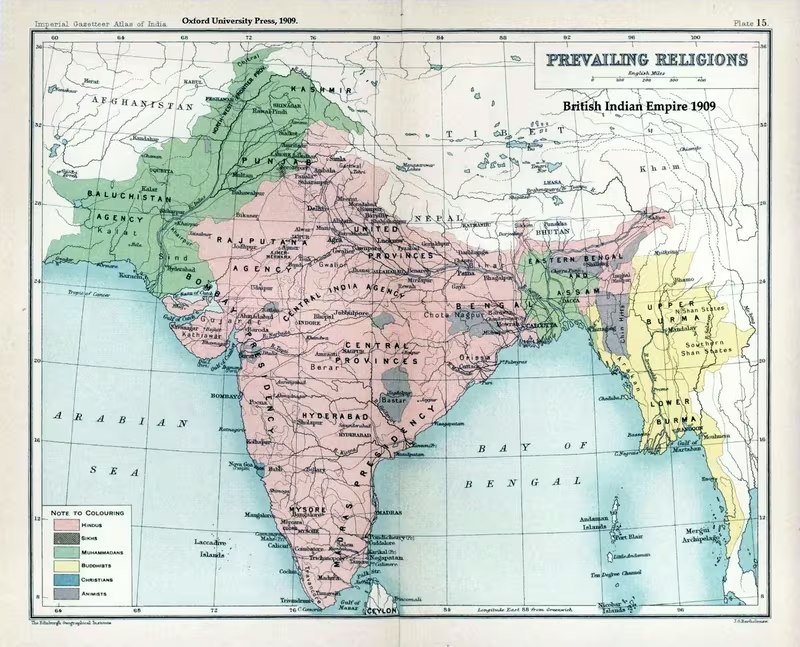
Partition of India and Pakistan, 1947
Introduction
At midnight between 14 and 15 August 1947, British India ceased to exist as a single imperial territory. Two new dominions emerged: India, with independence ceremonies centred in New Delhi on 15 August, and Pakistan, inaugurated on 14 August with Muhammad Ali Jinnah sworn in as its first Governor-General in Karachi. The map of this moment is therefore not simply a boundary map. It records the break-up of British rule, the division of Punjab and Bengal, the uncertain status of princely states, and the movement of millions of people across borders that had been created with extraordinary speed.
The territorial division was set out through the Indian Independence Act 1947 and implemented through the Mountbatten Plan, also called the 3 June Plan. Predominantly Hindu and Sikh areas were assigned to India, while predominantly Muslim areas were assigned to Pakistan. This principle was applied most dramatically to Punjab and Bengal, two large provinces whose districts contained mixed populations. The eventual boundary, prepared under the chairmanship of the British barrister Sir Cyril Radcliffe, became known as the Radcliffe Line.
The map also represents a humanitarian catastrophe. Between 12 and 20 million people were displaced along religious lines, while estimates of deaths in partition-related violence range from 200,000 to two million. The largest movements took place across Punjab and Bengal, but Delhi, Sindh, Gujarat, Jammu, Kashmir, Bihar, the United Provinces, Assam, and other regions were also transformed. The map's borders should therefore be read alongside its migration routes: political separation and population movement were inseparable features of 1947.
Historical Context
From colonial provinces to competing political visions
The 1947 partition had several political precedents. In 1905, Viceroy Lord Curzon divided Bengal into the Muslim-majority province of Eastern Bengal and Assam and the Hindu-majority province of Bengal. The decision provoked a predominantly Hindu protest, including the Swadeshi boycott of British goods and political violence. The partition was annulled in 1911, but the episode altered nationalist politics and deepened Muslim concerns about representation in a political system increasingly organised around majorities.
In 1906, Muslim leaders approached Viceroy Lord Minto for separate electorates and representation proportionate to the Muslim population. The All-India Muslim League was founded at Dacca in December of that year. The League initially represented a limited political constituency, but its significance increased as constitutional reforms, elections, and debates over self-government made questions of communal representation more consequential.
The 1916 Lucknow Pact marked an important period of cooperation between the Indian National Congress and the Muslim League. Congress accepted separate Muslim electorates in provincial legislatures and the Imperial Legislative Council in exchange for joint support for expanded self-government. The pact was later criticised as benefiting Muslim minority elites in provinces such as the United Provinces and Bihar more than Muslim-majority populations in Punjab and Bengal.
The Government of India Act 1919 expanded legislative councils and introduced dyarchy in the provinces. Some responsibilities, including education, agriculture, public health, and local government, were transferred to Indian ministers and legislatures, while police, prisons, land revenue, irrigation, and media remained under British authority. The system widened participation without transferring full power.
The Government of India Act 1935 went further by introducing provincial autonomy and expanding the electorate. For the first time, law and order was devolved to provincial governments led by Indians. These reforms made the question of future majority rule more immediate. Many Muslim politicians feared that an independent India dominated by Congress would produce Hindu political supremacy, while Congress continued to claim that it represented Indians of every faith.
The two-nation theory and the Pakistan demand
During the 1920s and 1930s, several political figures articulated versions of the idea that Hindus and Muslims constituted distinct nations. Lala Lajpat Rai proposed a division between a Muslim India and a non-Muslim India in 1924. Vinayak Damodar Savarkar expressed a different form of the theory in his 1923 work Essentials of Hindutva and declared in 1937 that Hindus and Muslims were two nations.
Choudhry Rahmat Ali used the name Pakistan in a 1933 pamphlet. He formed the name from Punjab, the North-West Frontier Province, Kashmir, Sindh, and Balochistan. At that stage, the proposal attracted little political support and was described by a Muslim delegation to a British constitutional committee as impracticable.
The 1937 provincial elections changed the political balance. Congress won 716 of the 1,585 provincial assembly seats and formed governments in seven of British India's eleven provinces. The Muslim League performed strongly in Muslim-minority areas such as the United Provinces, but regional parties remained more powerful in Muslim-majority Punjab and Bengal. In Punjab, the Unionist Party formed a government with Congress and the Shiromani Akali Dal. In Bengal, the Muslim League shared power in a coalition headed by A. K. Fazlul Huq.
Congress's refusal to form a coalition with the Muslim League in the United Provinces unless the League stopped acting as an exclusively Muslim representative further alienated League leaders. The League's subsequent investigations into Muslim conditions in Congress-ruled provinces reinforced fears of future Hindu domination. These developments helped the League present itself as the principal representative of Muslim India.
War and the growth of the Muslim League
In 1939, Viceroy Lord Linlithgow declared India at war without consulting Indian leaders. Congress provincial ministries resigned in protest. The Muslim League, by contrast, celebrated a “Deliverance Day” from Congress rule and supported the British war effort. The political contrast gave the League greater freedom to organise while Congress leaders were later imprisoned.
At the League's Lahore session in March 1940, Muhammad Ali Jinnah presented the argument that Hindus and Muslims were separate political communities. The League adopted the Lahore Resolution, calling for Muslim-majority areas in the north-western and eastern zones of India to be grouped into independent states whose constituent units would be autonomous and sovereign. The resolution did not initially provide a single, precisely bounded state, but it became the central political statement of the Pakistan Movement.
The August Offer of 1940 and the Cripps Mission of 1942 failed to resolve the constitutional question. The Cripps proposals allowed provinces not to join a future Indian dominion, but the Muslim League considered this insufficient. Congress rejected the proposals because it saw itself as the representative of all Indians and opposed arrangements that could weaken a united centre.
In August 1942, Congress launched the Quit India movement. Its leading figures were imprisoned until 1945, while the Muslim League remained free to expand its organisation. The League's membership and political reach increased during the war, and British officials increasingly treated Jinnah and the League as the main political voice of Muslim India.
The elections of 1946 and the collapse of compromise
After Labour came to power in Britain in 1945, the government decided to transfer power in India no later than June 1948. A Cabinet Mission led by Lord Pethick-Lawrence, with Stafford Cripps among its members, was sent to negotiate an orderly transition.
The 1946 elections gave Congress an overwhelming mandate in non-Muslim constituencies. It won 91 percent of the vote in those constituencies, secured a majority in the Central Legislature, and formed governments in eight provinces. The Muslim League won most Muslim votes, most reserved Muslim seats in provincial assemblies, and all Muslim seats in the Central Assembly. The election results strengthened the claims of both parties while making a shared constitutional settlement more difficult.
The Cabinet Mission Plan proposed a federal India with three provincial groups. Two groups would consist mainly of Muslim-majority provinces, while the third would consist mainly of Hindu-majority regions. The centre would control defence, foreign affairs, and communications, while provinces would retain substantial autonomy. The Muslim League accepted the plan, seeing it as a possible route to the substance of Pakistan. Congress leaders, particularly Jawaharlal Nehru, feared that the arrangement would create a weak centre. On 10 July 1946, Nehru rejected the idea that provinces would be permanently bound by the proposed groupings. The plan consequently collapsed.
Direct Action Day and the escalation of violence
After the Cabinet Mission failed, Jinnah announced that the Muslim League would begin a struggle for Pakistan. He designated 16 August 1946 as Direct Action Day. In Calcutta, large crowds gathered around the Ochterlony Monument. Violence began that day and continued for three days. Official accounts recorded approximately 4,000 deaths, with both Hindus and Muslims among the victims.
The violence spread beyond Bengal. Muslims were attacked in Bihar; Hindus were attacked in Noakhali; Hindus attacked Muslims in Garhmukteshwar in the United Provinces; and in March 1947 Hindus and Sikhs were attacked or driven out in Rawalpindi. The breakdown of order made a united constitutional settlement increasingly difficult.
The 3 June Plan and the Creation of Two Dominions
Lord Louis Mountbatten became the last Viceroy of British India with instructions to transfer power by June 1948 while trying to preserve a united India. The worsening communal situation led him to conclude that partition was necessary for a rapid British withdrawal. He advanced the transfer of power and presented the plan on 3 June 1947.
The plan provided that:
- The Punjab and Bengal legislative assemblies would vote on partition.
- If the relevant groups voted for division, the provinces would be split.
- Sind and Baluchistan would decide their own political futures.
- The fate of the North-West Frontier Province and Sylhet district of Assam would be determined by referendums.
- An independent Bengal would not be created.
- Boundary commissions would be established if partition took place.
- The princely states would be advised to accede to India or Pakistan rather than remain independent.
Congress accepted the plan on 2 June. The Muslim League's demand for a separate country was recognised, while Congress sought to limit Pakistan's territorial extent and preserve as much of India's unity as possible. The Indian Independence Act was passed by the British Parliament on 18 July 1947. It ended British suzerainty over the princely states and created the legal framework for the two new dominions.
Territorial Extent and Boundaries
India and Pakistan
The 1947 map shows two new dominions formed from the territories of British India. India occupied the predominantly Hindu-majority regions, while Pakistan consisted of predominantly Muslim-majority areas. Pakistan was not a single contiguous territory. It had:
- West Pakistan, comprising the western regions of the former British Indian Empire.
- East Pakistan, comprising East Bengal and separated from West Pakistan by Indian territory.
This geographical separation remained a defining feature of the 1947 map. East Pakistan later became Bangladesh after the Bangladesh Liberation War in 1971. That later secession was a partition of Pakistan, not a further partition of British India.
The 1947 partition did not include Burma, which had already been separated from the administration of British India. It also did not include Ceylon, later Sri Lanka, or the incorporation of French India into India between 1947 and 1954. Goa and other Portuguese territories were annexed by India in 1961, outside the events represented by this map. Sikkim, Bhutan, Nepal, and the Maldives were also unaffected by the partition.
Punjab
Punjab was divided between the two dominions. Its western, predominantly Muslim areas became part of Pakistan's Punjab province. Its eastern, predominantly Hindu and Sikh areas became India's East Punjab, later reorganised into Punjab, Haryana, and Himachal Pradesh.
Punjab's geography was structured by five major rivers: the Jhelum, Chenab, Ravi, Beas, and Sutlej. The region was divided into inter-fluvial doabs:
- The Sindh-Sagar Doab, between the Indus and Jhelum.
- The Jech Doab, between the Jhelum and Chenab.
- The Rechna Doab, between the Chenab and Ravi.
- The Bari Doab, between the Ravi and Beas.
- The Bist Doab, between the Beas and Sutlej.
The most disputed areas in early 1947 were in the Bari and Bist doabs. Districts including Gurdaspur, Amritsar, Lahore, and Montgomery were contested. Apart from Amritsar, which was 46.5 percent Muslim, the disputed districts had Muslim majorities. Gurdaspur's Muslim majority was narrow, at 51.1 percent.
At the smaller tehsil level, the situation was even more complex. Pathankot, in northern Gurdaspur, had a non-Muslim majority. Amritsar and Tarn Taran, in Amritsar district, also had non-Muslim majorities. At the same time, four Muslim-majority tehsils lay east of the Beas-Sutlej line. The boundary could not therefore be drawn by following a single river or a simple provincial division.
Bengal
Bengal was divided into West Bengal, assigned to India, and East Bengal, assigned to Pakistan. East Bengal was renamed East Pakistan in 1955 and later became Bangladesh.
The boundary did not follow religious majorities in a uniform way. Murshidabad and Malda, located on the right bank of the Ganges and containing Muslim majorities, were assigned to India. Khulna, a Hindu-majority district at the mouths of the Ganges and surrounded by Muslim-majority districts, was assigned to Pakistan. The Chittagong Hill Tracts, whose population was recorded as 98.5 percent Buddhist in 1947, were also assigned to Pakistan.
The Bengal division created new minority problems. Hindus in districts assigned to Pakistan faced attacks and persecution, prompting large-scale movement into India. Many Muslims left Calcutta for East Pakistan, while refugee families occupied abandoned houses and properties. Bengal's migration was less sudden and less completely organised than Punjab's, but it continued for years after independence.
Sindh
Sindh became part of Pakistan. Unlike Punjab and Bengal, it did not initially experience comparable mass violence. Sindh's prosperous upper and middle classes were largely Hindu, and Hindus formed urban majorities in Hyderabad, Karachi, Shikarpur, and Sukkur.
The arrival of Muslim refugees from India altered the situation. Refugees entered crowded camps, and communal violence in Ajmer in December 1947 was followed by anti-Hindu riots in Hyderabad, Sindh. Anti-Hindu riots also broke out in Karachi on 6 January 1948. An estimated 1.2 to 1.4 million Hindus migrated from Sindh to India, primarily by train or ship, although a substantial Sindhi Hindu population remained in Sindh.
North-West Frontier Province, Baluchistan, and other regions
The 3 June Plan assigned separate decisions to the North-West Frontier Province and Baluchistan. The Muslim-majority western regions were incorporated into Pakistan, although political views within the North-West Frontier Province were not uniform. The province included the pro-Congress Khudai Khidmatgar movement, while the Muslim League increasingly became the principal political representative recognised by the British.
The map also records the wider consequences of partition in Gujarat, the United Provinces, Bihar, Rajputana, Delhi, Assam, and Jammu and Kashmir. These regions were not all divided by a new international boundary, but they were affected by refugee settlement, communal violence, or disputes over accession.
The Radcliffe Line
The boundary between India and Pakistan was prepared by commissions chaired by Sir Cyril Radcliffe. In both Punjab and Bengal, the commissions included two Muslim and two non-Muslim judges, with Radcliffe as common chairman. The commissions were instructed to identify contiguous majority areas of Muslims and non-Muslims while also considering other factors.
The process did not operate as a negotiated compromise. Each side presented its claims through counsel, and the judges frequently divided two to two on major issues, leaving Radcliffe to make the final decisions. The Punjab and Bengal boundaries consequently reflected district and tehsil majorities, competing political claims, administrative considerations, and the difficult geography of mixed populations.
The Radcliffe Line was announced on 17 August 1947, two days after India had become independent and three days after Pakistan's independence. This delay had major consequences. India and Pakistan became independent before the public knew the exact location of their international boundary. Governments that were still forming had to confront violence, migration, and the administration of new borderlands without a settled public map.
The publication of the boundary was followed by severe violence. Historians have described massacres involving killings, mutilation, destruction of homes, and attacks on women and children. The scale and brutality of the violence were unprecedented in the history of earlier communal riots in the region, although scholars differ over whether the violence should be described as genocide.
Administrative Structure
The two dominions
British India had been governed through a central administration, provinces, and a large collection of princely states. Partition divided central institutions as well as territory. The British Indian Army, Royal Indian Navy, Indian Civil Service, railways, and central treasury were divided between India and Pakistan.
The Dominion of Pakistan came into existence on 14 August 1947. Jinnah became its first Governor-General, and Karachi served as the location of the initial independence ceremonies. The Dominion of India became independent on 15 August. Jawaharlal Nehru became prime minister, and New Delhi was the centre of the new Indian government.
India retained the existing seat of British India at the United Nations, since British India had been a founding member in 1945. Pakistan applied for membership and was admitted by the General Assembly on 30 September 1947.
Provinces and new administrations
Partition did not create two perfectly uniform national territories. The new states inherited provincial administrative structures and had to decide how the old provinces would be divided. Punjab and Bengal were the clearest examples, but the status of Sind, Baluchistan, the North-West Frontier Province, Sylhet, and the princely states also required separate decisions.
The administrative transition was especially difficult because the new governments had not expected a population transfer on the scale that occurred. Refugees arrived in cities, military installations, religious buildings, colleges, gardens, and temporary camps. The government of India later established permanent housing and rehabilitation programmes, while Pakistan undertook its own refugee settlement measures.
The princely states
The Indian Independence Act ended British paramountcy over the princely states. The rulers were released from subsidiary alliances and other obligations to Britain, while Britain withdrew its obligations to them. In theory, each state could accede to India, accede to Pakistan, or attempt to remain independent.
Sardar Vallabhbhai Patel described the consequence of the lapse of paramountcy by saying that every Indian state became a separate independent entity. Political integration began through numerous accessions in August 1947 but continued afterward. The rulers of Hyderabad and Jammu and Kashmir, among others, initially chose independence. The map therefore contains a zone of political uncertainty rather than a complete set of settled national boundaries.
Mountbatten advised the princes against remaining independent and urged them to join one of the two dominions. The eventual integration of the states was central to the creation of the territorial India and Pakistan known after 1947, but the accession process was not completed at the moment of independence.
Infrastructure and Communications
Partition divided not only land but also the systems that connected British India. The railways, central treasury, civil service, army, and navy all had to be divided. This administrative separation affected the movement of officials, soldiers, refugees, food, supplies, and records.
Railways became crucial to migration. Trains carried large numbers of displaced people across Punjab and between India and Pakistan, but they also became associated with violence. In Bengal and Sindh, ships and railways were used by refugees moving toward India or Pakistan. The scale of movement overwhelmed the administrative capacity of both new governments.
The division also disrupted communications between the two wings of Pakistan. East Pakistan and West Pakistan were separated by Indian territory, requiring long-distance connections across or around India. This geographical arrangement had lasting political consequences, although the 1947 map represents only the initial creation of the two-wing state.
The absence of a public boundary before independence created an additional communications crisis. Political leaders knew that partition had been accepted, but the precise line dividing Punjab and Bengal was not announced until 17 August. Refugees, local officials, security forces, and communities therefore faced uncertainty during the most dangerous phase of the transition.
Economic Geography
Divided agricultural regions
Punjab and Bengal were not only politically important provinces; they were also major agricultural regions whose irrigation, markets, transport links, and urban centres crossed the new boundary. The division of Punjab cut through the river-based doab system. Districts, tehsils, villages, canals, roads, and railway lines could fall on different sides of the Radcliffe Line.
Bengal's economy was similarly connected across the province. The new boundary divided communities and markets while assigning districts with different religious majorities to different dominions. The assignment of Khulna to Pakistan and Murshidabad and Malda to India illustrates why the map cannot be understood through a simple east-west division.
Cities and commercial centres
Karachi became the first capital of Pakistan and received a large influx of Muslim refugees, especially from Gujarat, Bombay, the United Provinces, Delhi, Bhopal, Hyderabad, Madras, and Mysore. Delhi received approximately 500,000 Hindu and Sikh migrants from Pakistan while around 330,000 Muslims moved from Delhi to Pakistan, according to estimates cited for total migration in the city.
Calcutta was transformed by migration from East Bengal. Large numbers of Hindu refugees entered the city, while many Muslims left for East Pakistan. Sindh's cities, including Karachi, Hyderabad, Shikarpur, and Sukkur, also underwent major demographic change as Hindu residents departed and Muslim refugees arrived.
Refugee settlement and economic reconstruction
In India, refugee settlement reshaped urban geography. Delhi neighbourhoods such as Lajpat Nagar, Patel Nagar, Rajinder Nagar, Nizamuddin East, Punjabi Bagh, Rehgar Pura, Jangpura, and Kingsway Camp developed or expanded during the resettlement period. Camps in locations such as Purana Qila, Red Fort, military barracks, and Kingsway Camp housed displaced people before permanent housing projects were built.
Sindhi Hindu refugees were settled mainly in Gujarat, Maharashtra, and Rajasthan, with additional settlements in Madhya Pradesh and Delhi. The township of Ulhasnagar in Maharashtra was established for Sindhi Hindu refugees. Punjabi Hindu and Sikh refugees were settled across East Punjab, Delhi, western and central Uttar Pradesh, and other parts of India.
Pakistan received the largest number of refugees in West Punjab, especially from East Punjab and nearby areas of Rajputana. Sindh received the second-largest number, with Karachi absorbing a significant share. East Bengal received refugees from West Bengal, Bihar, and Assam.
Cultural and Religious Geography
Partition was organised around religious majorities, but the social geography of the subcontinent was not neatly divided into separate religious territories. Hindus, Muslims, Sikhs, Buddhists, and other communities lived throughout the provinces that were divided. The new boundaries therefore created large minorities on both sides.
The Punjab division left many Hindus and Sikhs in areas assigned to Pakistan and many Muslims in areas assigned to India. In Bengal, the boundary similarly placed religious minorities on the opposite side of the new international border. The Chittagong Hill Tracts demonstrated the limits of a purely religious-majority principle: the territory had a recorded Buddhist majority of 98.5 percent but was assigned to Pakistan.
Delhi's cultural geography changed sharply. The city had been associated with the Mughal Empire and earlier Muslim rulers, and the 1941 census recorded a Muslim population of 33.2 percent. Refugee arrivals, Muslim departures, and violence altered the city's neighbourhoods and institutions. Historical sites such as Purana Qila, Idgah, and Nizamuddin were used as refugee camps.
Partition also reshaped language and regional identity. Punjabi refugees helped create neighbourhoods with a distinct Punjabi character in Delhi and elsewhere. Sindhi refugees built new communities in western and central India. Bengali refugees settled in West Bengal, Assam, Tripura, Bihar, Odisha, Madhya Pradesh, and the Andaman Islands. These movements created new cultural landscapes rather than simply transferring populations from one state to another.
Military Geography
Division of the armed forces
The British Indian Army and Royal Indian Navy were divided between India and Pakistan. This process occurred while violence was spreading across Punjab, Bengal, Delhi, Jammu, Sindh, and other regions. The new governments inherited armed forces that were themselves being reorganised along new national lines.
The British withdrawal also meant that the colonial government no longer provided a single military authority across the subcontinent. Local administrations, provincial governments, princely-state forces, political organisations, and newly formed national security structures all operated in an unstable environment.
Punjab as the principal zone of violence
Punjab was the most heavily affected region. Approximately 12 million people crossed the Punjab border: around 6.5 million Muslims moved into West Punjab, while approximately 4.7 million Hindus and Sikhs moved into East Punjab. The violence included massacres, forced expulsions, destruction of villages, and attacks on refugee columns.
The Punjab border was strategically important because it crossed major river plains and dense settlement zones. The contested districts of Gurdaspur, Amritsar, Lahore, and Montgomery were especially significant. The allocation of Gurdaspur, with its narrow Muslim majority, was among the issues that attracted intense attention before the boundary was finalised.
Jammu and Kashmir
Jammu and Kashmir remained one of the most contested princely states. Its ruler, Hari Singh, initially chose independence. In the Jammu region, violence between September and November 1947 resulted in the killing and expulsion of large numbers of Muslims. Later violence in Rajouri and Mirpur included attacks by Pashtun tribal militias and Pakistani soldiers against Hindus and Sikhs.
The status of Jammu and Kashmir illustrates why the 1947 map cannot be reduced to the Radcliffe Line. The princely states had not automatically become part of either dominion when British paramountcy ended. Their rulers' decisions, local populations, military forces, and regional political movements shaped the subsequent territorial conflict.
Princely-state forces and local violence
In several princely states, rulers or state officials were accused of failing to prevent violence or of supporting communal cleansing. In Patiala and Faridkot, the return or intervention of rulers was associated with a decline in violence, while accounts of Alwar, Bharatpur, and other states describe organised attacks against Muslim communities.
In Alwar and Bharatpur, Muslim Meos were attacked by organised groups of Hindu Jats, Ahirs, and Gurjars. More than 100,000 Meos were forced to flee, and approximately 30,000 are said to have been massacred. These events demonstrate that the geography of partition-related violence extended beyond the formal international boundary.
Political Geography
Congress, the Muslim League, and the new states
The political geography of 1947 was shaped by the competing claims of Congress and the Muslim League. Congress sought a united India with a strong centre and claimed to represent all religious communities. The Muslim League argued that Muslims constituted a separate nation and demanded political sovereignty for Muslim-majority regions.
The Cabinet Mission Plan attempted to reconcile the two positions through a weak federal centre and grouped provinces. Its failure removed the last major constitutional framework that might have preserved a united India while granting substantial autonomy to Muslim-majority regions.
The Mountbatten Plan therefore converted a constitutional dispute into territorial division. Pakistan was created from Muslim-majority areas in the north-west and east, while India retained the majority of the former British Indian territory. The resulting map reflected both the League's demand for Pakistan and Congress's effort to limit the extent of the new state.
Neighbouring and unaffected political entities
The partition occurred within a wider South Asian political landscape. Nepal, Bhutan, Sikkim, and the Maldives were unaffected. Burma and Ceylon had already been separated from British Indian administration. French and Portuguese possessions were not incorporated into India in 1947; French India joined India between 1947 and 1954, while Goa and other Portuguese territories were annexed in 1961.
The existence of these territories matters for historical map reading. A map of the 1947 partition should not colour every region of the subcontinent as part of India or Pakistan. It represents the division of British India and the political changes directly associated with independence.
Accession and the unresolved states
The princely states were formally released from British paramountcy. Their rulers had to decide whether to accede to India, accede to Pakistan, or seek independence. Many accessions began in August 1947, but political integration continued later.
Hyderabad and Jammu and Kashmir were among the states whose rulers initially chose independence. The uncertainty surrounding accession created new political and military conflicts after the dominions were established. As a result, the 1947 map contains both settled boundaries and unresolved spaces whose future was not yet determined.
Migration and Displacement
The movement of people is one of the map's most important layers. Estimates place total displacement between 12 and 20 million. A population exchange had not been planned in the original partition scheme. Religious minorities were initially expected to remain where they lived, except that the violence in Punjab led to an organised transfer of populations there.
The 1951 Census of Pakistan recorded 7,226,600 displaced people, presumed to be Muslims who had entered Pakistan from India. The 1951 Census of India recorded 7,295,870 displaced persons, apparently mainly Hindus and Sikhs who had moved from Pakistan to India. These figures do not represent the full complexity of migration, and estimates of missing people in the Punjab borderlands suggest that many who left their districts did not appear in the expected destination records.
Punjab migration
Punjab experienced the largest and most concentrated movement. Around 6.5 million Muslims moved into West Punjab, while about 4.7 million Hindus and Sikhs moved into East Punjab. The movement was accompanied by mass violence and the near disappearance of many religious minorities from particular areas.
Estimates for total deaths vary sharply. Some accounts place deaths at approximately one million, while the wider range extends from 200,000 to two million. Punjab was generally identified as the region with the worst violence.
Bengal migration
Bengal's partition produced an estimated 3.3 million cross-border migrants. Approximately 2.6 million Hindus moved from East Pakistan to India, while around 700,000 Muslims moved from India to East Pakistan. Unlike the sudden movement in Punjab, migration from East Bengal continued in waves after independence.
Refugees from East Pakistan settled especially in West Bengal, Assam, Tripura, Bihar, Odisha, Madhya Pradesh, the Andaman Islands, and other parts of India. The long duration of this movement meant that the demographic consequences of Bengal's partition continued well beyond 1947.
Delhi, Gujarat, and Sindh
Delhi's population rose from 917,939 in the 1941 census to 1,744,072 in 1951, despite the departure of many Muslims. Approximately 500,000 Hindus and Sikhs migrated to Delhi, while around 330,000 Muslims moved to Pakistan.
Gujarat received more than one million refugees, including Hindu refugees from Sindh and Gujarati-speaking communities. Around 642,000 Muslims from Gujarat migrated to Pakistan, with approximately 75 percent going to Karachi, partly because of business connections.
Sindh experienced an estimated Hindu migration of 1.2 to 1.4 million people, primarily by train or ship. Although cities changed dramatically, Hindu communities continued to live in Sindh, particularly in districts such as Tharparkar, Umerkot, Mirpurkhas, Sanghar, and Badin.
The Human Cost and Rehabilitation
The new governments were unprepared for the scale of displacement. Refugees lived in camps, military barracks, colleges, temples, gurdwaras, dharmshalas, gardens, and historic buildings. The movement created immediate crises involving food, shelter, health, property, employment, and security.
In January 1948, Mahatma Gandhi fasted to stop communal violence. Religious and political representatives gathered at Birla House and pledged to support peace and unity. Gandhi ended the fast on 18 January after accepting assurances that violence would stop. His intervention is credited with helping end violence in Delhi.
Women suffered abduction, rape, forced conversion, and separation from their families. The Indian government claimed that 33,000 Hindu and Sikh women had been abducted, while the Pakistani government claimed that 50,000 Muslim women had been abducted. By 1949, legal claims recorded the recovery of approximately 12,000 women in India and 6,000 in Pakistan. By 1954, the recorded numbers had risen to 20,728 Muslim women recovered from India and 9,032 Hindu and Sikh women recovered from Pakistan.
Not all recovered women returned to their former homes. Some refused repatriation because they feared rejection by their families. The social effects of partition were not exclusively destructive in every setting. In Bengal and Punjab, some refugee women entered paid work, public life, education, and political movements as traditional family structures changed.
Legacy and Later Change
The territorial configuration created in August 1947 did not remain unchanged. Pakistan's two wings continued as West Pakistan and East Pakistan until the Bangladesh Liberation War of 1971, when East Pakistan became Bangladesh. This was a later partition of Pakistan rather than a further division of British India.
The princely states were gradually integrated into India and Pakistan, although the accession of Jammu and Kashmir produced a continuing dispute. The borderlands of Punjab and Bengal remained politically sensitive, and migration continued after the first months of independence. Indian Muslims continued to migrate to Pakistan in later decades, while Hindus continued to leave Pakistan for India in response to persecution and insecurity.
Partition also shaped the political relationship between India and Pakistan. The violence of 1947 created hostility and suspicion that continued into later conflicts. The existence of religious minorities on both sides, rather than a complete population exchange, remained a source of political argument. B. R. Ambedkar and Sardar Patel supported a complete exchange as a possible solution to communal conflict, while Jawaharlal Nehru and Mahatma Gandhi opposed compulsory population transfer and defended the idea of a secular India in which Muslims could remain equal citizens.
The partition remains contested in historical interpretation. Some historians emphasise British haste and the failure of the colonial administration to maintain order. Others argue that the rapidly worsening communal situation left Mountbatten with few alternatives. Some scholarship stresses the political appeal of Pakistan as a sovereign Muslim state, while other interpretations focus on the possibility of a shared Indian nation containing both Hindus and Muslims. The map cannot settle these debates, but it can show the territorial consequences of the decisions taken in 1947.
Reading the Map
A map of the Partition of India should be read through several overlapping layers:
- The political division: British India became the Dominion of India and the Dominion of Pakistan.
- The provincial division: Punjab and Bengal were divided, while Sind and Baluchistan made separate decisions and the North-West Frontier Province and Sylhet were subject to referendums.
- The international boundary: The Radcliffe Line was drawn through regions of mixed settlement and announced on 17 August 1947.
- The princely-state question: Hundreds of states were released from British paramountcy and had to decide their political futures.
- The migration routes: Millions moved across the new borders, particularly in Punjab and Bengal.
- The violence zones: Punjab, Bengal, Delhi, Sindh, Jammu, Alwar, Bharatpur, and other regions experienced communal violence or displacement.
- The unfinished geography: Jammu and Kashmir and several princely states remained politically unsettled when independence was proclaimed.
The 1947 map therefore represents both creation and rupture. It shows the birth of India and Pakistan, but also the disappearance of a shared administrative framework, the division of provinces and institutions, the movement of populations, and the emergence of disputes that continued long after independence.