Overview
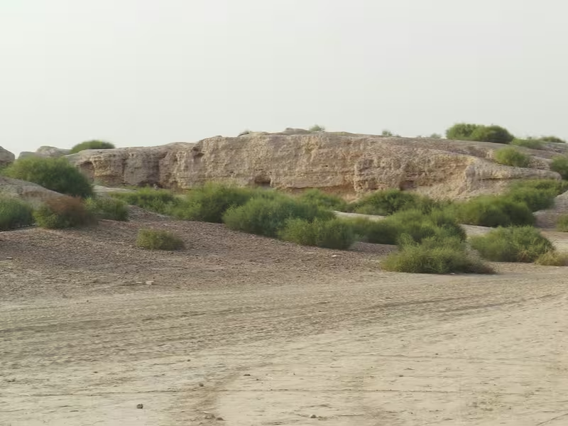
South of the Ghaggar, in present-day Hanumangarh district of Rajasthan, two ancient mounds preserve the remains of Kalibangan. The smaller western mound rises about 9 metres and was identified as a citadel; the larger eastern mound, about 12 metres high, formed the lower city. Together, they reveal a settlement that passed through an Early Harappan phase and a later Harappan urban phase.
Kalibangan is especially valuable because the site preserves several different dimensions of early urban life in one archaeological landscape. Its remains include mud-brick fortifications, carefully aligned streets, houses arranged around courtyards, wells, drains, fire altars, specialized pottery, seals, ornaments, burial grounds, and agricultural traces. The site is also associated with the earliest archaeologically attested ploughed field described in the excavation literature.
The settlement’s history was not a single episode of urban growth. Archaeologists identified a lower cultural phase connected with the Sothi-Siswal tradition and an upper Harappan phase. The earlier settlement was fortified from the beginning of occupation, rebuilt, and eventually abandoned—possibly after an earthquake around 2600 BCE. A Harappan settlement was then established again at the site. The final abandonment of the Mature Harappan settlement has been connected by some researchers with the drying of the Ghaggar, identified in older discussions with the Sarasvati, though this interpretation remains an argument made by particular scholars rather than a settled fact.
The Archaeological Survey of India’s full excavation report was published in 2003, thirty-four years after the fieldwork ended. It concluded that Kalibangan had been a major provincial capital of the Indus Valley Civilization. Its importance rests not only on monumental remains but also on the evidence of everyday organization: where people built houses, how they laid out streets, how they managed household drainage, how they cultivated land, and how they buried or commemorated their dead.
Etymology and Names
The modern name Kalibangan is generally translated as “black bangles.” In the local Bagri language, kālā means black and bangan means bangles. The name is associated with the large number of terracotta bangles found at the site. A nearby railway station and township called Pilibangan is explained in contrast as “yellow bangles,” with pili meaning yellow.
The name belongs to the modern landscape rather than to a securely known ancient name. The people who lived at the settlement left inscriptions on some objects, but the Harappan script remains undeciphered. Consequently, the ancient name of the city is not known.
Kalibangan is also spelled Kalibanga in some contexts. In archaeological writing it is commonly referred to as Kalibangan, and the excavated mounds are designated KLB1 and KLB2. KLB1 is the western citadel mound, while KLB2 is the eastern lower-city mound.
The setting has also been discussed in relation to the ancient Drishadvati and Sarasvati Rivers. The site is described as lying in a triangular area associated with their confluence, while the visible settlement itself stood on the southern bank of the Ghaggar. These river identifications are part of wider historical and geographical debates concerning the Ghaggar-Hakra system and its relationship to rivers named in ancient texts.
Geography and Location
Kalibangan lies between Suratgarh and Hanumangarh in Rajasthan, about 205 kilometres from Bikaner. Its archaeological remains are situated on the left, or southern, bank of the Ghaggar. The Ghaggar forms the central geographical feature of the site’s history: it offered a riverine setting for settlement, agriculture, and communication, while later changes in water availability may have affected the city’s survival.
The excavated settlement occupied two principal mounds spread across roughly half a kilometre. The total area excavated is described as approximately a quarter of a square kilometre. The western mound was smaller but strongly associated with the citadel. The eastern mound was larger and higher and contained the lower town. This division between a raised fortified sector and an extensive residential sector is characteristic of the urban arrangement recognized at several Harappan settlements.
The location was not simply chosen for defence. The area south-east of the Early Harappan settlement preserved an agricultural field outside the fortification. Its furrows ran in two directions: one set ran east-west and was about 30 centimetres apart, while another ran north-south and was about 190 centimetres apart. The pattern is striking because similar arrangements continued to be used in the region for raising two crops together, especially mustard and gram.
Water management within the settlement is visible in wells, drains, soakage arrangements, and a possible bathing place. In the lower town, household drains emptied into soakage jars beneath the streets. A well found near the separate group of fire altars was associated with the remains of a bathing place, leading to the suggestion that bathing formed part of a ritual practice there.
The settlement’s riverine setting also shaped interpretations of its abandonment. Robert Raikes argued that Kalibangan was deserted because the river dried up. B. B. Lal supported this view by linking hydrological evidence and radiocarbon dates to a drying of the Sarasvati, understood in that discussion as the Ghaggar. The excavated remains demonstrate abandonment, but the precise environmental sequence and its relationship to the city’s end remain interpretive questions.
Discovery and Excavation
The modern recognition of Kalibangan began with Luigi Tessitori, an Italian Indologist who was studying ancient Indian texts. He noticed that the ruins in the area had a character unlike the remains of historically known settlements and sought assistance from John Marshall of the Archaeological Survey of India. Tessitori recognized that the ruins were prehistoric and pre-Mauryan, an important observation at a time when their place in South Asian archaeology was not yet understood.
Tessitori died five years before the Harappan civilization was formally recognized. He therefore did not identify Kalibangan as an Indus Valley site. That step came later. After Indian independence, the discovery of Harappan cities and archaeological materials in both India and Pakistan encouraged a more intensive search for related settlements within India. Amlānand Ghosh, then a former Director General of the Archaeological Survey of India, recognized Kalibangan as a Harappan site and marked it for excavation.
Excavation began under the direction of Braj Lal in 1960–1961 and continued through 1969–1970 in nine successive field sessions. The principal excavation team included Bal Thapar, M. D. Khare, K. M. Shrivastava, J. P. Joshi, and S. P. Jain. The fieldwork exposed the two major mounds and established the site’s cultural sequence.
The excavations revealed an unexpected twofold sequence. At the lower levels of the western mound lay an earlier fortified settlement, formerly called pre-Harappan and now more often described as Early Harappan or antecedent Harappan. Above and alongside this earlier phase lay the later Harappan settlement, marked by the planned urban layout associated with the Indus Valley Civilization.
Although the excavations ended in 1969–1970, the complete excavation report was not published until 2003. The report, Excavations at Kalibangan: The Early Harappans, 1960–1969, brought together the site’s chronology, structures, agricultural evidence, pottery, minor antiquities, inscriptions, and technical studies of metals, animal remains, plants, and seeds.
Ancient History
Early Harappan Kalibangan
The earlier occupation at Kalibangan is associated with the Sothi-Siswal culture. Similar pottery was later identified at Sothi in north-western India, allowing archaeologists to place Kalibangan within a wider Early Harappan cultural network. The site also shows links with the Kot Diji culture, which is related to the Sothi-Siswal tradition.
Archaeological evidence places the proto-Harappan occupation broadly between about 3500 and 2500 BCE. At Kalibangan, traces of this phase were found only in the lower levels of the western mound. It was not an unplanned village that later happened to become fortified. The settlement was fortified from the beginning of occupation, indicating that enclosure and organized construction were part of its early development.
The citadel mound formed a parallelogram approximately 130 metres from east to west and 260 metres from north to south. The fortification was built of dried mud bricks. It was constructed twice during the Early Harappan phase. The first wall was about 1.9 metres thick; during reconstruction, the thickness was increased to between 3.7 and 4.1 metres. The bricks used in both construction phases measured about 20 by 20 by 10 centimetres.
Houses inside the walled area were built with mud bricks of the same size as those used in the fortification. Burnt bricks were used selectively, including in a drain, ovens, and cylindrical pits lined with lime plaster. Some burnt wedge-shaped bricks were also recovered. This combination of mud-brick construction and carefully chosen burnt-brick elements shows that the settlement’s builders used different materials for different structural and functional purposes.
The Early Harappan settlement accumulated about 1.6 metres of continuous deposits in five structural strata. The last of these was destroyed, perhaps by an earthquake, and the settlement was abandoned around 2600 BCE. The earthquake interpretation has been described as one of the earliest archaeologically recorded earthquakes in India, although the connection between the structural damage and a particular seismic event is an archaeological interpretation.
The Earliest Ploughed Field
One of Kalibangan’s most remarkable discoveries lies outside the fort, south-east of the Early Harappan settlement. Archaeologists identified a field that had been ploughed before the settlement was abandoned. Braj Lal described it as evidence of the earliest ploughed agricultural field revealed through excavation, dating to about 2800 BCE.
The field preserved a distinctive cross-hatched arrangement of furrows. The east-west furrows were placed about 30 centimetres apart, while the north-south furrows were separated by roughly 190 centimetres. The wider spacing in one direction may have allowed a second crop to be planted between the first set of furrows. The pattern is comparable to agricultural practice still used in the region for two simultaneous crops, especially mustard and gram.
The importance of the field is not simply that agriculture existed at Kalibangan. Farming was essential to many early settlements, but direct traces of cultivation are rarely preserved. At Kalibangan, the ancient ground surface retained the marks of the plough itself. The discovery therefore connects urban archaeology with the practical work that sustained the city.
After excavation, the field was refilled to preserve it. Concrete pillar posts marked the area. This decision reflects the fragility of archaeological soil surfaces: the evidence is not a building or object that can be moved to a museum, but a pattern preserved in the ground itself.
Pottery and the Six Fabrics
Early Harappan pottery from Kalibangan was organized into six categories known as the six fabrics of Kalibangan. The classification became a reference point for ceramic studies in the Indian subcontinent and was later recognized at Sothi.
Fabrics A, B, and D can be grouped as red ware. Fabric C has a violet and black character and is classified as a subtype of black-and-red ware. Fabric E is light coloured, while Fabric F is grey.
Fabric A was made on the potter’s wheel but was often carelessly finished. Its designs were commonly painted in a light black, sometimes accompanied by white lines. Motifs included lines, semicircles, grids, insects, flowers, leaves, trees, and squares.
Fabric B shows better finishing. Its lower half was deliberately roughened, while flowers and animals were painted in black on a red background. Fabric D was often plain, although some examples carried slanting lines or semicircular designs.
Fabric C was thicker, stronger, finely polished, and marked by a violet tinge. Its black designs and careful finish make it the most accomplished of the proto-Harappan pottery fabrics described at the site. Fabrics E and F complete the six-part classification.
The pottery had several functions. Some vessels were used in households, others were associated with religious activity, and others belonged to burial contexts. Plain and decorated wares occurred alongside each other. A few vessels carried Harappan inscriptions, though those signs cannot yet be read with certainty.
Pottery also connects Kalibangan with a wider cultural world. Some Early Kalibangan vessels resemble Hakra ware from Cholistan, other Early Harappan pottery from the Indus region, and pottery belonging to the later Integration Era. These similarities do not mean that every settlement was identical. Instead, they demonstrate that communities across the region shared techniques, forms, and decorative conventions.
Everyday Objects and Crafts
The Early Harappan levels produced a varied collection of small objects. Blades made from chalcedony and agate were sometimes serrated or backed. Beads were made from steatite, shell, carnelian, terracotta, and copper. Bangles were produced from copper, shell, and terracotta.
Terracotta objects included a toy cart, a wheel, and a broken bull. The toy carts are significant because they suggest that carts were used for transport during the early phase of the settlement, even though a toy cannot by itself reveal the exact form or scale of the vehicles in daily use.
Other objects included querns with mullers, a bone point, and copper celts. One copper axe was described as unusual. These finds point to grinding, cutting, craft activity, personal ornamentation, and the use of metal tools. They also illustrate how much can be learned from modest objects: a city’s economic life is not visible only in walls and streets but also in the tools and discarded items used by its residents.
Harappan Urbanism
Following the earlier occupation, Kalibangan was settled again during the Harappan phase. Around 2900 BCE, the region had developed into what can be considered a planned city, while the broader Harappan phase is generally placed between about 2500 and 1750 BCE in the archaeological sequence summarized for the site.
The lower town formed a fortified parallelogram, although only traces of its fortification survive. The wall was made of mud bricks measuring about 40 by 20 by 10 centimetres, and three or four structural phases were identified. Gates were present in the north and west.
Inside the lower town, streets were laid out in a grid. The principal roads followed the cardinal directions, with five main north-south roads and three main east-west roads identified in the excavated area. Additional east-west roads may remain buried in unexcavated portions.
Most streets were straight, but one east-west road curved towards the north-eastern side of the settlement, near the river, where a gateway was provided. This deviation from the grid is important because it shows that the city plan was not mechanically uniform. The main organizing principle was a rectilinear network, but the network could respond to gateways, boundaries, or the riverward edge of the town.
The roads had carefully proportioned widths. The main roads were about 7.2 metres wide, while the narrowest lanes were about 1.8 metres wide. Other roads fell between these measurements in set ratios. Fender posts were placed at street corners, apparently to reduce the risk of accidents.
During a later structural level, some roads were laid with mud tiles. Household drains emptied into soakage jars beneath the roads. Such arrangements required planning beyond the individual house. They imply that streets, drainage, and the placement of residential units were regulated by an authority capable of coordinating construction across the settlement.
The planned lower town has been compared with the urban arrangements of Mohenjodaro and Harappa. The comparison is not based on identical buildings but on shared principles: fortified sectors, organized streets, standardized materials, and provision for drainage and access.
Housing and Domestic Life
The houses of Harappan Kalibangan followed the broader pattern of the city. Because the town was organized like a grid, houses opened onto at least two or three roads or lanes. This arrangement provided multiple points of access and integrated the houses with the planned street network.
A typical house had a courtyard and six or seven rooms arranged on three sides. Some houses contained wells. One excavated house had stairs leading to the roof, providing evidence for vertical movement within a domestic compound and suggesting that roofs formed usable parts of the house.
The bricks used in houses measured about 10 by 20 by 30 centimetres. These were adobe bricks, comparable to those used in the second structural phase of the fort wall. Burnt bricks were reserved for particular features, including drains, wells, bathing platforms, door sills, and fire altars.
Floors were made from beaten fine mud. In some rooms, mud bricks or terracotta cakes were laid into the floor. One house had floors made from burnt tiles decorated with geometric designs. The variety of floor treatments suggests different levels of finishing and different functional requirements within domestic compounds.
The houses also show the relationship between private life and public planning. Individual households had courtyards, rooms, wells, and drains, but these features operated within a larger urban system. Wastewater moved from houses into soakage jars beneath roads; lanes connected specific housing complexes; and the orientation of buildings was governed by the overall street layout.
Fire Altars and Ritual Spaces
Kalibangan is particularly distinguished by its fire altars. Similar structures have been reported at Lothal, and their function has been interpreted as ritual. At Kalibangan, the evidence is extensive enough to suggest that fire-related activity occurred in several different settings.
The southern half of the fortified citadel contained five or six raised mud-brick platforms separated by corridors. Stairs were attached to the platforms. Brick robbing damaged the structures and makes it difficult to reconstruct their original superstructures, but oval fire-pits made of burnt bricks survived. Each pit had a central sacrificial post, either cylindrical or rectangular in cross-section. In some cases, bricks had been stacked to create the post. Terracotta cakes were found in all the fire-pits, and burnt charcoal remained in them.
Some of the pits also contained animal remains. These finds raise the possibility of animal sacrifice, although the evidence does not establish the exact ritual performed or the identities of the people who conducted it.
Similar altars were found in houses in the lower town. This distinction between citadel installations and household structures is important. Fire-related ritual was not confined to one central location. It may have been practiced by the community as a whole, by particular households, or by groups using different ritual spaces.
A third group of structures lay more than 80 metres east of the lower town. The Archaeological Survey of India described this as a moderate-sized structure containing four or five fire altars and suggested that it may have served ritual purposes. A well and the remains of a bathing place were found a short distance away. The relationship between altars, water, and bathing has led to the suggestion that ceremonial bathing formed part of the activities carried out there.
The fire altars are often described as evidence of fire worship. That interpretation is plausible but not absolutely demonstrable from the structures alone. The pits, posts, charcoal, terracotta cakes, and animal remains clearly show repeated activity involving fire and offerings or associated objects. The exact religious ideas attached to those activities remain unknown.
Kalibangan has also been noted for the absence of evidence interpreted as the worship of a mother goddess. This contrast is significant because interpretations of Harappan religion have often focused on figurines and possible fertility cults. At Kalibangan, the archaeological record instead places unusual emphasis on fire installations, though the absence of a particular kind of evidence should not be treated as proof that a belief or practice did not exist.
Terracotta, Seals, and Signs
Terracotta was an important material at Kalibangan. In addition to bangles and small objects, the site produced figurines and vessels. The best-known terracotta figure is a charging bull, regarded as a powerful and realistic example of Harappan folk art. Its force comes from the posture and movement represented rather than from elaborate ornament.
The large number of terracotta bangles helps explain the modern name Kalibangan. Their presence also points to the importance of personal adornment and to the craft skills needed to shape and fire such objects.
Seals found at the site belong to the Harappan phase. One noteworthy cylindrical seal depicts a female figure between two male figures who appear to be fighting or threatening one another with spears. A mixed human-and-bull figure is also represented as observing the scene. Other seals were rectangular.
These images are visually striking, but their meaning cannot be securely recovered. The Harappan script found on some objects remains undeciphered, and the scenes on seals have no accompanying explanation. They may have represented myths, social relationships, ritual narratives, or symbolic identities. Any interpretation must therefore remain cautious.
Other notable finds include a cylindrical graduated measuring rod and a clay ball bearing human figures. Peas and chickpeas were recovered, providing evidence for cultivated or stored food plants. Together with the ploughed field, these finds connect the city’s material culture to agriculture and food preparation.
Burial Systems
A burial ground was located roughly 300 yards south-west of the citadel. About thirty-four graves were identified, and three burial systems were recorded. The variety of practices is one of the most distinctive aspects of Kalibangan’s mortuary archaeology.
The first type consisted of a rectangular or oval pit in which the body was laid out straight, or extended, with the head towards the north. Pottery was placed with the deceased. One grave contained a copper mirror among the objects. After burial, the pit was filled with mud. One grave was enclosed by a mud-brick wall plastered on the inside.
The skeletal remains also preserve evidence of disease and injury. One child had six holes in the skull, and paleopathological observations were made from the graves as a whole. Such evidence provides a rare view of health and bodily trauma in the ancient settlement, although the causes of the injuries and the circumstances of death cannot always be established.
The second burial system placed an urn in a circular pit without a corpse. Between four and twenty-nine pots and utensils were arranged around the principal vessel. Some graves also contained beads, shell objects, and other items. Since no body was present, these burials may represent symbolic or secondary practices rather than the direct interment of a complete corpse.
The third type was a rectangular or oval grave-pit containing pottery and other funerary objects but no skeletal remains. Like the first form, these pits were oriented north-south. The objects resembled those found with the urn burials, including beads and shells. Some pits were not filled.
The latter two burial methods have been described as possible symbolic burials. They are especially important because comparable forms have not been reported from other Harappan towns in the same way. Yet the exact meaning of these practices remains uncertain. They may have commemorated individuals whose bodies were unavailable, represented different social or ritual identities, or served purposes that cannot be reconstructed from the surviving remains.
The burial ground therefore adds complexity to the image of Kalibangan. The city did not possess one uniform way of treating the dead. Multiple systems existed side by side, suggesting that burial customs could vary according to belief, circumstance, or social practice.
End of the Settlement
The Early Harappan occupation ended around 2600 BCE, possibly after an earthquake. The layers show a continuous sequence of occupation and rebuilding, followed by destruction and abandonment. The site was later settled again by Harappan communities.
The end of the Mature Harappan settlement is associated in some interpretations with environmental change. Robert Raikes argued that the city was abandoned after the river dried up. B. B. Lal supported this interpretation, connecting radiocarbon dates suggesting abandonment around 2650 BCE with hydrological evidence for the drying of the Sarasvati, identified in this context with the Ghaggar.
The chronology presented in the excavation discussions is not entirely simple. The settlement contains an earlier Early Harappan phase, a later Harappan reoccupation, and evidence for abandonment at different stages. Dates are approximate and depend on the relationship between archaeological layers, radiocarbon evidence, and environmental reconstruction.
What can be stated securely is that Kalibangan was eventually abandoned and that its urban structures were no longer maintained as a living city. The reasons may have included changes in the river system, water availability, earthquakes, or a combination of environmental and social factors. The evidence does not justify reducing the end of the settlement to a single universally accepted cause.
Archaeological Museum and Preservation
The Archaeological Survey of India established an archaeological museum at Kalibangan in 1983. It was created to house material excavated during the field seasons of 1961–1969.
The museum’s displays are arranged across three galleries. One presents Pre-Harappan, or Early Harappan, finds, while the other two display Harappan materials. This arrangement allows visitors to compare the two principal cultural phases identified at the site.
Kalibangan’s ploughed field was treated differently from portable objects. After excavation, it was refilled to protect the fragile furrow pattern, and concrete posts marked its location. The measure emphasizes that archaeological preservation involves both exposure and reburial. A surface that reveals ancient agricultural practice can be damaged by weather, foot traffic, and erosion if left open.
The excavated mounds themselves remain the central historical landscape. Their relationship—the smaller western citadel, the larger eastern lower town, the roads, fortifications, residential areas, and nearby burial ground—makes the site more informative than a collection of isolated artefacts. Kalibangan demonstrates how the arrangement of remains across a landscape can reveal social organization even when written records are unavailable.
Why Kalibangan Matters
Kalibangan is essential to the study of the Indus Valley Civilization because it links the Early Harappan world with the fully developed Harappan city. Its lower levels preserve a fortified settlement connected with the Sothi-Siswal tradition, while its later occupation shows the urban planning associated with the wider Harappan sphere.
The site also broadens the understanding of Harappan urbanism beyond the best-known cities of Harappa and Mohenjodaro. Kalibangan had its own local character: mud-brick fortifications, a distinct pottery classification, an agricultural field with a remembered furrow pattern, fire altars, varied burial customs, and a riverine setting in Rajasthan.
Its streets reveal planning at several scales. Main roads, narrower lanes, housing compounds, drains, soakage jars, and gateways were integrated into a regulated arrangement. The city’s organization required collective decision-making, even though the identity of the authority that directed it is unknown.
Its agricultural evidence is equally important. The ploughed field shows that city life depended on carefully organized cultivation beyond the walls. The furrows preserve a direct trace of an agricultural technique, making visible a form of labour that is often absent from the remains of ancient cities.
Finally, Kalibangan reminds us that the Indus civilization was not culturally uniform. Shared urban principles and material traditions existed alongside regional differences. The site’s fire altars, pottery, seals, houses, burials, and environmental history contribute to a more varied picture of Harappan society—one that included common systems of planning but also local choices in ritual, craft, agriculture, and mortuary practice.
Historical Timeline
Early Harappan occupation
A fortified settlement associated with the Sothi-Siswal cultural tradition developed at Kalibangan.
Fortification rebuilt
The Early Harappan fortification was reconstructed, with the wall thickened substantially.
Planned urban development
The settlement developed into a planned city with organized construction and agricultural activity.
Ploughed field
A field outside the fort was ploughed in a cross-furrow pattern, preserving evidence of early agriculture.
Possible earthquake
An earthquake may have ended the Early Harappan settlement, after which the site was abandoned for a time.
Harappan reoccupation
A later Harappan settlement developed with fortified sectors, planned streets, houses, wells, and drains.
Fire-altar complex
Fire altars were used in the citadel, domestic compounds, and a separate group of structures near a well and bathing place.
End of the Harappan settlement
Kalibangan was eventually abandoned; river change and drying have been proposed as possible causes.
Recognition of prehistoric ruins
Luigi Tessitori recognized the unusual prehistoric and pre-Mauryan character of the ruins.
Harappan identification
Amlānand Ghosh recognized Kalibangan as a Harappan site and selected it for excavation.
Excavations begin
The Archaeological Survey of India began excavations under Braj Lal and a team of archaeologists.
Fieldwork concludes
Nine successive excavation sessions had documented the site’s major cultural phases and structures.
Archaeological museum established
The Archaeological Survey of India opened a museum at Kalibangan for the excavated material.
Excavation report published
The complete report on the Early Harappan excavations was published by the Archaeological Survey of India.
See Also
- Indus Valley Civilization
- Sothi-Siswal culture
- Harappa
- Mohenjodaro
- Lothal
- Balu
- Kunal
- Banawali
- Luigi Tessitori
- Braj Lal