Overview
A 4.4-by-5.7-centimetre limestone slab places Mahasthangarh in the 3rd century BCE. Discovered in 1931, the slab carries six lines in Prakrit written in Brahmi script and records a land grant. It is treated as an administrative decree of the Mauryan Empire and is the oldest known epigraphic record in the Bengal region. This small object provides the clearest early date for the city whose remains lie near the village of Mahasthan in Bogra District, Bangladesh.
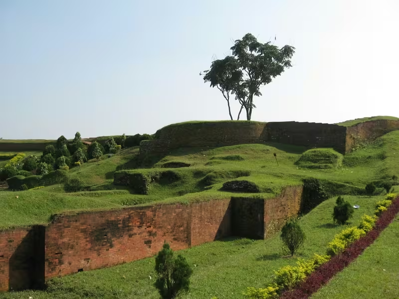
The ancient settlement was known as Pundranagara or Paundravardhanapura and stood within the historical territory of Pundravardhana. Its fortified centre, now called the citadel, is rectangular and covers approximately 185 hectares. High ramparts enclose a landscape of mounds, structural remains, gateways, wells, shrines and later religious buildings. Beyond the walls, archaeological sites extend across a broad suburban zone. Together, the citadel and its surrounding mounds reveal an urban settlement much larger than the surviving central fortification.
Mahasthangarh matters because it connects several layers of Bengal’s past in one landscape. The earliest firmly dated evidence belongs to the Mauryan age, but excavations have exposed occupation layers ranging from the 5th century BCE to the 12th century CE. Coins, ceramics, terracotta plaques, temples, monasteries, Buddhist sculptures, Hindu images, Islamic inscriptions and later traditions all contribute to the site’s history. Yet much remains unknown: the complete plan of Pundranagara and a continuous political history have not been recovered.
Etymology and Names
The modern name combines two words. Mahasthan means a place of excellent sanctity, while garh means a fort. The name therefore describes the location as both sacred and fortified. It is not, however, the earliest name associated with the city.
Mahasthan first appears in a 13th-century Sanskrit text called the Vallalcharita. The anonymous Karatoya mahatmya, conventionally placed in the 12th or 13th century, also mentions the place. That text uses Pundrakshetra, meaning the land of the Pundras, and Pundranagara, the city of the Pundras. These names agree with the identification of the archaeological site as the ancient urban centre of Pundravardhana.
An administrative decree of 1685 calls the place Mastangarh. The term combines Sanskrit and Persian elements and can be understood as a fortified place connected with an auspicious or eminent personage. Later discoveries, especially the early inscription and archaeological evidence, confirmed that Pundranagara or Paundravardhanapura was the older name. Mahasthangarh is consequently a later designation for a much earlier city.
Several names used for individual mounds and buildings preserve local memory rather than securely documented ancient names. Gokul Medh, for example, is also called Behular Basar Ghar or Lakshmindarer Medh and is associated in local tradition with Lakshmindara and Behula. Khulnar Dhap is connected by local naming tradition with Khullana, the wife of Chand Sadagar. Such names are important parts of the living cultural landscape, but they should not automatically be treated as proof of the original purpose of a structure.
Geography and Location
Mahasthangarh lies about 11 kilometres north of Bogra on the Bogra–Rangpur highway. A feeder road runs for approximately 1.5 kilometres along the eastern side of the citadel ramparts, reaching Jahajghata and the site museum. The Karatoya, now a small stream, flows along the eastern side of the citadel. Its earlier size was much greater: as recently as the 13th century, it is described as having been three times wider than the Ganges.
The city stands on the red soil of the Barind Tract, a slightly elevated physiographic unit within a largely alluvial region. The land around the site rises approximately 15 to 25 metres above the surrounding areas, making it comparatively free from flooding. The wider region is described as standing at nearly 36 metres above sea level, while Dhaka is around 6 metres above sea level.
This elevated position probably influenced the choice of the site. A settlement beside a substantial river could benefit from communication and movement, while the higher ground reduced the danger posed by seasonal flooding. The Karatoya’s former size would also have shaped the city’s eastern edge and its relations with the surrounding plain. The river is now much smaller, but its presence remains central to understanding the location of the citadel.
The settlement’s geography extended well beyond the fortified core. Around a hundred mounds are distributed across an area with a radius of roughly 9 kilometres. Excavated and reported sites occur to the north, south, west and southwest, while the Karatoya formed the eastern limit of the main urban area. The evidence suggests a city with a broad suburban zone rather than an isolated fortress.
Ancient History
The earliest firm historical evidence is the Mahasthan Brahmi Inscription. The limestone slab was found in 1931 and is dated to the 3rd century BCE. Its six lines are written in Prakrit using the Brahmi script. Scholars generally understand it as an administrative decree of the Mauryan Empire, recording a land grant. Its importance is twofold: it dates the settlement to at least the Mauryan period, and it shows that the region was integrated into an organised administrative system.
Mahasthangarh is identified as Pundranagara, the capital of Pundravardhana. The city was therefore not simply a rural settlement or a religious site. It was an urban and political centre with a fortified core, an extensive suburb and a long sequence of occupation. The full extent of its Mauryan-period structures has not yet been recovered, but the inscription establishes the city’s importance by the 3rd century BCE.
Excavations have revealed a long archaeological sequence. The Bangla–Franco joint venture exposed 18 archaeological layers, extending from the 5th century BCE to the 12th century CE, down to virgin soil at a depth of approximately 17 metres. This sequence demonstrates repeated construction, rebuilding and occupation. It also warns against viewing the visible mounds as belonging to a single period. Some structures were rebuilt over earlier remains, while later monuments used or transformed older parts of the urban landscape.
The fortified area remained in use until approximately the 8th century CE. Outside it, religious and residential activity continued into later centuries. Stone architectural fragments are dated from the 5th to the 12th century, bronze Buddha sculptures from the 10th and 11th centuries, and Islamic inscriptions from the 14th and 18th centuries. The archaeological record therefore represents continuity and change rather than a single moment of rise and decline.
The Citadel and Its Defences
The citadel is the fortified heart of ancient Pundranagara. It is rectangular, measuring approximately 1.523 kilometres from north to south and 1.371 kilometres from east to west. Its total area is about 185 hectares. High and broad ramparts surround the central zone, with the Karatoya running along the eastern side.
Before excavations began in the 1920s, the interior of the citadel stood more than 4 metres above the surrounding ground. It was covered by scattered elevated mounds and dense vegetation. The rampart itself appeared as a jungle-covered earthen wall, broken by openings at several points. In places it rose 11 to 13 metres above the surrounding land.
A mazhar, or holy tomb, stood at the southeastern corner. A later mosque, built in 1718–19, was also located there. These later structures show that the citadel continued to possess religious significance after the main ancient urban period had passed.
Several named remains survive within the fortifications:
- Jiat Kunda is a well associated with a local belief in life-giving water.
- Mankalir Dhap is linked with the worship of Mankali and has produced terracotta plaques, a bronze Ganesha and a bronze Garuda.
- Parasuramer Basgriha, also called Parasuramer Prasad, is traditionally described as the palace of a king named Parasuram.
- Bairagir Bhita preserves the remains of a structure built or rebuilt through several periods.
- Khodar Pathar Bhita produced fragments of stone carved with a transcendent Buddha and devotees kneeling with folded hands.
- Munir Ghon is identified as a bastion.
- Jahajghata is a flight of steps at the northeastern corner, probably a later addition.
The citadel also has named gateways. Kata Duar lies to the north, Dorab Shah Toran to the east, Burir Fatak to the south and Tamra Dawaza to the west. These names belong to the later historical and local landscape, but the gateways indicate the importance of controlled movement through the fortifications.
Opposite the site museum, just beyond Jahajghata, stands Govinda Bhita. The remains there are associated with a temple and lie close to the Karatoya. The position of the temple, the river and the museum makes this one of the most visible parts of the archaeological complex.
The Suburb of Pundranagara
The ancient city did not end at the citadel walls. Around a hundred mounds are distributed across the wider area, showing that Pundranagara possessed a substantial suburban landscape. Some have been excavated, while many remain unexcavated.
Among the excavated sites are Govinda Bhita, Khulnar Dhap, Mangalkot, Godaibari Dhap, Totaram Panditer Dhap, Narapatir Dhap or Vasu Vihara, Gokul Medh and Skandher Dhap.
Govinda Bhita lies about 185 metres northeast of Jahajghata, opposite the site museum. Remains from the 3rd century BCE to the 15th century CE have been reported, and the base remains of two temples have been exposed.
Khulnar Dhap, situated near the village of Chenghispur, lies about 700 metres west of the citadel’s northwestern corner. Excavation revealed the remains of a temple. Its present name is associated by local tradition with Khullana, the wife of Chand Sadagar.
Mangalkot and Godaibari Dhap are also identified as temple sites. Mangalkot lies about 400 metres south of Khulnar Dhap, while Godaibari Dhap lies about 1 kilometre farther south.
Totaram Panditer Dhap lies in the village of Vihara, approximately 6 kilometres northwest of the citadel. The remains of a damaged monastery have been exposed.
Narapatir Dhap, also called Vasu Vihara, lies in the village of Basu Vihara, about 1.5 kilometres northwest of Totaram Panditer Dhap. Two monasteries and a temple have been identified there. Alexander Cunningham considered it the place visited by the Chinese traveller Xuanzang, or Hiuen Tsang, in the 7th century CE. This identification is an archaeological interpretation rather than a complete description of the site’s history.
Gokul Medh lies about 3 kilometres south of the citadel, near the village of Gokul. Excavations in 1934–36 revealed a terraced podium with 172 rectangular blind cells. The structure is dated to the 6th or 7th century CE. Its local associations with Lakshmindara and Behula have made it one of the best-known monuments in the wider Mahasthangarh landscape.
Skandher Dhap lies in Baghopara, roughly 3.5 kilometres south of the citadel. A sandstone image of Kartika was discovered there, together with the structural remains of a damaged building. The site is considered a possible remnant of Skandha Mandira, a temple mentioned in the Karatoya mahatmya and in Kalhana’s Rajatarangini, written in 1149–50. The same tradition refers to Skandhanagara as a suburb of Pundranagara.
The known extent of the suburbs reaches at least to Baghopara in the southwest, Gokul in the south, Vamanpara in the west and Sekendrabad in the north. The eastern side was shaped by the Karatoya. The full plan of the city, however, remains unknown.
Archaeological Excavations
Systematic excavation began in 1928–29 under the guidance of K. N. Dikshit of the Archaeological Survey of India. The first work focused on Jahajghata, Munir Ghon and Bairagir Bhita. Excavation resumed at Bairagir Bhita and Govinda Bhita in 1934–36.
Further investigations took place in the 1960s around the mazhar, Parasuramer Prasad, Mankalir Dhap, Jiat Kunda and part of the northern rampart. Later work examined sections of the eastern and northern ramparts, although the final report for that phase had not been published in the account of the site.
Between 1992 and 1998, a Bangla–Franco joint venture excavated the area between Bairagir Bhita and a gateway exposed in 1991. A second phase then concentrated on the area around the mazhar on the western side of the citadel. The exposure of 18 archaeological layers, from the 5th century BCE to the 12th century CE, is one of the most important results of this work.
Excavation has also clarified that visible monuments often represent only the latest phase of long-lived locations. At Bairagir Bhita, construction or reconstruction occurred in four periods: the 4th–5th century CE, the 6th–7th century, the 9th–10th century and the 11th century. The surviving base ruins resemble temples, and two sculptured sandstone pillars were recovered.
Parasuramer Prasad also contains evidence from different periods. Finds from the 8th century CE include a stone Vishnupatta of the Pala period. Material from the 15th–16th centuries includes glazed sherds of Muslim origin. Two coins of the British East India Company, issued in 1835 and 1853, represent a much later phase of activity at the location.
At Mankalir Dhap, excavators found terracotta plaques, a bronze Ganesha and a bronze Garuda. The base of a 15-domed mosque, dated to the 15th or 16th century, was also exposed. The mound therefore preserves evidence of more than one religious and architectural phase.
Objects and Inscriptions
The finds from Mahasthangarh represent a wide range of materials.
Inscriptions
The Mahasthan Brahmi Inscription is the most important early object. The small limestone slab contains six lines in Prakrit and Brahmi script and dates to the 3rd century BCE. It records a land grant and is generally interpreted as a Mauryan administrative decree.
An Arabic inscriptional slab dated 1300–1301 records the erection of a tomb in honour of Numar Khan, described as a Meer-e-Bahar, or lieutenant of the naval fleet. A Persian inscription dated 1718–19 records the construction of a mosque during the reign of the Mughal emperor Farrukhsiyar.
Together, these inscriptions span nearly two thousand years of political, religious and administrative history. They also show that the site retained importance after the ancient city’s earliest period.
Coins
Silver punch-marked coins date from the 4th century BCE through the 1st or 2nd century CE. Uninscribed copper cast coins have also been found. Two Gupta-period coins were reported from the nearby village of Vamanpara. Later finds include coins belonging to the sultans of the 14th and 15th centuries and coins of the British East India Company.
The coins do not by themselves provide a complete economic history, but their range supports the picture of a settlement connected to changing political authorities over a long period.
Sculpture and Architecture
The site and its surrounding settlements have produced a 5th-century Buddha in stone from Vasu Vihara, a Lokesvara stone sculpture blending Vishnu and Avalokitesvara, and numerous sandstone door frames, pillars and lintels dated from the 5th to the 12th century. Numerous bronze Buddha sculptures belong to the 10th and 11th centuries.
Other finds include a terracotta Surya from Mankalir Bhita, fragments of stone images and many terracotta plaques. Ceramics are represented mainly by a very large quantity of sherds.
Many representative objects are displayed in the site museum opposite Govinda Bhita. The museum provides a material introduction to the settlement’s long history, from early historic administration to Buddhist, Hindu and Islamic phases.
Religious and Cultural Importance
Mahasthangarh’s religious landscape changed over time. Temples, monasteries, wells, shrines, images and later mosques occupied the citadel and its suburbs. The archaeological remains include Buddhist sculptures, Hindu images and temple foundations, while later inscriptions preserve Islamic monuments and commemorative structures.
Vasu Vihara is especially important for understanding the Buddhist history of the region. It includes the remains of two monasteries and a temple, while a 5th-century stone Buddha was recovered there. The identification of Narapatir Dhap with a place visited by Xuanzang connects the site with the wider history of Buddhist monastic centres in early medieval Bengal, although the identification remains an interpretation based on the available evidence.
The temples of Govinda Bhita, Khulnar Dhap, Mangalkot, Godaibari Dhap and Skandher Dhap show the extent of religious construction around the fortified city. The sandstone Kartika from Skandher Dhap, the bronze Ganesha and Garuda from Mankalir Dhap, and the terracotta Surya demonstrate the range of religious imagery associated with the settlement.
Later sacred associations are equally visible. The mazhar at the southeastern corner of the citadel and the mosque recorded by the 1718–19 inscription belong to later phases of the site. The name Mahasthan itself emphasises sanctity, while local stories continue to associate the mounds with kings, saints and legendary figures.
Legends and Local Memory
A well-known local legend concerns Shah Sultan Balkhi Mahisawar, a mystic said to have arrived from Balkh in Afghanistan riding a fish. Mahisawar is explained as a Persian expression meaning a person who rides a fish. The date of his arrival varies in different tellings: it is placed in the 5th, 11th or 17th century CE.
The story says that a king named Parasuram ruled from Mahasthangarh. Mahisawar asked for only enough land on which to spread his prayer mat. Once placed on the ground, the mat began to expand toward the palace. Parasuram declared war, and at first his forces appeared to have the advantage because the waters of Jiat Kunda were believed to restore dead soldiers to life.
According to the legend, a scavenger named Harapala told Mahisawar about the well’s power. Mahisawar then had a kite drop a piece of beef into Jiat Kunda, after which the water lost its life-giving force. The royal army began to fail, and its commander Chilhan defected to Mahisawar with many followers. Parasuram and members of the royal family then committed suicide.
There are many variations of this story, some circulated in Bengali booklets sold around Mahasthangarh and Pundravardhana. The tale should be read as local cultural memory rather than as a securely dated account of the city’s political history. Its importance lies in the way it gives narrative meaning to the citadel, Jiat Kunda, Parasuramer Prasad and the later sacred landscape.
Beyond the Citadel: Embankments and Nearby Sites
The wider region contains other landscape features and settlements connected with the historical interpretation of Mahasthangarh. Bhimer Jangal is a long embankment beginning near the northeastern side of Bogra town and continuing northward for about 30 miles toward a marshy area called Damukdaher Bit. It is made from the red earth of the locality and still reaches a height of about 20 feet above the surrounding country in places.
The embankment is considered to have had a military purpose, possibly protecting the eastern side of the country. A break near Mahasthangarh may represent erosion or a section where natural protection made construction unnecessary. The Subil stream has sometimes been interpreted as a moat created from earth dug for the embankment, although another interpretation identifies it as the western branch of the Karatoya.
The name Bhimer Jangal has been linked by some interpretations with Bhima, the Kaivarta chief of the 11th century. According to the Ramcharitam, Bhima ruled Varendra after his father Rudraka and uncle Divyoka had displaced the Pala king Mahipala II. Bhima was later defeated and killed by Ramapala, Mahipala’s son. This connection remains an interpretation of the embankment’s name and history.
Other nearby places preserve later religious traditions. Yogir Bhavan is a settlement of the Natha sect of Shaiva ascetics. Its shrines and temples include those dedicated to Kalabhairava, Sarvamangala, Durga and Gorakshanatha. Brick inscriptions at the site record dates corresponding to 1681, 1741 and 1766 CE. The location demonstrates that the wider landscape continued to support active religious communities long after the ancient city’s principal period.
Decline, Survival and Threats
The history of Mahasthangarh is not a simple story of sudden abandonment. The citadel remained in use until approximately the 8th century CE, while the archaeological layers and later inscriptions show continued activity in the wider area. Temples and monasteries were built, rebuilt or replaced, and later Islamic structures occupied parts of the old urban landscape.
The main challenge is that the city’s complete history has not yet been recovered. Many mounds remain unexcavated, and the final report for some rampart excavations was still unavailable in the account of the site. As a result, the relationship between individual buildings, neighbourhoods and historical periods cannot always be established.
Modern threats have also affected the remains. A 2004 report described local looting of bricks and valuables and the construction of residences within the protected area in violation of government regulations. In 2010, the Global Heritage Fund listed Mahasthangarh among 12 sites worldwide considered to be “On the Verge” of irreparable loss and damage. Poor water drainage and looting were identified as major causes of concern.
Preservation therefore requires more than protecting the visible ramparts. The mounds outside the citadel form part of the ancient city and must be understood as elements of a wider archaeological landscape. Drainage, control of construction, protection from looting and continued archaeological documentation are all necessary to preserve what remains.
Modern Visit and Site Museum
Mahasthangarh is accessible from Bogra, which lies about 11 kilometres to the south. Buses from Dhaka reach Bogra in approximately four and a half hours via the Bangabandhu Jamuna Bridge across the Jamuna River. Accommodation is available in Bogra.
The feeder road beside the eastern ramparts leads to Jahajghata and the site museum. The museum stands opposite Govinda Bhita and displays representative discoveries from the excavations. Books on Mahasthangarh and other archaeological sites in Bangladesh, in Bengali and English, are available at the ticket counter.
The listed museum schedule is seasonal. From 1 April to 30 September, it opens from 10:00 am to 6:00 pm, with a recess from 1:00 to 2:00 pm. From 1 October to 30 March, it opens from 9:00 am to 5:00 pm, with the same recess. On Fridays, the recess is from 12:30 to 2:30 pm; the remaining timings follow the stated seasonal schedule.
Visitors encounter a layered site rather than a single monument. The ramparts establish the scale of the ancient fortified city, while the mounds preserve traces of temples, monasteries, wells, gateways and later structures. The museum’s objects—inscriptions, coins, sculptures, plaques and ceramics—make it possible to connect the landscape to particular historical periods.
Timeline
Early archaeological layers
The Bangla–Franco excavations identified occupation layers beginning in the 5th century BCE.
Mahasthan Brahmi Inscription
A limestone slab bearing a Prakrit land-grant record in Brahmi script was produced during the 3rd century BCE.
Early historic urban centre
Pundranagara functioned as the capital of Pundravardhana and remained connected with wider political and economic systems.
Temple and architectural development
Bairagir Bhita and other locations contain remains associated with the 4th and 5th centuries CE.
Monasteries and suburban growth
Gokul Medh is dated to the 6th–7th century, while monasteries and temples developed across the wider settlement.
Xuanzang-associated site
Alexander Cunningham identified Narapatir Dhap or Vasu Vihara as the place visited by Xuanzang in the 7th century CE.
End of the main fortified phase
The fortified area is understood to have remained in use until approximately the 8th century CE.
Arabic inscription
An inscription dated 1300–1301 recorded the erection of a tomb in honour of Numar Khan.
Name Mastangarh
An administrative decree used the later name Mastangarh for the fortified site.
Mosque inscription
A Persian inscription dated 1718–1719 recorded the construction of a mosque during Farrukhsiyar’s reign.
Systematic excavation begins
Archaeological excavation began in 1928–29 under K. N. Dikshit of the Archaeological Survey of India.
Inscription discovered
The Mahasthan Brahmi Inscription was discovered and provided the earliest firm date for the city.
Bangla–Franco excavations
A joint excavation investigated the area between Bairagir Bhita and a gateway exposed in 1991.